Bassett Hall Archaeological Report, Block I Building 22Originally entitled: "Bassett Hall Archaeology Briefing"
Colonial Williamsburg Foundation Library Research Report Series - 1008
Colonial Williamsburg Foundation Library
Williamsburg, Virginia
1990
SUMMARY OF ARCHAEOLOGY AT BASSETT HALL
On December 12, 1930, Perry, Shaw and Hepburn sent a work order to excavate Bassett Hall to the company of Todd and Brown. Four hundred dollars was allocated and they specified that no screening was to be done. We have no positive clues about what was excavated that winter but it was most probably just within and/or around the main house and may have been more the dismantling of the structure than archaeology as it is thought of today. Follow-up correspondence supports this assumption. A February 31, 1931 letter mentions the "archaeological evidence discovered upon razing the modern chimney," and the following May, the Williamsburg Holding Company, for the first time, expresses an interest in conventional archaeology; they propose excavating in the rear yard to find the outbuildings shown on the Frenchman's Map.
This search for the outbuildings had not begun even as late as Oct. 31 of 1931 but was well underway by Jan. 11 of 1932. They were possibly finished by the end of February and definitely by April 2, 1932 when a two page report was sent to H.R. Shurtleff, the director of Research and Record. H.S. Ragland was in charge of the excavations and J.M. Knight drafted the archaeological maps but apparently was not present during the excavations.
The amount of ground surface at Bassett Hall disturbed by this early archaeology is unknown. Excavation areas outlined on the Archaeology and Research Key Map of Restoration Area, Williamsburg, Va. 1932 (Rev. 1933) show five distinct areas of excavation, implying that the large percentage of the Bassett Hall property outside these areas was undisturbed. The strategy for selecting these test areas was described by Ragland:
"careful excavations were made at all sites of buildings indicated on the Frenchman's Map …"
Certainly this strategy would have disturbed the most archaeologically sensitive area in the yard. However after reviewing this archaeological map, the Frenchman's Map and the correspondence relating to this property, I feel that the boundaries of these selected areas were conceivably also influenced by negotiations with the resident Misses Edith Smith and her use of the yard.
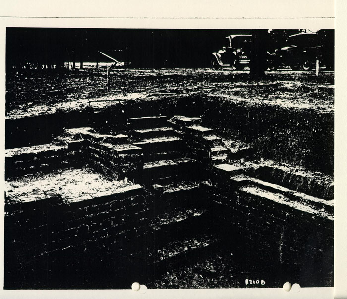
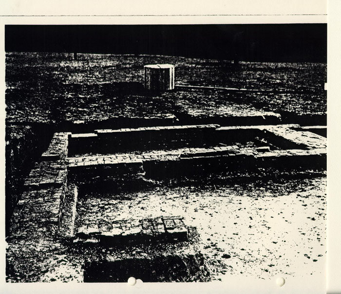
Furthermore, the intensity of excavation within each of these areas is generally unknown. Photographs of the building foundation (section A-1) and the ice house (section A-5) show that the interiors of these features were completely excavated. The photographs are unclear about excavation along exterior walls. Correspondence indicates that the well was dug out also. No record exists for other areas and no trenches are visible in the background of these photographs.
Other than the recording of a few features observed during the monitoring of utility lines in the early 1970's, there was no concern for archaeology at the Bassett Hall until President Humelsine made a statement to the Virginia Gazette on the occasion of the gift of this property to the Foundation on April 18, 1979:
"Humelsine said he didn't think there was any significant 18th century development of the Bassett Hall property other than the plantation house itself, and he doubted that any archaeological work deep in the rolling wooded tract would be undertaken. But he did not rule it out either. 'We're reviewing our whole situation to try to lay out plans for the future. It will be more than a year or more before that plan goes to the board.'"
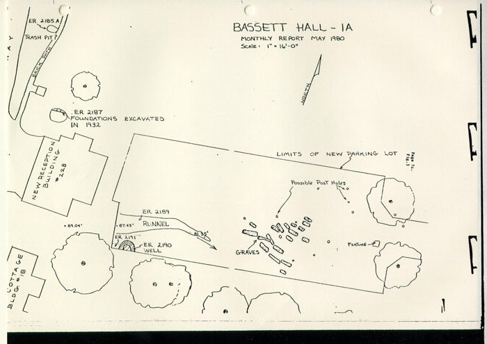
A year later, May of 1980, development on the property (including parking lot construction) revealed several Archaeological features and prompted further archaeological excavation and/or recording of the exposed features. The positions of 18 graves were recorded, several layers of a well were excavated, and tests of a silt-filled gulley were made.
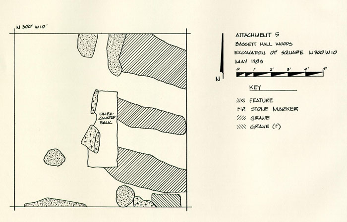
In April of 1983, a ten foot unit was excavated in Bassett Hall woods to determine if a stone marker found by Colonial Williamsburg housewright, Roy Underhill, was a gravestone. The outlines of three, possibly 4 graves were exposed immediately after the upper strata was removed. The graves, markers and accompanying features were photographed and carefully plotted. A report was written by staff archaeologist Bill Myzk and is on file at the OEC office. These findings coupled with those of 1980 suggest that Mr. Humelsine's original assessment was incorrect and that an intensive survey of the woods should be scheduled for 1984/85.
SUMMARY OF FEATURES RECORDED AT BASSETT HALL
In the last 54 years, archaeology has recorded 19 nonextant features at Bassett Hall, including four foundations, two wells, an ice house, three linear features such as paths or walks, three trash pits, a filled-in gulley, two graveyards, an old dam and a couple of artifact concentrations. Many of these recorded features are located just east of the Bassett Hall House: a brick foundation, two wells, a trash pit, the silt-filled gulley and a graveyard. Approximately 400 feet southeast of the Bassett Hall house another group of features were recorded: a chimney foundation, a square pit and two linear brick concentrations thought to be paths. The rest are isolated finds spread across the back yard, along the new entry road to Bassett Hall or in the Woods. A detailed summary of these features accompanies this report. It should be emphasized that these most certainly do not represent an adequate sample of the archaeological resources that may be present in the Bassett Hall property, because past research has suffered greatly from observational biases. Early records reflect a bias toward structural remains, and throughout all 54 years, the selection of excavation areas was dictated either by an architect's interpretation of the Frenchman's Map or the fact that modern development plans unearthed archaeological features. Large areas of the yard have been ignored and the whole of Bassett Hall Woods written off. Accidental discoveries have proven past criteria to be very limiting. A more representative sample of the property needs to be surveyed or tested to characterize the archaeological potential of the lots and the relationships between known features.
Furthermore, even for those features recorded, the records are not of uniform quality and completeness. In the early years, most artifacts were provenienced to a general area rather than linked to a specific feature. Data collected in this fashion cannot be used to answer current research questions. Of the 19 features reported, only 4* have specific proveniences, and after reviewing the records from the early work, I think 2** more may have enough integrity to be useful to future research. The following chart shows the current status of the features recorded at Bassett Hall and identifies these 6 useful proveniences.
| FEATURE — PROVENIENCE | NOT EXCAVATED | PARTIALLY EXCAV. | MOSTLY EXCAV. | UNKNOWN |
|---|---|---|---|---|
| Foundation (kitchen, colonial) - 1-A-1, 2187 | X | |||
| Foundation (colonial) ------ | X | |||
| *Foundation (19th C.)-1A-5-s | X | |||
| Chimney base- 1-A-4 | X | |||
| **Well (18th C)- 1-A-2 | X | |||
| *Well (18th C)- 2190 A, B, C, D | X | |||
| **Ice house - 1-A-5 | X | |||
| Linear feature (paving) - 1-A-4 | X | |||
| Linear feature (paving) - 1-A-4 | X | |||
| Brick sidewalk ------- | X | |||
| *Silt filled gulley - 2189 A, B, C sample | X | |||
| *Trash pit 2185 A sample | X | |||
| Square pit - 1-A-4 | X | |||
| Squarish feature | X | |||
| Small concentration of brick & mortar - 1-A-3 | X | |||
| 18th C. layer - ? | X | |||
| Graveyard - ? | X | |||
| Graveyard -------- | X | |||
| Dam, pond & assoc. road ______ | X |
BIBLIOGRAPHY
Audiovisual
Photograph inventory for Blocks 1 + 40
BASSETT HALL
YORK STREET PROPERTIES
| 50 W 908 | Foundations |
| Swem 44 | Benjamin Waller, Morecock house 1920-21 |
| H194 | " " house Pre-Restoration |
| H193 | backyard |
| Be14 | graveyard |
| Na1748 | Benjamin Waller House Pre-Restoration |
| 64-4339 | " " " entrance to Bassett Hall |
| 65-D-1596 | " from Dementi negative — early 1930s |
| 50-W-398 | Waller house — South Garden Pre-Restoration |
| 51T-2143 | Antique Foundations Benjamin Waller Smokehouse |
| 50-W-861 | Waller, Benjamin Archaeology — tunnel West End |
| 50-W-860 | " " — smokehouse |
| 51-W-64 | " house Progress — Foundations |
| 51-W-65 | Foundation |
| 51-W-67 | " |
| 51-W-66 | " |
| 51-W-864 | " |
| 51-T-841 | Foundation |
| 50-W-394 | pre-restoration |
| 48-T-1074 | c. 1911 Benjamin Waller house |
| 51-W-1151 | Benjamin Waller henhouse excavation |
| 50-W-870 | excavation |
| 50-W-862 | well excavation |
| 50-W-868 | kitchen South excavation |
| 50-W-857 | Benjamin Waller outbuilding excavations |
| 50-W-866 | " " tunnel west end excavation |
| 50-W-871 | Dairy excavation |
| 50-W-869 | tunnel east end |
| 50-W-907 | Benjamin Waller foundations |
| 50-W-863 | front entrance foundation |
| 51-P-501 | storehouse excavation |
| 51-W-63 | house progress foundation |
| 51-T-1782 | well- progress |
| 50-W-865 | Waller, Benjamin office NW elevation |
Audiovisual
Photograph inventory for Blocks 1 + 40
BLDGS. 4-14
| TB113 | Armistead |
| TB114 | Armistead |
| TB116 | Savage House moved from Block 8 (14A) |
| TB115 | Floyd Powell House 154 York Rd. (5) |
| N6299 | Floyd Powell Outbuildings (4) |
| TB403 | draining of Waltz Farm Property |
| N6315 | Powell lot excavation (5) |
| N6314 | excavation Powell lot |
| N4576 | Floyd Powell House (wrecked) (5) |
| H183 | Floyd Powell |
| N6300 | " " destroyed |
| N6301 | Floyd Powell " |
| N4577 | Floyd Powell wrecked |
| N882 | Armistead bungalow before restoration (12) |
| N881 | Armistead bungalow and outbuildings (13 + 13A) |
| N899 | Armistead North elevation (14) |
| N905 | Steel Property Outbuildings now wrecked |
| N4613 | Savage house in new location moved from Bl. 8 |
| N904 | Steel Property outbuildings now wrecked |
| 64-4342 | 1931 Block 1, Francis Street facing east across from Bassett Hall |
Photos Acquired from Audiovisual
| Bassett Hall | pre-restoration and Excavation |
|---|---|
| N5505 | Bassett Hall Well Foundation |
| N3566 | Foundations east of Bassett Hall looking NE at old foundation |
| N2189 | Bassett Hall ice house foundation |
| N2188 | " " " " |
| N2187 | " " " " |
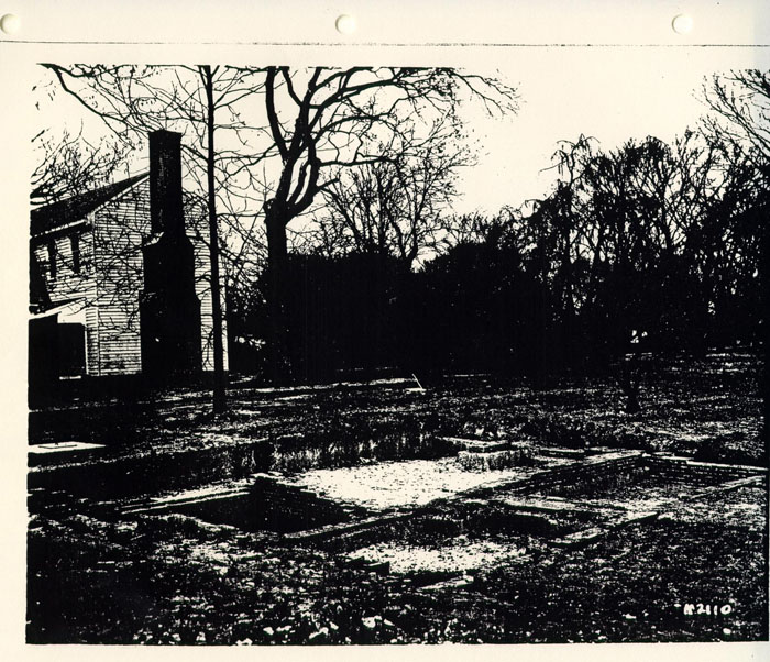
| N2111 | " " outbuildings foundation |
| N2110 | " " " " |
| H195 | Bassett Hall |
| Na1342 | " " outbuildings |
| S41 | Bassett Hall |
| 64-4203 | Bassett Hall Landscaping |
| 49-W-671 | " " Tulip Garden (removed) |
| 64-4351 | " " Landscape |
| TBI21 | Watz farm Property drainage — Bassett Hall Woods |
| N-3639 | Bassett Hall Landscaping move in cedar tree |
| TB-403 | Draining of Watz Farm Property |
| N3569 | Bassett Landscaping Progress Picture |
| N3640 | " Hall Landscaping - placing the cedar tree |
| N3641 | removing the cedar tree |
| 64-4335 | Move. 1936 Entrance to Bassett Hall |
| TB119 | Watz farm property drainage Bassett Hall Woods |
| N1966 | Bassett Hall Grounds |
| N3668 | Bassett Hall |
Map File A in Map Archives, Goodwin Building
Maps useful for the Block by Block Management Plan
BLOCK 1
- Benjamin Waller
File No. 74-11-8-6
Topographic Map of the Waller House
14 April 1950 1/6"=1' - Benjamin Waller House
Layout and Grading Plan L1
1 November 1950 1'=18' - Benjamin Waller House
Location and Plot Plan; Utilities Location
1 November 1950 1"=16' - Planting Plan L2
1 November 1950 1/16"=1' - Bassett Hall Estimate Plan L6
20 November 1931 2-'=1" - Survey of Vicinity of Bassett Hall
20'=1' (outbuildings and contours)
12 November 1938
revised 21 October 1929 - Plan of Preliminary Routing for Southern By Pass
26 March 1969 1"=200' - BLOCK 40
Site Plan for Williamsburg Restoration Nursery L1
20 November 1956 1"=100' - Preliminary Master Site Development
New Construction and Maintenance Facilities
15 September 1976 1"=50' - Brafford Tract Topo Survey Bldg. 60
Proposed Warehouse Relocation
February 1975 1"=40'
available maps
Top ARCH drawer
Goodwin Building
Map and Machine Room
useful for Block by Block Management Plan
| 1B | Archaeology Survey of Foundations - Benjamin Waller Property |
| 18 August 1950 ¼"=1' | |
| 1A | Archaeology Survey of Foundations Bassett Hall property |
| 1 April 1932 ¼"=1' | |
| 1C | Archaeology Survey of Foundations of Powell House |
| Located South Side of York Street | |
| 18 March 1940 ¼"=1' | |
| 1B | Benjamin Waller sheet 2 |
| None |
ARCHAEOLOGY-OEC
PRESENT ACQUISITIONS
BLOCK I MAPS
21 June 1983, Tuesday
Arthur A. Shurtleff
Landscape Architect
ULTIMATE LAYOUT FOR BASSETT HALL
- WILLIAMSBURG RESTORATION INCORPORATED SKETCH FOR PROPOSED PATH AT BASSETT HALL
Shurcliff
40' = 1"
December 23, 1936
Revised to May 6, 1937
Revised to November 15, 1937 - FOREST MAP SHOWING WOODED AREAS AND ADJOINING THE PROPERTIES OF COLONIAL WILLIAMSBURG INCORPORATED WILLIAMSBURG
RESTORATION INCORPORATED
1"=600'
September 12, 1947
updated through January 4, 1962 - 1-B BENJAMIN WALLER HOUSE: LOCATION + PLOT PLAN:
UTILITIES LOCATION
Scale 1"=16'-0"
1 November 1950
D.H.P. - B(ENJAMIN) WALLER (HOUSE) DEMOLITION PLAN
Scale 1/16"=1'-0" - REPAIRS TO GRAVE YARD WALL AT WALLER HOUSE BLOCK 1
Colonial Williamsburg, Incorporated
Architecture Department
31 July 1941
Scale - As Noted - BASSETT HALL 8" FIRE LINE + FIRE HYDRANT INSTALLATION
30 June 1980
Scale - As Noted
R.F.C.
Bldg. 22 No. P-2 - 1-B ARCHAEOLOGICAL SURVEY OF FOUNDATIONS ON BENJAMIN WALLER PROPERTY
18 August 1950 Scale ¼"=1'-0"
J.M.K. - BASSETT HALL - REVISIONS TO PLANTING AT ENTRANCE GATES;
LOCATION FOR NEW LIGHTS ALONG DRIVE L 15
28 September 1965
1'=20'
| Bassett Hall | (Building 22) | AMR VOLUME 1 |
| April 22-June, 1982 | ||
| Artifact Context | ||
| 1A-5-1 | ||
| 1A-5-2 | ||
| Bassett Hall | (Building 22) | AMR VOLUME 1 |
| May 13, 1983 | ||
| Artifact Context | ||
| no finds | ||
| Bassett Hall | (Building 22) | AMR VOLUME 1 |
| April 27, 1983 | ||
| Artifact Context |
FEATURE SHEETS
SUMMARY SHEET — KNOWN ARCHAEOLOGICAL FEATURES
BLOCK 1
Bassett Hall
FEATURE: Chimney base, colonial
CATALOGUE #: within 1-A-4
DESCRIPTION:
remains of a double chimney base (brick) 10'2"x8'5".
brick are 9"x4 ½"x 2 ½" English bond, shell mortar.
LOCATION:
329.13' south, 190' east of NE corner of Bassett Hall House
ASSOC. ARTIFACTS REPORTED:
REPORTED DEPOSITION OF ARTIFACTS:
CURRENT COLLECTION STATUS:
INVESTIGATOR(S):
1932: H.S. Ragland, in charge of Arch. Excavations
CONDITION:
unknown, was at least excavated down to top of bricks
PAST INTERPRETATION & SIGNIFICANCE:
EXCAVATION TECHNIQUE:
unknown
SUMMARY SHEET — KNOWN ARCHAEOLOGICAL FEATURES
BLOCK 1
Bassett Hall
FEATURE: brick foundation, colonial (possibly kitchen)
CATALOGUE #:Within 1-A-1
ER 2187
DESCRIPTION:
This foundation has two periods of construction, a large chimney, cellar and large bricks (9"x4½"x2½") laid in English bond with oyster shell mortar
LOCATION:
60 feet due east of Bassett Hall House, 12 feet north of new Bassett Hall reception building (bldg. 22B)
ASSOC. ARTIFACTS REPORTED:
fragments of a casement window (brittle lead and diamond shaped glass)
REPORTED DEPOSITION OF ARTIFACTS:
sent to Rutherfoord Goodwin at the old high school (1932)
CURRENT COLLECTION STATUS:
INVESTIGATOR(S):
first quarter, 1932; H.S. Ragland, in charge of archaeological excavation
May, 1980: Dept. of Archaeology, CWF (J. Hammond?) recorded, photographed and backfilled portion of this foundation when it was rediscovered upon the removal of an oil tank.
CONDITION:
Based on 1980 evidence, brick foundation still extant but 1932 photo suggests the interior has been entirely excavated.
PAST INTERPRETATION & SIGNIFICANCE:
1980-Dept. of Archaeology, CWF: "18th century foundation"
1932-Shurtleff, Director of Research & Record, CWF: "…might reasonably push the date of this foundation back to 1700 or even before … we are dealing with a very old site—I should think the oldest that we have come across in Williamsburg …."
1932-Ragland, in charge of Archaeological Excavations: "Its (chimney's) immense size suggests that the building may have been a kitchen"
EXCAVATION TECHNIQUE:
unknown
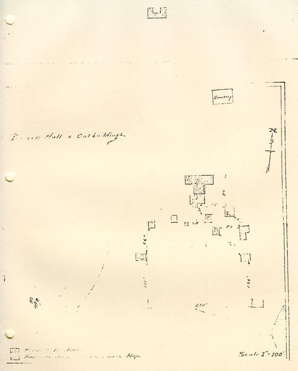
 PLOT PLAN — OLD FOUNDATIONS & PRES. BLD'GS.
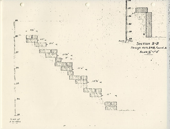 SECTION B-B

SUMMARY SHEET — KNOWN ARCHAEOLOGICAL FEATURES
BLOCK 1
Bassett Hall
FEATURE: Well, Colonial
CATALOGUE #: within 1-A-2
DESCRIPTION:
This well is adjacent to "kitchen" foundations (1-A-1). In 1932, it was described as a good sealed colonial context so we can hope that this provenience has some integrity. The diameter is 3' 5 ¼". Photo shows evidence of square foundation around well.
LOCATION:
125" east and 35'8" south of the NE corner of Bassett Hall House, 29'11" east of 1-A-1 foundations.
ASSOC. ARTIFACTS REPORTED:
unshattered bottle with contents intact in 1932
REPORTED DEPOSITION OF ARTIFACTS:
sent to Mr. Rutherfoord Goodwin at the old high school
CURRENT COLLECTION STATUS:
INVESTIGATOR(S):
1932: H.S. Ragland, in charge of archaeological excavations
CONDITION:
excavated fill, brickwork may still be intact
PAST INTERPRETATION & SIGNIFICANCE:
1932, H.R. Shurtleff: "only well in town which has yielded practically nothing but what is colonial in period… we are dealing with a very old site-I should think the oldest we have come across in Williamsburg."
EXCAVATION TECHNIQUE:
unknown

 PHOTOGRAPH — Excavation (N5505)
SUMMARY SHEET — KNOWN ARCHAEOLOGICAL FEATURES
BLOCK 1
Bassett Hall
FEATURE: brick sidewalk
CATALOGUE #: NONE
DESCRIPTION:
small section (3'4" N-S x 3'9" E-W) of N-S running brick walkway. Bricks were not joined with mortar but some were heavily coated with shell mortar indicating prior usage. Walk seated on a thin layer of cinders above sterile subsoil.
LOCATION:
near telephone vault on York St., just inside fence and 50-60 ft eat of entrance road to new reception building parking lot at Bassett Hall.
ASSOC. ARTIFACTS REPORTED: no artifacts associated with walk
REPORTED DEPOSITION OF ARTIFACTS:
CURRENT COLLECTION STATUS:
INVESTIGATOR(S):
1983 — OEC, P. Samford monitored C&P cable installation
CONDITION:
Only a portion of this walkway was destroyed by the installation of the telephone cable. Northern portion had been destroyed earlier by the installation of a telephone vault.
PAST INTERPRETATION & SIGNIFICANCE:
EXCAVATION TECHNIQUE: manually excavated by C&P workers
SUMMARY SHEET — KNOWN ARCHAEOLOGICAL FEATURES
BLOCK 1
Bassett Hall
FEATURE: Old dam, pond, & assoc. road
CATALOGUE #: None
DESCRIPTION: old broken earth dam on ravine with a level bottom (probably formed by sediment when ravine was pond). The ravine extends NW toward the east end of Ireland St. Traces of an old road are evident on the NE side of the pond site leading to the dam.
LOCATION: The dam is about 1000 ft SW of Bassett Hall House across a ravine.
(see additional comments)
ASSOC. ARTIFACTS REPORTED: NONE
REPORTED DEPOSITION OF ARTIFACTS:
CURRENT COLLECTION STATUS:
INVESTIGATOR(S):
1932: H.S. Ragland, in charge of archaeological excavations
CONDITION: intact? never excavated
PAST INTERPRETATION & SIGNIFICANCE:
1932 - H.S. Ragland: "must have been built in the colonial period
EXCAVATION TECHNIQUE: no excavation done
SUMMARY SHEET — KNOWN ARCHAEOLOGICAL FEATURES
BLOCK 1
Bassett Hall
FEATURE: Structure foundation & fill
CATALOGUE #: 1A-5-2
DESCRIPTION:
brick & concrete foundation wall. Interior fill consists of brick and mortar rubble with timbers and concrete slabs.
LOCATION:
50-68 ft south of fence that surrounds field (on York St.) and approx 125 ft east of older main driveway into Bassett Hall.
ASSOC. ARTIFACTS REPORTED:
late 19th and 20th century artifacts and some 18th century pottery sherds.
REPORTED DEPOSITION OF ARTIFACTS: OEC
CURRENT COLLECTION STATUS: OEC
INVESTIGATOR(S):
April, 1980: P.M. Samford & D. Nolin, monitoring utility trench placement
CONDITION: largely intact
PAST INTERPRETATION & SIGNIFICANCE:
1980- OEC: "appears to be on of the houses torn down at restoration"
EXCAVATION TECHNIQUE:
mechanically dug by backhoe during water line placement, recorded by OEC
SUMMARY SHEET — KNOWN ARCHAEOLOGICAL FEATURES
BLOCK 1
Bassett Hall
FEATURE: Late 18th century Strata
CATALOGUE #: ?
DESCRIPTION:
"undisturbed" strat reportedly containing a quantity of bottle and carboy fragments
LOCATION:
just off the southwest corner of smokehouse
ASSOC. ARTIFACTS REPORTED:
bottle and carboy fragments
REPORTED DEPOSITION OF ARTIFACTS:
not described in report
CURRENT COLLECTION STATUS:
INVESTIGATOR(S):
Landscape department discovered layer during the removal of a large boxwood. The hole was backfilled before the Archaeology Department learned of the discovery.
CONDITION:
probably largely intact around boxwood hole
PAST INTERPRETATION & SIGNIFICANCE:
glass thought to be of American manufacture dating from the 18th century
EXCAVATION TECHNIQUE:
discovered and dug and backfilled by landscape department while removing a boxwood
SUMMARY SHEET — KNOWN ARCHAEOLOGICAL FEATURES
BLOCK 1
Bassett Hall
FEATURE: small concentration of brick & mortar
CATALOGUE #: within 1-A-3
DESCRIPTION:
J.M.K. map shows area to be only approx. 3 ft. in diameter. Feature described once as consisting of fragments of brick and mortar and once as brick debris.
LOCATION:
approx 270 feet south and 264 feet west of the NE corner of Bassett Hall House
ASSOC. ARTIFACTS REPORTED:
REPORTED DEPOSITION OF ARTIFACTS:
CURRENT COLLECTION STATUS:
INVESTIGATOR(S):
1932: H.S. Ragland, in charge of archaeological excavations
CONDITION: unknown
PAST INTERPRETATION & SIGNIFICANCE:
1932—H.S. Ragland, in charge of arch. excavations: "…may perhaps indicate the site of…an outbuilding shown on the Frenchman's map.
EXCAVATION TECHNIQUE:
"Careful excavations were made at all sites of buildings, indicated on the Frenchman's map."(Ragland 1932)
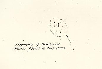 Fragments of Brick and Mortar found in this area.
SUMMARY SHEET — KNOWN ARCHAEOLOGICAL FEATURES
BLOCK 1
Bassett Hall
FEATURE: Ice house
CATALOGUE #: 1-A-5
DESCRIPTION:
Ice house has a diameter of 16'9" and 9" walls. The brick foundations have light red bricks with shell mortar(bricks are 9 ½ x 4 ½ x 2 ⅓ and 8 ½ x 4 x 2 ¼ inches)
LOCATION:
687 feet south and 272 feet east of NE corner of Bassett Hall House. Located south and west of ravines.
ASSOC. ARTIFACTS REPORTED:
no information given
REPORTED DEPOSITION OF ARTIFACTS:
CURRENT COLLECTION STATUS:
INVESTIGATOR(S):
1932: H.S. Ragland, in charge of Arch. excavations
CONDITION:
may be some lower fill intact.
Photos of what appears to be the bottom of section shown on the JMK map, show only small square test holes down into what appears to be fill.
PAST INTERPRETATION & SIGNIFICANCE:
1932 — J.M. Knight (map) "colonial brickwork"
1932 — Ragland, "Miss Edith Smith told me that there had been an ice house at that location"
EXCAVATION TECHNIQUE:
unknown
 Foundation — Ice House
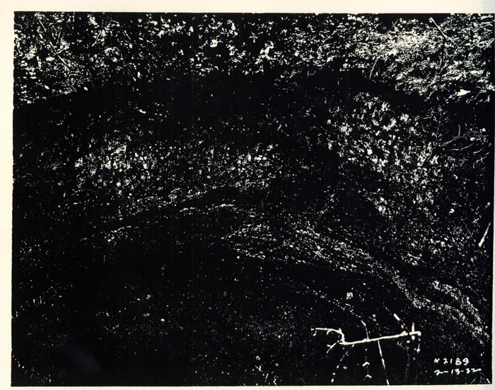 Photograph (N2189)
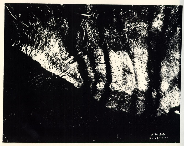 Photograph (N2188)
 Photograph (N2187)
 Photograph of Excavation (N2178) (?)
SUMMARY SHEET — KNOWN ARCHAEOLOGICAL FEATURES
BLOCK 1
Bassett Hall
FEATURE: Small square pit
CATALOGUE #: within 1-A-4
DESCRIPTION:
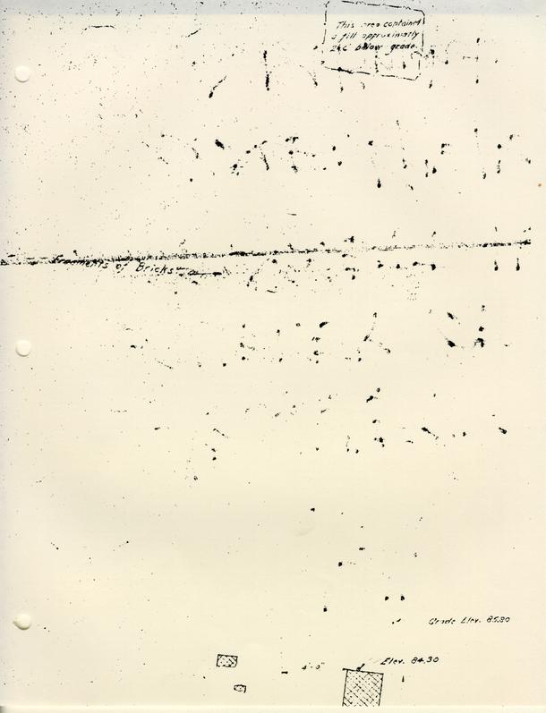
approx 6' E-W by 4' N-S (orientation of long axis slightly NW- SE, same as nearby chimney foundation and possible paving) "contained a fill 2'6" below grade"
LOCATION:
approx. 380' south and 185' east of NE corner of Bassett Hall House. approx 35-40' south of double chimney base and approx 12' from possible paving.
ASSOC. ARTIFACTS REPORTED:
no information given
REPORTED DEPOSITION OF ARTIFACTS:
CURRENT COLLECTION STATUS:
INVESTIGATOR(S):
1932: H.S. Ragland, in charge of arch excavations
CONDITION:
unknown, but probably excavated since depth of fill recorded
PAST INTERPRETATION & SIGNIFICANCE:
no written report, only description On J.M.K. 1932 map
no statement made
EXCAVATION TECHNIQUE:
unknown
SUMMARY SHEET — KNOWN ARCHAEOLOGICAL FEATURES
BLOCK 1
Bassett Hall
FEATURE: Linear feature, possible path paving
CATALOGUE #: within 1-A-4
DESCRIPTION:
Concentration of brick fragments, that are 34' long and run east to west (slightly SE to NW) which is the same orientation as the double chimney base(also within 1-A-4)
LOCATION:
approx 370' south, 200' east of NE corner of Bassett Hall House.
also approx 25' south of double chimney base.
ASSOC. ARTIFACTS REPORTED:
REPORTED DEPOSITION OF ARTIFACTS:
CURRENT COLLECTION STATUS:
INVESTIGATOR(S):
1932: H.S. Ragland, in charge of arch. excavations
CONDITION:
unknown
PAST INTERPRETATION & SIGNIFICANCE:
no written report on this feature, the only description is on JMK map and a rough sketch by Ragland, 2/32.
1932—Ragland: "brick remains possibly paving in old path"
EXCAVATION TECHNIQUE:
unknown
SUMMARY SHEET — KNOWN ARCHAEOLOGICAL FEATURES
BLOCK 1
Bassett Hall
FEATURE: Linear feature, unknown function
CATALOGUE #: within 1-A
DESCRIPTION:
long narrow concentration of brick and mortar fragments
LOCATION:
approx 400 ft south and 200 ft east of NE corner of Bassett Hall House
ASSOC. ARTIFACTS REPORTED:
no information given
REPORTED DEPOSITION OF ARTIFACTS:
CURRENT COLLECTION STATUS:
INVESTIGATOR(S):
1932: H.S. Ragland, in charge of arch. excavations
CONDITION:
unknown
PAST INTERPRETATION & SIGNIFICANCE:
no written report, only description given on JMK 1932 map.
No Statement made
EXCAVATION TECHNIQUE:
unknown
SUMMARY SHEET — KNOWN ARCHAEOLOGICAL FEATURES
BLOCK 1
Bassett Hall
FEATURE: Well
CATALOGUE #: 2190A B,C,D
DESCRIPTION:
greatly eroded sides
9 ft E-W by 8 ft N-S
see back for description of top five layers:
LOCATION:
southwest corner of parking lot, some 35 ft east of the new reception building (bldg. 22B)
ASSOC. ARTIFACTS REPORTED:
medal commemorating the victory at Porto Bello (2190B)
REPORTED DEPOSITION OF ARTIFACTS: Dept. of Arch.
CURRENT COLLECTION STATUS: OEC
INVESTIGATOR(S):
1980 - Dept. of Arch, CWF
CONDITION:
Four fill layers and a silt layer excavated (approx. top 7 ½ ft). Fill beneath the silt probed another 3 ft. (at least) and was backfilled and preserved for future excavation.
PAST INTERPRETATION & SIGNIFICANCE:
1980—Dept.of Arch.: "deposit seems to date ca. 1745-50"
"The presence of chimney bricks and burned plaster tends to indicate that layers 2190B,C,D, —1A were made up of material generated from the dismantling of a previously burned structure.
EXCAVATION TECHNIQUE:
not described
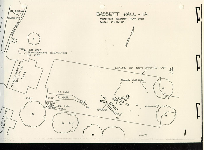
 BASSETT HALL — 1A
SUMMARY SHEET — KNOWN ARCHAEOLOGICAL FEATURES
BLOCK 1
Bassett Hall
FEATURE: Trash pit
CATALOGUE #: 2185A
DESCRIPTION:
contained many 18th century wine bottle fragments and other domestic trash.
size unknown
LOCATION: 35 feet east of main house
ASSOC. ARTIFACTS REPORTED: 18th century wine bottles, other domestic trash.
variegated green marble doorknob with cameo inset (1810-1830) found in vicinity of pit.
REPORTED DEPOSITION OF ARTIFACTS: Department of Archaeology
CURRENT COLLECTION STATUS: O.E.C.
INVESTIGATOR(S): Department of Archaeology
CONDITION: After recording, the trench was backfilled to preserve the pit for future excavation
PAST INTERPRETATION & SIGNIFICANCE:
1980—Dept. of Arch., CWF: "dating from the late 17th century to the early 18th century" (April)
"dating to the late 18th century" (May)
EXCAVATION TECHNIQUE: unearthed during utility line placement
 BASSETT HALL — 1A
SUMMARY SHEET - KNOWN ARCHAEOLOGICAL FEATURES
BLOCK 1
Bassett Hall
FEATURE: Graveyard
CATALOGUE #: ?
DESCRIPTION: 18 graves possibly enclosed within post and rail fences.
LOCATION: under the parking lot near the new reception building
ASSOC. ARTIFACTS REPORTED: none
REPORTED DEPOSITION OF ARTIFACTS:
CURRENT COLLECTION STATUS:
INVESTIGATOR(S):
1980 — Dept. of Arch., uncovered by grading for parking lot
CONDITION: graves undisturbed and parking lot completed over them
PAST INTERPRETATION & SIGNIFICANCE:
1980… Dept. of Arch., CWF: "probably date to a period before 1860-65." "The evidently Christian burial ground … appeared to contain the graves of adults, adolescents, and infants ….
EXCAVATION TECHNIQUE: uncovered by grading for parking lot. Dept. of Arch. just recorded the Positions of the burials
 BASSETT HALL — 1A
SUMMARY SHEET — KNOWN ARCHAEOLOGICAL FEATURES
BLOCK 1
Bassett Hall
FEATURE: Silt-filled gulley
CATALOGUE #: 2189 A,B,C
DESCRIPTION:
erosion channel that is at least 25 ft long with an East-West axis and contains burned artifacts
LOCATION: 6 ft north of well near new reception building
ASSOC. ARTIFACTS REPORTED:
REPORTED DEPOSITION OF ARTIFACTS:
CURRENT COLLECTION STATUS:
INVESTIGATOR(S):
1980: Dept. of Archaeology, CWF
CONDITION:
Test excavations done only, so probably mostly intact
PAST INTERPRETATION & SIGNIFICANCE:
EXCAVATION TECHNIQUE: tested, not fully excavated
 BASSETT HALL — 1A
SUMMARY SHEET— KNOWN ARCHAEOLOGICAL FEATURES
BLOCK 1
Bassett Hall
FEATURE: Structure foundation
CATALOGUE #: NONE
DESCRIPTION:
1½ brick wide foundation running E-W and a 2 brick wide foundation running N-W
LOCATION:
to the Southeast of the new visitor's entrance gate on York St. at Bassett Hall
ASSOC. ARTIFACTS REPORTED: no artifacts recovered
REPORTED DEPOSITION OF ARTIFACTS:
CURRENT COLLECTION STATUS:
INVESTIGATOR(S):
1981 - Dept. of Arch. arrived after hole backfilled
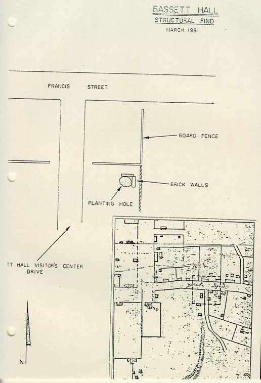
CONDITION: intact other than planting hole intrusion
PAST INTERPRETATION & SIGNIFICANCE:
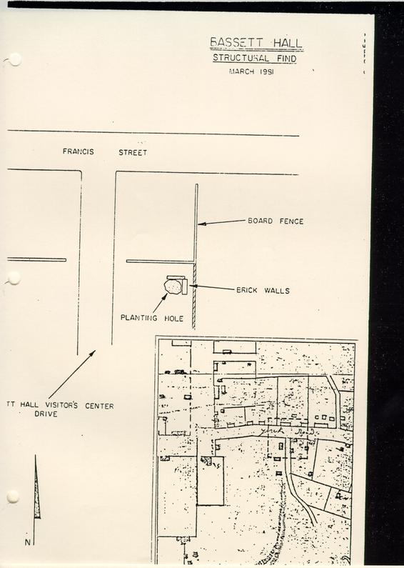
1981- Dept. of Arch: "These foundations are of particular interest in that they lie in an area that is shown on the Frenchman's Map to have had heavy colonial occupation."
EXCAVATION TECHNIQUE:
tree planting crew uncovered and backfilled the hole; archaeologists just made a quick back check.
 BASSETT HALL STRUCTURAL FIND
SUMMARY SHEET — KNOWN ARCHAEOLOGICAL FEATURES
BLOCK 1
Bassett Hall
FEATURE: Graveyard
CATALOGUE #:
DESCRIPTION:
3 possibly 4 graves oriented NW to SE, 2 upright limestone markers (one inscribed PB or FB, 1726/27) and postholes.
LOCATION:
near the east edge of Bassett Hall woods along Quarterpath Rd. (see Myzk's report for exact location)
ASSOC. ARTIFACTS REPORTED:
locally made pipe stem, unidentified iron piece, wine bottle kick
REPORTED DEPOSITION OF ARTIFACTS: OEC
CURRENT COLLECTION STATUS: OEC
INVESTIGATOR(S):
April, 1980 —(marker discovered by CWF housewright Roy Underhill) OEC staff, B. Myzk & R. Hunter
CONDITION: graves undisturbed markers removed to OEC lab
PAST INTERPRETATION & SIGNIFICANCE:
1980—OEC: "the postholes may suggest that the graves were enclosed by a wooden fence." "The grave and artifacts certainly support the fact that an archaeological site exists in the Basset Hall Woods … (and) underscores the need for a comprehensive inventory of cultural resources located within the woods."
EXCAVATION TECHNIQUE: a 10 ft test square was dug down to subsoil
 Attachment 5 — Bassett Hall Woods
SUMMARY SHEET — KNOWN ARCHAEOLOGICAL FEATURES
BLOCK 1
Bassett Hall
FEATURE: "feature"
CATALOGUE #:
DESCRIPTION:
squarish feature shown on May 1980 monthly report map
LOCATION:
located at the point the entry road to Bassett Hall widens into the reception building parking lot, between two trees and east of the 18 graves now under the parking lot.
ASSOC. ARTIFACTS REPORTED: NONE
REPORTED DEPOSITION OF ARTIFACTS:
CURRENT COLLECTION STATUS:
INVESTIGATOR(S):
1980 — Dept. of Archaeology, CWF: uncovered by grading for parking lot
CONDITION:
probably not dug and now sealed by parking lot
PAST INTERPRETATION & SIGNIFICANCE:
no written record, only reference is on May 1980 monthly report map
EXCAVATION TECHNIQUE:
uncovered by grading for parking lot, Dept. of Archaeology just recorded the location.
A number of potential archaeological features have been recorded by Colonial Williamsburg Foundation employees but not investigated by the archaeology staff. These features at Bassett Hall include:
EARTHWORKS:
In Bassett Hall Woods on either side of Quarterpath road, "may be seen long, low ridges-remnants of entrenchment for Confederate riflemen." (memo—D. Parker 10/10/80)
OLD FENCE LINES AND CROP FURROWS:
"Vestiges of old fence lines and crop furrows can still be discerned" in the predominately pine forest of Bassett Hall Woods (Bassett Hall Woods Pamphlet, CWF). "the area south of the great oak is high and relatively flat for about ¼ mile on either side of the vista. At one time prior to the Civil War, the area was comprised of cleared fields for cultivation (memo—D. Parker 10/10/80)
.
QUARTERPATH ROAD:
This road "is of 18th century origin. Tradition records that its name derived form the popular sport of racing quarterhorses—along the road." (memo—D. Parker 10/10/80)
.
INTERVIEWS
Block 1 #22 Bassett Hall 1932-33-34-35
- January 12, 1932
more excavations needed near outbuildings, - Research report January 26, 1932
Bassett Hall Historical Data
by Department of Research and Record - February 13, 1932
further appropriations for excavations approved. - January 4, 1933
relocation of smokehouse - January 4, 1933
relocation of kitchen - January 4, 1933
relocation of dairy - April 4, 1933
completion of smokehouse - April 4, 1933
completion of dairy - April 4, 1933
completion of kitchen - April 4, 1933
completion of Excavations
Researched 6/9/1983
Block 1 #22 Bassett Hall 1927-28-29-30-31
- December 8, 1930
excavating at Bassett Hall property (no screening) work order.
Researched 6/8/1983
14 June 1983
Jimmy Knight
Bassett Hall
digging 1932 had been dug before he arrived
Was in progress when he arrived
house earlier than Bassett Hall
well
bottle — story hooked up to it.
theory — before Williamsburg
along horse path — Middle Plantations
Wednesday — 22 June 2:00-2:30
interview with JAMES M. KNIGHT by Andrea K. Foster
22 June 1983
Bassett Hall and Benjamin Waller
Blocks 1 + 40
BLOCK 1
recalls Waller house and bungalows to the east.
Benjamin Waller excavated house and outbuildings.
chicken house in backyard.
left graveyard alone.
Bassett Hall ice house down in ravine in pretty good shape.
dome — part — barrel shape brick dome.
dirt over top. someone had broken through.
once cleaned found old entrance
front entrance grown up in the 1930s.
photos for sites excavated in Audiovisual.
BLOCK 40
cottage — colonial house torn down near east drive
hardest oyster shell mortar he'd seen.
Mr. Knight arrived after Bassett Hall was excavated.
he drew it up. excavations — 1930-1931.
PERRY, SHAW AND HEPBURN
ARCHITECTS
141 MILK STREET, BOSTON, MASS.
AND
WILLIAMSBURG, VIRGINIA
WILLIAMSBURG, VIRGINIA
DATE: December 18th, 1980
Block No. 1 Building No.Name of
To MESSRS TODD & BROWN Williamsburg, Virginia
In accordance with Authorization No 98-C (Green Work Order: Date: December 8th, 1930) you are authorized to proceed with the [two lines of text over-stricken]
excavating (no screening) at Bassett Hall property in Block 1.
Amount of Authorized Estimate: $400.00
Copy to:
T. & B., N Y.
W. H. C., (Wmsburg. and N. Y.
H. R. S., Wmsburg.
P. S. & H., Boston
PERRY, SHAW and HEPBURN
by JOSEPH W. GEDDES
PERRY, SHAW AND HEPBURN
ARCHITECTS
141 MILK STREET, BOSTON, MASS.
AND
WILLIAMSBURG, VIRGINIA
FEB 4 1931
THOMAS MOTT SHAW
ANDREW H. HEPBURN
-------
WALTER M. MACOMBER
February 3, 1931
WILLIAMSBURG CONCERNING—Bassett Hall —
Block 1, Building #22
Williamsburg Holding Corp.,
Williamsburg, Va.
Dear Sirs:
We are submitting herewith Change Order No. 1 on Bassett Hall, in the amount of $600.00.
You will-note that this is the estimated cost of altering the rear chimney in accordance with our drawing No. 101, revised January 23, 1931. The revision shows an enlargement of the chimney to agree with archaeological evidence discovered upon razing the modern chimney, which work is, of course, necessary for an authentic restoration.
We recommend the acceptance of Todd & Brown's estimate for this change.
If this work has your approval, please return to us seven signed copies of the Change Order, for distribution.
Yours very truly,
Perry, Shaw and Hepburn
By
Joseph W. Geddes
EGP
Encl.
Copy to:
P. S. & H., Boston
May 19, 1931
Miss Edith Smith
Bassett Hall
Williamsburg, Virginia
Dear Miss Edith,
In re: Block 1, No. 22 — Bassett Hall
We are very anxious to do some additional excavating at the rear of your home to determine definitely the location of the outbuildings as shown on the Frenchman's Map.
Before doing this, we want to be sure that it will it not inconvenience you, and we will appreciate it very much if you will advise us whether it will be satisfactory to you for us to do this excavating immediately.
If you wish any more definite information, I shall be very glad to have Mr. Ragland call on you in person and explain what he wants to do.
Trusting you will advise us, we are
Yours very truly,
WILLIAMSBURG HOLDING CORPORATION
By
V. M. Geddy
NOV 2 1931
PERRY, SHAW AND HEPBURNWILLIAMSBURG, VIRGINIA
October 31, 1931
Bassett HallPerry, Shaw and Hepburn
141 Milk Street
Boston, Massachusetts
Gentlemen:
Attention: Mr. Shaw
In reply to your letter of October 26, we are advised by Mr. Chorley that he has not yet made such negotiations with the Misses Smith that the research excavation work in the vicinity of the outbuilding location shown on the Frenchman's Map can proceed.
Very truly yours,
Perry, Shaw and Hepburn
By: JOSEPH W. GEDDES
JWG.OLD
Copy:
WHC., Wmsburg
CORRESPONDENCE
JAN 12 1932
PERRY, SHAW AND HEPBURN
ARCHITECTS
141 MILK STREET, BOSTON, MASS.
AND
WILLIAMSBURG, VIRGINIA
WILLIAM G. PERRY
THOMAS MOTT SHAW
ANDREW H. HEPBURN
--------
HAROLD R. SHURTLEFF
WALTER M. MACOMBER
JOSEPH W. GEDDES
WILLIAMSBURG
January 11, 1932
CONCERNING
Block 1 — Bassett Hall-
Outbuildings — Excavations
Williamsburg Holding Corporation
Williamsburg
Virginia
Gentlemen:
We enclose, herewith, Change Order No. 1, covering further excavations in the vicinity of Bassett Hall Outbuildings. This increase is made necessary on account of the finding of foundations of a large building with a basement and further excavations are necessary to complete the location of the outbuildings.
If approved, will you kindly sign the enclosed forms and return to us for distribution.
Very truly yours,
PERRY, SHAW AND HEPBURN
BY Joseph W. Geddes
MO
Enc.
Copy to P. S. & H., Boston
January 12, 1932
Perry, Shaw and Hepburn
Williamsburg
Virginia
Dear Sirs,
In re: Block 1, No. 22 — Bassett Hall
We are herewith returning to you, duly signed, nine copies of Change Order No. 1, in the sum of [scratched out] for excavation work in the vicinity of the Bassett Hall Outbuildings.
Very truly yours,
WILLIAMSBURG HOLDING CORPORATION
By
Kathryn T. Bowen
Enc.
Copy to:
PS&H — Boston
PERRY, SHAW AND HEPBURN
ARCHITECTS
ADDRESS ALL COMMUNICATIONS TO:
HAROLD R. SHURTLEFF, DIRECTOR
RESEARCH AND RECORD DEPARTMENT
P. O. BOX F
WILLIAMSBURG, VIRGINIA
January 28, 1932
NOTES CONCERNING OLD DAM AND POND:
Across a ravine, about 1000 feet, southwest of Bassett Hall House, there is an old broken earth dam — clear evidence that there was, years ago, a large pond in the ravine, which extends northwestwardly toward the eastern end of Ireland Street. Other unnatural topographical features in the ravine also indicate the former existence of a pond of considerable size. A fairly level bottom extending for several hundred feet northwestwardly from the dam is a good indication of a fill in the ravine made by sediment, and therefore that water covered the area for a long time. As the dam evidently has been broken for many years, and the pond existed for a long time, it must have been built in the colonial period.
No evidence of a mill has been found, but there are traces of an old road on the northeast side of the pond site, leading to the dam. The dam is on the property owned by Mrs. Haughwout, adjacent to the Bassett Hall property.
Herbert S. Ragland
HSR: mm
Harley -
Report on an early excavation at Bassett Hall, in case you don't have it. [illegible]
Perry, Shaw and Hepburn
141 Milk Street
Boston, Massachusetts
Dear Sirs,
It begins to appear as if the old foundations almost due east of Bassett Hall, which have been uncovered recently, and of which you probably know as much or more than I do, are in all probability very old and very confusing. The bricks are almost identical with the early Palace bricks, and to my mind look very much like the Green Spring bricks if my memory serves me right.
The fact that this house was not shown on the Frenchman's Map makes it reasonable to suppose that it had already been torn down by the time the map was made, which might reasonably push the date of this foundation back to 1700 or even before.
In addition to that, fragments of leaded glass casement window have been found, which Mr. Rutherfoord Goodwin now has over at the old high school. The lead is very brittle (and lead less than any other metal goes to pieces when buried in the ground - the Palace lead for instance which has been buried is still pliable and in very good shape,) and the fragments of glass retained in the diamond shaped leaded fragment is old as the oldest piece of discolored glass in the old high school. In addition to that Mr. Dimmick was taken to see this leaded glass window fragment by Mr. Goodwin, and told the latter that it was almost exactly the same as the pieces of leaded glass that he found at Greenspring Manor, except that the lead was a little heavier.
On top of this, the adjacent well proved to be about the only well in town which has yielded practically nothing but what is colonial period. So it looks as if we were dealing with a very old site - I should think the oldest that we have come across in Williamsburg.
Does not all of this, particularly in view of Fiske Kimball's feeling and Dr. Goodwin's feeling that if there were any legitimate reason for putting up a 17th century house in Williamsburg it should be done, mean that we should consider this aspect of the case very seriously?
 Mr. Shurcliff
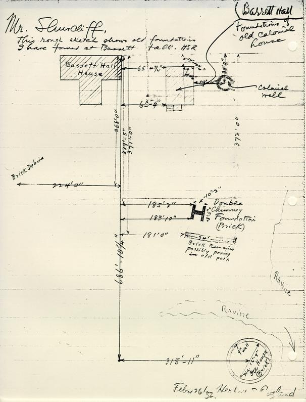
This rough sketch shows old foundations I have found at Bassett Hall. HSR

"Archaeological Survey of foundations — Bassett Hall" scale ¼"=1'0"
1 April 1932 To: H. R. Shurtleff, Director of Research & Record
From: H. S. Ragland
Subject:Archaeological Report on Old Foundations found on Bassett Hall Property, Williamsburg, Virginia.
Date: April 2, 1932.
Submitted herewith is an archaeological drawing showing old foundations recently found by excavation on the Bassett Hall property.
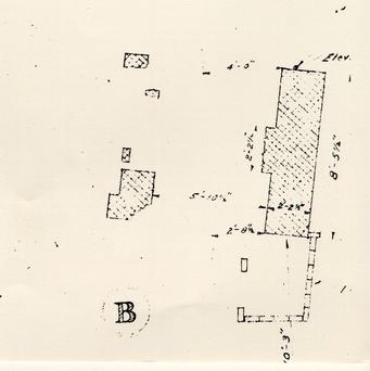
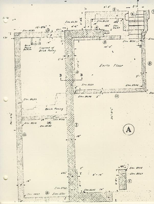
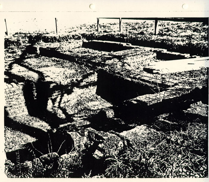
Foundation "A", found about 80 feet east of Bassett Hall house, appears to be a very old foundation. The bricks are Palace size, (9"x4½"x2½" or 2 5/8"); the bond, English; the mortar, oyster shell. Two periods of construction were found. The original walls are Nos. 1, 2, 3, 4, and 5. In the North East corner, a very large chimney, formed by walls 1, 2 and a part of 3, was found. Its immense size (8'-10" wide x 4' 8½" deep), suggests that the building may have been a kitchen. At the south end of the building at No. 5, another chimney foundation was found. The cellar, enclosed by walls Nos. 8, 9, 10 and 11, was evidently dug out after building was completed, for the footings of the original walls are three feet above the floor. Original walls 3 and 4 were partially undercut and underpinned by walls 9 and 10. The original eastwest wall was not found but apparently wall No. 7 indicates its location, and that it was slightly underpinned by wall No. 8. Cellar steps were found at No. 6. A glance at the
Page 2
plan is sufficient to show that they were built after the chimney.
Walls Nos. 12, 13, 14 and 15 are not bonded to original wall No. 3, and are evidently the foundations of an addition.
Many objects and articles of the colonial period were found in excavating the old well and foundation "A". They were turned over to Mr. Goodwin.
At "B" remains of a double colonial chimney foundation were found, and about 250 yards South east of Bassett Hall house the foundation of an ice house was uncovered. Miss Edith Smith told me that there had been an ice house at that location.
Careful excavations were made at all sites of buildings, indicated on the Frenchman's Map, but no other foundations were found. However, about 250 feet South west of Bassett Hall house, approximately at the location of an outbuilding shown on the Frenchman's Map, fragments of brick and mortar were found, which may perhaps indicate the site of that building.
Herbert S. Ragland
In chg. of Arch. Excavations
HSR/vbl
From: H. S. Ragland
Subject: Archaeological Report on Old Foundations found on Bassett Hall Property, Williamsburg, Virginia.
Date: April 2, 1932.
Submitted herewith is an archaeological drawing showing old foundations recently found by excavation on the Bassett Hall property.
Foundation "A", found about 80 feet east of Bassett Hall house, appears to be a very old foundation. The bricks are Palace size, (9"x4½x2½" or 2 5/8") the bond, English; the mortar, oyster shell. Two periods of construction were found. The original walls are Nos. 1, 2, 3, 4, and 5. In the North East corner, a very large chimney, formed by walls 1, 2 and a part of 3, was found. Its immense size (8'-10" wide x 4' 8½" deep), suggests that the building may have been a kitchen. At the south end of the building at No. 5. another chimney foundation was found. The cellar, enclosed by walls Nos. 8, 9, 10 and 11, was evidently dug out after building was completed, for the footings of the original walls are three feet above the floor. Original walls 3 and 4 were partially undercut and underpinned by walls 9 and 10. The original eastwest wall was not found but apparently wall No. 7 indicates its location, and that it was slightly underpinned by wall No. 8. Cellar steps were found at No. 6. A glance at
Page 2
the plan is sufficient to show that they were built after the chimney.
Walls Nos. 12, 13, 14 and 15 are not bonded to original wall No. 3, and are evidently the foundations of an addition.
Many objects and articles of the colonial period were found in excavating the old well and foundation "A". They were turned over to Mr. Goodwin.
At "B" remains of double colonial chimney foundation were found, and about 250 yards South east of Bassett Hall house the foundation of an ice house was uncovered. Miss Edith Smith told me that there had been an ice house at that location.
Careful excavations were made at all sites of buildings, indicated on the Frenchman's Map, but no other foundations were found. However, about 250 feet South west of Bassett Hall house, approximately at the location of an outbuilding shown on the Frenchman's Map, fragments of brick and mortar were found, which may perhaps indicate the site of that building.
Herbert S. Ragland
In chg. of Arch. Excavations
HSR/vbl
 BASSETT HALL AND OUTBUILDINGS
 BASSETT HALL AND OUTBUILDINGS
FINDS LIST
 Blocks 1 & 7
[HANDWRITTEN NOTE]
April 22, 1982
Bassett Hall utility Trench
50 ft South of Fence that Surrounds Field Foundation wall — brick & concrete
18 ft Further S — fill between brick & mortar rubble mixed with timbers & concrete slabs late 19th & 20th C [artifact] & some 18th C pottery sherd
"appears to be one of the [illegible] mapped & photographs OEC 82 0014-23-32
Artifact #
1A-5-1
1A-5-2
7B-1
FINDS LIST
Artifact # 1A-5-2
Bassett Hall
Utility Trench, 50' into field 4/29/82
- Chinese porcelain, overglazed red & gold, underglazed blue
- Opaque white "porcelain" whiteware
- Whiteware saucer & plate frags.
- Pearlware (platter?) base frags.
- Shell mortar or plaster
- Mortar, modern with grout
- Whiteware, T.P. pale blue
- Porcelaneous plate frag, blue transfer printed
- Chinese porcelain, blue underglazed
- Creamware, annular
- Creamware, plain
- 18 C. wine bottle glass
- Glass, modern green
- Yorktown, buff coarseware
- Glass, clear, drinking vessel?
- White Salt Glazed Stoneware, dipped
- Glass, window, modern
- Nails, iron
- Brown Stoneware
- White Kaolin pipe stem
- Bone
- Plaster, lath marked
- Unglazed red coarseware flower pot stand
- Brick, bat, burned
- Wooden window muntin frag.
- Iron wire
- Cast iron pipe frag.
- Brass misc.
- Brass, spoon?, handle frag.
Artifact #7B-1
Bassett Hall
Utility Trench 4/29/82
- Iron Coffee Mill handle
- Iron bolt discarded 8/11/83 BP
- Iron horseshoe frag. discarded 8/11/83 BP
- Iron carriage? fitting
- Iron round head bolt discarded 8/11/83 BP
- Stone, natural discarded 8/11/83 BP
- Pearlware, H.P. blue
- Porcelaneous, molded, gilded saucer frags
- White Salt Glazed rolled rim chamber pot frags
- Chinese Porcelain, blue underglazed lid & cup frags, Canton
- Whiteware
- 18 C. (late) wine bottle
- Redware Doorknob
Artifact # 7B-1
Bassett Hall
Utility Trench 4/30/82
- Glass, clear, modern, molded wine bottle, 1 pint capacity marked, "MONARCH WINES"
- Bone discarded 8/11/83 BP
- Glass, pale aqua, bottle , molded (2 necks, 1 base frag)
- Glass, brown, modern beer bottle?) iron - discarded 8/11/83 BP
- Nails, iron - discarded 8/11/83 BP
- Glass, 18 C. wine bottle base frags discarded 8/11/83 BP
- Glass, clear, modern, preserve jar lid
- Glass, clear, modern, molded bottle base or possible decanter?
- American stoneware, blue and grey pitcher frags, incised capacity mark: 1½
- Porcelaneous, white
- Pearlware, T.P. blue plate frag.
- Whiteware, molded, plain
- Glass, clear, modern discarded 8/11/83 BP
- Glass, window pane, modern? discarded 8/11/83 BP
- Brass spoon bowl
Artifact # 1A-5-1
Bassett Hall
Spoil 6/9/82
- American stoneware, blue and grey
- Glass, 18 c. wine bottle frags discarded 8/11/83 BP
- Salt Glazed Stoneware, scratch blue, debased
- Chinese porcelain
- Glass, modern, cobalt blue discarded 8/11/83 BP
- Whiteware, plate or saucer base frag. green T.P. mark on bottom,
...P. CO
..._V
...ING, O.
Artifact # 1A-5-2
Bassett Hall
Utility Trench, 1st field area from road to 30' south
- Whiteware
- Porcelaneous door knob? frag.
- Pearlware, green shell edge plate
- Flint, knapped edge
- delftware, blue on white bowl frag
- Glass, 18 c. wine bottle frags
- Whiteware, blue T.P. plate or soup plate
1A-5-1
Bassett Hall
Utility Trench
- Glass, pale green
- Whiteware, annular, banded, polychrome
- Whiteware, plain, plate rim
- Whiteware, polychrome, cup frags?
1A-5-1
Bassett Hall
Utility Trench 6/16/82
- Glass, 18 c. late or 19 c. early molded kick bottle
- Glass, clear, molded jar frag. screw top discarded 8/12/83 BP
- Brown stoneware, bottle? frag.
- German, blue and grey stoneware frag
1A-5-1
Bassett Hall
Utility Trench 6/15/82
- American stoneware, Albany slip-type interior glaze
- Creamware, plain
- Glass, 18 c. bottle
- White Salt Glazed Stoneware frag
1A-5-1
Bassett Hall
Utility Trench 5/12/82
- Creamware, plain cup frag
- Pearlware, blue shell edge plate frag
- Porcelaneous, whiteware cup (London shape)
1A-5-1
Bassett Hall
Utility Trench 6/18/82
- Glass, 19 c. green bottle
- delftware, glaze sherd, plain white
- Chinese porcelain, overglazed gold, underglazed blue
- Nail, iron discarded 8/12/83 BP
- Pearlware, T.P. blue plate frag
- Pearlware, blue shell edge plate rim frag
- Creamware/whiteware
- North Devon, gravel tempered, coarseware
- Redware, clear lead glazed
- Glass, window
- White Salt Glazed Stoneware
1A-5-1
Bassett Hall
Utility Trench 6/23/82
- Glass, pale aqua, bottle, molded with letter "D"
- Glass, window, pale green discarded 8/12/83 BP
- Glass, 18 c. wine bottle
1A-5-2
Bassett Hall
Utility Trench, 50' into field
- delftware, blue on white, drug pot, and plain white bowl rim frag
- Door knobs, iron
- Brass misc.
- Iron misc.
- Side cutters? iron, possible electrician's pliers
BLOCK 1 Building 22
Telephone Cable Installation
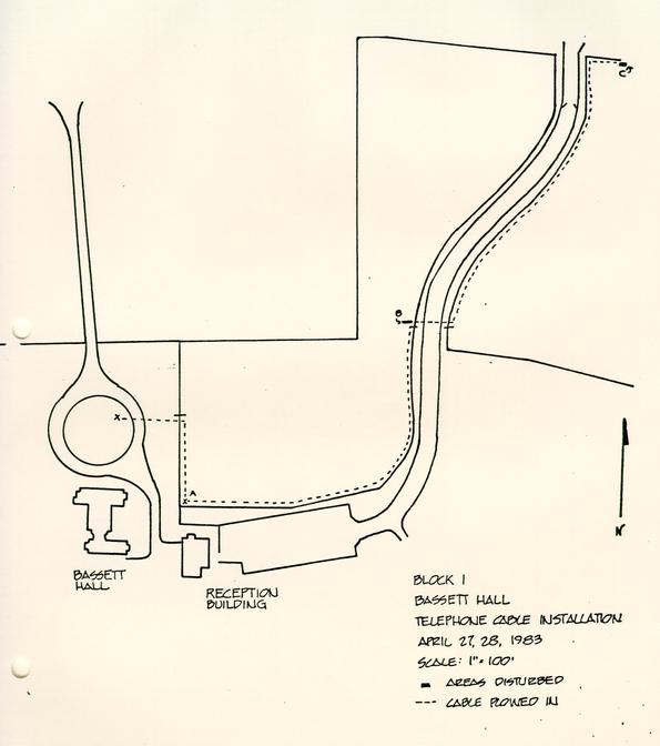
On May 13, 1983, private contractors working for Chesapeake and Potomac Telephone Company buried a telephone cable for a press platform to be located in front of Bassett Hall. The cable was extended northward from a previously installed "pop-up pedestal" located inside the field to the immediate east of Bassett Hall (see accompanying map). The cable was plowed into the ground at a depth of six to ten inches. Although archaeological excavations in the early 1930's (see report on file at Architectural Research) located an eighteenth century structure and well in the field where the cable was buried, this work did not disturb anything of archaeological significance. This is explained by the shallow depth at which the cable was buried and that the foundations were located farther to the east than the line of the cable. Approximately one hundred and twenty-three feet from the "pop-up pedestal" the cable made a ninety degree turn and ran parallel with the front of Bassett Hall. The cable terminated in another "pop-up pedestal" located inside the circle in front of Bassett Hall. No artifacts were recovered from the trenching.
monitored by Patricia Samford
May 13, 1983
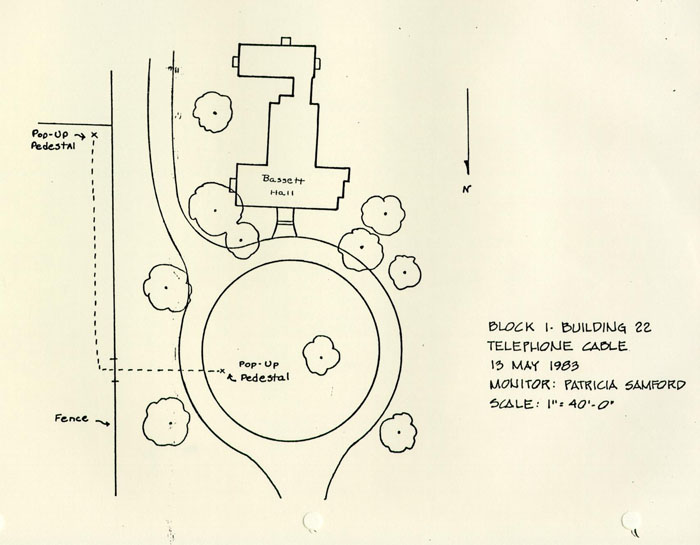 BLOCK 1 — BUILDING 22
TELEPHONE CABLE
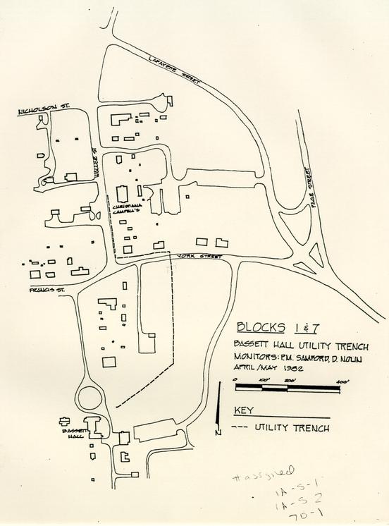
BLOCK I Bassett Hall
Telephone Cable Installation
On April 27 and 28, 1983, private contractors working for Chesapeake and Potomac Telephone Company buried a summit-related telephone cable at Bassett Hall. Beginning in the field immediately north of the reception building (Building 22B), workers installed a "pop-up pedestal" (see accompanying map). This pedestal was located in the extreme southwest corner of the field. The trench for the pedestal (Area A) was mechanically excavated and measured 1'6" NS by 3'8" EW by 2'0" deep below ground level. one foot of grey loam topsoil covered yellow clay subsoil.
Eastward from Area A, a cable was buried by plow. This technique causes very little surface disturbance, so nothing of archaeological significance was noted. The cable followed the line of the fence defining the limits of the field and was buried three feet inside the fence at a depth of two feet. The cable continued northward towards York Street.
Along the north-south running service road, the cable turned ninety degrees and crossed under the road. This enabled the cable hook-up to a vault located on York Street. A trench on the west side of the field was mechanically excavated in order to push the cable under the road. Area B measured 17'0" EW by 9" NS by 2'4" deep below ground level. The stratigraphy in this hole was composed of 1'7" of grey loam topsoil overlying yellow clay subsoil.
After being buried under the road, the cable was plowed northward toward the vault on York Street. Buried at a depth of two feet, the cable was located three feet to the east of the fence line.
Area C represents a manually excavated trench for connecting the cable to the telephone vault. The area disturbed measured 5'1" EW by 1'9" NS by 1'1" deep. The excavation of this trench cut a brick sidewalk running in a north-south direction. The sidewalk was located eight inches below ground and was covered with three inches of dark grey loam topsoil and five inches of light grey sandy loam. The bricks measured 4" x 3" x 8" and were purplish and red/orange in color. The bricks were not mortared together, but some of the brick showed evidence of heavily shelled mortar. This indicated the reuse of these brick. The remains of the sidewalk to the north had been destroyed by the prior installation of a telephone vault. The remaining sidewalk measured 3'9" EW by 3'4" NS, which was determined by probing in the area not disturbed. The sidewalk rested on an inch thick bed of cinder overlying yellow clay subsoil. There were no artifacts from the disturbed area to aid in dating the sidewalk.
Bassett Hall Artifact List
- 2 whole brick
- 2 partial brick
 BLOCK 1 BASSETT HALL
TELEPHONE CABLE INSTALLATION
MONTHLY REPORTS
MONTHLY REPORT ON ARCHAEOLOGICAL ACTIVITIES
April 1973
The following work was undertaken or completed during the month of April, 1973:
EXCAVATIONS
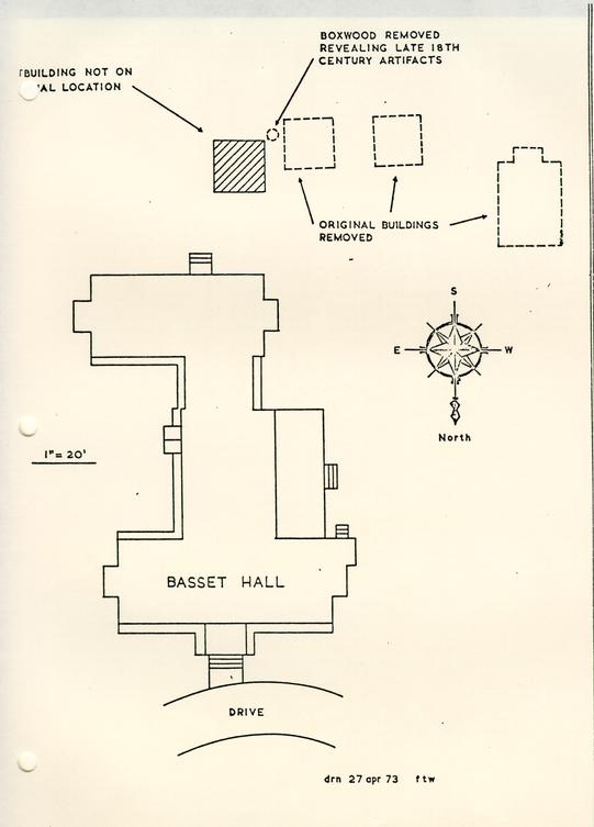
Bassett Hall Property : The removal of a large boxwood from this site by the Landscape Department on April 16, produced a quantity of bottle and carboy fragments. Some are thought to be of American manufacture dating from the fourth quarter of the eighteenth century. The hole was located off the southwest corner of the smokehouse (see attached plan), and the artifacts were reportedly found in undisturbed stratigraphy there. The work had been completed and the hole backfilled before this department learned of the discoveries.
Public Hospital Site : This season's activity began on April 11, in the area of the hospital's southerly porch. The initial work was confined to removing various layers of straw, leaves, and plastic put there last winter to protect the strata and foundations from the elements. Two new areas located east of the porch were topsoil and the modern intrusions removed, so by the first part of May, work will begin on the dismantling of the many paving layers in this area.
WORK ON THE COLLECTIONS
Final storage of the artifacts from the Public Hospital excavations of 1972 continues and it is hoped to have the indices ready for typing by the end of May. The finds from the Miller-Peyton Randolph lot have been indexed and stored. Work has been resumed on the final indexing of the James Geddy artifacts, a task which will be worked upon whenever the processing of the finds from the current Public Hospital excavation permits.
Other projects undertaken but not completed during April included some further study of English porcelain, a survey of sites in Williamsburg from which delft tiles were excavated, continuing work on the museum project, and cataloging of the objects illustrated in the gardening booklet.
[Sept. 1975]
[…]area, including a rowlock-laid brick walk dating from the later years of the eighteenth century. The trench also exposed a section of the western wall of the John Lockley House. (Fig. 5) Future construction plans call for this trench to be continued into the area of the backfilled cellar hole, which (on the evidence of photographs of the 1951 excavations) appears not to have been fully explored. Consequently, when construction begins on the test rooms, it will be necessary to keep a close watch on the early phases of the work.
On September 23 an electrical line was dug along Francis Street in the vicinity of Bassett Hall. This trench fortunately followed the course of a previous modern utility line and exposed no archaeological features.
[illegible]The [illegible]ons
The processing of the Anderson artifacts continues, as does the preparation of the indices. It is hoped to begin the cross mending in mid-November.
Other projects undertaken this month have included the provision of items suitable for reproduction by the Merchandising Department, and the selection and cataloging of slides for Mr. Noël Hume's lectures.
[HIS]TORY
| New Work | Started | Completed |
|---|---|---|
| Iron: | ||
| James Anderson (10.A) | 69 | 41 |
| Amelung | 39 | 27 |
| Brass: | ||
| James Anderson (10.A) | 17 | 17 |
| Bone: | ||
| James Anderson (10.A) | 5 | 5 |
| Pewter: | ||
| James Anderson (10.A) | 6 | 6 |
MONTHLY REPORT ON ARCHAEOLOGICAL ACTIVITIES
April 1980
The following work was undertaken and completed during the month of April, 1980.
EXCAVATION
Excavations at the Public Hospital during April have uncovered additional details of the 1844 wing (see Figure 1), a four foot wide robber trench marks the position of the south or back wall of the wing. To date, the trench extends a distance of 75' without any indication of turning. The robber trench apparently was dug not only to salvage bricks from the foundation wall of the wing which was completely robbed, but also from a wall located 09" outside the addition. This secondary wall, portions of which are still intact, may have been an area wall or possibly facilitated drainage around the addition.
The north or front wall of the wing also was robbed, leaving only a trench to show where it had stood. Like the south face of the east wing, a brick foundation was also found just outside the front wall. A portion of vaulted brick drain was found at the northwest corner of the wing. The drain is oval in section, an unusual construction technique. Above the drain, additional brickwork was discovered, perhaps the remains of a manhole allowing access to it.
Much of the wing's semi-basement apparently possessed a brick floor covered with a layer of concrete. However, one ten foot square (ER 2273) revealed a series of slots for seating sleepers. This different floor treatment suggests that the room or rooms over it were employed for a different or special function, as yet unidentified.
Portions of the exercise yard wall which predated the addition have also been uncovered. About two feet outside the south wall of the 1844 wing, 66 feet of the ca. 1800 exercise yard wall has been found. Modern utilities have obliterated the west end of the wall where would have adjoined the main building.
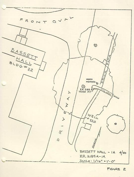
Additionally, the Department of Archaeology has periodically checked on the excavation of numerous utility trenches in the restored area. One such trench at Bassett Hall was found to have cut through a trash pit dating from the late 17th century to the early 18th century, (see Figure 2).
[WO]RK ON THE [CO]LLECTIONS
The processing of the current finds from the Public Hospital site is behind schedule.
 BASSETT HALL — 1A 4/80
FIGURE 2
 BASSETT HALL — 1A 4/80
ER 2185-1A
Monthly Report
May, 1980
NICHOLAS/TYLER
On Monday, May 5th, the Archaeology Department received word that artifacts had been unearthed by a backhoe while digging a water line trench across the Nicholas/Tyler lot (Block 4, Area A). Upon examining the trench, the decision was made that the remainder of the feature within the proposed trench should be excavated archaeologically. Removal of the artifact laden fill (E.R. 2186F,G-4A) revealed a flat bottomed, vertical sided hole cut into the natural clay. The hole, measuring 19' 03" N/S was set on a north/south axis, and appeared to be the trash filled remains of a brick-robbed cellar (see Figure 2). A silted ditch or ravine (E.R. 2186H-4A), set on a northwest/southeast axis was located beneath the floor of the cellar, thus pre-dating it, (see Figure 2). The cellar's primary fill contained large quantities of domestic trash dating to the first quarter of the 18th century, but the silt-filled ditch was free of cultural material.
Late in April, a hole (E.R. 2184-4A) some eight feet east of the trench had been investigated when a boxwood was removed. That hole revealed a trash-filled feature cutting across the west side, one later identified as the east side of the cellar hole. The combination of the evidence from these two investigations provided the location for the south, east and north limits of the cellar. All of the above features were recorded, and then backfilled so that they might be preserved for future excavation.
BASSETT HALL
In May several important archaeological features were discovered during construction and renovation projects at Bassett Hall (Block 1, Area A).
A trash pit (E.R. 2185-lA) dating to the late 18th century had been unearthed while digging a utility trench. This feature, located some 35 feet east of the main house (see Figure 3) contained many 18th century wine bottle fragments and other domestic trash. An unusual surface fine from the vicinity of the pit was a variegated green marble doorknob with a cameo inset, which appears to date around 1810-1830. After recording, the trench was backfilled to preserve the pit for future excavation.
The removal of an oil storage tank on May 14th uncovered the remains of a brick foundation (see Figure 3). Located some 12 feet north of the new Bassett Hall reception building (Building [Pag]e 3 22-B), the foundation was determined to be that of an early 18th-century building that had been excavated by Mr. Herbert Ragland in 1932. As the feature had already been investigated it was recorded, photographed and backfilled.
While investigating the previously mentioned foundation, time was taken to look for features in the area recently cleared for a parking lot (see Figure 3). This investigation brought to light the existence of a cemetery containing, perhaps, eighteen graves (see Figure 3). The evidently Christian burial ground (possibly enclosed within post and rail fences) appeared to contain the graves of adults, adolescents, and infants. That determination was based solely on the size of the graves themselves, for none of the graves were investigated. Consequently no determination could be made as to race or age of the burials, although they probably date to a period before 1860-65 as no documentation mentioning the location of the cemetery exists. After conferring with the Colonial Williamsburg legal offices the decision was made to leave the graves undisturbed After recording the positions of the burials, the area was released to the contractor for completion of the parking area.
In it's southwest corner, some 35 feet east of the Building 22-B, a well was discovered (see Figure 3). The greatly eroded sides of the well shaft measured 9 feet east-west by 8 feet north-south within the cleared area and contained four layers. The capping layer (E.R. 2190A-1A), dating to the second half of the 18th century was composed of dark loam fill used to level out a sink hole. Beneath that layer was found a fill, (E.R. 2190B-1A), made up of brickbats, mortar lumps, oyster shells and domestic trash was cut by E.R. 2190A, extended to a depth of 7 feet and contained many interesting artifacts. A medal commemorating the victory of Admiral Vernon at Porto Bello in November, 1739 providing a terminus post quem for the fill.
Sealed by E.R. 219OB-lA were two tips, dating to the same period, E.R. 219OC-lA composed of brickbats in a matrix of brick dust and E.R. 219OD-lA made up of brickbats and pink ash. The presence of chimney bricks and burned plaster tends to indicate that the layers E.R. 2190B,C,D,-1A were made up of material generated from the dismantling of a previously burned structure.
[P]age 4At the 7 foot level a 3 inch to 5 inch layer of claylike silt, measuring 3' 09" by 4 feet was discovered. Test cuts were made below this level to determine if the well fill continued and if any brick lining could be found. After resolving that the fill did continue below the silt layer and that no lining was to be reached with a three foot probe, the feature was recorded, backfilled and preserved for future excavation.
In spite of the presence in the A level of a finger-nail sized sherd of creamware, the deposit seems to date ca. 1745-50, and the late fragment to be intrusive.
A small silt-filled gully dating to the 18th century was discovered 6 feet north of the well. This erosion channel (E.R. 2189A,B,C-1A) running some 25 feet within the parking area on an east/west axis was tested but not fully excavated (see Figure 3). Elevation determined that the feature was falling to the east toward a large ravine. Some of the artifacts, including a partially melted bell-metal pot leg, showed evidence of having been in a fire.
[WO]RK ON THE [CO]LLECTION
The processing of the current finds from the Public Hospital Site is behind schedule. Those from the Bassett Hall excavation have been washed and are awaiting indexing. The unnumbered finds from the Nicholas-Tyler excavation have been boxed and placed into storage for future study.
[BUI]LDING [MA]INTENANCE
The electric range in the Conservation Laboratory was inspected on the 27th and found to have several circuit malfunctions. The unit is presently out of service until a replacement can be obtained.
Light bulbs and a new ballast starter were installed in one of the lighting fixtures in the laboratory on the 27th.
The air conditioner unit in Study Collection Room II discharged water onto the floor and underneath the drawer storage units on the 30th. Repair work was begun by the Construction and Maintenance Department, on the 30th and completed on the 2nd of June.
 BASSETT HALL — 1A
MONTHLY REPORT MAY 1980
MONTHLY REPORT ON ARCHAEOLOGICAL ACTIVITIES
[The fo]llowing work was undertaken and completed during the month [March]1981.
At the Public Hospital , March 2nd through March 4th were spent preparing and photographing the portico/porch area and the 1805 Convalescent House. Frank Davis and Joel Boriek took photos on March 4th after which the areas were re-covered.
Mechanical clearing of areas to the east and west of the E. R. 2530/37 complex was done on March 11th and 12th, (see Figure 1). The crew spent until March 20th cleaning the newly opened areas.
A pre-1885, rubble-filled cellar was discovered to the west of the E. R. 2530/37 complex. The cellar, apparently associated with a 20' x 15' building, is currently being emptied of intrusive material. A great many of as yet unexcavated structural features have been located to the west of the cellar; however, these have not as yet been investigated. The mechanical clearing of the area to the east of the E. R. 2530/37 complex has revealed most of the 1885 Administration Building foundations and within them numerous pre-1885 strata.
On March 5, 1981, work was begun on the dismantling of the brick and tile features at the Nicholas/Tyler site . Included were the brick and tile floor, a brick drain, a hearth, a later period brick wall and a section of plaster wall. Each feature was photographed and recorded before the dismantling began. After the necessary recording, each brick, or section of bricks, was given an individual number and was then wrapped or boxed. While the dismantling was underway, working photographs were taken by Mr. Frank Davis on March 10th. All of the bricks and tiles, with the exception of the hearth and the section of plaster wall, were stored in large cardboard boxes and placed in Piland warehouse #3 on March 25th. The hearth and the section of plaster wall are scheduled to be crated during the week of March 30-April 3. These crates will then be stored in Piland warehouse #3 with the other bricks and tiles.
On March 12th a tree-planting crew uncovered old foundations to the south-east of the new 2 visitors' entrance gate at Bassett Hall . Although the planting hole had been back-filled before an archaeological staff representative arrived on the site, a quick check revealed a 1 ½ brick wide foundation running east-west and a two-brick wide foundation running north/south. These foundations are of particular interest in that they lie in an area that is shown on the Frenchman's Map to have had heavy colonial occupation, (see Figure 2). No artifacts were recovered.
John Hamant and Mr. Noël Hume went to Carter's Grove on March 18th to decide on the placement of the Wolstenholme Towne overlook picture window. Plans were made to construct a full-size window on location so that the sight-lines could be more easily seen. While there, fields 1, 2 and 3 were inspected for surface finds, (see Figure 3). Having lain fallow all winter, few artifacts were found, however, several 17th-century artifacts were picked up in the northwest corner of field #2 (Site J) and several early 19th-century artifacts were discovered in field #3.
Several times during the destruction of the Methodist Church (northwest corner of Merchant's Square) the site was inspected for any signs of artifacts or pre-church structural remains. Several mid 19th-century artifacts were found but no evidence of earlier buildings. Based on this negative evidence, further excavations at the church site were cancelled.
[WOR]K ON THE [COL]LECTIONS
Steady progress is being made in reducing the large backlog of numbering of the current finds from the Public Hospital Site.
Crossmend lists for Martin's Hundred Site H have been completed and work is proceeding with the excavated bone from Sites H, B, E, J, and the Company barn area of Site C. These specimens are being prepared for analysis by Dr. Stanley Olsen of the University of Arizona.
 BASSETT HALL STRUCTURAL FIND
MARCH 1981
Bassett Hall Woods
On Wednesday, April 13, Mr. Roy Underhill from the Housewright's informed the OEC that he found what was thought to be a grave marker in the Bassett Hall woods. Mr. Underhill discovered the inscribed stone while cutting wood, and escorted members of this staff to its location. The top of the stone contained the initials "P.B." with the date "1726" beneath. After cleaning the stone, a smaller "27" was found directly below the "26" of the "1726," perhaps differentiating between the Julian and Gregorian calendars. According to Dr. Gerald Johnson of the Geology Department of the College of William and Mary, the stone is a sandy limestone found west of the Blue Ridge and in Europe. The marker, which was found upright, was 1 foot 5 1/2 inches wide and about 4 inches thick. The total length of the stone is not known, but at least one foot of it was exposed above the present grade.
It cannot yet be determined whether the stone marks the site of a grave or if it is a property boundary marker. Photographs were taken of the stone and plans are being made to test the area for graves.
The Office has also discussed the role of archaeological survey and excavation in the master plan now being developed for the Bassett Hall property.
WORK ON THE COLLECTIONS
The items selected for drawer storage from the Nicolson House excavation were added to the collection on April 1.
The maintenance survey of the E.R. Collection continued on April 4 with the metal objects from Wetherburn's Tavern and the Custis site being examined.
The material from the Firehouse excavation has been washed and coded for data entry. Approximately 20% of this assemblage has been numbered.
A great deal of effort is being made to number the identifiable faunal material from the Public Hospital, the Firehouse, and the Peyton Randolph excavations. This material will be analyzed by the staff zooarchaeologist when she arrives in July.
The preliminary processing of the current finds from the Peyton Randolph excavation is up to date.
Bassett Hall
On April 27 and 28 the Chesapeake and Potomac Telephone Company installed a telephone cable from a vault box on York Street to the Bassett Hall reception building This line was mechanically plowed underground inside the animal pastures at a distance of three feet from the fence line. No observation of archaeological evidence was possible along the line of the plowed cable. However, when manually excavating an area near the telephone vault on York Street, workers uncovered the remains of a brick sidewalk. Only a small section (3'4" NS x 3'9" EW) remained of the north-south running walkway. The bricks were not joined with mortar, but some were heavily coated with shell mortar, indicating prior usage. There were no artifacts associated with the walkway, which was seated on a thin layer of cinders above sterile subsoil. Only part of this walkway was destroyed by the installation of the telephone cable.
King's Arms Tavern
On April 7 the C&P Telephone Company installed a telephone line into the King's Arms Tavern. While two small holes were manually excavated in the process, the cable was mainly machine-bored under the sidewalk near the front entrance of the tavern. Nothing of archaeological significance was revealed by this work.
Mary Stith Shop
On April 11 the Colonial Williamsburg maintenance crew repaired a broken water line just north of the Mary Stith Shop. A large area (25' EW x 5' NS x 10' deep) was excavated at the south edge of Duke of Gloucester Street. This area had been previously disturbed, and nothing of archaeological significance was observed.
Francis Street
On the morning of April 4, the Chesapeake and Potomac Telephone Company began installation of phone cables along Francis Street. The main cable was run in an east-west direction along Francis Street, with lines running off into the houses to be occupied by dignitaries during the upcoming Economic Summit Meetings. Among the buildings included were the Bracken House, the Lewis House, the Carter-Bracken House, the Moody House, and the Masonic Kitchen. Conduits for existing phone lines were located
BILL MYZK'S REPORT
BASSETT HALL WOODS PROJECT
On Wednesday, April 13, 1983, Mr. Roy Underhill (Housewright for the Colonial Williamsburg Foundation) informed the Office of Excavation and Conservation (OEC) that he found what was thought to be a grave marker in the Bassett Hall woods. Mr. Underhill discovered the inscribed stone while cutting wood, and escorted members of the OEC staff to its location. The top of the stone contained the initials "P.B." or "F.B." with the date "1726" beneath. A smaller "27" could be seen directly below the "26" of the "1726," perhaps differentiating between the Julian and Gregorian calendars (see attachment #1).
The stone was standing upright, leaning back about 22 degrees and faced in a westerly direction. It was 1 foot 5 ½ inches wide, about 4 inches thick and at least one foot of the marker was exposed above the present grade. The upper left corner, which had been broken off, was brought into the OEC lab for safekeeping. Dr. Gerald Johnson, from the Geology Department at the College of William and Mary, examined the fragment and identified it as a sandy limestone found west of the Blue Ridge and in Europe. Given the fact that transporting this type of stone from the interior of Virginia in the early eighteenth century would have been an arduous task, it seems more likely that it was imported from Europe.
2It could not be immediately determined whether the stone marked the site of a grave or if it was a property boundary marker. A test square would have to be dug in order to establish the function of the stone. If indeed it marked the location of a burial, the outline of the grave would appear in the subsoil. On the other hand, if no evidence of a grave can be found, it may indicate that the stone served as a property boundary marker. Before the excavation of the test square was undertaken, a preliminary search through the historical documents was completed. No evidence of an archaeological site in the woods could be found in the research report on Bassett Hall. However, the Desandrouins Map (1781) shows a fenced-in structure belonging to a "Mr. Taylor" west of Quarterpath Road. The structure appears to be in the vicinity of the graves (see attachment #2). According to Mr. Mark Ferguson of the Research Department, the Brays also owned property in the same area in the early eighteenth century. No further research was done on the property or "Mr. Taylor." The next step was to map in the location of the stone.
The stone was situated near the east edge of the Bassett Hall woods along Quarterpath Road. Since there were no known points nearby, the stone was plotted in relationship to the chain link fence that surrounds the Bassett Hall property. The northeast corner of the fence was in turn mapped in relationship to the northwest corner of the Colonial Williamsburg 3 Foundation nursery property on Quarterpath Road (see attachment #3). A datum point was then established near the stone. The elevation was taken from the center point of the back gate of the nursery where Mr. Doug White, from Construction Management, determined the area to be 80.00 feet above sea level. A 10 x 10-foot square, oriented on magnetic north, was laid out with the stone near the center.
On Thursday, May 12, the excavation of the test square began. Since the inscription on the stone faced toward the west, the western half of the square was removed first. No sooner had the excavations begun, when another stone was discovered about 8 inches away. The face of the newly uncovered stone was badly deteriorated and no signs of any inscriptions could be found as the excavations continued down to the subsoil. The marker appears to have been broken off at ground level. Fragments of the same type of stone were found throughout the upper layer of fill. There were no signs of any graves after the subsoil was reached. However, two postholes were found about 6 feet apart. The holes were 1 foot 3 inches from the markers and oriented in the same direction (see attachment #4).
The excavations then shifted to the east half of the square where another large section of stone was found near the surface. It is not certain if this stone was the upper portion 4 of the one uncovered earlier, or if it was a third marker. The extent of the stone is not known since the excavation was limited to the area within the 10-foot square. Three graves, and possibly a fourth, were exposed immediately after the upper strata was removed. The graves were oriented northwest to southeast, with the two upright stones placed at what is assumed to be the head of the burial (see attachment #5). Apparently, the inscribed marker fell at some unknown date and was repositioned in the wrong direction. The postholes may suggest that the graves were enclosed by a wooden fence.
After the graves and tombstones were exposed, the features were carefully plotted and photographed. The test cut was designed to determine the function of the stones and since that purpose was established, there was no need to expose the skeletal remains. The site of the burials has been recorded, and should future excavations take place, it will be easy to relocate them.
There were very few artifacts recovered from the test square, except for numerous fragments of stone scattered throughout the fill. A couple of small, orange-colored brick fragments were retrieved along with a locally made pipe stem, an unidentifiable piece of iron, and a wine bottle kick thought to date from the latter part of the eighteenth century. The graves and artifacts certainly support the fact that an archaeological site exists in the Bassett Hall woods. Further documentary research 5 and an archaeological survey of the area would have to be done in order to determine the extent of the site.
Discovery of the cemetery and its associated residential site underscores the need for a comprehensive inventory of cultural resources located within the Woods. Although no major development projects are planned for this property, potential for damage to archaeological remains from logging and vandalism is present. It is hoped, therefore, that the Office of Excavation and Conservation can schedule an intensive survey of the cemetery area and adjoining woods within the next six months.
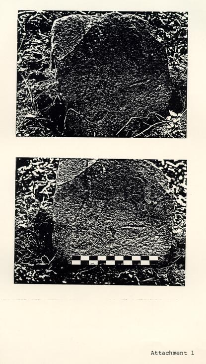 Attachment 1
 Attachment 2
Section of Rochambeau Map showing Property of M. Taylor Area Coincides with Location of Bassett Hall Graves
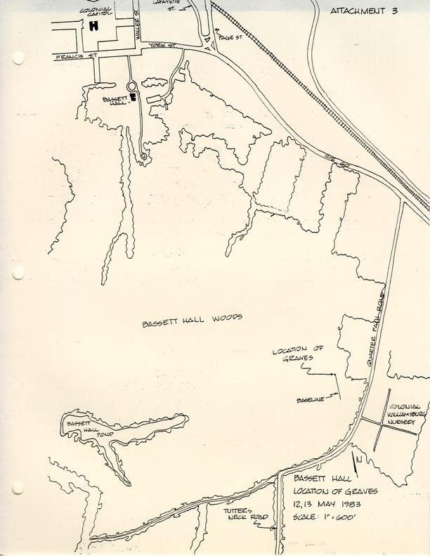 Attachment 3
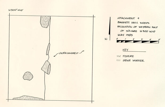 Attachment 4
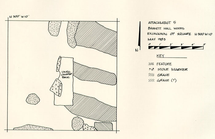 Attachment 5
Bassett Hall Woods Slides
| Slide No. | Description |
|---|---|
| 30-1 | Gravestone in Bassett Hall woods, west of Quarterpath Road. Before excavation. View looking east. |
| 31-2 | Gravestone in Bassett Hall woods, west of Quarterpath Road. Before excavation. View looking east. |
| 32-3 | Gravestone in Bassett Hall woods, west of Quarterpath Road. Before excavation. View looking northwest. |
| 33-4 | Gravestone inscription. |
| 34-5 | Closeup of gravestone inscription. |
| 35-6 | Gravestone inscription. |
| 36-7 | Gravestone inscription. |
| 37-8 | Gravestone inscription. |
| 21-9 | Virginia Caldwell plotting gravestones and features in 10-foot test square. |
| 22-10 | Virginia Caldwell plotting gravestones and features in 10-foot test square. |
| 23-11 | Virginia Caldwell and Jim Csigas plotting gravestones and features in 10 foot test square. |
| 24-12 | Virginia Caldwelll plotting gravestones and features in 10-foot test square. |
| 25-13 | Virginia Caldwell plotting gravestones and features in 10-foot test square. |
| 26-14 | Virginia Caldwell plotting gravestones and features in 10-foot test square. |
| 27-15 | View of two gravestones. One above ground and one broken off at ground level. |
| 28-16 | View of the east half of the 10-foot test square. |
| 29-17 | View of the gravestone inscription with additional inscription at the base. |
| page 2 | |
| 30-18 | View of the gravestone inscription with additional inscription at the base. |
| 31-19 | View of the broken gravestone. With scale. |
| 32-20 | View of two gravestones. With scale and directional arrow. |
| 33-21 | View of two gravestones. With scale and directional arrow. |
| 34-22 | View of two gravestones. With scale and directional arrow. |
| 5-23 | Overhead view of graves, two gravestones, one possible gravestone, post holes, and misc. features. With scale and directional arrow. View looking east. |
| 6-24 | Overhead view of graves, two gravestones, one possible gravestone, post holes, and misc. features. With scale and directional arrow. View looking east. |
| 7-25 | Overhead view of graves, two gravestones, one possible gravestone, post holes, and misc. features. With scale and directional arrow. View looking east. |
| 8-26 | Overhead view of graves, two gravestones, one possible gravestone, post holes, and misc. features. With scale and directional arrow. View looking east. |
| 9-27 | Overhead view of graves, two gravestones, one possible gravestone, post holes, and misc. features. With scale and directional arrow. View looking east. |
| 10-28 | Overhead view of graves, two gravestones, one possible gravestone, post holes, and misc. features. With scale and directional arrow. View looking west. |
| 11-29 | Overhead view of graves, two gravestones, one possible gravestone, post holes, and misc. features. With scale and directional arrow. View looking west. |
| 12-30 | Overhead view of graves, two gravestones, one possible gravestone, post holes, and misc. features. With scale and directional arrow. View looking west. |
| page 3 | |
| 13-31 | Overhead view of graves, two gravestones, one possible gravestone, post holes, and misc. features. With scale and directional arrow. View looking west. |
| 14-32 | Overhead view of graves, two gravestones, one possible gravestone, post holes, and misc. features. With scale and directional arrow. View looking west. |
| 15-33 | Overhead view of graves, two gravestones, one possible gravestone, post holes, and misc. features. With scale and directional arrow. View looking west. |
| 16-34 | Overhead view of graves, two gravestones, one possible gravestone, post holes, and misc. features. With scale and directional arrow. View looking west. |
| 17-35 | Overhead view of graves, two gravestones, one possible gravestone, post holes, and misc. features. With scale and directional arrow. View looking west. |
| 18-36 | Virginia Caldwell in the process of removing fill from around the broken gravestone so that it could be brought into the lab. View looking east. |
| 19-37 | Virginia Caldwell and William Myzk preparing to remove the broken gravestone from the ground so that it could be brought back into the lab. View looking east. |
| 20-38 | Virginia Caldwell and William Myzk preparing to remove the broken gravestone from the ground so that it could be brought back into the lab. View looking east. |
| 21-39 | Virginia Caldwell and William Myzk preparing to remove the broken gravestone from the ground so that it could be brought back into the lab. View looking east. |
PUBLIC INFORMATION
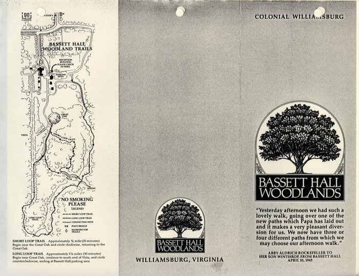
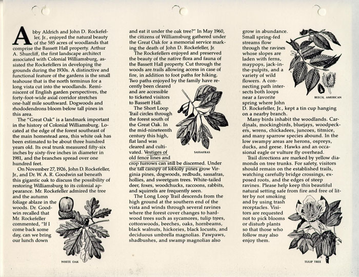
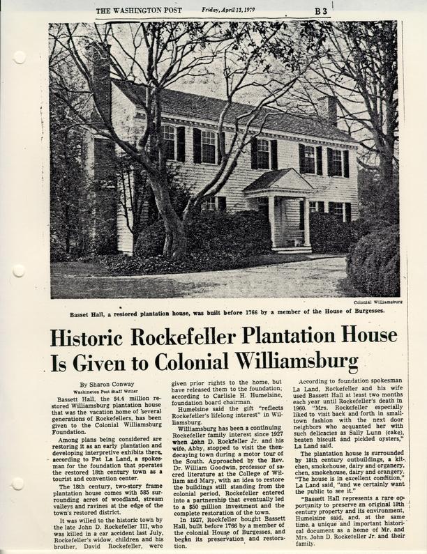


RESEARCH REPORT
January 23, 1951
To: Mr. CampioliFrom: A. P. Middleton
Re: Report on Bassett Hall
Attached herewith is a report on Bassett Hall prepared by Mary A. Stephenson.
A. P. M.
BASSETT HALL
Block #1
LOCATION:
Bassett Hall is located south of Francis Street near the Capitol.
HISTORY:
The well known lots in Williamsburg now called "Bassett Hall," were a part of a large acreage owned by the Bray family in the early eighteenth century. About 1750 the tract comprised about nine hundred and fifty acres in James City County, and four lots in Williamsburg. These lands lay to the south, and southwest of the Capitol; and to the back of Francis Street, adjoining the "Tazewell Hall" tract. A chain to title can be traced to the present time and will be given below.
Although many of the records concerning the property were lost with the destruction of the James City County Records in the Civil War, a few relating to the Bray ownership have survived.
Records of the property from 1751 to 1865 show that the land had become involved in an entailed estate, mortgages and deeds of trust. Records of the entail and the manner of settling the debts of the property owners, are recorded in Hening's Statutes at Large; in the Virginia Gazette; and in manuscript papers at the College of William and Mary.
On November 5th and 6th, 1751, John Blair made the following comment in his Diary:
Mr. Johnson1 has 9 months given him to consider if he will prosecute his appeals agt Judy Bray Ingles,2 2. and agt Col. Bray's1 execrs for the 2 moitys of Nances Neck2 and Tuttys Neck, but this by consent of partys.
6.
(Diary of John Blair, copied from an Almanac 1751, William and Mary Quarterly, Series I., VIII, 14.)
Mr. Johnson's bill in equity against Bray's execrs was red by the court.
A legal disagreement between Colonel Johnson and the other Bray heirs came to a settlement, doubtless, in 1753. In November Philip Johnson came into possession of the tract of 950 acres thereabout known in later years as the "Bassett Hall lands." According to the terms of entail, the land described above should come into possession of James Bray and his male heirs. If James Bray had no sons, then the property was to be divided equally between the heirs of James Bray and the lawful heir of his sister, Ann Inglis, wife of Mungo Inglis. Thomas Bray, James Bray's eldest son, entered the land and died seised of it, leaving no male heir. However, Bray had a daughter, Elizabeth, wife of Philip Johnson. At a General Court in Williamsburg, October 11, 1752, in a chancery suit between Johnson, plaintiff, and Benjamin Waller and William Prentis, defendants, it was ordered by the court that Waller and Prentis convey unto John Robinson3 and his heirs - all the lands and slaves devised to them by Thomas Bray in trust as to one moiety for Philip Johnson during his life, and after his decease to his children. The result: the lands adjoining Williamsburg in James City County and the two lots between the lots of Benjamin Harrison and Benjamin Waller were awarded to Philip Johnson. (See: An Act … concerning lands in James City and lots in Williamsburg in Hening's Statutes, VI, 412-416., copy in Illustration #1.)
3.Johnson's plantation is cited in the Virginia Gazette of date, April 4, 1755:
NOTICE is hereby given;
THAT there is a good Stable and Pasture, with all Sorts of Provinder for Horses, at the Plantation of Philip Johnson , near the Capitol in Williamsburg; where Gentlemen may depend on having proper Care taken of their Horses, Carriages, &c. (Virginia Gazette, Hunter, ed., April 4, 1755.)
There is no mention of a dwelling-house. Neither can the bounds of the plantation be defined. However, from the record (as reported in Hening), it is certain that Johnson's plantation comprised a part of the Bray lands which had come by entail to his wife, Elizabeth Bray Johnson.
In 1758 certain lands of Philip Johnson were vested in John Robinson, in trust:
… Be it therefore enacted, by the Lieutenant-Governor, Council, and Burgesses, of this present General Assembly, and it is hereby enacted, by the authority of the same, That the said seventeen acres and twenty-six poles of land, adjoining the southern bounds of the said city of Williamsburg shall be, and the same are hereby vested in the said Philip Johnson, his heirs and assigns; and that the said forty-three acres of land, with the appurtenances, lying in the said parish of Bruton, and county of James City, late the estate of the said John Baskerfield, shall be, and the same are hereby vested in the said John Robinson, his heirs and assigns, in trust, and to and for the same uses that he is and now stands seized of the residue of the said trust lands.
(An Act for vesting certain lands therein mentioned in Philip Johnson, gentlemen; adding the same to the City of Williamsburg, and for other purposes therein mentioned — Hening's Statutes, VII, 247 ff; Sept. 1758)
It was further enacted by the authority aforesaid "That the said seventeen acres and twenty-six poles of land, so laid off by the said Philip Johnson into [thirty] lots, adjoining the said city of Williamsburg, so soon as the said lot shall respectively be built upon, and saved according to the conditions that shall be contained in the deeds of conveyance thereof, shall be added to and made part of the said city …" (Ibid., 248)
Under the conditions of conveyance, houses of some nature must be 4. built upon the land. Johnson1 was given the nineteen acres and twenty-six poles of land in fee simple; and the forty-three acres of land with the appurtenances… "late the estate of John Baskerfield2 contiguous to the nineteen acres and twenty-six poles were vested in John Robinson in trust … for the uses that he is and now stands seized of the residue of the trust land." (Hening, VII, 453, March 1761.)
By 1766 Johnson had become heavily involved in debt. His houses and lots adjoining Williamsburg were advertised for rent:
June 6, 1766.
TO BE RENTED
THE houses, lots, gardens, stable, and pasture, where I lately lived, adjoining the City of Williamsburg , Any person inclinable to rent them for a year, or term of years, may know the terms by applying to Doctor Hay , or Philip Johnson . (Virginia Gazette, Purdie & Dixon, eds.)
There appeared in the Virginia Gazette of April 14, 1768 the following notice from Johnson:
THIS is to request the favour of all my Creditors to meet me at the brick house of Mr. Gabriel Maupin , in Williamsburg , the second day of next month…
Philip Johnson (Virginia Gazette, Purdie & Dixon, eds.)
As John Robinson, trustee of the lands of Johnson, had died by November, 1769, other trustees were appointed to hold the monies and property. According to Bray's will, Philip Johnson, his son-in-law, would have a life right after the death of his wife, Elizabeth.3 These lands described were:
… one messuage, and three hundred and twelve acres of land, adjoining the city of Williamsburg, except nineteen acres, and twenty-six poles, laid off into lots, and annexed to the city of Williamsburg, by an act made in the first year of the reign of his present majesty … also forty-three acres, purchased by 5. Philip Johnson, gentleman, of John Baskerfield, also of six hundred acres, with the appurtenances, called and known by the name of Tutty's Neck, and also of two lots or half acres of land on Francis street, in the city of Williamsburg, situate between the lots of William Pasteur1 and Benjamin Waller, gentlemen, in trust, as to one moiety thereof for the use of Philip Johnson, gentleman, during his natural life… (Hening's Statutes, VIII, 460-61)
By 1771 Colonel Johnson had rented his house in the city:
WILLIAMSBURG, March 7, 1771.
THE Subscriber begs Leave to acquaint the Gentlemen who favoured him with their Custom that he is now removed to Colonel Johnson's house, behind that of Mr. Waller ; where they may depend upon the best Accommodations for themselves, Servants, and Horses.
RICHARD HUNT SINGLETON. (Virginia Gazette, Purdie & Dixon, eds.)
In the advertisement, Colonel Johnson's house is described as "behind that of Mr. Waller."2 Benjamin Waller's residence was located on Francis Street just below the Capitol. The present Bassett Hall is situated to the southwest of the Waller house; which fact leads one to assume that Philip Johnson had built on the site before 1771. The following notice confirms the above statement:
WILLIAMSBURG, OCTOBER 1, 1771. PURSUANT to a late Act of the General Assembly, which hath received the Royal Assent, we propose to sell to the highest Bidders, on Thursday the 31st Instant, at four o'Clock in the Afternoon, before Mr. Southall's door, in this City, the DWELLING-HOUSE, OUTHOUSES, GARDEN, and PASTURE, where Colonel Philip Johnson formerly lived, now in the Tenure of Mr. Richard Hunt Singleton ; also the Remainder of the same Tract of LAND Adjoining the City of Williamsburg , with two LOTS on Francis Street between the LOTS of Mr. Waller and Doctor Pasteur ; the whole to be disposed of together, or in Parcels, as may best suit the Purchasers. At the same time will be sold a Tract of LAND called Tutty's Neck, containing about six Hundred Acres, more or less, very convenient to the City of Williamsburg, whereon are all necessary Houses for Cropping. Two Years Credit will be allowed the Purchasers upon their giving Bonds, with approved Security, payable with Interest from the 6. Dates.
Trustees.
(Virginia Gazette, Purdie & Dixon, eds., Oct. 31 1771.)
PEYTON RANDOLPH
RO. C. NICHOLAS
LEWIS BURWELL
PHILIP W CLAIBORNE
In this notice the property of Colonel Johnson is clearly defined: two lots on Francis Street, a dwelling and outbuildings, and about six hundred acres called "Tutty's Neck," and the remainder of the dwelling-house tract.
Another notice from the Trustees of Johnson's property sheds light on the situation:
WILLIAMSBURG,
November 21, 1771.
THE Trustees, not thinking it proper to proceed on the Sale of Colonel Philip Johnson's Land, near this City, on the 31st of October , last, according to their former Advertisement, without an exact Survey of the valuable Tract called Tutty's Neck, and having the Land contiguous to the Town laid out in small Parcels, nor, give Notice that they intend to sell those lands on Tuesday the 10th of December , at four o'Clock in the Afternoon, before Mr. Southall's Door; when the plan of the Survey and Division will be shown to any who are inclined to buy. The Purchasers will be allowed two years Credit; and it is expected they are to give Bonds, with unexceptionable Securities, which are to carry Interest from the Time they bear Date.
Trustees.
PEYTON RANDOLPH
RO. C. NICHOLAS
LEWIS BURWELL
PHILIP W CLAIBORNE (Virginia Gazette, Purdie & Dixon, eds.)
Though effort had been made by the Trustees, no sale had been completed in January , 1772. Singleton was, apparently, renting the Johnson property:
WILLIAMSBURG,7.
January 27, 1772.
THE Subscriber begs Leave to inform the Publick that he still continues to occupy the House, on the South Side of the Capitol, where the Gentlemen Burgesses may depend upon the best Treatment, on the most reasonable Terms, from
Their very humble Servant,
RICHARD SINGLETON.
N.B. Good stables, Pastures, &c. (Virginia Gazette, Purdie & Dixon, eds.)
The dwelling-house of Colonel Johnson had not been sold in April, 1773:
To be SOLD, on Friday the 30th Instant (April) at five o'Clock in the Afternoon, before Mr. Southall's Door , in Williamsburg,
The Dwellinghouse, Outhouses, Lots, and Pasture, where Colonel Philip Johnson formerly lived, in this City. The Commodiousness of their Situation need not be described, as it is so well known. Any Person inclining to purchase may in the mean Time treat with Peyton Randolph and Robert Carter Nicholas , Esquires. The tenement may be entered upon immediately, and the Purchaser, will have Credit till next Christmas , paying Interest from the Day of Sale, and giving Bond, with approved Security. (Virginia Gazette, Purdie & Dixon, eds.)
In October, 1773, Colonel Johnson was serving as justice of James City County. (Ibid.) A runaway who was the property of Johnson had been hired to Thomas Skinner by the trustees for almost four years. In October 1774, Skinner sent notice that he suspected that the runaway was harbored at one of Johnson's quarters. The trustees of Johnson's property were still in power at this date.
Colonel Johnson resigned in 1776 as county lieutenant of James City on account of age and infirmaties. (Journal of the Council of Virginia, I, 254.) He had served also as a member of the committee of safety. (William and Mary Quarterly, V, 104.)
The property of Johnson had not been sold in 1777.1 Effort was still being made by the trustees to pay creditors: 8.
WILLIAMSBURG,
February 26, 1777.
THE Trustees of Col. Philip Johnson being anxious to settle his Affairs, and having good Prospect of paying in a short time, the Demands of such of his Creditors as acceded to the Deed of Trust, desire a meeting of those Creditors at the House of Mr. James Southall in this city, on Thursday the 13th of March next. If any of them should be unable to attend, they are requested to send their claims properly stated. All those indebted to the Trust Estate for the Hire of Negroes, or other wise, are desired to make immediate Payments to Mr. John Watkins of King William County, who will attend here the same Day. No indulgences can be given .
THE TRUSTEES. (Virginia Gazette, Dixon & Hunter, eds.)
On the Galt Map (1780?) Johnson's land lies to the east of Tazewell Hall. On Rochambeau's Map (1782) of this area, Johnston's Mill1 is situated to the southeast of King's Mill. On the Frenchman's Map (1782) the dwelling house, rectangular in shape with rear wing, is placed about 400 feet from street [Francis street]. There are three out-buildings about 50 feet to the rear, and 2 out-buildings in right-rear and left-rear about 25 feet and 350 feet, respectively, from the dwelling. The dwelling sets about 500 feet from the Waller house. A rectangular-shaped yard is about 400 feet by 200 feet with a small building in the northwest corner on the street. The outbuildings are not inclosed in the 250 by 200 feet area. (See: architect's drawing from the Frenchman's Map, Illustration #3) Also included in illustration #3 is an archaeological report by Herbert S. Ragland, 1932, concerning the old foundations found on the property.
The land tax records for James City County indicate that Philip Johnson paid taxes in 1787 on 204 acres of land at 9/8 per acre; valued at $98.12. (Illustration #2)
In December 1788, it became necessary to appoint other trustees 9. of the Johnson property. (Hening's Statutes, XII, 716-17)
On March 19, 1789 the newspaper reported the death of Colonel Johnson:
DEATHS. Departed this life on the 15th Instant Mr. PHILIP JOHNSTON [Johnson?] of James City county. (Virginia Gazette & Weekly Advertiser, Nicholson ed.)
The College Map (1791?) shows Johnson's land to the east of Tasewell's [Tazewell Hall] and south of Hubbard, Waters, Bassett and the Corporation lots. See also Bucktrout Map (1803) for locations. (Research Department has copies of these maps.)
Several deeds to adjoining property around 1800-1806 as well as insurance policies of the Mutual Assurance Society on the Semple property, indicate that Burwell Bassett1 had become the owner of Philip Johnson's lots and lands in and adjoining Williamsburg. A deed from Lewis Saunders to Littleton Tazewell located Bassett on the land formerly owned by Johnson: "…The greater tract by the lands of Burwell Bassett, by those of Littleton Tazewell, by those of Gabriel Maupin decd, and by the Creek which heads near Southall's Mills … being the tract of which the said John Saunders … died intestate, sometime in the year 1793 …" (Southall Papers, College of William and Mary.) In 1806 an insurance policy of James Semple's gives Burwell Bassett's lot adjoining Semple. (Copy of policy in Research Department.)
The Williamsburg land tax records for 1804 and 1810 give Bassett as owner of 2 lots valued at $20 and $10 respectively. From 1812 to 1820 Bassett is listed as possessing 6 lots valued at $30. From 1820 to 1838 Bassett whose residence is given as "James City," is owner of "l lot in Williamsburg valued at $75." (Illustration #2 for complete records.)
10.The lot listed in the land tax list above, doubtless, was the entrance lot to Bassett Hall by way of Francis Street. From the fact that owners of Bassett Hall paid taxes on lots in the city (adjoining Waller's lots on Francis Street), it seems reasonable to state that such land was used as an entrance park to the Bassett Hall dwelling-house lot.
During 1836-42 a correspondence relating to Bassett Hall property was carried on between Abel P. Upshur1 of "Vaucluse," eastern shore of Virginia, and Judge Beverley Tucker of Williamsburg. From these letters one finds that Upshur became the owner of Bassett Hall on May 5, 1840. (Illustration #5, copies of letters dated Dec. 4, 1840; January 27, 1840; April 5, 1840 and November 28, 1840.)
The property was acquired in 1843 by John Coke. The Land Tax Records give: "1 lot including buildings $2550 via Abel P. Upshur — See an act of Assembly passed, 31st January 1843, which, by extending the limits of the city, a small slip of land theretofore taxed to Colo. Bassett's estate becomes merged in the property purchased by Mr J. Coke of the Hon. Ap. Upshur, who purchased of Galt who purchased of Bassett."
Coke held the property until November 18, 1845 when it was conveyed to Goodrich Durfey. In 1850 Durfey was charged in the land book with "l lot valuations with buildings $2550. Formerly ded to John Coke." Durfey in 1861 was charged with "l lot valued at $3500." (Illustration #2)
Several maps have come to light giving Bassett Hall tract with adjoining lots. One with date on the back, "1868", is of exceptional interest as to locations of houses and farming area. In the lower corner of the map one finds: "Plot of Col Durfeys house tract after cutting of 60.2 & some 11. perches for Mr. Lefelver & contains 381..3..28 perches[,] Map endorsed A on back, by Sidney Smith Trustee and referred to in deed of Z. G. Durfey to Israel Smith. Cut the cloth where paper is slipped under." On the back of the map the following is written: "B This is the plot referred to in the deed from Z. G. Durfey to Israel Smith, executed 15th Decbr 1868, S. Smith sub Trustee." Upon examination of the map one sees a large plat southeast of the dwelling and to the rear of the Waller dwelling marked, "Land sold by Col. Durfey to Mr Lyons." From a study of the map above described, we know that Durfey retained as his dwelling house tract the 85 acres with avenue leading into Williamsburg via Francis Street. (Illustration #3 for copy)
Another map1 with no date is now in the Research Department. It is a colored map of Bassett Hall and surrounding lands. The dwelling is drawn as rectangular with rear wing, facing upon a 2-acre lawn. A circular drive-way is shown in front of the house and a road leads out to Francis Street and to the farm lots in the rear of the dwelling-house. Dr. Morris is noted as the occupant of the Benjamin Waller lot; J. W. Custis3 and Wooden to the west. Farm lands, gardens, orchards, barns, ice house, hog pen, cow yard, pasture - all show on the map to the rear of the dwelling. (Illustration #3 for photostat)
In 1865 the court records of Williamsburg and James City County were destroyed by fire. Only one Deed Book (1854) was saved from destruction. From this book it is possible to trace the title to Bassett Hall.
Upon the death of Durfey in 1869 the property was conveyed to Israel Smith.
12.The chain to title as prepared by Mr. Channing Hall for Dr. W. A. R. Goodwin, 1927, can be found in Illustration #4. Dr. Goodwin was representing the interests of Colonial Williamsburg Restoration in securing the property from the owners at that time.
IN SUMMARY:
Bassett Hall comprises a part of that large tract once the property of the Bray family. By marriage to Elizabeth Bray, daughter of Thomas Bray, the lands came into the possession of Colonel Philip Johnson about 1753. The plantation of Philip Johnson is cited in the Virginia Gazette of April 4, 1755 as "near the Capitol in Williamsburg." However, there is no mention of a dwelling-house in this notice. In 1766, "the houses and lots of Johnson adjoining the City of Williamsburg," were advertised to be rented. The Virginia Gazette describes Johnson's property as "the houses, lots, garden, stable and pasture, where I lately lived." By 1771, Johnson had rented his house to Richard Hunt Singleton. Singleton advertised that "The Subscriber begs Leave to acquaint the Gentlemen who favoured him with their Custom that he is now removed to Colonel Johnson's house, behind that of Mr. Waller." (The reference is to Benjamin Waller whose house was on Francis Street just below the Capitol.) An effort was made to sell Johnson's property in October and November, 1771, but no sale was consummated by the trustees until after Johnson's death in March, 1789. On the Frenchman's Map of Williamsburg (1782) the dwelling-house, rectangular in shape with a rear wing, is placed about 400 feet from a street to the north. There are three out-buildings about 50 feet to the southeast, and one to the southwest. Another small building is about 350 feet to the south. A rectangular shaped yard upon which the house faces is about 400 feet by 200 feet with a small building in the northwest corner. The College Map (1791?) indicates "the 13. lands of Philip Johnson" in this area, as does the Bucktrout Map (1803). Several deeds between 1800-1806 and an insurance policy to bordering property, show that Burwell Bassett [of Eltham] had come into the lots and lands of Philip Johnson; and the Williamsburg Land Tax records give Bassett as owner of "2 lots valued at $20 and $10" respectively. From 1820-38 Bassett appears as owner of "l lot valued at $75." In 1840, Abel P. Upshur of "Vaucluse," eastern shore of Virginia, became the owner of Bassett Hall. In 1843, the records show that John Coke was the owner of "l lot valued including buildings at $2550 via Abel P. Upshur." In 1845, Goodrich Durfey became the owner of "l lot valued at $2550 including buildings. Formerly ded to John Coke." In 1869 the property was conveyed to Israel Smith by the executor of Goodrich Durfey. From a study of a map by S. Smith (dated 1868) one sees that Durfey during his tenure, retained as his dwelling-house tract the 85 acres with avenue leading into Williamsburg via Francis Street, and sold other lands adjoining. Another map (no date, but possibly 1869) is a colored map of Bassett Hall and surrounding lands. The dwelling is drawn as a rectangular building with rear wing, facing upon a 2-acre lawn. A circular drive is shown in front of the house, and a road leads out to Francis Street north and the farm lots to the south. Though court records of Williamsburg and James City County were largely destroyed by fire in 1865, one deed book was saved and from this record it is now possible to trace the title to Bassett Hall from Israel Smith's ownership to the present time. Further title to the property as prepared by Channing Hall for Dr. W. A. R. Goodwin representing the Restoration interests in 1927, can be found in Illustration #4, Appendix.
14.| Illustration #1 | Abstracts from Hening's Statutes of Virginia |
| Illustration #2 | Williamsburg Land Tax Records |
| Illustration #3 | Maps and Archaeological Reports |
| Illustration #4 | Abstracts to Title |
| Illustration #5 | Historical Material, letters &c. |
| Illustration #6 | List of pictures on file of Bassett Hall |
Report prepared by Mary A. Stephenson
Typed by L.N.M. January 1951
Illustration #1
Hening
STATUTES AT LARGE
VI, 412-416An Act for establishing an agreement made between Philip Johnson, and William Armistead, gentlemen.
WHEREAS David Bray the elder, late of the parish of Wilmington, in the county of James City, gentleman, deceased, in his lifetime, and at the time of his death, was seised in fee-simple, of, and in four lots of land in the city of Williamsburg, and several tracts or parcels of land, in the said county of James City, containing by estimation nine hundred and fifty acres, or thereabouts, and of, and in another tract or parcel lying in the county of Charles-City, containing by estimation, eighteen hundred and fifty acres or thereabouts, known by the name of Nance's Neck; and being so seised, by his last will and testament in writing, bearing date the twenty first day of October, one thousand seven hundred and seventeen, devised all his lands to David Bray his son, and declared his will and meaning to be, that if his said son David should live till he came to the age of twenty one years, and should not have issue of his body lawfully begotten, he should not sell or dispose of any of the said lands, until he had such issue; but if he should live to have such issue of his body, and attain the age of twenty one years, if both the things should happen, he gave his said son all his lands to him and his heirs forever; but in case he should die, before he had lawful issue, he gave all his said lands to his brother James Bray, and the heirs male of his body lawfully begotten, and in default of such issue, declared his will to be, that his said lands should be equally divided between the heirs of his said brother James Bray, and the lawful heir of his late deceased sister, Ann Ingles, late wife of Mungo Ingles, as by the said will, recorded in the court of the said county of James-City, may, among other things appear. And after the death of the said David Bray the father, the said David Bray the son, entered into the said lands, and died seised thereof, without issue of his body; and the said testator's brother James Bray in the said will named died, leaving issue Thomas Bray, his eldest son, and heir male of his body, who after the death of the said David Bray the son, entered into the said lands, and died seised thereof, without heir male of his body, leaving a daughter named Elizabeth, then and now the wife of Philip Johnson, of the county of King and Queen, gentleman, having first made his last will and testament in writing, bearing date the seventh day of May, one thousand seven hundred and fifty one, and thereby devised the remainder in fee-simple, of one moiety of the said lands to Benjamin Wallers and William Prentis , gentleman, in trust, to, and for several uses in the said will mentioned, as by the said will remaining of record, in the court of the said county of James City, may among other things appear. And whereas one Judith Bray Ingles, was heir at law of the said Ann Ingles, the sister of the said David Bray the father, and named in his will, and is intitled to the other moiety of the said lands, and hath lately married one William Armistead, gent. And whereas at a general court, held at the court-house in Williamsburg, the eleventh day of October one thousand seven hundred and fifty two, in a suit in chancery, between the said Philip Johnson, plaintiff, and the said Benjamin Waller, and William Prentis, defendants, it was decreed and ordered by the said court, 2 that the said Benjamin Waller, and William Prentis, should convey unto John Robinson, esquire, all the lands and slaves devised to them by the said Thomas Bray, to hold to the said John Robinson, his heirs and assigns, in trust, as to one moiety thereof, to, and for the use of the said Philip Johnson, during his natural life, and after his decease, in trust, to, and for the use of such child, or children, as the said Philip then had, or might thereafter have by the above-named Elizabeth, his wife, to whom he should give or devise the same; by his deed, will, or other instrument in writing, duly made and executed, and to his, her or their heirs and assigns forever; subject nevertheless, to the dower of the said Elizabeth therein; and as to the other moiety in trust, to and for the use of the said Philip Johnson, his heirs and assigns forever, in case he shall pay unto such child or children, of him and the said Elizabeth, all and every such sum and sums of money, as the said Elizabeth, notwithstanding her coverture, shall by any deed or instrument [sic] in writing, duly executed by her, give, direct and appoint, according to a proviso and his covenant, contained in a certain indenture of release: But in case the said Philip Johnson, shall not pay such sum of money, then in trust, to and for the use of such child or children aforesaid, to whom the said Elizabeth, by such deed or instrument in writing, shall give, direct and appoint the same: And in case the said Elizabeth, shall execute no such deed or instrument, then in trust to and for the use of the said Philip Johnson, during his natural life, and after his decease, in trust, and to, and for the use of such child or children as the said Philip Johnson then had or might thereafter have by the said Elizabeth, to whom he shall give or devise the same, by his deed or will as aforesaid, and to the heirs and assigns of such child or children forever; subject nevertheless to the dower of the said Elizabeth, therein, as by the record and proceedings of the said suit in chancery, remaining in the general court aforesaid may among other things appear: And the said Benjamin Waller, and William Prentis, have accordingly conveyed to the said John Robinson, and his heirs, the said lands and slaves in trust, and to, and for the several uses in the said decree mentioned. And whereas in case partition shall be made of the said lands, between the said Philip Johnson and Elizabeth his wife, and the said William Armistead and Judith Bray, his wife, the value of the said lands will be considerably diminished, and it will be more beneficial to all parties claiming the same, if they shall remain entire; and the said Philip Johnson, and William Armistead, have agreed, that all the said tract of land known by the name of Nance's neck, with the appurtenances, and two of the said lots of land, adjoining the lots of Dudley Digges, gentleman, and James Spiers, in Francis-street, in the said city, shall be vested in the said William Armistead, and Judith Bray his wife, and the heirs of the said Judith Bray; to hold to them in the same manner, and for the same estate, as they would have had and held the moiety thereof, if this act had not been made: And that the other two lots of land lying in the said street, between the lots of Benjamin Harrison, gentleman, and the said Benjamin Waller, and all the said tracts or parcels of land in the county of James City aforesaid, with the appurtenances, shall be vested in the said John Robinson, to hold to him, his heirs and assigns in trust, and to and for the same uses, and in the same manner, as the said John Robinson and his heirs would have had and held one moiety thereof, if this act had not 3 been made: And that the said William Armistead shall pay to the said John Robinson the sum of three hundred and ninety pounds, the value of one moiety of the said tract of land, known by the name of Nance's neck, more than the value of the said tracts or parcels of land in the said county of James City, to be laid out by the said John Robinson in purchasing slaves, to be held by him in trust, to and for the same uses, and in the same manner, as the lands and slaves conveyed to him by the said Benjamin Waller and William Prentiss, as aforesaid, which agreement the said Judith Bray, the wife of the said William Armistead, and the said Elizabeth, the wife of the said Philip Johnson, are willing to have confirmed.
II. BE it therefore enacted, by the Lieutenant Governor, Council, and Burgesses, of this present General Assembly, and it is hereby enacted, by the authority of the same , That the agreement above mentioned between the said parties, be, and is hereby confirmed and established, and shall forever hereafter be valid and binding between them and their heirs, and all others claiming under them. And that all the aforesaid tract of land, known by the name of Nance's neck, and every part thereof with the appurtenances, and the said two lots of land adjoining the lots of the said Dudley Digges and James Spiers, shall be, and the same are hereby vested in, and shall be held, possessed and enjoyed by the said William Armistead, and Judith Bray his wife, and her heirs, and they shall be seised thereof in the same manner, and of, and in the same estate, as they would have had, held, and been seised of, in the one moiety thereof, if this act had not been made. And that all the aforesaid tracts or parcels of lands, in the said county of James City, with the appurtenances, and the said two lots of land, lying between the lots of the said Benjamin Harrison, and Benjamin Waller, shall be, and the same are hereby vested in, and shall be held by the said John Robinson, his heirs and assigns, and he, and they shall be seised of the same, in the same manner, and of, and in the same estate, and in trust, and to, and for the same uses as the lands and slaves conveyed to him the said John Robinson, by the said Benjamin Waller, and William Prentis as aforesaid; and that the said John Robinson, his heirs, executors, and administrators, after the above mentioned three hundred and ninety pounds shall be paid to him or them, shall lay out the same in purchasing slaves, and the said John Robinson, his heirs, executors, and administrators, shall hold and be possessed of such slaves so to be purchased, in trust, and to, and for the same uses as the lands and slaves conveyed to him by the said Benjamin Waller, and William Prentis, as aforesaid, a list of the names of which slaves shall be, by the said John Robinson, returned to the court of the said county of James City, there to be recorded.
III. Saving to the king's most excellent majesty, his heirs and successors, and every other person and person, bodies politic and corporate, their respective heirs and successors, all such right, title, estate, interest, claim and demand, of, in, or to either of the above mentioned tracts of land, other than the persons claiming under the said Judith Bray, the wife of the said William Armistead, and the last will and 4 testament of the above named Thomas Bray, or either of them, as they, every, or any of them should or might claim, if this act had not been made.
(Hening, Statutes at Large, VI, 412-416)
Illustration #1
Hening
STATUTES AT LARGE
VII, 247-48, Sept. 1758An Act for vesting certain lands therein mentioned in Philip Johnson, gentleman, adding the same to the City of Williamsburg, and for other purposes therein mentioned.
WHEREAS John Robinson, esquire, is and stands seized of divers lands and tenements, in the parish of Bruton, in the county of James-City, in trust, as to one moiety thereof for the use of Philip Johnson, gentlemen, during his natural life, and after his decease, in trust, and to and for the use of such child or children as he now hath or may have by Elizabeth his present wife, daughter of Thomas Bray, gentleman, deceased, to whom he shall give or devise the same by deed or will, subject nevertheless to the dower of the said Elizabeth; and as to the other moiety thereof, in trust, and to and for the use of the said Philip Johnson, his heirs and assigns for ever, in case he shall pay unto such child or children of him and the said Elizabeth all and every such sum and sums of money as the said Elizabeth, notwithstanding her coverture, shall, by any deed or instrument in writing, duly executed by her, give, direct, and appoint, according to the proviso; and his covenant contained in an indenture of release, bearing date the twenty-second day of October, one thousand seven hundred and fifty-one, made between the said Philip Johnson and Elizabeth his wife, of the one part, and the said John Robinson of the other part, which indenture is now remaining on record in the secretary's office, but in case he shall not pay such money, then in trust, and to and for the use of such child or children, as aforesaid, to whom the said Elizabeth, by such deed or instrument in writing, shall give, direct, and appoint the same; and in case the said Elizabeth shall execute no such deed or instrument, then in trust, and to and for the use of the said Philip Johnson, during his natural life, and after his decease, in trust, and to and for the use of such child or children as the said Philip Johnson now hath or hereafter may have by the said Elizabeth, to whom he shall give or devise the same by deed or will as aforesaid, and to the heirs and assigns of such child or children, subject nevertheless to the dower of the said Elizabeth.
II. And whereas it hath been represented to this general assembly by the said Philip Johnson, That he hath laid off seventeen acres and twenty-six poles of the said trust land, adjoining the southern bounds of the city of Williamsburg, into thirty lots, which he is desirous may be added to and made part of the said city: And the said Philip Johnson being seized in fee-simple of forty-three acres of land, with the appurtenances, late the estate of one John Baskerfield, lying in the said parish of Bruton, and county of James City, contiguous to the said trust lands, and of greater value than the said seventeen acres and twenty-six poles so laid off into lots, which he is willing should be settled in lieu thereof: Be it therefore enacted, by the Lieutenant-Governor, Council, and Burgesses. of this present General Assembly, and it is hereby enacted, by the authority of the same , That the said seventeen acres and twenty-six poles of land, adjoining the southern bounds of the said city of Williamsburg, shall be, and the same are hereby vested in the 2 said Philip Johnson, his heirs and assigns; and that the said forty-three acres of land, with the appurtenances, lying in the said parish of Bruton, and county of James-City, late the estate of the said John Baskerfield, shall be, and the same are hereby vested in the said John Robinson, his heirs and assigns, in trust, and to and for the same uses that he is and now stands seized of the residue of the said trust lands.
III. And be it further enacted, by the authority aforesaid , That the said seventeen acres and twenty-six poles of land, so laid off by the said Philip Johnson into lots, adjoining the said city of Williamsburg, so soon as the said lots shall respectively be built upon, and saved according to the conditions that shall be contained in the deeds of conveyance thereof, shall be added to and made part of the said city; and the free-holders and inhabitants of the said lots shall then be entitled to, and enjoy all the rights, privileges, and immunities granted to and enjoyed by the freeholders and inhabitants of the said city, and shall be subject to the same jurisdiction, rules, and government with the other inhabitants of the said city.
Illustration #2
| 1787 | Johnson, Philip | 204 acres | 9/8 pr. acre | Value $98.12 | Tax 1.9.7 |
| 1813 | Bassett, Burwell | 355 acres | $1015.05 | Tax $6.49 | |
| Bounded By Williamsburg Stage Road on N. the Road to King's Mill on the E Tutters Neck Mill run & Saunders tract on the S & Littleton Tazewells on the W. | |||||
| value land | Total value land and buildings | ||||
|---|---|---|---|---|---|
| 1819 | Bassett, Burwell | 335 acres | $1746 | $5849.10 | Tax $7.32 |
| Bounded by Wmsburg Stage road N Road to King's Mill E Tuttie's Neck mill and Saunders Tract S & SW and Tazewell's Este W ¾ SE from Court House | |||||
| 1820 | Bassett, Burwell | 335 acres | $1746 | $5849.10 | Tax $5.27 |
| Bounded by Wmsburg Stage road N Road to King's Mill e Tuttie's Neck mill and Saunders Tract S & SW and Tazewell's Este W ¾ SE from Court House | |||||
| 1822 | Bassett, Burwell | 335 acres | $1746 | $5849.10 | Tax $5.27 |
| Bounded by Wmsburg Stage road N Road to King's Mill e Tuttie's Neck mill and Saunders Tract S & SW and Tazewell's Este W ¾ SE from Court House | |||||
| 1826 | Bassett, Burwell | 335 acres | $1746 | $5849.10 | Tax $5.27 |
| Bounded by Wmsburg Stage road N Road to King's Mill e Tuttie's Neck mill and Saunders Tract S & SW and Tazewell's Este W ¾ SE from Court House | |||||
| 1828 | Bassett, Burwell | 335 acres | $1746 | $5849.10 | Tax $5.27 |
| Bounded by Wmsburg Stage road N Road to King's Mill E Tuttie's Neck mill and Saunders Tract S & SW and Tazewell's Este W ¾ SE from Court House | |||||
| 1829 | Bassett, Burwell | 335 acres | $1746 | $5849.10 | Tax $5.27 |
| Bounded by Wmsburg Stage road N Road to King's Mill e Tuttie's Neck mill and Saunders Tract S & SW and Tazewell's Este W ¾ SE from Court House | |||||
| 1830 | Bassett, Burwell | 335 acres | $1746 | $5849.10 | Tax $5.27 |
| Bounded by Wmsburg Stage road N Road to King's Mill e Tuttie's Neck mill and Saunders Tract S & SW and Tazewell's Este W ¾ SE from Court House | |||||
| 1832 | Bassett, Burwell | 335 acres | $1746 | $5849.10 | Tax $5.27 |
| Bounded by Wmsburg Stage road N Road to King's Mill e Tuttie's Neck mill and Saunders Tract S & SW and Tazewell's Este W ¾ SE from Court House | |||||
| 1834 | Bassett, Burwell | 335 acres | $1746 | $5849.10 | Tax $5.27 |
| Bounded by Wmsburg Stage road N Road to King's Mill e Tuttie's Neck mill and Saunders Tract S & SW and Tazewell's Este W ¾ SE from Court House | |||||
| 1835 | Bassett, Burwell | 329 acres | $2500 | $5789.24 | Tax $4.63 |
| James City | by stage Road N King's Mill Road E Tutters Neck Mill & Saunder tract S & by Litt: W. Tazewell's Est. W. ¾ miles S. E. of Court House | ||||
| Note: 6 acres taken from the tract & ch. to Richd M. Bucktrout | |||||
| 1837 | Bassett, Burwell | 329 acres | $2500 | $5789.24 | Tax $4.63 |
| James City | by Stage Road N King's Mill Road E Tutters Neck Mill & Saunders tract S & by Litt: W. Tazewell's Est. W ¾ miles S. E. of Court House | ||||
| Note: 6 acrs taken from the tract & ch. to Richd M. Bucktrout |
| 1801 | Burwell Bassett | 2 lots | $20 | ||
| 1806 | Burwell Bassett | 2 lots | $20 | ||
| 1807 | Burwell Bassett | 2 lots | $10 | ||
| 1809 | Burwell Bassett | 2 lots | $10 | ||
| 1810 | Burwell Bassett | 2 lots | $10 | ||
| 1811 | Burwell Bassett | 2 lots | $10 | ||
| 1812 | Burwell Bassett | 6 lots | $30 | ||
| 1814 | Burwell Bassett | 6 lots | $30 | ||
| 1817 | Burwell Bassett | 6 lots | $30 | ||
| 1818 | Burwell Bassett | 6 lots | $30 | ||
| 1819 | Burwell Bassett | 6 lots | $30 | ||
| 1820 | Burwell Bassett | 1 lot | $75 | James City, Residence | |
| 1825 | Burwell Bassett | 1 lot | $75 | " " " | |
| 1828 | Burwell Bassett | 1 lot | $75 | " " " | |
| 1830 | Burwell Bassett | 1 lot | $75 | " " " | |
| 1831 | Burwell Bassett | 1 lot | $75 | " " " | |
| 1835 | Burwell Bassett | 1 lot | $75 | " " " | |
| 1838 | Burwell Bassett | 1 lot | $75 | " " " | |
| 1840 | Burwell Bassett | 1 lot | $100 | New Kent, Residence | |
| 1841 | Burwell Bassett | Est. 1 lot | $100 | [Value incl. bldgs.] $2550 | |
| 1842 | Burwell Bassett | Est. 1 lot | $100 | ||
| 1843 | Coke John | 1 lot | $2550 | via Abel P. Upshur — See an Act of Assembly passed, 31st January 1843, which, by extending the limit of the city, a small strip of land theretofore taxed to Colo. Bassett's estate becomes merged in the property purchased by Mr J. Coke of the Hon. A. P. Upshur, who purchased of Galt who purchased of Bassett James City County | |
| 1847 | Coke John | 1 lot | $2550 | ||
| 1850 | Durfey, Goodrich | 1 lot | $2550 | — Formerly chgd to John Coke | |
| 1852 | " " | 1 lot | $3300 | ||
| 1854 | Durfey, Goodrich | 1 lot | $3300 | ||
| 1856 | " " | 1 lot | $3300 | ||
| 1857 | " " | 1 lot | $3500 | ||
| 1859 | Durfey, Goodrich | 1 lot | $3500 | ||
| 1861 | Durfey, Goodrich | 1 lot | $3500 |
Illustration #3
| 1749 | Waller Map |
| "Col. Brays Land" to south of "Mr. Waller's Pasture" also "Col. Thomas Brays 2 Lotts" adjoin "Mr. Benjamin Wallers Lot." (See Research Department files.) | |
| 1780 | Browne Map |
| To the east of Tazewell Hall lies "Col. Philip Johnson's Land." This land is to the south of lots 18-34. East of these lots were "Col. Phil. Johnson's Lots Annext to the City. 19 acres and 26 poles laid off into lots as above" These 19 acres were immediately south of the Semple, Bassett and Waller lots on Francis Street. (See Research Department files.) | |
| 1782 | Frenchman's Map |
| On the Frenchman's Map a house shaped [small drawing] is located about 400 feet from 2nd Street [Francis Street] with 3 out-buildings about 50 feet to the rear, and 2 out-buildings in rear to right and left some 250 feet from the dwelling house. The dwelling house is pictured about 500 feet from the Waller dwelling house on Francis Street. The rectangular-shaped lot upon which the house apparently faces, is about 400 feet by 200 feet with a small building in the northwest corner. The out-buildings to the rear of the dwelling house are not inclosed in the area of the dwelling, but are inclosed in an area about 250 feet by 200 feet. | |
| (See copy of map in Appendix , Illus. #3.) | |
| 1782 | Rochambeau Map |
| Johnston's Mill located to southeast of the Capitol; Saunders tract to the south of Williamsburg near College Landing (of value in Bassett history); King's Mill to the south of Capitol. (See Research Department files.) | |
| 1791 | (?)College Map |
| Col. Philip Johnson's Land to the east of Tazewell Hall and south of Hubbard, Waters, and Bassett. Also south of Corporation lots. There are "19 acres and 26 poles of Johnson's land to the east of these lots laid off into lots, and annext to the city" These 19 acres are to the south of the Semple and Bassett lots on Francis Street across from the Capitol. | |
| (See copy of map in Appendix Illust. #3.) | |
| 1803 | (?)Bucktrout Map |
| Col. Philip Johnson's Land to the east of Tazewell Hall and south of the Waters, Hubbard, Bassett, and Corporation lots. The 19 acres and 26 poles of Col. Phillip Johnson's Lots attached to the City laid off into Lots as above. These lots are to the south of the Semple, Bassett and Waller lots. | |
| (See Research Department files.) | |
| 1818 | Ladd Map |
| A Plan of that Part of the Virginia Canal from College Creek to Williamsburg — 1 mile and 22 poles and 20 links, — Tazewell Meadow, and Delk's Land. | |
| (See Research Department files.) | |
| 1868 | Map endorsed A on back by Sidney Smith Trustee [Dec. 15, 1868, date on back Plot of Col Durfeys house tract — Drawings of Waller house, Waller graveyard, Bassett Hall house to southwest, long avenue, gateposts. |
| no date [1868 probably] | Colored Map |
| Bassett Hall house drawn [rectangular with rear wing] facing upon a 2 acre lawn; Dr. Morris's [Waller house to the northeast; graveyard to the rear of Morris house; J. W. Custis lot to the northwest; gardens and orchards to rear; barn, ice house, hog pen, etc. See map for details. (Appendix , Illus. #3.) | |
 Bassett Hall and Outbuildings
 Photostat copy of Williamsburg Plat in "Williamsburg the Old Colonial Capitol" by Lyon G. Tyler
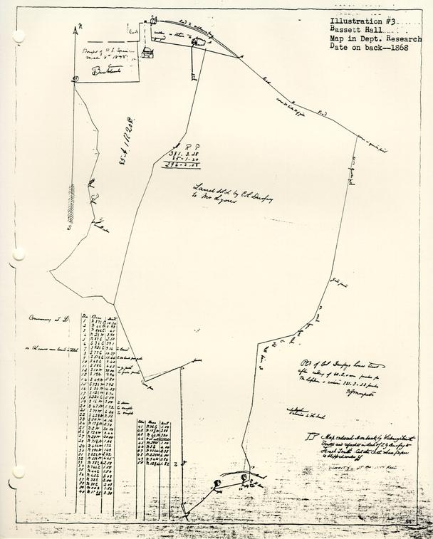 Bassett Hall Map in Dept. of Research
 From Colored Map Bassett Hall
Illustration #4
BASSETT HALL
AN ABSTRACT OF TITLE made October 26, 1927, by C. M. Hall, Attorney at Law of Williamsburg, Virginia, for William A. R. Goodwin of Williamsburg, Virginia, to a certain tract of land lying partly in the City of Williamsburg and partly in Jamestown Magisterial District, James City County, Virginia, generally known as "Bassett Hall," the same being described in a certain deed dated October 22, 1927, from Edith M. Smith, Alice Colden Smith and Fannie B. Smith to William A. R. Goodwin; said land containing 190 acres.
The records of the City of Williamsburg and County of James City were destroyed in the year 1865, having been burned in the City of Richmond, to which they had been removed for safe keeping during the War between the States. This destruction was complete except as to one Deed Book for James City County, starting the year 1854. This book is said to have been saved by reason of having been lost on the way to Richmond and subsequently found.
By reason of this loss it is not possible to trace titles in the local Clerk's Office back of the year 1854 as to the County of James City, or back of the year 1865 as to the City of Williamsburg. The only way in which same might be traced would be by reference to the Land Books in the City of Richmond, which would indicate only transfers; and such examination is not usually deemed necessary.
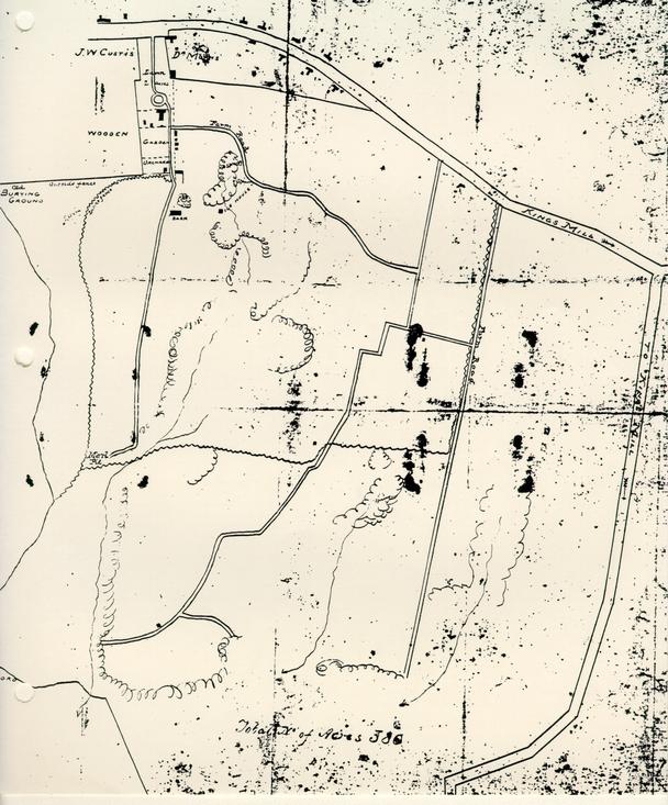
1. DEED.
By deed dated in May, 1857, the day being left blank in the deed, recorded November 14, 1859, in James City Deed Book #1 pages 367-8, Goodrich Durfey and Margret W. Durfey., his wife, conveyed to William Lyon land described as follows:
"All of that certain piece and trace of land situate and being in the County of James City known as part of the Bassett Farm, containing by recent survey 298 acres; and bounded as follows: North by lot of Charles Lively and the road from Williamsburg to York Town, East by a public road called Quarter Paths, South by the lands of William Allen, West by the lands of James W. Custis, __________ Munford and Goodrich Durfey to the beginning, at Charles Lively's lot."
2. DEED OF TRUST
By deed dated April 3, 1858, recorded November 14, 1859, in James City Deed Book #1 pages 369-70, William Lyon conveyed to J. B. Cosnahan as Trustee the same land acquired by him by the foregoing deed, in trust for the purpose of securing the payment of four bonds or single bills, under seal, …
This deed of trust refers to the foregoing conveyance from Goodrich Durfey to William Lyon, and speaks of the deed as being dated June 19, 1857. The deed is, at end dated June 19, 1857, though at its beginning its date is given as May ______ 1857. This error is of no importance.
3. LAND BOOK.
The earliest available Land Book in the local Clerk's Office for James City County is that for the year 1866, in which, on page 8 at line 12, William Lyon is charged in fee with 298 acres, it being stated that the tract has no name, and that it adjoins N. C. and J. H. Crenshaw, and is one-half mile southeast of the Courthouse. It will be observed that the deeds in Paragraphs 1 and 2 only refer to the land as being in James City County. Later conveyances affecting the whole of Bassett Hall, apparently containing 381 acres, refer to same as being located partly in the City and partly in the County. Apparently the portion conveyed to William Lyon was wholly in the County, as in the earliest available Land Book for the City of Williamsburg found in the local Clerk's Office, being for the year 1865, William Lyon is charged with no real estate. In the same Land Book, at page 3, line 14, Goodrich Durfey is charged in fee with "residence," in the City of Williamsburg; but there is no way of identifying it as being the Bassett Hall dwelling house.
4. WILL
By an un-numbered Will Book marked as follows: "Wills, James City Circuit Court," extending from November, 1869 to November, 1902, there is found on Pages 1 to 3, the will of Goodrich Durfey, and the order probating same…
4The material portions of the will are as follows:
"First, I give to my son, Zachary Durfey, either the Farm on which I now reside, that is to say, the land purchased by me of John Coke, formerly owned by Burwell Bassett, containing about 381 acres, with all the buildings thereon; and valued by me at $8,000.00, or my farm in James City County called 'Jockey's Neck,' containing about 500 acres, and valued by me at $5,000.00, the choice to be made by my said son, Zachary Durfey, when he shall arrive at the age of twenty-one.
Secondly. In case my son, the said Zachary Durfey, shall elect the farm first herein named I give and bequeath to him the sum of $2,000.00; or if the last named farm, the sum of $5,000.00 in addition to the real estate which he may so elect, and whatever else he may receive under any subsequent clause of this my will, thus making his portion herein before named $10,000.00 in either case.
***************************
Fifthly. I authorize and empower my Executors hereinafter named, or such as may execute this will, to rent out my two farms herein named to good tenants (who shall be required to keep them in good order) until my son, the said Zachary Durfey, shall arrive at the age of twenty-one, making choice of them as hereinbefore indicated; then they shall sell the farm not so elected, with any and all the real estate not hereinfore devised belonging to me, at such time and in such manner as they may think best for the interest of my estate, and to apply the proceeds in payment of my debts and legacies."
The sixth clause names the testator's son, Zachary Durfey, and his two daughters, Elizabeth Nimmo Durfey and Margaret G. Lea, wife of Col. John W. Lea, as residuary legatees and devisees.
"Seventh. I appoint my friend, James W. Custis, my son-in-law, Col. John W. Lea, and my son Zachary Durfey, whenever he shall arrive at lawful age, Executors of this my will."5
By the codicil dated December 6, 1868, it is provided that on account of the feeble health of James W. Custis, Thomas P. McCandlish is named as one of the Executors in his stead. The codicil further provides that the testator's son, Zachary Durfey, shall be allowed to qualify without security.
5. DEED
By deed dated December 15, 1869, recorded January 4, 1870, in Williamsburg Deed Book #1 pages 193-5, and in James City Deed Book #2 pages 273-5, Zachry G. Durfey, Executor of the last will and testament of Goodrich Durfey, deceased,...conveyed to Israel Smith land described in the said deed as follows:
"That certain tract or parcel of land situate partly in the City of Williamsburg and partly in the County of James City, State of Virginia, called "Bassetts Hall," containing about 381 acres, more or less, bounded as follows: Commencing on the north at the northeast corner of James W. Curtis' lot, thence along the street to the lot occupied by Dr. William S. Morris, thence south to the corner of said Morris' lot, thence east along ditch separating it from said Morris' lot and James Mahone, John Lucas and Charles Lively's lots to the road leading from, Williamsburg to York Town, thence along said road to the road called Quarter Paths, thence along last mentioned road to the middle of Tutter's Neck Dam, thence southwest to fence separating it from 'Delks', thence north to fence on the farm, thence southwest to corner of Munford's fence, thence northwest along said Munford's fence to the corner of Dr. Camm's land thence along ditch bank and fence separating it from said Camm's land, to the lot formerly owned by R. M. Bucktrout, deceased, thence east to the of said Bucktrouts lot, and thence north to the beginning, as will appear by reference to the plot of W. I. Morsett, marked B, and being part of the tract which the said Goodrich Durfey, in his life time, purchased of John Coke and Eliza, his wife as aforesaid, and the same first mentioned in the will of the said Goodrich Durfey, deceased."6
Zachary G. Durfey, as Executor and for himself individually, warranted title generally.
The deed recites that Goodrich Durfey and his wife in their life time conveyed to William Lyon 298 acres, briefly describing same, being a part of the tract of land which Goodrich Durfey purchased from John Coke and wife on November 18, 1845; that William Lyon to secure that payment of $7450.00 as purchase money, simultaneously conveyed said 298 acres to J. B. Cosnahan, Trustee, that Lyon was unable to pay same and agreed in writing with Durfey in 1865 to give the land back to Durfey, who agreed to give up the bonds still unpaid; that no deed was executed to carry out said agreement, that Lyon was still willing to abide by the agreement, that his bonds for purchase money had been given up and received by him, and that he and Sydney Smith, Substituted Trustee in place of J. P. Cosnahan, who had died, (the said Sydney Smith having been substituted as Trustee by order of the County Court entered December 13, 1869), consented and agreed to sign and execute this deed; that Durfey's last will and testament was admitted to probate, then quoting the first and second paragraphs as above given; that Zachary G. Durfey had arrived at the age of twenty-one and had qualified as the sole Executor, and had elected to take the farm Jockey's Neck, and had entered into a contract with Israel Smith to convey Bassett Hall to him.
The deed shows that the purchase price of $8,000.00 was to be payable as $4,000.00 in cash, and the balance in certain installments.
NOTE: It is reasonable to rely upon the correctness of the recitals made in the deed. Those that are material have already 7 been set out, as shown by the records. I consider the deed a good and effective conveyance of the Bassett Hall tract, I do not find of record the plat referred to in the description; though the present owners have in their possession two old plats of the tract which have already been exhibited to the present purchaser.
6. DEED OF TRUST
By deed dated December 15, 1869, recorded January 4, 1870 in Williamsburg Deed Book #1 page 196, and in James City Deed Book #2 page 275, Israel Smith conveyed to Sydney Smith and William S. Peachy the Bassett Hall tract, containing 381 acres as acquired by him by deed of even date for the purpose of securing to Z. G. Durfey, Executor of Goodrich Durfey, the sum $4,000.00 with interest, of which $1,000.00 matured on January 10, 1872, with interest annually from January 10, 1870; and $3,000.00 matured on January 10, 1874, with interest payable annually; as evidenced by single bills of Israel Smith under seal, dated December 15, 1869, for unpaid purchase money.
7. ASSIGNMENT AND RELEASE.
In James City County Deed Book #2 page 451 is found recorded a single bill under seal dated December 15, 1869, made by Israel Smith for $1,000.00 payable to said Durfey, as Executor; together with an assignment by the Executor to Richard W. Hansford dated June 19, 1871. The Clerk's certificate shows that on March 25, 1872, Richard W. Hansford, Assignee, appeared and acknowledged that the $1,000.00 bond had been paid in full.
8. ASSIGNMENT.
By Assignment dated September 10, 1873, recorded September 15, 1873, in Williamsburg Deed Book #1 page 346, Zachary G. Durfey, Executor of Goodrich Durfey, assigned to McRee Swift of New Brunswick, New Jersey, a single bill, under seal, of Israel Smith, dated December 15, 1869, and payable January 10, 1874, and the deed of trust set out in paragraph 6, securing same. The assignment recites that the single bill for $1,000.00 secured by said deed of trust had been paid by Israel Smith.
NOTE: It does not appear that the deed of trust set out in paragraph 6, has been formally released. The release set out in paragraph 7, is sufficient for all practical purposes as to the $1,000.00 bond. The $3,000.00 bond was assigned to McRee Swift as set out in paragraph 8, and while it has not been released I do not think that this would in any way place a cloud upon the title, as our statute prevents foreclosure of a deed of trust later than twenty years from the maturity of the obligation secured. In this instance, more than fifty years has passed since maturity of the bond.
It appears that the $3,000.00 bond is further secured as set out in deed of trust mentioned in paragraph 9 B.
9, A. DEED OF TRUST.
By deed dated February 5, 1872, recorded on the same day in Williamsburg Deed Book #1 pages 285-6, Israel Smith and Rebecca M. Smith, his wife, conveyed to William S. Peachy, Trustee, the Bassett Hall tract, containing about 381 acres, for the purpose of securing to William W. Vest the sum of $1500.00 and interest as evidenced by bond of Israel Smith dated February 5, 1872, payable on or before February 5, 1873.
9NOTE: The lien of this deed of trust does not appear to have been released of record; but as the statutory provision of twenty years for the enforcement of a deed of trust has long since elapsed I do not regard the failure of the records to show release of same as constituting a cloud upon the title.
9,B DEED OF TRUST.
By deed dated September 10, 1873, recorded September 15, 1873, in Williamsburg Deed Book #1 pages 347-8, Israel Smith conveyed to William S. Peachy, Trustee, the Bassett Hall tract containing 381 acres to secure to McRee Swift the performance of Smith's agreement as set out in the deed of trust. Recital is made that McRee Swift bought the $3,000.00 bond secured by the deed of trust set out in paragraph 6. at Smith's request; that the rate of interest is changed from 6% to 8% payable in New Jersey, and that the bond will mature on January 10, 1874.
NOTE: The lien of this deed of trust has not been released, but same is no longer enforceable under the Virginia law as above mentioned.
10. WILL.
The will of Israel Smith was probated on April 14, 1879, which order of probate and the will and codicil are recorded in Williamsburg Will Book #1 pages 311-313. The order shows that the will, dated December 6, 1870, and the codicil dated December 25, 1875, were probated and that Rebecca M. Smith qualified as Executrix with leave given Fannie Belle Smith and Alice Colden Smith to come in and qualify. The will appointed Rear Admiral Charles H. Bell and Rebecca Minturn Smith, the Testator's wife, Executors. The codicil recites 10 the death of Rear Admiral Bell and appointed the said Rebecca M. Smith and the Testator's daughters, Fannie Belle Smith and Alice Colden Smith, as Executors.
The second paragraph of the will is as follows:
"Second. I give to my Executors full power and authority to sell and convey all, or any, of my real estate."
The third paragraph provided that money derived from sales of real estate should be invested by the Executors and the interest paid to his wife during her life and at her death that the proceeds be equally divided among his children upon reaching twenty-one years of age.
The fifth paragraph of the will is as follows:
"Fifth. If my Executors deem it best not to sell my real estate I direct that the profits, rents or income derived from said estate be paid to my, wife during her life time, and at her death to be equally divided among my children, if they have arrived at the age of twenty-one years, and if any have not arrived at this age I direct that the share of any such children, be invested at interest to the benefit of such children, or any of them, during their minority but to be paid as far as necessary for their support."
NOTE: The widow Rebecca M. Smith, lived until the year 1911. I am informed that the testator, Israel Smith, was the father of four children by his two marriages, all of whom survived both him and his widow, all of whom reached the age of twenty-one years before the death of the widow. I am of the opinion that these four children, namely: Alice Colden Smith, Fannie Belle Smith, Edith Minturn Smith and Margaret W. S. Bird, nee Smith, sometimes called "Meta S. Bird," became the fee simple owners of the property at the expiration of the life estate of Rebecca M. Smith.
11. DEED
By deed dated October 12, 1882, recorded January 23, 1883 in James City Deed Book # 4 pages 324-5, Rebecca M. Smith conveyed to William H. E. Morecock a parcel of land in 11 James City County containing according to survey, one acre and 1/20 of an acre, being a portion of the Bassett Hall farm. The deed refers to a plat attached thereto, made by Carey P. Armistead, which plat is recorded on page 325.
12. RIGHT OF WAY.
By right of way agreement dated November 24, 1900, recorded December 31, 1900 in James City County Deed Book #7 page 461 Rebecca M. Smith, Alice Colden Smith, Edith M. Smith, Meta W. S. Bird and H. S. Bird, her husband, and Fannie B. Smith granted to the Chesapeake Telephone & Telegraph Company, A Virginia Corporation, a right of way for a telephone and telegraph line, appliances, etc. over and along that tract of land in Jamestown District, James City County, Virginia, near the City of Williamsburg, fronting on the main road leading from Williamsburg to Yorktown, for the purpose of running on that portion of the said tract of land then occupied, or which might thereafter be occupied, as a public road or roads. The agreement was not to be exclusive.
13. DEED.
By deed dated November 7, 1903, recorded December 9, 1903 in James City Deed Book #9 pages 148-9. Rebecca M. Smith, Executrix under the last will and testament and widow of Israel Smith, deceased, Alice Colden Smith, Edith Minturn Smith, Meta W. S. Bird and H. S. Bird, her husband, and Fannie B. Smith conveyed with General Warranty and the usual covenants to Elling P. Strand land described as follows: 12
"That certain tract, piece or parcel of land situate, lying or being in Jamestown Magisterial District, James City County, Virginia, containing by actual survey 112-¾ acres, bounded and described as follows: Beginning at a large cedar tree on the main road leading from Williamsburg to Yorktown and running thence along said road S. 51.25° E. 1.31 chains, thence S. 68° E. 9.40 chains, thence S. 58° E. 6.63 chains to what is known as Quarter Paths road leading to King's Mill; thence along said Quarter Paths road S. 10° W. 32 chains to gate post thence S. 19° W. 9.94 chains along said road., thence S. 49° W. 5.80 chains along said road: thence S. 73.5° W. 7.92 chains along said road, thence S. 72.5° W. 17.44 chains, thence N. 20.75° E. 63.62 chains to point of beginning, the same being a portion of the tract of land called Bassetts Hall conveyed to Israel Smith by deed from Z. G. Durfey, Executor of G. Durfey, deceased, William Lyons and Sydney Smith, Substituted Trustee, bearing date on the 15th day of September, 1869, and recorded in the Office of the Clerk of the Court for the County of James City and the City of Williamsburg in James City Deed Book #2 pages 273-4, to which deed reference is here made."
14. DEED
By deed dated November 12, 1903, recorded January 16, 1904, in James City Deed Book #9 pages 195-6, Rebecca M. Smith, as widow and Executor of Israel Smith, deceased, Alice Colden Smith, Fannie B. Smith, Meta W. S. Bird and H. S. Bird, her husband, conveyed with General Warranty and the usual covenants to Milan Smith 40 acres of the Bassett Hall tract, described as follows:
"That certain tract, piece or parcel of land situate, lying and being in Jamestown Magisterial District, James City County, Virginia, and known as a part of Bassetts Hall, tract supposed to contain 40 acres, be the same more or less, and bounded as follows, to-wit: Commencing at a point on the Quarter Paths road leading to King's Mill where the land hereby conveyed intersects with the land recently conveyed to Elling P. Strand, a course running N. 72.5° E., thence running down said Quarter Paths road to Tutter's Neck Creek, thence along the meanderings of said Creek or swamp to the western boundary of the said Bassetts Hall tract, thence along the western boundary of the said Bassetts Hall tract separating it from Delks to a point where the southwestern corner of said Elling 13 P. Strand's land intersects and thence in a straight line N. 72.5° E. to the point of beginning; bounded on the north by the land of Elling P. Strand, on the east by the said Quarter Paths road, on the south by the said Tutter's Neck Creek, or swamp, and on the west by Delks; the same being a portion of the tract of land conveyed to Israel Smith by deed from Z. G. Durfey, Executor, William Lyons and Sydney Smith, Substituted Trustee, bearing date on the 15th day of September, 1869, and recorded in the Clerk's Office of James City County and the City of Williamsburg in James City Deed Book #2 pages 273-4.
15. DEED
By deed dated January 4, 1913, recorded January 9, 1913, in Williamsburg Deed Book #6 pages 312-13, and recorded January 16, 1913 in James City Deed Book #13 pages 567-8, Meta S. Bird and Hugh S. Bird, her husband, conveyed with General Warranty and the usual covenants of title to Edith Minturn Smith by the following descriptions:
"All the right, title and interest of the said parties of the first part in and to that certain piece, parcel or tract of land situate, lying and being partly in the City of Williamsburg, Virginia, partly in Jamestown District, James City County, Virginia, generally known as Bassett Hall, and containing two hundred and twelve (112)[sic] acres, more or less, but sold in gross and not by the acre, more particularly bounded and described as follows: On the north by Francis Street, the property of the Morecocks and other property and by the main road leading from Williamsburg to Yorktown, on the east by the lands of L. W. Wales, H. W. Dana and other properties and a lot now owned by the said Edith Minturn Smith; together with the buildings and improvements thereon, the interest of the said Meta S. Bird in the said property hereby conveyed being a one-fourth undivided interest; the same being a part of the land of which Israel Smith died seized and possessed, the same having been conveyed to him by Z. G. Durfey, Executor on the estate of Goodrich Durfey, and William Lyons and Sydney Smith, Substituted Trustees, by deed dated December 15, 1869, and recorded in the Clerk's Office of the City of Williamsburg and County of James City in James City Deed Book #2 pages 273-4. to which reference is here made."
16. OPTION AGREEMENT
By agreement dated March 15, 1916, recorded March 17, 1916 in James City Deed Book #15 pages 416-17, Fannie Belle Smith, Alice Colden Smith, and Edith M. Smith contracted and agreed with James R. Branch that they would within ninety days from the date thereof sell and convey to said James R. Branch certain land at $300.00 per acre, according to survey to be furnished by the grantors, the $500.00 cash payment for the option to apply on the purchase price. The land to which the agreement applied is described as follows:
"All that certain piece or parcel of land together with its appurtenances, being the eastern portion of the property remaining and known as the Bassett Hall tract, beginning at the point on the south side of York or Woodpecker Street where said tract joins the land of Irving S. Whitcomb, and extending along south side of said York or Woodpecker Street in a westerly direction three hundred sixty-five feet, more or less, to a point forty feet east of the western point of said tract at its juncture with said street, extending back southwardly and between parallel lines, the eastern line being the present western line of said Whitcomb property to the southern boundary of said tract, and containing between 30 and 40 acres."
The land owners further agreed to dedicate a street forty feet wide running south from York Street the entire length of Bassett Hall tract and parallel and adjoining the western line of the property contracted to be sold, which street should be for, the joint use in common of the two properties.
17. DEED
By deed dated April 10, 1916, recorded May 1, 1916, in James City Deed Book #16 pages 125-6, Fannie Bell Smith, Edith [sic] Colden Smith and Edith M. Smith conveyed to Williamsburg Park Corporation, a Virginia 15 and the usual covenants of title, land described as follows:
"All that certain piece or parcel of land lying and being in James City County near Williamsburg in the State of Virginia, containing thirty-six and one half (36 ½) acres, according to a survey or plat dated the 8th day of April, 1916, made by Bolton, Clark and Pratt, Inc., Civil Engineers of Richmond, Virginia, which plat is attached to this deed to be recorded herewith for the purpose of describing the boundaries of the land hereby conveyed. The lands hereby conveyed being a portion of the residue of the Bassett Hall tract and the said lands are bounded on the north by York Street, on the east by lands of the York Land Company and on the west by the forty foot road which is hereby set apart and granted as a easement of way by the parties of the first part to the parties of the second part, its successors and assigns, for the joint use of the owners of the residue of the said Bassett Hall tract, and the owners of lots and parcels of land hereby conveyed. The said road forty feet in width is to be at all times open its full width and length as shown on said plat."
On page 126 of P. B. 16, is recorded the plat referred to showing that the land conveyed is thirty-six and one half acres exclusive of the road reserved, and further showing the road between the unsold Bassett Hall land and the parcel conveyed.
NOTE: It will be observed that the land conveyed by deed set out in paragraph 17, is without doubt the same land covered by the option agreement set out in paragraph 16, though James R. Branch did not untie in said deed. It is indicated, however, by a deed of trust from Williamsburg Park Corporation to E. Lorraine Ruffin, Trustee, dated April 17, 1916, recorded in James City Deed Book #16 pages 127-31, from the quoted resolution of the Board of Directors of the grantor Corporation that said Corporation took over as its obligation an agreement of Garrett & Co. with James R. Branch as to the purchase of said land.
18. SEWER RIGHT OF WAY
By right of way agreement dated June 3, 1921, recorded August 18, 1921 in Williamsburg Deed Book #9 pages 216-17, Edith M. Smith and Alice Colden Smith conveyed to the City of Williamsburg a right of way over, under and through property 16 therein described for the purpose of constructing, operating maintaining and repairing a sewer main…
19. CURRENT LAND BOOKS.
In the Land Book of the City of Williamsburg for the year 1927, page 14, line 30, Israel Smith and E. M. Smith Estate is charged in fee with "House and lot, Bassett Hall, East Francis Street," with land and buildings. In the Land Book for James City County for the year 1927, page 8, line 19, Israel and E. M. Smith Estate is charged in fee with a part of Bassetts Hall containing 132½ acres.
NOTE…
20.
…
CERTIFIED,
C. W. Hall, Attorney at Law
Illustration #5
From Tucker-Coleman Collection, Research Department
Letter of A. P. Upshur to B. Tucker Esq., WilliamsburgVaucluse Jany 27 1840
Dear Judge
I received last night, your letter of the 13th & at the same time, one from Christian upon the same subject, dated 12th … I have given the night to reflection on the subject of Galt's1 land, & have come to the conclusion to take it at $10000. I expected to get it for less, but as it seems to be considered worth that, I will agree to give it. I confess however, that it is not without some misgivings, that I burthen myself with such a debt, at my time of life … At all events, if I buy Galts & should not sell this, I can sell that if it should become necessary. As I shall have to set it up with the necessary labour, I shall have occasion for all the cash I can raise. Cole will bear this in mind, & obtain as long credits as he can. As he & Christian were both present when Christian undertook to make the purchase for me, they will of course, move together in the matter. John Coke is waiting my determination, & therefore I should be glad if you would communicate it to him. I speak of 10 000 $ as the price, because both you & Christian seem to think that it can certainly be bought for that … But I do not mind a few hundred either way …
Letter of A. P. Upshur to B. Tucker Esq WilliamsburgVaucluse AP 5 1840
My dear Judge
…
As to my Galt business you will perceive from a letter of mine written since that, to which yours is a reply, that the course you have pursued, is exactly according to my wishes. I hope I shall succeed in reconciling my family to the change. It is probable that they will not go with me in May …
Letter A. P. Upshur to B. T. Tucker Esq. WilliamsburgRichmond Nov 28 1840
Dear Judge
…
On my arrival at Jas: Town, I met Goodrich Durfey, who proposed to purchase my land. I had offered it to Tyler, (who requested me to give him the refusal) at 12 000 $ payable by annual instalments, & told Durfey that I could not give him a positive answer til Tyler should decide; but that I would not wait many Days for that. I wrote to Durfey from Petersburg, offering the land to him for $12 000, he to relieve me from Vest & Coke's mortgages, & to pay me the balance with interest at any time he chose, within reason; & telling that I should be ready to close bargain with him, by the time I could receive his answer, whether I should have heard from Tyler or not. I have not heard from either of them … I am determined to sell, although I would greatly prefer to retain the land … I am unwilling to burthen myself with such an amount of debt [this debt and other] I am otherwise determined to sell, provided I can get cost. The actual cost to me was about $10500, & if I can do no better, I am willing to take what will be equivalent to that sum with interest from the 5th of May, 1840, to the time of sale …
From Tucker-Coleman Collection-Dept. Research
A. P. Upshur
To-B. Tucker Esq. WilliamsburgVaucluse June 17 1836
Mr Dr Sir
I have just received yours of the 3d Inst I had heard before, of the purchases & sale of Col Bassetts land, & did not doubt that there was good reason for your not retaining it for me. You judged rightly, that I could not conveniently pay the whole sum at once, particularly as I am to run a race through the C of Appeals for the large debt I have recently recovered in Staunton. I am very sorry indeed, that it has so turned out…
Abel P. Upshur
To- Beverley TuckerVaucluse March 17t 1837
My dear Sir
…
Your suggestion about my removal to Williamsburg, is not a new idea to me. I have meditated …and one of my chief inducements was, that I should have the counsel & assistance of yourself …
A. P. Upshur
To B. Tucker Esq. WmsburgVaucluse July 28 1838
My dear Sir
I should delay yet a little longer, my reply to your letter, if it was not for that part of it, which relates to Doctor Peachy's land. As he has an offer for it, & is reserving it for me, I ought not to leave him any hopes in uncertainty as to my wishes. Please say to him that I do not wish to purchase.
A. P. Upshur
To- B. TuckerVaucluse Novr 15th 1838
My dear Judge,
…
Is there any better mode of making a few thousands easily than by planting the morus multicantis? There seems to be a growing disposition in the country to engage in the making of silk, and the probability is that the demand for the mulberry will not decrease for many years. If you agree with me, I propose to you to take one half my purchase of the vineyard and engage in the culture of that tree. We shall require but a few acres of the land, and it is probable that the balance of the estate will rent out for enough to cover all our expences except the cost of the plants. Think of this and let me know the result.
A. P. Upshur
To-B. Tucker Esqr WilliamsburgVaucluse January 14th 1839
Dear Judge
…
I have received a letter from Col Mc.candlish, written in behalf of William U Delk, expressing his desire to lease, or rent the Vineyard, for farming purposes only. By the same mail, I also received a letter from Captain Charles Lively, expressing the desire of himself, and his co-tenant Jarvis, to remain on the land, upon the same terms as heretofore. I have written to these men, referring them to you. Will you do me the favour to make with all, or either of them, such bargain as you think proper.
…
A. P. Upshur
[To-] B. Tucker Esqr WilliamsburgVaucluse Feby 25 1839
…
I am glad to set off with Christian. The land I know, is intrinsically worth twice what I gave for it, if the title were clear; but it is not clear. The present condition of the land is such, that I could not make any thing from it, without expending 1500$ in buildings & as much more in labour, (exclusive of slaves,) utensils & stocke. If I should lose the land, I should probably lose the improvements, and should certainly lose a great deal in utensils and stock . … I think I do well to be off. The interest is enclosed, which please deliver to Christian…
A. P. Upshur
To Judge B. Tucker WilliamsburgNorfolk Decr 4 1840
Dear Judge
…
I have this moment, received a letter from Durfey, decling my offer. He says my terms are so much more than he is willing to accept, that he deems it unnecessary to make my any offer, but he also says that he is anxious to have the land & will give as much as any one else will give.…
… Remember that the property cost me $10500 on the 5 May last, & I shall be very glad to get my money back with interest, or without a serious loss.
Vaucluse Ap 10 184l
A. P. Upshur[To] B. Tucker Esq Williamsburg
My dear Judge
…
Your letter has given the coup de grace to my already expiring hopes, in regard to the sale of my land. Well, I have only to look out for the ways & means of couplet my payments for it …
A P. Upshur
[To] B. Tucker Esq WilliamsburgNorfolk June 10 1841
Dear Judge
…I have prepared an advertisement to be inserted in the Beacon of this place & the Whig of Richmond notifying all the world that my Wms burg land is for sale … If I can get within five or six hundred dollars of the actual cost , I shall be content …
A. P. Upshur
[To] B. Tucker Esq. WilliamsburgVaucluse July 28 1841
Dr Judge
…
I would greatly prefer to sell, & am still in hopes that a purchaser will offer. This however, is so improbable, that I will not lose a good tenant by waiting for it. I am wholly unable to say what sum it will or ought to rent for. Mccandlish told me that he did not think it would command more than 300$, but surely that must be a mistake. However, get what you can…
A. P. Upshur
[To] B. Tucker Esq WilliamsburgVaucluse Aug 7t 1841
Dear Judge
… Entre nous, I have for some time feared that I should be compelled to encounter such a sacrifice with this Wms bg land. I cannot pay the mortgages, if called on to do it shortly, so that, it depends very much upon Cole & Coke, whether I am to be ruined or not…I will hold on a little longer…
Appendix #6
List of pictures on file of Bassett Hall
- 1. Bassett Hall, north elevation, photograph #N1532
- 2. Bassett Hall, Francis Street, #1491 — photostated from original in the library of the New York Historical Society
- 3. Bassett Hall, Francis Street, photostated from — photograph in Harper's New Monthly Magazine, p. 944 [Article bound in vol. in Wm. & Mary Archives entitled "The College of William & Mary," Vol. II.]