Nicholas-Tyler House Archaeological Report, Block 4-1 Building 4A Lot 192-196 and 200-204Originally entitled: "The Nicholas Site: Block 4 Area A, A Report on Archaeological Work Undertaken in 1968"
Colonial Williamsburg Foundation Library Research Report Series - 1076
Colonial Williamsburg Foundation Library
Williamsburg, Virginia
1990
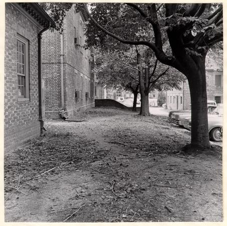 Frontispiece.
View of a portion of the Nicholas property prior to the 1968 excavations. The present courthouse structure is at left and the area of subsequent excavation is the foreground. Photo from the north. 68-INH-2926
THE NICHOLAS SITE:
Block 4 Area A A
Report on Archaeological Work Undertaken in 1968
TABLE OF CONTENTS
| Page | |
| Introduction | 1 |
| Aperçu of the Site's History | 2 |
| The Archaeological Evidence | 4 |
| The Artifacts | 14 |
| Conclusions | 14 |
| Footnotes | 16 |
| Appendix I, Summary of Excavation Register Numbers | 17 |
| Appendix II, Description of Artifacts Illustrated in Plate IV | 20 |
| Plate I, Area west of the courthouse prior to the 1968 archaeological study | Frontispiece |
| Plate II, East/west robber trench discovered in 1968 | 8 |
| Plate III, Brick-lined sump with its attached drain | 12 |
| Plate IV, Artifacts found on the Nicholas property during the 1968 archaeological study | Opposite page 20 |
| Figure 1, Detail of Frenchman's Map | 3 |
| Figure 2, Drawing of features discovered in the vicinity of the Nicholas House during the 1931 and 1968 excavations | 5 |
Introduction
In 1931, prior to the construction of the Williamsburg and James City County Courthouse, an archaeological investigation was launched on portions of Colonial Lots 194, 195, 196, 202, 203, and 204; property owned by Robert Carter Nicholas in 1770. During that study, foundations of what was thought to be the east end of the Nicholas dwelling were uncovered.1 Since building materials had been stacked on part of the site, it was thought possible that the building extended westward beyond the foundations uncovered in 1931. Consequently, the Department of Architecture requested the hitherto unexcavated area be explored so that reconstruction planning on the main house could be finalized.
The fact that the westerly remains, if any, of the structure were all but erased by modern disturbances, coupled with a lack of information concerning the 1931 discoveries, combined to make the interpretation of the scant 1968 evidence an arduous task. Indeed, it would seem likely that conclusions arrived at here may be subject to modification or even rejection when a re-examination of the features unearthed in 1931 can be undertaken. At any rate, the following is primarily a report on the archaeological evidence found in 1968 (September 11 -17), but pertinent structural features, located during previous studies, are mentioned.
Aperçu of the Site's History
The property in question comprises an entire block having Ireland Street as a southern limit, England Street on the east, King Street on the west, and Francis Street on the north. (See Figure 1) By 1724, the courthouse and jail for James City County had been situated on the land2 but, in 1770, the property was sold at public auction and Robert Carter Nicholas apparently was the buyer.3 Although he held the title on the land for only seven years, Nicholas is believed to have been responsible for the construction of a dwelling destined-to survive for a century. The building was erected between 1770, when he bought the property, and 1777, when he advertised it for sale. The latter notice described the house as being "large and commodious, having four rooms on a floor, and is in pretty good repair."4 It was conjectured that the dwelling was constructed soon after the land was acquired, since, if the house had been built within three or four years prior to the 1777 advertisement, the condition of the structure should have been better than "in pretty good repair."5
The ownership of the land, along with the main house and dependencies, passed through, no fewer than, eleven families from 1778 to 1873. Obviously, during that 95 year period, the dwelling was refurbished many times.
3
 Figure 1
Detail from the Frenchman's Map with arrow pointing to Robert Carter Nicholas property.
4
Indeed, some of the repair work was mentioned in the extant documentation, but, it would appear that no major changes to the architectural plan were effected until 1838. In that year, according to an existing insurance policy, an addition, measuring 16'0" x 16'0", had been attached to the west side of the house. The extension was to be used as a kitchen and it was to replace an outbuilding destined to be "taken down and removed."6
The surviving records indicate that at least two fires damaged the dwelling during its century-long existence. The first occurred in 1779 but only burned a portion of the roof. However, the second, in 1873, apparently devastated the entire house and, thereby, ended the life of the building.
The Archaeological Evidence
As mentioned in the introduction, the 1931 archaeological study revealed the remains of, what was considered to be, the eastern half of the Nicholas dwelling. (See Figure 2) These comprised portions of the building's east and south including the alleged southeast corner, the southeast sector of a porch to the rear of the house, and various other interior foundations. A basement had been installed
5
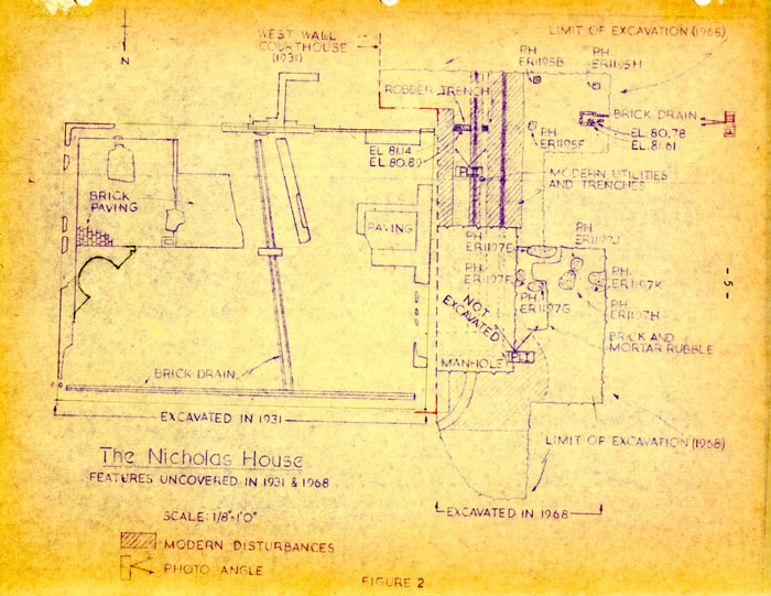 The Nicholas House
Features Uncovered in 1931 & 1968
6
beneath this eastern segment of the structure, and its brick flooring, surviving only in two areas of the cellar, was reached some 3'0" below the 1931 grade level. Armed with the knowledge provided by previous digging, the 1968 project set out to find the building's western and northern extremities, along with any exterior chimneys and/or porches, and to continue excavating the cellar in hopes that a bulkhead entrance might be discovered.
Usually, when colonial structures survived into the nineteenth century, extant insurance records can be examined to determine the size, fabrication, and general location of main buildings and the more prominent dependencies. However, after a study of the Nicholas property plats, the size of the main house remained as much in doubt as before. In 1801, the dwelling was described as being "538 feet long by 32 feet";7 thereafter the dimensions fluctuated as follows:
| 1806 | -- 58' x 28' |
| 1819 | -- 56' x 28' |
| 1820 | -- 30' x 60' |
| 1823 | -- no measurement recorded |
| 1830 | -- " " |
| 1838 | -- 60' x 32' |
| 1846 | -- no measurement recorded 8 |
In order to determine the location of the dwelling's western extremity, the grid was laid out so that any length from 50'0" to 60'0" would fall within a 10' square. Likewise, to find the structure's north wall, an area which would uncover the front of the building between widths of 25'0" and 40'0" was planned for investigation.
Since the placement of the main building's south wall had been established in 1931, it was decided to locate that feature and then pursue it to the dwelling's southwest corner. Therefore, a hole, 5'6" x 13'0", was sunk immediately west of the courthouse and east of a 3'6" wide trench that contained a north/south sewer line. Upon removing the 3" thick layer of topsoil, it was evident that the area had been much disturbed by modern features. The builder's trench for the courthouse extended out some 1'6" and a utility cutting, averaging 1'2" in width, ran on a north/south course down the center of the area, and both stirred the strata to a point below the top of the natural subsoil. Even so, a short section of an east/west robber trench miraculously survived amid the modern disturbances. (See Figure 2)
The robber trench fill included fragments of brick, plaster, and mortar, and was found only 1'5 ½" below modern grade. (See Plate II) As the trench only extended down
8
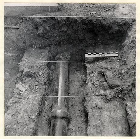 Plate II
Close-up of the east/west robber trench which survived amid three different modern disturbances: the builder's trench for the 1931 courthouse at left, the water drainage pipe in the center, and a 3' 6" wide sewer utility that is partially visible at the right. Photo from the north. 68-INH-2925
9
another 3", it was determined that if it was related to the 1770 house, the western part of that building had never possessed a cellar. The wall remains proceeded westward but were cut through by the 3'6" wide sewer trench, and digging beyond that modern feature failed to produce any trace of the robber trench. Hence, it must be conjectured that if the trench was, indeed, part of the 1770 house, that building's southwest corner had been located within the area disturbed by the insertion of the sewer line. Consequently, if this theory is correct, the Nicholas House had an east/west measurement of from 46'0" to 49'6"; both of which are shorter than the extant documentation would have us believe.
This south wall robber trench had cut through a thin stratum of brick and mortar rubble (E.R. 1196C); a layer which initially was thought to represent the debris from the construction of the main building. However, the artifacts recovered from the deposit included two fragments of creamware which would appear to date after c.1780, in which case, the wall evidence, located in 1968, would postdate the construction period (c. 1770-1777) for the Nicholas dwelling. It could be argued that the sherds of creamware had dropped between the floor boards, but it would seem just as likely that the robber trench represented a later addition to the structure; perhaps the kitchen 10 extension known to have been completed by 1838. The problem of interpreting the 1968 evidence is amplified by the fact that the 1931 archaeological map depicts all of the brickwork and features as being contemporaneous, which they clearly could not have been.
The bulk of the destruction rubble, deposited during the dismantling of a building, is usually found close to the perimeter of the walls being demolished. Thus, the fact that destruction debris containing post c.1825 artifacts (E.R. 1197D), was found spreading westward for only a distance of 4'9" beyond the sewer trench, would seem to indicate that the robber trench found in 1968 probably returned within the area subsequently occupied by that modern utility disturbance. In addition, the rubble had been used to fill and seal five holes (E.R. 1197E-J) immediately west of the sewer line and these features would have undoubtedly been outside the area of a structure. (See Figure 2) Even so, these facts still cannot shed any light on the question as to whether the remains were part of the 1770 house or the 1838 addition.
Evidence of the Nicholas House's north wall could not be found; however, with the aid of a 1931 discovery and negative evidence from the 1968 work, the placement of the building's front foundation can be estimated to within a few feet of its original position. The remains of the 11 structure's east wall stretched a distance of 29'0", providing a minimum possible width for the building. During the 1968 excavations, it was discovered that the area, where the northwest corner and the north wall might have been found, had been disturbed by the insertion of a manhole and an east/west return for the sewer. However, if the width of the structure had been more than 32'0", some evidence of the front of the building would have been discovered, since from that point northward the strata had riot been disturbed. Therefore, if this negative discovery can be accepted, the width of the Nicholas House would have been from 29'0" to no more than 32'0"; a measurement that would agree with two of the extant insurance plats.
Located some 15'3" west of the courthouse was found a brick-lined sump with a portion of a drain extending westward from it. (See Plate III) The pit had interior measurements of 1'1" x 1'0" while the westerly trough was 6" in width. The natural subsoil served as the bottom for both features. Traces of mortar were present on the bricks, but, as clay was used to hold them in place, it was deduced that they had been reused. Brick sizes ranged from 8 ¾" x 4" x 2" to 8 ½" x 4 ¼" x 2 7/8". Three courses had survived on the sump's north and east
12
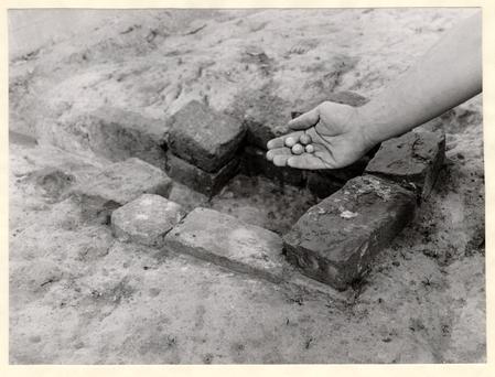 Plate III
Close-up of the brick-lined sump with its attached westerly drain. The reused bricks were held in place by clay and the sump's walls had been at least three courses high. The four marbles were recovered from the drain's primary fill, 68-INH-3004
13
walls, while only two remained on the other sides. The drain's trough was formed by laying bricks lengthwise and on edge.
The sump had been filled with brown clay containing flecks of brick and shell (E.R. 1195C), along with artifacts that indicated a deposition of post c.1770 to 1780. The finds included a fragment of creamware, six small pieces of wine bottle glass, stem fragments from at least five clay tobacco pipes, and, at the bottom, four clay marbles. The last brought to mind the legend about Vice-President Tyler's having been playing marbles on this property when notified that he was to assume the presidency.9 Although it would be amusing to be able to claim that Tyler lost his marbles in Williamsburg, the chances that those found in the drain belonged to him are extremely unlikely.
The sump could have been utilized in a number of ways, but two of the more reasonable conjectures are that it served as part of a water shed system from a roof, or as a drain for kitchen waste. Neither theory could be substantiated, but possible support for the latter was forthcoming. Three small square postholes (see Figure 2) of what was thought to be a fence around the sump area, were discovered. Two of them (E.R. 1195B and F) contained no datable artifacts, but the third (E.R. 1195H) produced, 14 among other items, a fragment of whiteware which could not date earlier than c.1810. The three holes were so small that most of their space would have been filled by the post; consequently, the artifacts found in the features more than likely represented the abandonment of the barrier. Since the fence was torn down around the same time that the sump was filled in, it was deduced that the two could have. been associated.
The Artifacts
Unfortunately, the artifactual remains on the Nicholas site were as sparse as the structural evidence. The reason for the absence of any quantity of eighteenth century material was not determined. However, the entire area studied in 1968 had been graded and, no doubt, this removed some artifact-bearing strata. The significant items are illustrated in Plate IV and are described on page 20.
Conclusions
It was unfortunate that any western extremity of the Nicholas House could not be found during the 1968 excavations. Consequently, the absence of that evidence gives rise to the question of whether the dwelling extended east of the foundations uncovered in 1931 instead of west of them. 15 Obviously, prior to further reconstruction planning, a re-examination of the features located in 1931 should be made, along with a further study of the area east of those remains. As it would be extremely difficult to make a sufficiently careful analysis of the surviving remains in the cramped and poorly lit basement conditions currently prevailing beneath the building, it is proposed that the work be delayed until that part of the Courthouse immediately above can be gutted.
It is entirely possible that as the site has suffered so many disturbances no additional data will be forthcoming. Nevertheless the relatively small amount of labor involved to make such a determination weighs heavily in favor of doing it.
Footnotes
APPENDIX I
| Excavation Register -(E.R.) Number | |
|---|---|
| 1195B | Square post hole, located in the southeast corner of the area, filled with mixed clay and brick flecks and sealed by the layer of light brown clay (1195A); no datable artifacts. |
| 1195C | Brown clay with brick and shell flecks filling and representing the abandonment of the brick lined sump, post c.1780-1810. |
| 1195E | Square post hole, located in the northwest portion of the area, filled with mixed clay and brick flecks and sealed by the layer of light brown clay (1195A); no datable artifacts. |
| 1195H | Square post hole, located in the southwest section of the area, filled with mixed yellow clay and sealed by the layer of light brownclay (1195A); post c.1810. |
| 18 | |
| 1196C | Thin stratum of brick and mortar rubble mixed with brown clay sealed by the layer of black loam and ashes (1196B) and over laying the natural subsoil. The robber trench for the main building's south wall cut through this deposit; post c.1780. |
| 1197D | Destruction rubble, extending only 4'9" west of the sewer trench, containing brick, mortar, and plaster debris and overlaying the natural subsoil; post c.1825. 1197E Large post hole, located against the south edge of the area, filled with mixed clay and brick rubble and sealed by the layer of destruction debris (1197D); last half of the 18th century. |
| 1197F | Post hole, located northeast of the hole 1197E, filled with brick rubble and sealed by the destruction debris (1197D); no finds. |
| 11976 | Post hole, located north of the hole 1197E, filled with mixed yellow clay and brick rubble and sealed by the destruction debris 1197D; no finds. |
| 19 | |
| 1197J | Square post hole, abutting the above feature to the south, filled with mixed brown clay and brick rubble and sealed by the destruction debris (1197D); no finds. |
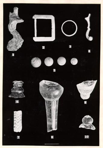 Plate IV
Artifacts found on the Nicholas property during the 1969 archaeological study. Descriptions begin on opposite page. 68-INH-3005.
APPENDIX II
Description of Artifacts Illustrated in Plate IV
- 1.Iron gun cock in poor state of preservation, probably from a fusil or sporting piece, the jaws had been tightened with a screw measuring l 5/8" in length and ¼" in diameter, the total surviving length from the top of the jaw screw to the base of the cock is 3 1/8". Retrieved from a late nineteenth century deposit, but the item is surely of eighteenth century date. [4039-E.R.1194A-4A]
- 2.Cast brass harness buckle, plain face save for vertical grooves cut near the shoulder, all four corners beveled, frame measures 1 7/8" x 1 5/8" and was used with a 1 ¼" wide leather strap, tang missing. Unstratified but of a typical eighteenth century design. [4040-E.R.1195-4A]
- 3.Cast brass curtain ring, the outer diameter 1 3/16" and the width of the metal 3/32". Found among undatable material but undoubtedly of eighteenth century date. [4041-E.R.1197B-4A]
- 4.Decorative cast brass object of uncertain purpose, perhaps a foot or handle, drilled for attachment by a rivet or bolt at its broken end; surviving length 1 15/16". Unstratified but almost certainly of eighteenth century date.[4042-E.R.1196-4A]
- 21
- 5.Four clay marbles of descending size, diameters ranging from ¾" to ½". Date of deposition - post c.1770-80. (4043 through 4046-E.R.1195C-4A]
- 6.Drinking glass stem of unusual character, a rare pale olive green and bubbled lead metal. The stem comprises a rudimentary mushroom knop above a slightly rising foot, and is topped by a smaller inverted knop of similar character. Above that is a merese or collar surrounding what may have been either a hollow stem or a tapering-bottomed conical bowl. No close parallels have been found for this glass and the possibility exists thaw it may be a product of an unidentified American factory. The surviving features would suggest a date in the early 18th century, but the strange color, crude workmanship, and combination of features make such dating unreliable. [4047-E.R.1195-4A]
- 7.Straight stem fragment from an opaque-twist decorated glass, the ornament comprising a sixteen-ply spiral gauze around a pair of cork-screwed tapes. About 1755-70. (4048-E.R.1195A-4A]
- 8.Stem and base of bowl from a heavy, two-piece wine glass, the bowl almost certainly waisted. A long cigar-shaped or torpedo tear extends from the bowl base to the full surviving length of the stem. The weight of this glass 22 would suggest a manufacture date prior to the Glass Excise Act of 1745.[4049-E.R.1195A-4A]
- 9.Base of wine glass bowl of tapered round funnel type with a cushioning knop at its junction with the straight stem. There is a small tear in the solid base of the bowl. About 1730-50. [4050-E.R.1195A-4A]
- 10.Solid knop and fragment of domed foot from glass perhaps of similar type and date to the above. [4051-E.R.1195A-4A]