William Byrd III House Archaeological Report, Block 5 Building 1-2Originally entitled: "Briefing on the Archaeological Potential of Block 5"
1985
Colonial Williamsburg Foundation Library Research Report Series - 1081
Colonial Williamsburg Foundation Library
Williamsburg, Virginia
1990
BRIEFING ON THE ARCHAEOLOGICAL
POTENTIAL OF BLOCK 5
Gregory J. Brown
Office of Archaeological Excavation
Colonial Williamsburg Foundation
June 3, 1985
BLOCK 5 BRIEFING
Block 5 lies just west of the edge of the Historic Area, encompassing Colonial Lots 64-71 (Figures 1 and 2). It is bounded by Francis, Boundary, Ireland, and Henry Streets, and is presently used as a parking area for Merchant's Square visitors. At this time only two standing structures remain on the block: Griffin House (Bldg. 1), used by the Products Division, and Griffin Stable (Bldg. 2), used by Marketing and Planning.
The following information about the historical and archaeological potential of the block is taken from a previous archaeological briefing (Adams 1983) and two research reports (Stephenson 1960; Gibbs 1984).
Property History
Throughout the 18th and early 19th centuries this property apparently was considered as a single holding and contained only one house with its associated dependencies. This house, presently called the Griffin House, appears on the Frenchman's Map of 1782 as a rectangular building facing on Francis Street, flanked by two outbuildings on the west and two on the east.
The Griffin House was apparently first owned by a William Allen, who advertised the property for sale in 1770 as follows (Virginia Gazette, William Rind, March 29, 1770):
SURRY, March 26, 1770
To be SOLD at seven years credit, or longer if required, A square of 8 lots in the city of Williamsburg, with the following improvements, a new brick dwelling-house, with four rooms below and three above, a good kitchen, grainery, and stables, with every other house necessary for a family, also a well of good water. The lots are all inclosed, and the garden well paled in; the situation is near the College, and very pleasant. The premises may be seen by applying to Dr. James Carter, and may be entered upon the 1st of May next. The price will be made known by
WILLIAM ALLEN
The property, including the house, was purchased in 1771 by William Byrd III, a Concillor between 1754 and 1776. He made frequent prolonged trips to Williamsburg, and before this time was renting John Custis' former home. By 1771 he had decided to buy Allen's property, however, where he was to live until his death on January 1, 1777.
 Figure 1. Aerial view of Block 5 from southeast.
Location of Griffin House is shown by white arrow. Photo 76-2143.
 Figure 2. Aerial view of Block 5 from west. Location of Griffin House is shown by arrow. Photo 79-1407.
Upon Byrd's death, his widow again advertised the property for sale (Virginia Gazette, Purdie, March 14, 1777; Virginia Gazette, Purdie, May 16, 1777; Virginia Gazette, Dixon and Hunter, May 15, 1778). It was purchased in 1778 by Samuel Griffin. Mention of the property appears in a marriage agreement between Griffin and Elizabeth Braxton, executed on December 10, 1778. Griffin, who was wounded at Harlem in 1776, was appointed to the Virginia Board of War and served there from 1779 to 1781. At some later time he became Sheriff of James City County, a post he resigned in 1789 to accept a seat in Congress. He served there until 1795.
Records of repairs to the property between 1784 and 1788 suggest that at least seven structures were present on the property at this time: a house, kitchen, shed room, granary, smokehouse, stable, and laundry. A well, mentioned by Allen in his 1770 advertisement, was probably also still present.
In 1796 Griffin insured the property, providing the first clear documentation of the number and location of structures on the property. The policy describes the 53' x 34' house, a 32' x 20' laundry, a 23' x 16' kitchen, and a 38' x 22' stable (Figure 3).
By 1806 Griffin was renting the property to some unknown tenant. According to this brother, Judge Cyrus Griffin, it was now in a poor state of repair, as:
...I found 8 panes of Glass entirely out of the windows, & nearly double the number so broken that they must be replaced with new panes before the winter shall set in; most of the Fire places in very bad situation, plaistering falling down &c. all the Locks belonging to the House, except two, entirely useless, from defects, or loss of Keys; the out houses much in want of repair; particularly the stables, the lining of which the Racks and manger almost destroyed, that Mr. Bowdoin was astonished, having repaired them, as he says, very perfectly; the Lots also much damaged, many of the planks entirely gone— and the wood cut down & plac [sic] to a most shameful degree.
(Letter from Griffin to unknown tenant, October 7, 1806, cited in Stephenson 1960).
Samuel Griffin was again occupying the house by 1808, but by 1809 he had moved to New York State and the house was occupied by his widowed daughter, Elizabeth Gatlief. Another insurance policy, taken out in 1809, describes the 58' x 34' house, 32' x 20' laundry, 24' x 16' kitchen, and 38' x 22' stable, as well as an outhouse, necessary, and two small out houses 8' and 15' from the kitchen, respectively (Figure 4).
5After Griffin's death in 1810, his daughter continued to live at the house and began to take in boarders. One of these boarders, Ferninand Stuart Campbell, married Elizabeth Gatlief in 1812. He was professor of mathematics at the College of William and Mary, and by 1815 was named as owner of the former Griffin property. He insured the property again in 1815, 1823, and 1830; in all cases he described the house, laundry, kitchen, and stable, though he also described an office in 1830 (Figures 5, 6, and 7).
Campbell legally changed his name to Ferdinand Stuart Campbell Stewart around 1837, in order to try for title to family in Scotland. By 1839 he was living with his wife in Philadelphia, and his son, Ferdinand S.C. Campbell, Jr., was occupying the property. In this year the property was re-insured, describing a one-and-a-half story 59' x 34' brick dwelling, wood office, 16' x 24' laundry, 20' x 36' kitchen, and wood smokehouse (Figure 8).
By 1845 F.S.C. Campbell, Jr. was living in New York City. His father had been declared a lunatic and, as he still owned the land, Campbell Jr. had a difficult time securing perfect title to it. Nonetheless he rented the house to William Yerby in 1846. Yerby lived here until the early 1850's, after which William Pettit purchased the property. In 1856 the house had been sold to Misses Gabriella and Sallie Galt, and Gabriella (Gibbie) Galt continued her ownership until 1874. When Gibbie Galt was forced into bankruptcy following the Civil War, the property was sold to W.W. Vest. It later passed into the hands of G. Teiser (1889-1891), David Litchenstein (1891), Maria Wise (1891-1895), and Marie Marshall (1895-1922). Upon Marshall's death the property was conveyed to the Marshall Foundation, which sold it to the Williamsburg Restoration in 1928.
But by the mid-19th century Block 5 was no longer a single property. Although the Griffin House and its dependencies still dominated the block, other structures were built as the property was subdivided (Figures 9-26). At some point there were nine other standing structures: Griffin Greenhouse (Bldg. 3), Frank Clark House (Bldg. 4), Anne Chapman House (Bldg. 7), Ida Davis House (Bldg. 8), R.L. Griffin House (Bldg. 9), Jeanette Cowles House (Bldg. 10), Travis House (Bldg. 11), Thelma Brown House (Bldg. 12), and an unnumbered single-story frame structure torn down in 1890 (Adams 1983). The Clark House and the Chapman House were probably constructed early in the 20th century, and the Thelma Brown House was apparently built between 1921 and 1932. The Davis House, R.L. Griffin House, Cowles House, and Travis House were moved onto this block in the 1920's from their original locations. All of these buildings were removed from the property when it was turned into a parking area, between 1957 and 1975.
Mutual Assurance Society Policy #177
April 25, 1796
"I the underwritten Samuel Griffin residing at Williamsburg in the county of James City do hereby declare for Assurance in the Mutual Assurance Society against Fire on Buildings of the State of Virginia...
My Brick Buildings on France Street at Williamsburg now occupied by myself situated between the College Land and Henry Street in the county of James City ...
| The Brick house marked | A. at | 1500 | Dollars, say fifteen hundred Dollars |
| The Laundry house marked | B. at | 300 | Dollars, three hundred Dollars |
| The Kitchen house marked | C. at | 250 | Dollars, two hundred and fifty Dollars |
| The Stable house marked | D. at | 300 | Dollars, three hundred Dollars |
say two thousand three hundred and fifty Dollars in all."
...
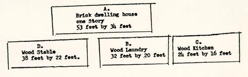 Figure 3.
1796 Insurance Policy.
Mutual Assurance Society Policy #971 Revaluation of buildings declared for Assurance by Samuel Griffin as per declaration No 177 September 5, 1809
"We the underwritten Robert Robert Anderson special agent and Francis Timberlake and Hunter Royle do hereby certify that we have viewed and revalued the buildings heretofore declared for assurance by Samuel Griffin then residing at Williamsburg in the county of James City in the Mutual Assurance Society against fire on buildings of the state of Virginia, We also certify that the said buildings are now owned by Samuel Griffin that they are now occupied by Elizabeth Gatliff that they are situated on Francis and Henry and two other streets—on the north lies [illegible]nant & others lots—East the Lunatic Hospital and Henry street South Abraham's lot and West the College and other lands... The Dwelling house Marked A at 3333 1/3 Dollars Say Three thousand three hundred thirty three & 1/3 Dollars.
| The Laundray | B at | 600 | Dollars Six Hundred Dollars. |
| The Kitchen | C at | 400 | Dollars four Hundred Dollars. |
| The Stable | D at | 333 1/3 | Dollars three hundred & thirty three & 1/3 Dollars. |
| 4666 2/3 | Say Four thousand six hundred & sixty six and two thirds Dollars in all." |
 Figure 4.
1809 Insurance Policy.
Mutual Assurance Society Policy #1515 Towns Revaluation July 8, 1815
"I the underwritten Ferdinand S. Campbell residing at Williamsburg in the county of James City do hereby declare for assurance in the Mutual Assurance Society against fire on buildings of the state of Virginia, my buildings on street in Williamsburg now occupied by myself situated between Streets on every side in the county of James City...
| The Dwelling Marked | A at 4000 Dollars Say | four thousand Dollars |
| The Laundry | B at 400 | four Hundred Dollars |
| The Kitchen | C at 400 | four Hundred Dollars |
| The Stable | D at 250 | two hundred & fifty Dollars |
| 5050 Say Five thousand and fifty Dollars, in all." |
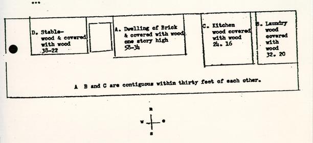 Figure 5.
1815 Insurance Policy.
Mutual Assurance Society Policy #5013 Revaluation of Building formerly declared for Assurance by Ferdinand S Campbell per Declaration No. 1515 April 17, 1823
"I the underwritten Ferdinand S Campbell residing at Williamsburg in the County of James City do hereby declare for Assurance in the MUTUAL ASSURANCE SOCIETY against fire on buildings of the state of Virginia my buildings on my wifes land now occupied by myself and situated between the streets of the city of Williamsburg on east, west, north and south in the county of James City...
| The Dwelling Marked | A at 1875 Dollars | Say Eighteen hundred & Seventy five Dollars. |
| The Laundry | B at 334 | Three hundred and thirty four Dollars. |
| The Kitchen | C at 267 | Two hundred and sixty seven Dollars. |
| The Stable | D at 150 | one hundred and fifty Dollars. |
| 2626 Say Two thousand Six hundred and twenty six dollars in all." |
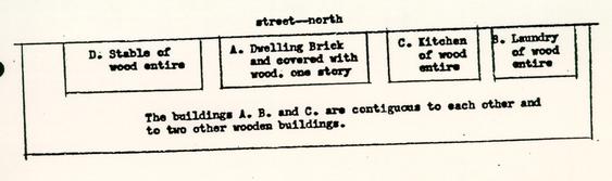 Figure 6.
1823 Insurance Policy.
Mutual Assurance Policy #7600 Revaluation of Buildings formerly declared for Assurance by Ferdinand S. Campbell per Declaration No. 5013 May 28, 1830
"I the underwritten Ferdinand Stewart Campbell Stewart residing at Williamsburg in the county of James City do hereby declare for Assurance in the MUTUAL ASSURANCE SOCIETY against Fire on Buildings of the State of Virginia, my buildings on streets in the city of Williamsburg E. W. M. and South now occupied by myself situated between the lots of the Lunatic Hospital East, and Adams' lot south in the county of James City...
| The Dwelling Marked | A at $2100 Say | Two thousand one hundred Dollars |
| The Laundry | B at 300 | Three Hundred Dollars |
| The Kitchen | C at 150 | One hundred and fifty Dollars |
| The Stable | D at 175 | One hundred and seventy five Dollars |
| $2725 | ||
| Say Two thousand Seven hundred and twenty five Dollars-" |
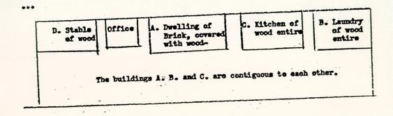 Figure 7.
1830 Insurance Policy.
Mutual Assurance Society Policy #11,015 Re-Valuation of Buildings declared for Assurance by Ferdinand S. C. Stewart as per Declaration No. 7600 April 24, 1839
"We the underwritten Robert Anderson, Special Agent, and Lucius P. Cary and Albert [faded]. Southall, Appraisers, do hereby certify, that we have viewed and re-valued the Buildings heretofore declared for Assurance, in the MUTUAL ASSURANCE SOCIETY against Fire on Buildings of the State of Virginia by Ferdinand S. C. Stewart as per his Declaration for Assurance Numbered 7600 That the said Buildings are at present owned by Ferdinand S. C. Stewart and wife residing at Philadelphia and are occupied by Ferdinand S. C. Stewart Junr That they are situated on the square of lots bounded on streets in every direction & in the City of Williamsburg in the county of ...
| The Dwelling Marked | A | at | $3000 | Say Three thousand Dollars |
| The Laundry | B | at | 350 | Three hundred and fifty do. |
| The Kitchen | C | at | 350 | Three hundred and fifty do. |
| $3700 | ||||
| Say Three thousand seven hundred Dollars in all." |
street on the south
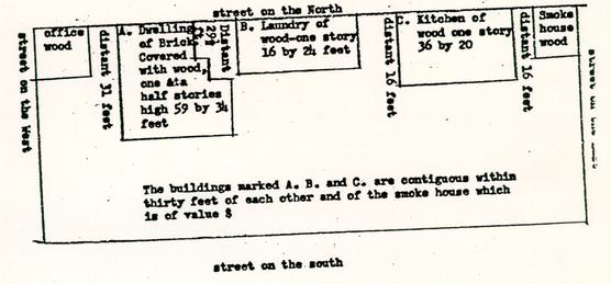 Figure 8.
1839 Insurance Policy.
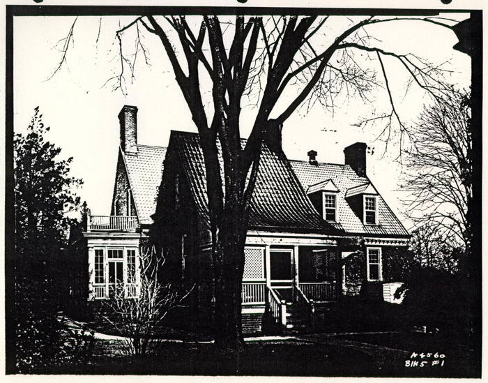 Figure 9. Griffin House. Photo N4560.
 Figure 10. Griffin House.
From Coleman Collection. Photo 75-NJI-430.
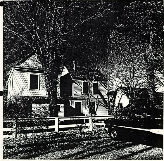 Figure 11. Frank Clark House.
East elevation. Photo 74-NJI-2534.
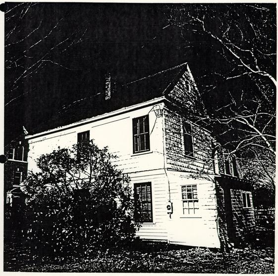 Figure 12. Frank Clark House.
Southeast corner. Photo 74-NJI-2535.
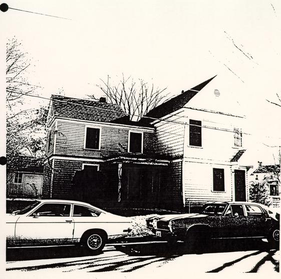 Figure 13. Frank Clark House.
West elevation. Photo 74-NJI-2536.
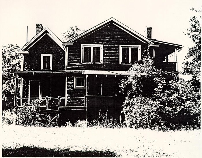 Figure 14. Anne Chapman House.
South elevation. Photo 60-JC-697-1.
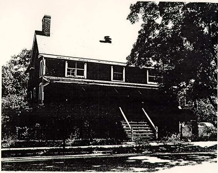 Figure 15. Anne Chapman House.
North elevation. Photo 60-JC-697-2.
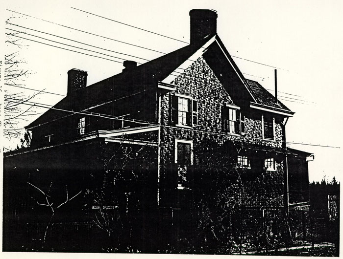 Figure 16. Anne Chapman House.
East elevation. Photo TB-195.
 Figure 17. Ida Davis House.
West elevation. Photo 51-T-1168.
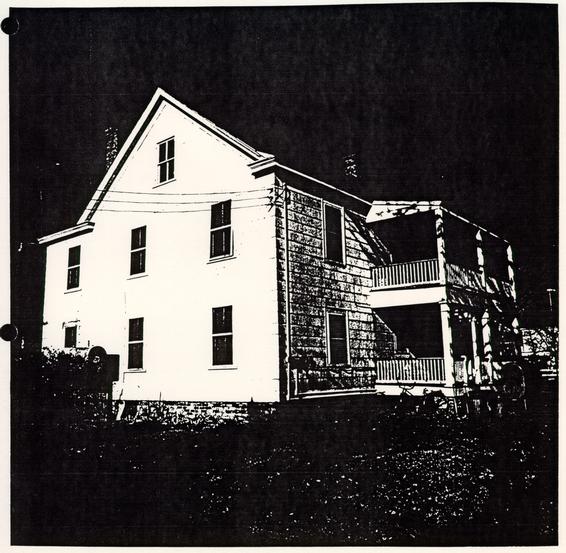 Figure 18. Jeanette Cowles House.
Southeast corner. Photo 74-NJI-2539.
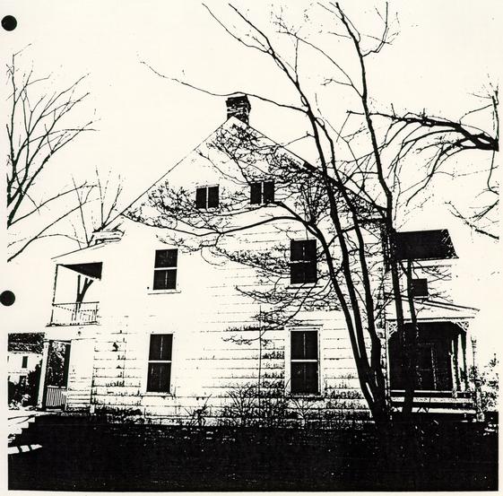 Figure 19. Jeanette Cowels House.
South elevation. Photo 74-NJI-2538.
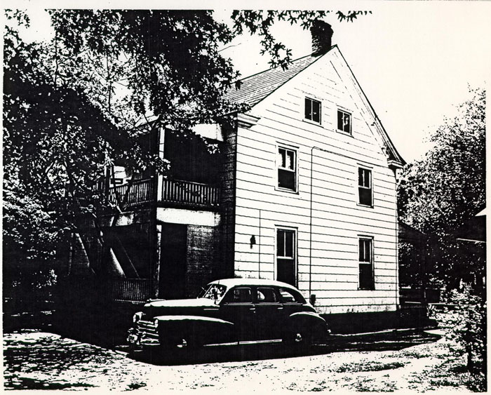 Figure 20. Jeanette Cowels House.
South elevation. Photo 51-T-1167.
 Figure 21. Jeanette Cowles House.
West elevation. Photo 74-NJI-2537.
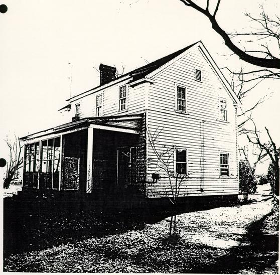 Figure 22. Thelma Brown House.
Northwest corner. Photo 74-NJI-2532.
 Figure 23. Thelma Brown House.
Southeast corner. Photo 74-NJI-2533.
 Figure 24. Thelma Brown House.
South elevation. Photo 51-T-1173.
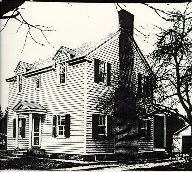 Figure 25. Thelma Brown House.
Southeast corner. Photo N2584.
 Figure 26. Thelma Brown House.
North elevation. Photo N2585.
Previous Archaeology
The only documentary reference to previous archaeology on Block 5 is in the January 1973 monthly archaeological report (Noel Hume 1973: 1), where it states:
...modern cisterns in the Block 5 parking area were examined. It was felt that none of these features warranted further exploration at this time.The block was apparently not thoroughly explored before the parking area was constructed. Most properties in the Historic Area were cross-trenched in order to locate foundations before any construction was begun, but on Block 5 this was apparently not the case.
While grading for an extension of the parking lot in 1983, a brick foundation was in fact discovered (Figure 27). Located about 40' southwest of Griffin Stable, it measured 4'0" x 4'2" and was set at about a 45 degree angle to the street (Samford 1983). The bricks were joined with sand mortar and partially capped with thin layer of concrete. This was then interpreted as part of a late 19th or 20th century manhole or brick septic tank. Based on very incomplete information, Adams (1983) later interpreted this as a possible Middle Plantation well house, but it now appears that the initial interpretation is correct.
A blueprint map prepared in 1954 (C.W.F. 1954) for the re-location of the Thelma Brown House shows a fence line and two 40-75' areas marked "old brick clay pit." These clay pits, in the southeastern quarter of the block, suggest the presence of a brick kiln on this part of the property.
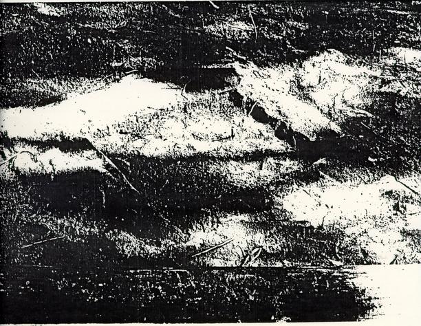 Figure 27. Modern manhole or brick septic tank.
Photo 83-4435s.
Map Research
Block 5 appears on the Frenchman's Map (1782) as a square block containing, on the northern edge, a rectangular building with two outbuildings on the east and two on the west (Figures 28 and 29). No other structures were mapped on the property, which was bounded on the east by "mill street." On both the Desandrouins Map (1782) and the Berthier Map (1782) the area is shown only as a "bland block" with no specific structural details (Figures 30, 31, and 32).
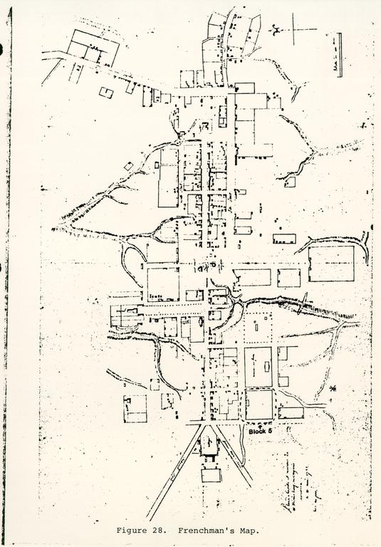 Figure 28. Frenchman's Map.
FROM FRENCHMAN'S MAP 1782?
SCALE-1"=100'
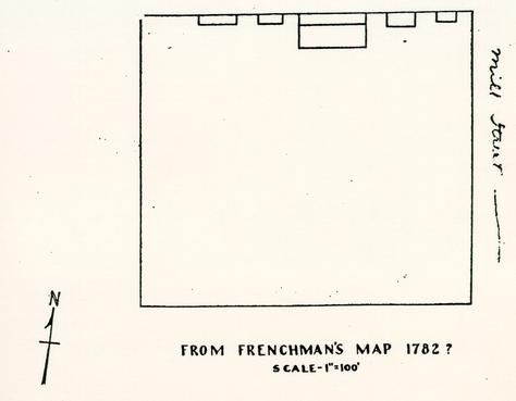 Figure 29. Detail of Frenchman's Map.
 Figure 30. Desandrouins Map.
 Figure 31. Detail of Deasndrouins Map.
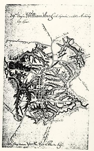 Figure 32. Berthier Map.
Archaeological Potential
Since archaeology has never been performed on this block, it holds tremendous potential for the investigation of a relatively little-known aspect of 18th century Williamsburg, the "urban plantation." This site form is not totally understood, though recent O.E.C. excavations on Block 44 at the Tazewell Hall site have revealed some information about architectural and landscape features. At Block 5 the number and location of dependency structures, the layout of the gardens and fields, and the original topography of the lots can possibly be ascertained through archaeology.
At Tazewell Hall a large parking area was stripped to reveal a graded surface behind the 18th century house. Although most of the cultural layers had been graded off when the parking lot was constructed, a number of deep archaeological features remained. Despite the disturbances caused by the 19th and 20th century houses, the landscaping of the parking islands, and the grading for the parking lot, it is likely that many traces of archaeological features are still left.
The northern half of the block probably contains the most evidence for the 18th century structures. Anticipated structures include a 22' x 38' stable, an office, a necessary, two outbuildings, a 20' x 32' laundry, a 16' x 24' kitchen, and a smokehouse, along with (possibly) a "shed room," a granary, and a well house. This part of the block probably also holds the greatest potential for large, stratigraphically-intact features, and should be the most closely investigated.
The southern half of the block should be stripped and given at least a cursory examination before it is destroyed. Landscape features such as postholes and garden beds may be present, as well as the "old brick clay pits" on the southeastern part of the block. These pits, which may be datable based on their artifactual content, are important evidence of possible craft activities, and should be examined carefully.
A detailed map showing current conditions and known and anticipated archaeological features has been prepared by Natalie F. Larson of the Office of Excavation and Conservation, and is appended to this report.
References
Adams, William H. 1983 Memorandum to Marley R. Brown III, regarding archaeological potential of Block 5, dated December 29, 1983. On file at the Office of Excavation and Conservation, Colonial Williamsburg Foundation.Colonial Williamsburg Foundation (C.W.F.) 1954 Relocation of Brown House to 413 Ireland Street. Blueprint map on file, Office of Excavation and Conservation, Colonial Williamsburg Foundation.
Gibbs, Pat 1984 Memorandum to Nicholas A. Pappas, regarding the Griffin House, dated January 17, 1984. On file at the Research Department, Colonial Williamsburg Foundation.
Noel Hume, Ivor 1973 Monthly Report on Archaeological Activities: January 1973. On file at the Office of Excavation and Conservation, Colonial Williamsburg Foundation.
Samford, Patricia M. 1983 Monitoring report: Block 5, Bldg. 2 (Griffin Stable). On file at the Office of Excavation and Conservation, Colonial Williamsburg Foundation.
Stephenson, Mary A. 1960 Griffin House: Block 5, Colonial Lots 64-71, Francis Street. Research report on file at the Research Department, Colonial Williamsburg Foundation.
SUMMARY SHEET - KNOWN ARCHAEOLOGICAL FEATURES
BLOCK 5
CATALOGUE #: 5
FEATURE:
Griffin House (Bldg. 1).
DESCRIPTION:
34' x 58' brick dwelling with front and back porches. Restored and now used as office space.
LOCATION:
On Francis Street in center of north side of block.
ASSOCIATED ARTIFACTS REPORTED:
None known.
REPORTED DISPOSITION OF ARTIFACTS:
Not applicable.
CURRENT COLLECTION STATUS:
Not applicable.
INVESTIGATOR(S):
None known.
CONDITION:
Restored and still standing. No known excavation.
PAST INTERPRETATION AND SIGNIFICANCE:
Dwelling built circa 1771 by William Allen. Once town house of William Byrd III, later owned by Samuel Griffin.
EXCAVATION TECHNIQUE:
Not excavated.
REFERENCES:
Block and Building Book: Block 5, Bldg. 1.
| Mutual Assurance Society policies: | # 177 (1796). |
| # 971 (1809). | |
| # 1515 (1815). | |
| # 5013 (1823). | |
| # 7600 (1830). | |
| # 11,015 (1839). |
| Sanborn maps: | 1921. |
| 1929. | |
| 1933. | |
| Photos: | N4560. |
| 75-NJI-430. |
FEATURE:
Griffin Stable (Bldg. 2).
DESCRIPTION:
32' x 44' reconstructed stable now used as office space.
LOCATION:
84' south of Griffin House.
ASSOCIATED ARTIFACTS REPORTED:
None known.
REPORTED DISPOSITION OF ARTIFACTS:
Not applicable.
CURRENT COLLECTION STATUS:
Not applicable.
INVESTIGATOR (S):
None known.
CONDITION:
Reconstructed and still standing. No known excavation.
PAST INTERPRETATION AND SIGNIFICANCE:
Interpeted as Griffin Stable. Probably not on original location.
EXCAVATION TECHNIQUE:
Not excavated.
REFERENCES:
Block and Building Book: Block 5, Bldg. 2.
| Sanborn maps: | 1921. |
| 1929. | |
| 1933. |
FEATURE:
Griffin Greenhouse (Bldg. 3).
DESCRIPTION:
22' x 60' rectangular building formerly used as greenhouse. Built early in 20th century.
LOCATION:
Northeastern corner is 72' southwest of southwestern corner of Griffin Stable.
ASSOCIATED ARTIFACTS REPORTED:
None known.
REPORTED DISPOSITION OF ARTIFACTS:
Not applicable.
CURRENT COLLECTION STATUS:
Not applicable.
INVESTIGATOR (S):
None known.
CONDITION:
Torn down in 1948.
PAST INTERPRETATION AND SIGNIFICANCE:
Used as greenhouse. No archaeological evidence for its earlier existence.
EXCAVATION TECHNIQUE:
Not excavated.
REFERENCES:
Sanborn map: 1929.
FEATURE:
Frank Clark House (Bldg. 4).
DESCRIPTION:
Approximately 36' x 36' house. Built early in 20th century.
LOCATION:
On Boundary Street, 90' south of Chapman House.
ASSOCIATED ARTIFACTS REPORTED:
None known.
REPORTED DISPOSITION OF ARTIFACTS:
Not applicable.
CURRENT COLLECTION STATUS:
Not applicable.
INVESTIGATOR(S):
None known.
CONDITION:
Torn down in March 1975.
PAST INTERPRETATION AND SIGNIFICANCE:
Dwelling used in 20th century.
EXCAVATION TECHNIQUE:
Not excavated.
REFERENCES:
| Sanborn maps: | 1921. |
| 1929. | |
| 1933. | |
| Photos: | 74-NJI-2534. |
| 74-NJI-2535. | |
| 74-NJI-2536. |
FEATURE:
Frank Clark Outbuilding (Bldg. 4A).
DESCRIPTION:
Small outbuilding near Frank Clark House. Built early in 20th century.
LOCATION:
Southeast of Frank Clark House.
ASSOCIATED ARTIFACTS REPORTED:
None known.
REPORTED DISPOSITION OF ARTIFACTS:
Not applicable.
CURRENT COLLECTION STATUS:
Not applicable.
INVESTIGATOR(S):
None known.
CONDITION:
Torn down in March 1975.
PAST INTERPRETATION AND SIGNIFICANCE:
Outbuilding used in 20th century.
EXCAVATION TECHNIQUE:
Not excavated.
REFERENCES:
Sanborn map: 1933.
FEATURE:
Storage building (Bldg. 5).
DESCRIPTION:
Rectangular storage building. Built early in 20th century.
LOCATION:
On Boundary Street, northwest of Frank Clark House.
ASSOCIATED ARTIFACTS REPORTED:
None known.
REPORTED DISPOSITION OF ARTIFACTS:
Not applicable.
CURRENT COLLECTION STATUS:
Not applicable.
INVESTIGATOR(S):
None known.
CONDITION:
Torn down around 1940.
PAST INTERPRETATION AND SIGNIFICANCE:
Storage building used in 20th century.
EXCAVATION TECHNIQUE:
Not excavated.
REFERENCES:
| Sanborn maps: | 1921. |
| 1929. |
FEATURE:
Storage building (Bldg. 6).
DESCRIPTION:
Rectangular storage building. Built early in 20th century.
LOCATION:
On Boundary Street, south of Chapman House and north of storage building 5.
ASSOCIATED ARTIFACTS REPORTED:
None known.
REPORTED DISPOSITION OF ARTIFACTS:
Not applicable.
CURRENT COLLECTION STATUS:
Not applicable.
INVESTIGATOR (S):
None known.
CONDITION:
Torn down around 1940.
PAST INTERPRETATION AND SIGNIFICANCE:
Storage building used in 20th century.
EXCAVATION TECHNIQUE:
Not excavated.
REFERENCES:
| Sanborn maps: | 1921. |
| 1929. |
FEATURE:
Anne Chapman House (Bldg. 7).
DESCRIPTION:
32' x 42' house. Built in early 20th century.
LOCATION:
Northwestern corner of block, 153' west of Griffin House.
ASSOCIATED ARTIFACTS REPORTED:
None known.
REPORTED DISPOSITION OF ARTIFACTS:
Not applicable.
CURRENT COLLECTION STATUS:
Not applicable.
INVESTIGATOR (S):
None known.
CONDITION:
Torn down in August 1960.
PAST INTERPRETATION AND SIGNIFICANCE:
Dwelling used in 20th century. Used as temporary facility for William and Mary students in 1956.
EXCAVATION TECHNIQUE:
Not excavated.
REFERENCES:
| Sanborn maps: | 1921. |
| 1929. | |
| 1933. | |
| Photos: | 60-JC-697-1. |
| 60-JC-697-2. | |
| TB-195. |
FEATURE:
Ida Davis House (Bldg. 8).
DESCRIPTION:
25' x 32' house with back porch. Moved from Block 15 in 1929.
LOCATION:
On Boundary Street, 58' south of Clarke House.
ASSOCIATED ARTIFACTS REPORTED:
None known.
REPORTED DISPOSITION OF ARTIFACTS:
Not applicable.
CURRENT COLLECTION STATUS:
Not applicable.
INVESTIGATOR (S):
None known.
CONDITION:
Torn down in 1969.
PAST INTERPRETATION AND SIGNIFICANCE:
Dwelling used in 20th century. Formerly Block 15, Bldg. 29.
EXCAVATION TECHNIQUE:
Not excavated.
REFERENCES:
| Sanborn map: | 1933. |
| Photo: | 51-T-1168. |
FEATURE:
Ida Davis Woodshed (Bldg. 8A).
DESCRIPTION:
Small outbuilding near the Ida Davis House. Built early in 20th century.
LOCATION:
East of Ida Davis House.
ASSOCIATED ARTIFACTS REPORTED:
None known.
REPORTED DISPOSITION OF ARTIFACTS:
Not applicable.
CURRENT COLLECTION STATUS:
Not applicable.
INVESTIGATOR (S):
None known.
CONDITION:
Torn down in 1969.
PAST INTERPRETATION AND SIGNIFICANCE:
Outbuilding used in 20th century.
EXCAVATION TECHNIQUE:
Not excavated.
REFERENCES:
Sanborn maps: 1933.
FEATURE:
R.L. Griffin House (Bldg. 9).
DESCRIPTION:
20' x 30' house. Moved from Block 15 in 1929.
LOCATION:
On Boundary Street, 29' south of Davis House.
ASSOCIATED ARTIFACTS REPORTED:
None known.
REPORTED DISPOSITION OF ARTIFACTS:
Not applicable.
CURRENT COLLECTION STATUS:
Not applicable.
INVESTIGATOR (S):
None known.
CONDITION:
Torn down in September 1963.
PAST INTERPRETATION AND SIGNIFICANCE:
Dwelling used in 20th century. Formerly Block 15, Bldg. 30.
EXCAVATION TECHNIQUE:
Not excavated.
REFERENCES:
Sanborn map: 1933.
FEATURE:
R.L. Griffin Woodshed (Bldg. 9A).
DESCRIPTION:
Small outbuilding near R.L. Griffin House. Built early in 20th century.
LOCATION:
East of R.L. Griffin House.
ASSOCIATED ARTIFACTS REPORTED:
None known.
REPORTED DISPOSITION OF ARTIFACTS:
Not applicable.
CURRENT COLLECTION STATUS:
Not applicable.
INVESTIGATOR (S):
None known.
CONDITION:
Torn down in September 1963.
PAST INTERPRETATION AND SIGNIFICANCE:
Outbuilding used in 20th century.
EXCAVATION TECHNIQUE:
Not excavated.
REFERENCES:
Sanborn maps: 1933.
FEATURE:
Jeanette Cowles House (Bldg. 10).
DESCRIPTION:
34' x 36' house with porch. Moved from Block 15 in 1929.
LOCATION:
On Boundary Street, 30' south of R.L. Griffin House.
ASSOCIATED ARTIFACTS REPORTED:
None known.
REPORTED DISPOSITION OF ARTIFACTS:
Not applicable.
CURRENT COLLECTION STATUS:
Not applicable.
INVESTIGATOR(S):
None known.
CONDITION:
Torn down in July 1975.
PAST INTERPRETATION AND SIGNIFICANCE:
Dwelling used in 20th century. Formerly Block 15, Bldg. 31.
EXCAVATION TECHNIQUE:
Not excavated.
REFERENCES:
| Sanborn map: | 1933. |
| Photos: | 74-NJI-2537. |
| 74-NJI-2539. | |
| 74-NJI-2538. | |
| 51-T-1167. |
FEATURE:
Jeanette Cowles Woodshed (Bldg. 10A).
DESCRIPTION:
Small outbuilding near Jeanette Cowles House. Built early in 20th century.
LOCATION:
East of Jeanette Cowles House.
ASSOCIATED ARTIFACTS REPORTED:
None known.
REPORTED DISPOSITION OF ARTIFACTS:
Not applicable.
CURRENT COLLECTION STATUS:
Not applicable.
INVESTIGATOR(S):
None known.
CONDITION:
Torn down in July 1975.
PAST INTERPRETATION AND SIGNIFICANCE:
Outbuilding used in 20th century.
EXCAVATION TECHNIQUE:
Not excavated.
REFERENCES:
Sanborn maps: 1933.
FEATURE:
Travis House (Bldg. 11).
DESCRIPTION:
28' x 75' house. Moved from Block 13 in 1951.
LOCATION:
On Francis Street, 15' east of Griffin House.
ASSOCIATED ARTIFACTS REPORTED:
None known.
REPORTED DISPOSITION OF ARTIFACTS:
Not applicable.
CURRENT COLLECTION STATUS:
Not applicable.
INVESTIGATOR(S):
None known.
CONDITION:
Moved to Block 14 in 1968.
PAST INTERPRETATION AND SIGNIFICANCE:
Reconstructed 18th century building. Formerly Block 13, Bldg. 23-A. Now Block 14, Bldg. 4.
EXCAVATION TECHNIQUE:
Not excavated.
REFERENCES:
Map: "Map of Williamsburg, Va.," C.W.F., revised 1963.
SUMMARY SHEET - KNOWN ARCHAEOLOGICAL FEATURES
BLOCK 5
CATALOGUE #: 5
FEATURE:
Thelma Brown House (Bldg. 12).
DESCRIPTION:
30' x 32' house. Moved from Block 15 in 1942.
LOCATION:
20' south of Griffin Greenhouse.
ASSOCIATED ARTIFACTS REPORTED:
None known.
REPORTED DISPOSITION OF ARTIFACTS:
Not applicable.
CURRENT COLLECTION STATUS:
Not applicable.
INVESTIGATOR (S):
None known.
CONDITION:
Relocated in July 1975.
PAST INTERPRETATION AND SIGNIFICANCE:
Dwelling used in 20th century. Formerly Block 15, Bldg. 1.
EXCAVATION TECHNIQUE:
Not excavated.
REFERENCES:
Map: "Map of Williamsburg, Va.," C.W.F., April 1942.
Photos: 74-NJI-2532.
74-NJI-2533.
51-T-1173.
N2584.
N2585.
FEATURE:
Frame structure.
DESCRIPTION:
Single story frame structure.
LOCATION:
Facing on Francis Street, a few feet from street. Possibly across street on Block 15.
ASSOCIATED ARTIFACTS REPORTED:
None known.
REPORTED DISPOSITION OF ARTIFACTS:
Not applicable.
CURRENT COLLECTION STATUS:
Not applicable.
INVESTIGATOR(S):
None known.
CONDITION:
Torn down in 1890.
PAST INTERPRETATION AND SIGNIFICANCE:
Based on recollection of town at time of Civil War.
EXCAVATION TECHNIQUE:
Not excavated.
REFERENCES:
Oral history: "Recollections of Williamsburg," John S. Charles, 1933.
FEATURE:
Manhole or brick septic tank.
DESCRIPTION:
4'0" x 4'2" brick foundation with sand mortar. Set at 45 degree angle to the street. Covered with a thin layer of concrete.
LOCATION:
40' southwest of Griffin Stable.
ASSOCIATED ARTIFACTS REPORTED:
None known.
REPORTED DISPOSITION OF ARTIFACTS:
Not applicable.
CURRENT COLLECTION STATUS:
Not applicable.
INVESTIGATOR(S):
Patricia M. Samford (1983).
CONDITION:
Partially excavated and later covered with concrete cap.
PAST INTERPRETATION AND SIGNIFICANCE:
Interpreted as late 19th or 20th century feature.
EXCAVATION TECHNIQUE:
Discovered during grading for parking lot and cleared to expose brickwork.
REFERENCES:
Monitoring report, Patricia M. Samford, September 1, 1983. Photo: 83-4435s.
FEATURE:
Brick clay pit.
DESCRIPTION:
30' x 90' "old brick clay pit."
LOCATION:
Approximately 35' east of Thelma Brown House.
ASSOCIATED ARTIFACTS REPORTED:
None known.
REPORTED DISPOSITION OF ARTIFACTS:
Not applicable.
CURRENT COLLECTION STATUS:
Not applicable.
INVESTIGATOR (S):
Unknown, possibly "W.B."
CONDITION:
Unknown. Discovered during while relocating Thelma Brown House.
PAST INTERPRETATION AND SIGNIFICANCE:
Interpreted as brick kiln.
EXCAVATION TECHNIQUE:
Unknown.
REFERENCES:
Map: "Relocation of Brown House to 413 Ireland Street," drafted by W.B., August 26, 1954.
FEATURE:
Brick clay pit.
DESCRIPTION:
35' x 42' "old brick clay pit."
LOCATION:
127' east of Thelma Brown House and 24' northeast of other brick clay pit.
ASSOCIATED ARTIFACTS REPORTED:
None known.
REPORTED DISPOSITION OF ARTIFACTS:
Not applicable.
CURRENT COLLECTION STATUS:
Not applicable.
INVESTIGATOR (S):
Unknown, possibly "W.B."
CONDITION:
Unknown. Discovered while relocating Thelma Brown House.
PAST INTERPRETATION AND SIGNIFICANCE:
Interpreted as brick kiln.
EXCAVATION TECHNIQUE:
Unknown.
REFERENCES:
Map: "Relocation of Brown House to 413 Ireland Street," drafted by W.B., August 26, 1954.
FEATURE:
"Shed room."
DESCRIPTION:
No description given in documentary sources.
LOCATION:
No location given in documentary sources.
ASSOCIATED ARTIFACTS REPORTED:
None known.
REPORTED DISPOSITION OF ARTIFACTS:
Not applicable.
CURRENT COLLECTION STATUS:
Not applicable.
INVESTIGATOR (S):
None known.
CONDITION:
Unknown. Not excavated.
PAST INTERPRETATION AND SIGNIFICANCE:
Interpreted from records of repairs to property.
EXCAVATION TECHNIQUE:
Not excavated.
REFERENCES:
Documentary records: repairs to Griffin property, 1784.
FEATURE:
"Granary."
DESCRIPTION:
No description given in documentary sources.
LOCATION:
No location given in documentary sources.
ASSOCIATED ARTIFACTS REPORTED:
None known.
REPORTED DISPOSITION OF ARTIFACTS:
Not applicable.
CURRENT COLLECTION STATUS:
Not applicable.
INVESTIGATOR(S):
None known.
CONDITION:
Unknown. Not excavated.
PAST INTERPRETATION AND SIGNIFICANCE:
Interpreted from records of repairs to property.
EXCAVATION TECHNIQUE:
Not excavated.
REFERENCES:
Documentary records: repairs to Griffin property, 1786.
FEATURE:
Stable.
DESCRIPTION:
21' x 38' outbuilding. Probably destroyed between 1852 and 1860.
LOCATION:
100' west of Griffin House.
ASSOCIATED ARTIFACTS REPORTED:
None known.
REPORTED DISPOSITION OF ARTIFACTS:
Not applicable.
CURRENT COLLECTION STATUS:
Not applicable.
INVESTIGATOR(S):
None known.
CONDITION:
Unknown. Not excavated.
PAST INTERPRETATION AND SIGNIFICANCE:
Location interpreted from insurance maps.
EXCAVATION TECHNIQUE:
Not excavated.
REFERENCES:
| Mutual Assurance Society policies: | # 177 (1796). |
| # 971 (1809). | |
| # 1515 (1815). | |
| # 5013 (1823). | |
| # 7600 (1830). |
FEATURE:
Office.
DESCRIPTION:
16' x 28' outbuilding.
LOCATION:
Interpreted as 30' west of Griffin House and 10' north of necessary.
ASSOCIATED ARTIFACTS REPORTED:
None known.
REPORTED DISPOSITION OF ARTIFACTS:
Not applicable.
CURRENT COLLECTION STATUS:
Not applicable.
INVESTIGATOR(S):
None known.
CONDITION:
Unknown. Not excavated.
PAST INTERPRETATION AND SIGNIFICANCE:
Location interpreted from insurance maps.
EXCAVATION TECHNIQUE:
Not excavated.
REFERENCES:
| Mutual Assurance Society policies: | # 971 (1809) (?). |
| 7600 (1830). | |
| 11,015 (1839). |
FEATURE:
Necessary.
DESCRIPTION:
10' x 14' outbuilding.
LOCATION:
Interpreted as 38' west of Griffin House.
ASSOCIATED ARTIFACTS REPORTED:
None known.
REPORTED DISPOSITION OF ARTIFACTS:
Not applicable.
CURRENT COLLECTION STATUS:
Not applicable.
INVESTIGATOR(S):
None known.
CONDITION:
Unknown. Not excavated.
PAST INTERPRETATION AND SIGNIFICANCE:
Location interpreted from insurance map.
EXCAVATION TECHNIQUE:
Not excavated.
REFERENCES:
Mutual Assurance Society policy: # 971 (1809).
FEATURE:
Outbuilding.
DESCRIPTION:
5' x 8' outbuilding.
LOCATION:
Interpreted as 84' east of Griffin House and 15' south of laundry.
ASSOCIATED ARTIFACTS REPORTED:
None known.
REPORTED DISPOSITION OF ARTIFACTS:
Not applicable.
CURRENT COLLECTION STATUS:
Not applicable.
INVESTIGATOR(S):
None known.
CONDITION:
Unknown. Not excavated.
PAST INTERPRETATION AND SIGNIFICANCE:
Location interpreted from insurance map.
EXCAVATION TECHNIQUE:
Not excavated.
REFERENCES:
Mutual Assurance Society policy: # 971 (1809).
FEATURE:
Outbuilding.
DESCRIPTION:
5' x 8' outbuilding.
LOCATION:
Interpreted as 84' east of Francis Street and 8' south of laundry.
ASSOCIATED ARTIFACTS REPORTED:
None known.
REPORTED DISPOSITION OF ARTIFACTS:
Not applicable.
CURRENT COLLECTION STATUS:
Not applicable.
INVESTIGATOR(S):
None known.
CONDITION:
Unknown. Not excavated.
PAST INTERPRETATION AND SIGNIFICANCE:
Location interpreted from insurance map.
EXCAVATION TECHNIQUE:
Not excavated.
REFERENCES:
Mutual Assurance Society policy: # 971 (1809).
FEATURE:
Laundry.
DESCRIPTION:
16' x 24' outbuilding.
LOCATION:
Interpreted as 74' east of Griffin House facing Francis Street.
ASSOCIATED ARTIFACTS REPORTED:
None known.
REPORTED DISPOSITION OF ARTIFACTS:
Not applicable.
CURRENT COLLECTION STATUS:
Not applicable.
INVESTIGATOR(S):
None known.
CONDITION:
Unknown. Not excavated.
PAST INTERPRETATION AND SIGNIFICANCE:
Location interpreted from insurance maps.
EXCAVATION TECHNIQUE:
Not excavated.
REFERENCES:
| Mutual Assurance Society policies: | # 177 (1796). |
| 971 (1809). | |
| 1515 (1815). | |
| 5013 (1823). | |
| 7600 (1830). | |
| 11,015 (1839). |
FEATURE:
Kitchen.
DESCRIPTION:
18' x 31' outbuilding.
LOCATION:
Interpreted as 28' east of Griffin House facing Francis Street.
ASSOCIATED ARTIFACTS REPORTED:
None known.
REPORTED DISPOSITION OF ARTIFACTS:
Not applicable.
CURRENT COLLECTION STATUS:
Not applicable.
INVESTIGATOR(S):
None known.
CONDITION:
Unknown. Not excavated.
PAST INTERPRETATION AND SIGNIFICANCE:
Location interpreted from insurance maps.
EXCAVATION TECHNIQUE:
Not excavated.
REFERENCES:
| Mutual Assurance Society policies: | # 177 (1796). |
| 971 (1809). | |
| 1515 (1815). | |
| 5013 (1823). | |
| 7600 (1830). | |
| 11,015 (1839). |
FEATURE:
Smokehouse.
DESCRIPTION:
LOCATION:
ASSOCIATED ARTIFACTS REPORTED:
None known.
REPORTED DISPOSITION OF ARTIFACTS:
Not applicable.
CURRENT COLLECTION STATUS:
Not applicable.
INVESTIGATOR(S):
None known.
CONDITION:
Unknown. Not excavated.
PAST INTERPRETATION AND SIGNIFICANCE:
Location interpreted from insurance map.
EXCAVATION TECHNIQUE:
Not excavated.
REFERENCES:
Mutual Assurance Society policy: # 11,015 (1839).