David Morton House Architectural
Report, Block 7 Building 15A-E Lot 23Originally entitled:
"Architectural Report:
David Morton House and Outbuildings,
Block 7, Buildings 15A, B, C, D, E, Colonial Lot Number 23"
Colonial Williamsburg Foundation Library
Research Report Series - 1092
Colonial Williamsburg Foundation
Library
Williamsburg, Virginia
1990
ARCHITECTURAL REPORT
DAVID MORTON HOUSE AND OUTBUILDINGS
Block 7, Buildings 15A, B, C, D, E
Colonial Lot Number 23 A reconstruction of a late eighteenth
century frame dwelling based upon
Historical evidence and archaeological investigation.
Reconstruction begun August 1953
Architectural Design
Mario E. Campioli, Director of Architecture
Ernest M. Frank, Assistant Director of Architecture
Roy Cava, Squad Boss
Roger Pitts, Architectural Draftsman
George Bennett, Architectural Draftsman
Landscape Architecture
Alden Hopkins, Resident Landscape Architecture
Don Parker, Landscape Draft6man
William Barton, Landscape Draftsman
Mechanical Engineering
Tom Drewry, Resident Mechanical Engineer
Construction Supervision
Joe Jenkins, Laison and Specifications Writer
Construction Superintendent
Architectural Report
Orin M. Bullock, Supervisor of Architectural Research
LIST OF PLATES
| No. | Title |
|---|---|
| 1. | Finished Photograph - David Morton House |
| 2. | Frenchman's Map - Showing Site |
| 3. | Prototypes - Moody House and Liberty Hall |
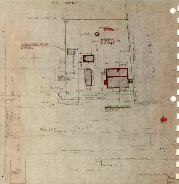
| 3-A. | Location Plan |
| 4. | Archaeological Plan |
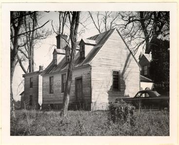
| 4-A. | Photographs of Original Foundations |
| 5. | North and South Elevations - Morton House |
| 6. | East and West Elevations - Morton House |
| 7. | First and Second Floor Plans - Morton House |
| 8. | Foundation and Basement Plans - Morton House |
| 9. | Cross Section - Morton House |
| 10. | Details of Crown Mouldings and Nosings |
| 11. | Details of Miscellaneous Mouldings |
| 12. | Kitchen of Morton House |
| 13. | Morton Shop |
| 13-A. | Morton Shop Detail |
| 14. | Morton Necessary House |
| 15. | Morton Necessary House Elevations |
| 16. | Morton Well Head |
| 17. | Morton Walks and Paths |
| 18. | Morton Planting |
 From Frenchman's Map 1782?
HISTORICAL FACTS
The first documentary evidence of occupancy of the site was found in the Virginia Gazette in 1767. On January 15, Benjamin Waller advertised a tenement for rent between Mr. Lewis' Store and Mrs. Vobe's Tavern, on October 4, William Lewis advertised Kendal Cottons etc. "… at the corner store a little below the Capitol… " and on November 1, the property next door, described "…House and Lot where Mrs. Steel formerly lived just below Mr. Lewis' store…" was offered for sale.
The property was apparently rented to Mr. Lewis by Benjamin Waller who sold it to David Morton on November 10, 1777 transfering " …houses palings, yards, gardens … "
The corner lot remained in the name of David Morton or his estate until 1820 even though he sold a 35.5 foot strip off the north side in 1778.
Records of Humphrey Harwood, Carpenter and Builder, indicate numerous minor repairs to the buildings on the property from 1776 to 1789. One of the most significant, in 1782, "… white washing 3 rooms and a passage… " confirms the plan arrangement of the first floor which may be deduced from the archaeological evidence.
The house was burned "…some time after the [civil] war…" according to the recollections of Mr. Charles, an old resident of Williamsburg writing in 1928. Mr. Charles described the house as of frame, facing on Waller Street with cellar steps on York Street. He also recalled it as "…a two story frame house with a vine clad porch … . " It appears that Mr. Charles did not differentiate between 1½ story and 2 story because Humphrey Harwood records repairing 2 lathing and plastering of dormer windows in July, 1785.
The site was not built upon again until the reconstruction of the Morton House but was used as pasture and gardens.
Archaeological excavations revealed the existence of foundations for a building 32 feet wide (north and south) and 30 foot½inch deep (east and west) with a full cellar 2 to 2½ feet below natural grade, two chimneys, one apparently for a corner chimney on the east side, and basement bulkhead entrances, one on York Street and one on the north wall, east section. The brickwork to the east while apparently eighteenth century was obviously of later construction than that of the west.
DESIGN CONCEPT
On the basis of the Historical facts we believe the David Morton house was not unlike Liberty Hall, Essex County, Virginia insofar as the front elevation and plan was concerned. The foundation dimensions and conjectural plan developed from them is almost identical to that of Liberty Hall.
On the assumption that the eastern addition was almost contemporary with the main portion, the end or gable elevation may have been like the Moody House (formerly Roper-Lee House of Williamsburg). This form not unlike the "salt box" roofs in New England is not quite as usual in Virginia an the more obvious lean-to type.
Both Liberty Hall and the Moody House are 1½ story frame buildings and presented this form in the latter part of the eighteenth century.
THE EXTERIOR
The form and general proportion of the building is an
accurate
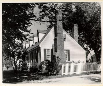 photo N 6713 Moody House Block 2 Bldg 31
 EMF neg. Liberty Hall, Essex
3
reconstruction utilizing reproductions of the various
details noted on the following illustrations. The location of all doors, steps,
and windows as well as the size of the building was established by original
evidence supplemented by the knowledge of the similarity in detail of eighteenth
century buildings of similar size, use, and date.
EMF neg. Liberty Hall, Essex
3
reconstruction utilizing reproductions of the various
details noted on the following illustrations. The location of all doors, steps,
and windows as well as the size of the building was established by original
evidence supplemented by the knowledge of the similarity in detail of eighteenth
century buildings of similar size, use, and date.
THE INTERIOR
The arrangement of rooms in plan was established by the location of foundations found in site. An almost identical basic plan is found at Liberty Hall, Essex County, Virginia.
The basic plan has been modified in detail to meet the requirements of a modern residence. The modifications being:
- 1.The subdivision of the ground floor in to several rooms, the original ground floor was basement having two or possibly three rooms and was probably used only for storage.
- 2. The subdivision of one of the first floor rooms to provide a bath and closets, the original plan no doubt had but 3 rooms and a stair hall.
- 3. The subdivision of the second floor to provide a bath and closets, the original plan no doubt had a stair hall and one room.
As a further concession to use as a residence the house is equipped with electricity and is provided with radiant steam heat concealed in the floors and ceilings. These systems are fully described in the specifications and indicated on working drawings.
The window sash, both upper and lower are operable on weights and pulleys. Such operation was not unknown in the eighteenth century but houses of this size and character seldom had counter balanced sash and usually only the lower sash was operable.
The hardware is basically a reproduction of eighteenth century handmade wrought iron work. The several pieces are described in 4 detail in the hardware schedule of the specification.
Painting and decorating both inside and outside conforms to the taste and custom commonly used on similar houses of the period. The detail of the colors and their application is shown on the painting schedule in the specification.
All materials used in the reconstruction are new and their species are given in the specifications. Construction methods for all concealed features adhere to the very beat modern practice. All exposed features (moldings, trim, mantels, etc.) are reproductions of specific eighteenth century examples as noted on the following illustration or careful adaptations of eighteenth century prototypes.
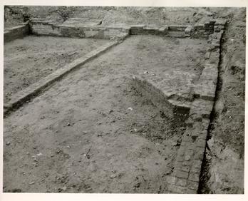
ARCHAEOLOGY
The Archaeological Excavation of Lot 23, Block 7 was done under the direction of James M. Knight in May, 1953 as is recorded as Archaeological Excavation Bk. 7, Area B, N.E. Corner of Waller and York Streets.
Foundations found are shown on plate IV*. The drawing known as the "Frenchman's Map", circa 1785, indicates three buildings on this corner which correspond in location to the "Morton House," "Shop," and "Kitchen." The "Frenchman" indicates both the Shop and Kitchen as roughly square buildings but the evidence of the excavations proves that he was probably careless in delineating the shape of the Shop. He shows the Morton House as a rectangle, probably recording its shape prior to the addition to the east.
The brick in the foundations walls of House and Kitchen were a mixture of dark and light red; 8¼" x 4" x 2¾"; those in the Kitchen were 7¾"-8" x 3 5/8" x 2½"-2 5/8"; the brick in the Shop were buff and light red, 9 5/8" x 4 5/8" x 2½"; all were laid in oyster shell lime mortar and the differences in age or date of laying could not be determined. All appeared to be eighteenth century.
THE MORTON HOUSE
The foundation of the House was laid in two stages, the front or west portion 32'-0" (north and south) x 17'-11½" (east and west) was laid in English bond. The west portion, extending the entire length of the front portion, is 12'-1" wide (east and west) 6 and was laid in a careless bond with many discarded broken brick.
The basement under the front, or earlier portion of the House, was excavated to approximately 2'-6" below natural grade and was provided access via a brick-wood nose stepped bulkhead on the south wall. The rear portion was excavated approximately 2'-0" below natural grade and was provided access via a more recent bulkhead on the north. There was no apparent connection between the two basement areas.
No evidence of the construction above the foundation walls could be determined from the excavation. The presence in the excavated material of same evidences of burned wood might indicate the former existence of a frame building but no details could be deduced. The artifacts recovered were grouped with those from the excavation of the Jackson site, Lot 24, the two lots being included in archaeological excavation Bk. 7, Area B.
The artifacts recovered include:
| Ceramics | Stoneware, | 16 pc 84 oz. Early Brown |
| 1 pc½oz. White salt glaze | ||
| 51 pc 215 oz. 19th century | ||
| Porcelain, | 2 pc 2 oz. English | |
| Earthware, | 1 pc 4½ oz. Crude (early) | |
| 1 pc 2 oz. Slipware (early) | ||
| 3 pc 9 oz. Wheildon (middle) | ||
| 11 pc 19½oz. Blue & Green Edge (middle) | ||
| 1 pc½oz. Hand paint. Staffordshire (late) | ||
| 6 pc 6½oz. Transfer paint Staffordshire (Late) | ||
| Metal | Iron, | 6 pc Tools and Implements |
| 10 pc Household hardware | ||
| 7 | ||
| 3 pc Nails & Spikes | ||
| 8 pc Hinges | ||
| 11 pc Locks and Keys | ||
| 1 pc Miscellaneous Iron | ||
| Brass, | 1 pc Buckle | |
| 1 pc Wine Cock | ||
| 1 pc Cabinet Hardware | ||
| 1 pc Candlestick | ||
| 1 pc Household Utensil | ||
Glass fragments were those of the late 18th and 19th century and were found in average quantities.
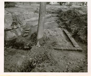
MORTON SHOP
Only fragmentary portions of foundations were found but careful excavation of adjacent areas revealed by the evidence of disturbed and undisturbed earth the original dimensions of the building. It was approximately 10 x 24 feet.
MORTON KITCHEN
Complete foundations for a building approximately 10 x 16 feet with two large chimney foundations were uncovered. The chimney foundations which were laid outside the walls were of a later period than those within the building.
MORTON WELL
The complete well was found, circular in form and 3'-7" to 3'-9" in diameter with a roughly square, crude modern concrete cap. The brick for lining was of regular shape laid to the arc of the circle. In accordance with the safety regulations of Colonial Williamsburg the well was not excavated to its original bottom. No remarkable artifacts were discovered in the 4'-0" of the well which was excavated.
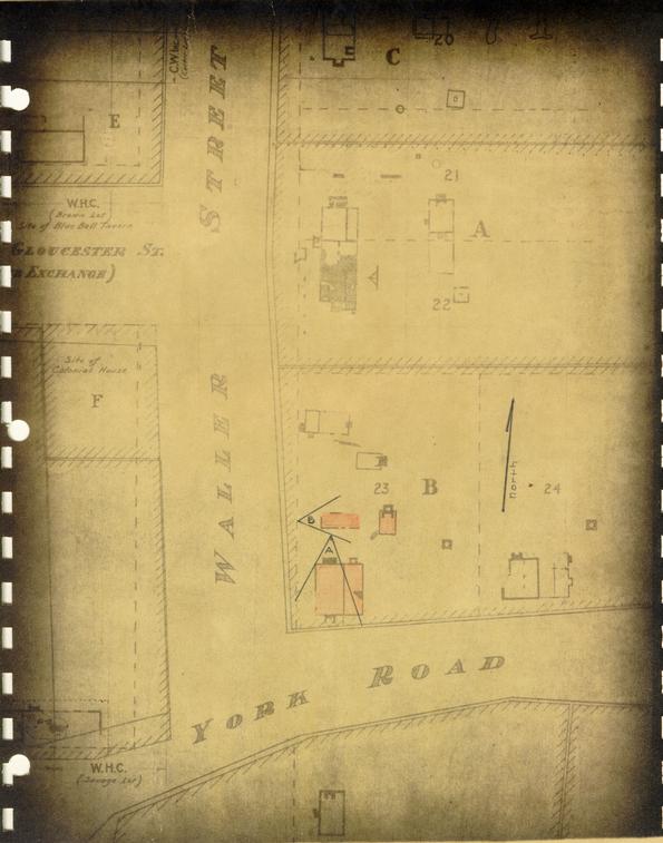 Plate IV
 Colonial Lot 23, Block 7
David Morton House and Outbuildings showing foundations uncovered by Archaeological excavations (poche'd in red)
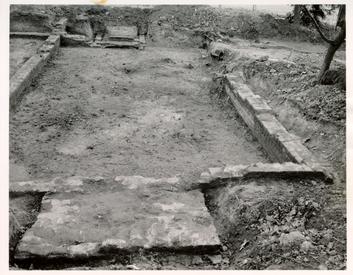 Original Foundations of Morton House, photo from A
 Original Foundations of Morton
 House Shop, photo from B
Footnotes
List of Drawings
David Morton House and Outbuildings - BLock 7
| DRWG. NO. | TITLE | SHEET |
|---|---|---|
| LP | LOCATION AND PLOT PLAN | 1 of 57 |
| U-1 | UTILITIES - BLOCK #7 | 2 of 57 |
| david morton house - bldg. # 15a | ||
| 1 | FOUNDATION & FLOOR PLANS | 4 of 57 |
| 2 | ELEVATIONS | 5 of 57 |
| 3 | FRAMING DIAGRAMS | 6 of 57 |
| 101 | SECTION - BATH ROOM ELEVATIONS | 7 of 57 |
| 102 | EAST CHIMNEY | 8 of 57 |
| 103 | NORTH CHIMNEY | 9 of 57 |
| 104 | BLKHD. PLAN, SECT. ELEV. & PANTRY | 10 of 57 |
| 105 | NORTH PORCH & ARE-AWAY PLAN SECTS. ELEV. | 11 of 57 |
| 106 | INT. STAIRS, PLANS & SECTS. | 12 of 57 |
| 107 | WEST PORCH PLAN ELEV. MISC. DETAILS | 13 of 57 |
| 108 | KITCHEN DETAILS | 14 of 57 |
| 201 | KNIFE PROFILES | 15 of 57 |
| 202 | WINDOWS #1, 2, & 3 | 16 of 57 |
| 203 | WINDOWS #4, 5, 7 & 8 | 17 of 57 |
| 204 | WINDOW #6 | 18 of 57 |
| 205 | DOORS #2 & 102 | 19 of 57 |
| 206 | NORTH PORCH DETAILS | 20 of 57 |
| 208 | DORMER DETAILS | 21 of 57 |
| 209 | WINDOWS # 101 THRU 106 & 207 | 23 of 57 |
| 210 | F. S. STAIR DETAILS | 24 of 57 |
| 211 | FIRST FLOOR STAIR DETAILS | 25 of 57 |
| 212 | EAST CORNICE & MISC. DETAILS | 26 of 57 |
| 213 &213-A | WEST CORNICE ~ MISC. DETAILS & CORNICE INTERSECTION | 27 & 28 of 57 |
| 214 | WEST PORCH DETAILS | 29 of 57 |
| 215 | MANTLE, DINING ROOM | 30 of 57 |
| 216 | MANTLE, LIVING ROOM | 31 of 57 |
| 217 | INTERIOR DOOR DETAILS & SCHEDULES | 32 of 57 |
| 218 | INTERIOR DOOR JAMB DETAILS | 33 of 57 |
| 219 | INTERIOR DOOR JAMB DETAILS | 34 of 57 |
| 220 | INTERIOR DOOR JAMB DETAILS | 35 of 57 |
| P-1 | PLUMBING PLANS | 36 of 57 |
| H-1 | HEATING PLANS | 37 of 57 |
| E-1 | ELECTRICAL PLANS | 38 of 57 |
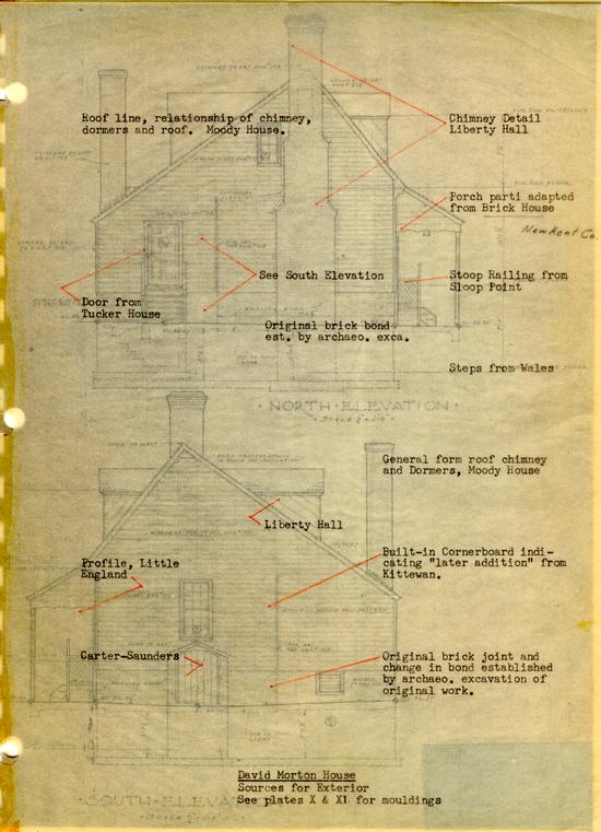
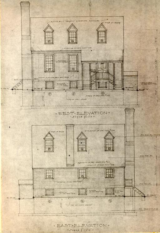 Plate VI
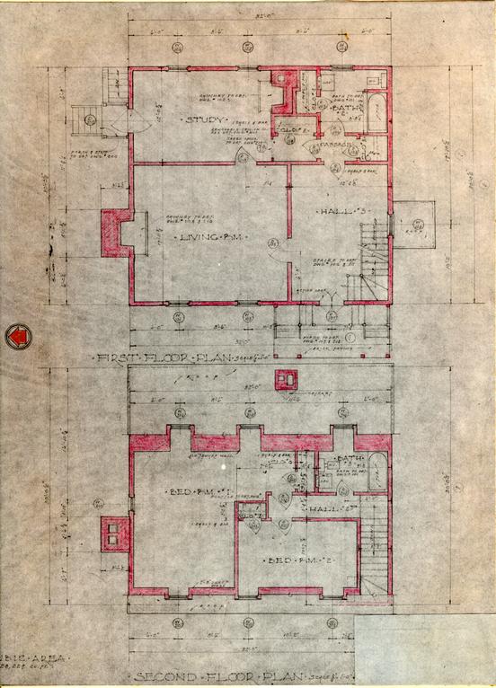 Second Floor Plan
MANTEL FROM
JAMES SEMPLE
HOUSE. DWG.#________
The original plan, deduced from the foundations, probably comprised the Hall and Living Room only. Two rooms, the Study and Bath-Passage area (two additional rooms) were later additions. The smaller, or south, room having a corner fireplace and being of the same dimension N & S as the Hall.
Facilities and uses are designed for use as a residence, not as a restoration.
The plan is very much like that of Liberty Hall.
The second floor is designed for use as a residence, not as a restoration. The original plan probably provided a Stair Hall and one room. The existence of dormer windows in 1785 is indicated by Humphrey Harwood's record of their "... lathing and plastering ..."
David Morton
Sources for Plan
Plate VIII
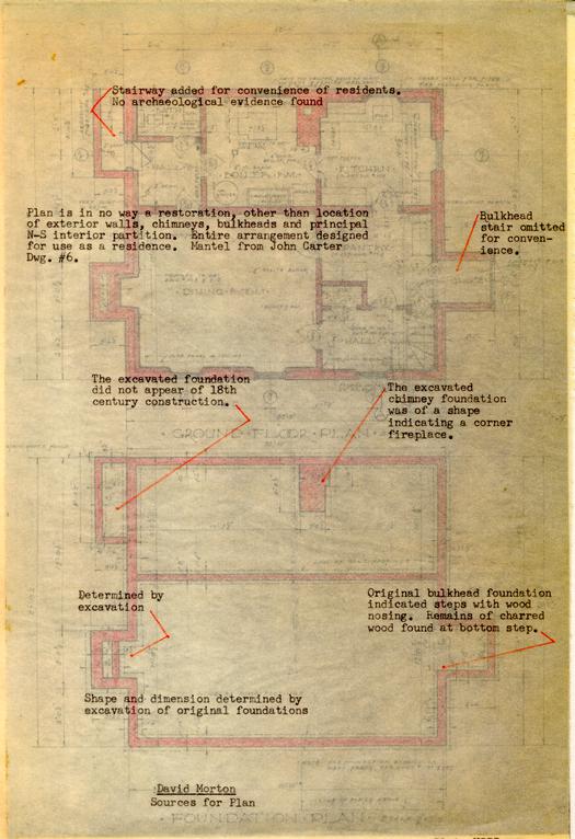 Plate VIII
The useable basement rooms were added for the convenience of residents, the original basement floor was earth 2'-6" to 2'-0" below the outside grade.
The elevation of the first floor at approximately 4'-6" above outside grade was established to provide sufficient head room for storage use in a basement excavated 2'-6" below outside grade.
The elevation of the second floor was established approximately 10'-0" above the first floor to achieve exterior proportions similar to those of Liberty Hall and the Moody House.
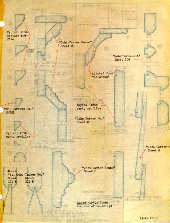
All interior trim was run to profiles similar or identical to 18th century examples, see plates X and XI for exact sources. Its use and location is as found in 18th century Williamsburg houses of this size.
The general design of the stairway is similar to that found at "Wales".
The exterior porch lighting fixture is a modern electrified reproduction of an 18th century lanthorn.
Kitchen equipment, baths, operation of basement windows, etc., are for convenience of residents.
David Morton House
Sources for Interior
See Plates X & XI for mouldings.
Plate IX
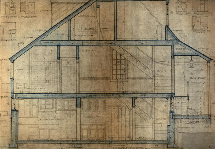 Plate IX
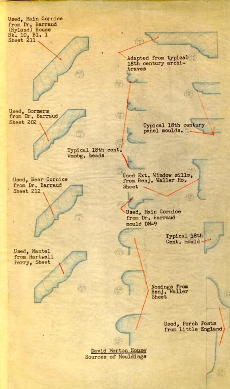 David Morton House
Sources of Mouldings
Plate X
 XI
XI
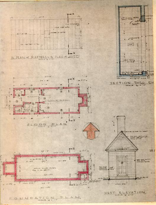
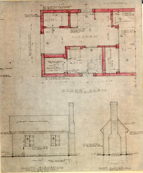
Historical and Archaeological evidence established the location and dimension of the building in plan. Its original use as a Kitchen was deduced from the size of the chimney foundations, which were found on the site, and the relation of the building to the main house.
An analysis of the foundations revealed that the inside chimney was of the same construction period as the principal foundation of the building, and that the outside chimney footings are of a later period. For this reason, an "inside" chimney plan was used in the design for the reconstruction, See Plate IV.
The thickness of the foundation walls indicate that the chimney end of the building was of brick and the remainder of the building was of wood frame.
The large exterior foundation is thought to have been built against the brick end of the building during the Revolution, at which time many forges were built in Williamsburg for the use of the armourers of the American Army. There is, however, no specified documentary evidence to prove this theory.
The location of the entrance door on the West side was established by traces of paving leading to the main house, which were uncovered by the archaeological excavation.
The general appearance of the building is not unlike that of many small outbuildings of 18th century Virginia, even though it is not a replica of any. The overall size is smaller than that of most of the kitchen buildings, and for that reason there is no development of the second floor. Similar outbuildings may be seen at the Carter-Moir and the Bracken Houses in Williamsburg; at Belleview, near West Point; at Whitemarsh, and at the Warrick County Poor Farm.
The interior is not a restoration. The floor is paved in brick pavers, reproducing 18th century examples, but the fireplace has not been replaced. The interior walls and ceiling are unfinished. The building is to be used for the private storage convenience of the tenants of the David Morton House.
The exterior trim, mouldings, etc., follow the same precedent as the main house, except that the wide cornerboards at the brick end were inspired by those used for a similar purpose on the Travis House. The english bond of the brick end was established by the remains found during the archaeological excavation.
David Morton House Kitchen
Sources
 XIII
XIII
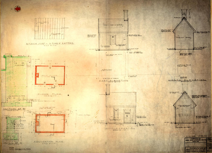
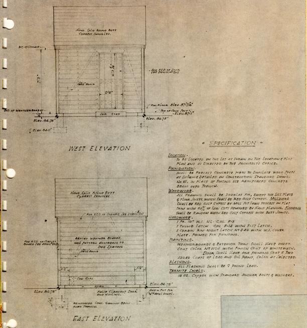
Historical and Archaeological evidence established the location and dimension in plan of this unusually small shop building, It is presumed from the Historical record that it was used variously as a residence and a shop and has been designed for reconstructeduse as a residence.
It was certainly but one story high because of its small and unusual dimension (9'-11¾" x 24'-9") and because the foundation walls found by archaeological excavation were but 8" wide and carried barely below the natural grade. The scanty foundation also indicated the probability of wood frame construction.
There were several examples of shops or tenements with their narrow dimensions and pedimented gable ends to the street in 18th century Williamsburg. Among those studied were, The Cole Shop, Blair's Apothecary Shop, The Coke-Garrett Office, and the Semple House. The Morton Shop is much smaller in scale than any of these examples but conforms to the parti.
The existence of a chimney at the rear or east end was confirmed by evidence of disturbed and undisturbed soil discovered by archaeological excavation. The chimney design is typical of the period.
All of the architectural details are in accordance with the same precedent sources outlined for the Morton House.
Morton House Shop
Sources
Plate XIII
 XIII A
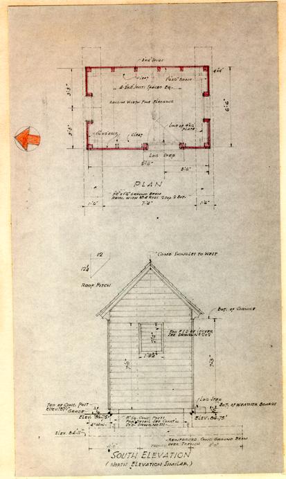 Plate XIV
The Necessary House is an entirely conjectural reconstruction since no documentary nor archaeological evidence of its existence has been found.
The 18th century privy at "Cumnor" and the restored privy at "Captain Orr's Dwelling" are close prototypes as is the original privy at the Archibald Blair House.
The structure is an exterior reconstruction only and conforms in architectural detail to the Morton House, and the above-named buildings.
Morton House Necessary House
Sources
Plate XIV
 XV
XV
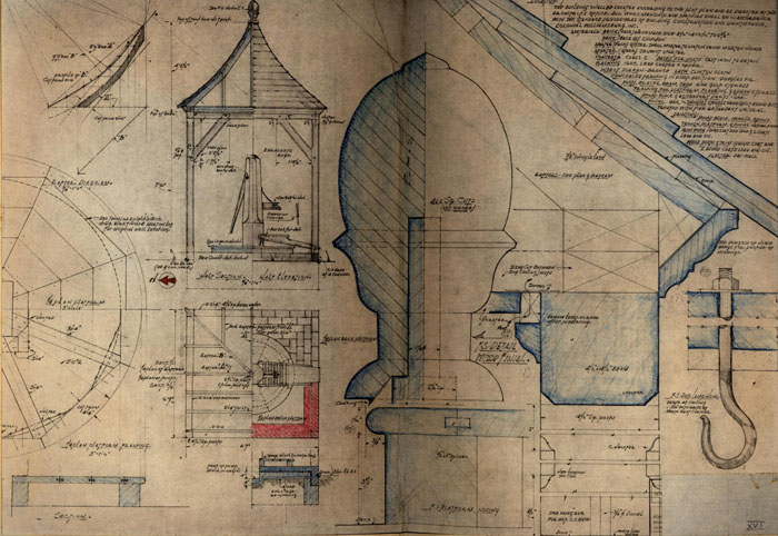
The size and location of the well was established by archaeological excavations.
The brick curb, wooden cover and pump were designed after a careful study of the Civil War Photographs (SPM) collection report plates 5, 12, 18; bits of iron found in excavations near old wells; pumps shown in 18th century illustrations such as "History of Sign Boards," Hotten.
The shelter was designed using the 18th century architectural vocabulary shown in the carpenters' handbooks of the 18th century such as The Builder's Companion, Wm. Pain. and details of mouldings, finials and chamfers and construction typical of the period in Williamsburg.
Authentic complete 18th century examples of such structures have failed to exist until the 20th century or to be recorded due to their vulnerability to deterioration.
The shingles are replicas, largely hand made, of 18th century split oak shingles.
Morton House Well House
Sources
Plate XVI
 XVI
XVI
 XVII
XVII
Archaeological excavations of the site failed to provide any evidence of the exact character or extent of the gardens and yards. It may be deduced that David Morton, a tailors, was relatively well off for documentary evidence reveals that he had slaves, and a description of his property reads "… all houses, palings, yards, gardens…"
This house, and adjacent houses, were designed for reconstruction as residences and the layout of the garden and yards took this use into consideration. The location of the Shop, Kitchen and Well were the determining factors in the basic design.
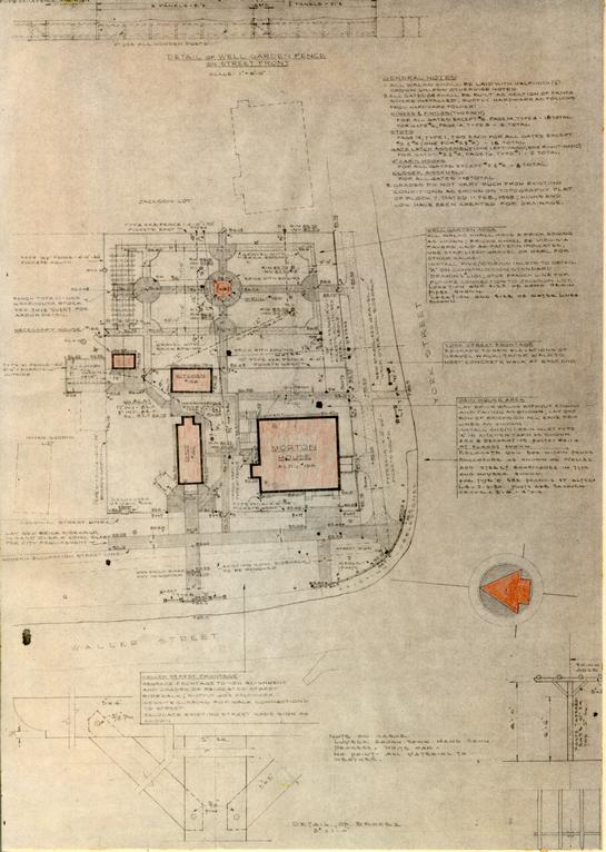
North and East Yard. A paved area has been provided to afford service and access between the House entrance to the lean-to, the Shop and the Kitchen. Walks from this area provide access to the other service facilities - laundry yard, necessary house, garden, and exits to York and Waller Streets. (The laundry yard is actually a part of the development of the adjacent lot and is discussed in the report covering that site.) The yards, paths and walks are to be planted with shade, decorative and fruit trees (as indicated on plate XVIII known to have been in Williamsburg in the 18th century. The surface treatment and edging of the walks (shown on plate XVII) is in accordance with the typical 18th century treatment, remains of which have been found in Williamsburg and on nearby sites of comparable character.
Waller and York Street Frontages The main house porch,
which was designed to reflectsuggest a semi-public character, in reflected
in the return of the fence and the wide paved
area
to the House. Similarly, a wide paved area will be found at
the entrance to the Shop. The fence line along Waller Street
was established by the remains of fence posts found by archaeological excavations.
Gardens. The basic design was adapted from
"Charleston,
South Carolina Plot Books of 1787" - "Mr. May's Garden on
Pinckney Street". The treatment of the parterres is similar
to those at the Bryan House (Bk. 14, Bl. 15A). The arbor,
simple in character and much as would have been constructed
in a relatively 18th century garden of hand sawn lumber
and skinned cypresslocust poles, terminates the garden along the north.
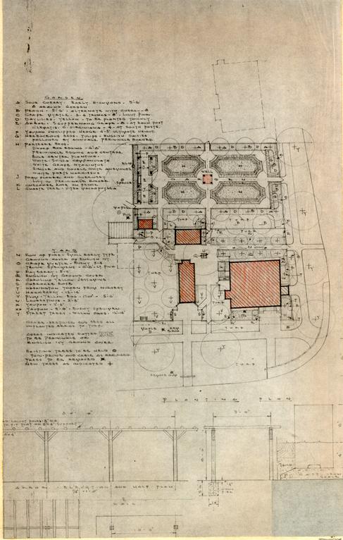
The planting (see plate XXVIII) has been carefully selected from
the materials in common use in the 18th century, to provide
the maximum immediate and long run effect with a minimum of
maintenance.
Fences. All fences are of a low picket type with gates
built as sections of the fences typical in design to 18th century examples found in
Williamsburg[illegible].
David Morton Landscape
Plate XVIII
INDEX TO DESIGN REFERENCE MATERIAL NOTED ON PLATES
| Belnemus - Powhatan County Virginia | Mid 18th Century | HABS |
| Blair, Archibald - CW | Early 18th Century | Bk. 29, Bl. 1 - Dwg.# |
| Brick House - Near Kino, Virginia | Early 19th Century | Photo EMF Collection |
| Blue Bell Tavern - CW Reconstruction | Early 18th Century | Bk. 8, Bl. 12A - Dwg. #201 Sh. 11 |
| Captain Orr's Dwelling - CW | Early 18th Century | Bk. 11, Bl. 11 - Dwg. # |
| Carter-Saunders House - CW | Early 18th Century | Bk. 30, Bl. 13 - Dwg. # |
| Carter-Moir House CW Reconstruction | Early 18th Century | Bk. 8, Bl. 29 - Dwg. #CM-201 Sh. 8 |
| Civil War Photos | SPM Collection and Report Plates 5, 12, 18 | |
| Cumnor - King and Queen County, Virginia | Photo EMF Collection | |
| Doctor Barraud's House - CW | Late 18th Century | Bk. 10, Bl. 1 - Dwg. #202, 211, 212 |
| Hartwell-Perry House - CW Reconstruction | Bk. 13, B1. 34D - Dwg. # | |
| History of (18th Century) Sign Boards, Hotten | p. 384 | |
| Little England - Gloucester County, Virginia | Third Quarter 18th | Photo Architectural Drafting Room Collection |
| Liberty Hall - Essex County, Virginia | Photo Architectural Drafting Room Collection | |
| Moody House - CW | Mid 18th Century | Bk. 2, Bl. |
| Robertson-Galt - CW | Early 18th Century | Bk. 9, Bl. 7 - Dwg. #208 |
| Semple, James - CW | Late 18th Century | Bk. 2, Bl. 7 |
| Sloop Point House - Pender North Carolina | P. 148 - Early Architecture of North Carolina, Johnston and Waterman | |
| St. George Tucker House - CW | Mid to Late 18th Century | Bk. 29, Bl. 2 - Dwg. #211B, 221B |
| 2 | ||
| Scotchtown - Hanover County, Virginia | Early 18th Century | HABS Collection Architecture Drafting Room |
| Toddsbury - Gloucester County Virginia | Early 18th Century | HABS Photos Architecture Drafting Room Collection |
| Wales - Dinwiddie County, Virginia | Early 18th Century | HABS Collection Architecture Drafting Room Dwg. #14 |
| Waller, Benjamin - CW | Early 18th Century | Bk. 1, Bl. 16 - Dwg. #M 2 |