King's Arms Tavern and Barber Shop
Archaeological Report, Block 9 Building 29A & B Lot 23Originally entitled: "Archaeological Report:
King's Arms Tavern and Barber Shop
Block 9 - Area B (2) & E - Colonial Lot 23"
Colonial Williamsburg Foundation Library Research Report Series - 1159
Colonial Williamsburg Foundation Library
Williamsburg, Virginia
1990
CONTENTS
Archaeological Report of H. S. Ragland: "Macon Lot and King's Arms Tavern", February 1, 1933.
Chronological Summary and General Description
- References to John Carter
- Insurance Policy 125
- Insurance Policy 667
- Archaeological Drawing Block 9, Area B, 12-10-32
- Archaeological Drawing Block 9, Area E (incomplete 9-15-41)
- Architectural Drawing: Comparative Study of Properties, Block 9, 2-3-41
Sources:
See Dwg. Block 9
Areas A & B
| TO: | H. R. Shurtleff, Director of Research & Record Department |
| FROM: | H. S. Ragland |
| SUBJECT: | ARCHAEOLOGICAL REPORT |
| FOUNDATIONS MACON LOT AND KING'S ARMS TAVERN. | |
| DATE: | Williamsburg, Virginia February 1, 1933 |
Submitted herewith are archaeological drawings showing the above mentioned foundations.
In the front part of the Macon lot (a part of Colonial Lot #24) at the site of the recently removed Macon House and the supposed site of the earlier King's Arms barber shop, no colonial foundations were found. In fact, nothing was found except a few fragments of interior walls of the Macon House which were not removed when the building was razed by Williamsburg Holding Corporation.
Several small foundations (old, but of undetermined date) built largely of bats laid in oyster shell mortar, were found in the rear part of the lot. Only a course or two exists in each wall, so no bond could be determined. A well was also found, but not excavated.
Between the site of the Macon House and the present Servient House a colonial foundation was uncovered, which apparently is the foundation of the King's Arms Tavern. The dimensions agree fairly closely with the measurements of that building recorded in the old Mutual Assurance Society fire insurance policies issued to Philip Moody in 1796 and 1806, and the site is the same - Colonial Lot #23.
Walls 1, 2, 3, and 4, built of "Palace" size bricks, laid in English bond, enclose the deepest cellar uncovered by excavation in Williamsburg to date. Remains of an arch springing from walls 1 and 3 show that the cellar had a barrel vaulted ceiling. (See plan, sections and elevations)
Section AA shows the layers of material excavated - about 2-½ feet -2- of earth fill, 1-½ feet of brick and plaster debris, and about 1 foot of ashes, covering fragments of brick paving. Below the paving a fill of clay, 4 feet deep, was excavated and below that about 2 feet of brick debris. The original undisturbed clay was found level with the bottoms of the walls about 11 feet below the surface.
As no ashes, plaster, or other material was found in the bottom layer of brick debris, it evidently is the remains of the fallen vaulted ceiling. Instead of rebuilding it the debris from it was left where it fell, two brick piers were built on it and a clay fill was made raising the basement floor to the elevation of the paving found about 5 feet below the surface.
Walls 5, 6, and 7 are evidently foundations of an addition to the original building, for the foundation is not bonded to wall 4 and the bricks are smaller (See sizes, bond, etc. on drawing.) However, this addition was evidently built prior to 1796, for the foundation not only looks very old but it is necessary to add its dimensions to those of the original foundation to even approximately check the measurements of the front portion of the building, recorded in the insurance policy dated that year. The basement floor of this addition, laid about one course above the bottom of the foundation walls, was about a foot higher than the brick paving found in the eastern basement above the clay fill. Both of these floors were covered with ashes, about 1 foot deep, clearly indicating that the whole building was destroyed by fire. In the eastern end of the foundations above the ashes a large piece of the fallen east wall was found. Its height, when added to the existing east wall, extends about 7 feet above grade, and about 3 feet above the probable first floor level of the building. All of this is good evidence that the building was brick. Certainly, the east wall must have been. The fallen wall also shows that there was no chimney in the east wall and that the bricks in the superstructure were Palace size, laid in English bond with -3 - oyster shell mortar.
Entrance to the deep vaulted collar was evidently through the west end wall under the arch, probably originally from the outside of the building, and later, when the western addition was built, from the western cellar. The toothing in the east side of wall No. 4, below the entrance, is apparently an indication that steps from the floor of the eastern cellar leading to the entrance to the western basement were anchored there. Putlog holes also were found in both the eastern and western walls of the eastern cellar. (See Elevations)
That the arc of the vaulted ceiling was semicircular was indicated by the dotted line on Section B-B and the center for striking it was at Elevation 78, 64 (below the apparent spring line) was determined by trial in the field using a radius of half the width of the cellar, and raising and lowering the center and striking the arc, until one was struck that coincided with the fragments of the arch which still exists. Apparently the builder in constructing the arch built up his side walls plumb about a foot higher than he intended and did not remove those portions because when he set his arch centers those portions of plumb walls above his spring line were so slightly off the curve of the arch that it was not noticeable.
A three centered or elliptical arch was not used, for one constructed to fit the fragments of arch still existing would not have provided head room for entrance into the cellar from the western basement, where the opening shows it was.
At No. 9 on the drawing, remains of brick steps to an areaway (indicated by ashes and filled ground) and entrance to the western basement through the south wall of the building were found. (See plan and section).
As the 4" walls, Nos. 11 and 12, are not bonded to walls Nos. 1 - 4 - and 3, and are built of smaller bricks, they were evidently added later, perhaps to support joists, the ends of which had begun to rot in the original walls. Wall No. 10 is not bonded to the original foundation, is built of smaller bricks, the size of those in the western cellar foundation, and is probably contemporary with it.
The modern house, removed by the Williamsburg Holding Corporation, was built over the western basement. A part of its front foundation wall was not removed when the house was pulled down, and is shown north of wall No. 7 (See plan).
The small foundation of outbuilding, found about 40 feet south of the western end of the main foundation, is an extremely poor one, built almost entirely of brick bats with no mortar. It is probably modern, although its dimensions are roughly those of the typical Williamsburg colonial dairy or smoke house foundation. An old well was found near it, built with bricks of modern size laid in shall mortar.
It is recorded in the insurance policies, previously referred to, that there was a wing (34' x 57') added to the main building. No foundations of such a wing were found. The sketches (in the two policies) of this wing are conflicting - one showing the wing extending toward the south from the western end of the building, the other from the eastern end of the building. I do not think that the existence of the well and small foundation found south of the western end of the main foundation is conclusive evidence that the wing was not added to the western end of the main building, as both well and small foundation may be modern. South of the eastern end of the main foundation numerous trenches were cut, but not only were no foundations found, no indications were seen that the ground had ever been disturbed below the top soil. Even that, about a foot deep, seemed original and was unmixed with clay.
- 5 -All debris, excavated in uncovering the King's Arms foundations, was screened. All objects found, were turned over to R. Goodwin.
Herbert S. Ragland
REFERENCES TO JOHN CARTER, SELECTED FROM FILES OF THE DEPARTMENT OF RESEARCH AND RECORD
| April 18, 1745 | John Carter near the Capitol has a license to retail liquor. Offers cheap entertainment; also good lodging. (Virginia Gazette. - Card 123) |
| October 10, 1755 | John Carter, intending for Great Britain, calls on his creditors to pay. (Virginia Gazette, - Card 410) |
| June, 1760 | John Carter's lot is declared by Joanna McKenzie to be west of her lot which apparently is #24. (York County Records - Card 628) |
| August 15, 1765 | James (Surgeon) and Hester Carter grant to brother, John Carter, part of lot #53. On the west is the brick house built by John and James Carter and is now in their possession. (Ibid. - Card 690) |
| February 25, 1768 | List of goods for sale at John Carter's store; dry goods, etc. (Virginia Gazette - Card 631) |
| February 23, 1769 | John Carter in the Virginia Gazette says he will leave for England very soon. Would like to get rid of the goods in his store. His shop near Mr. Charlton's is to be rented. (Mr. Charlton's is Block 9, Lot #22) (Ibid. - Card 865) |
| May 4, 1769 | B. Grymes calls on creditors to meet him at John Carter's, next door to Mr. Ayscough's. (Ibid. - Card 905) |
| April 5, 1770 | John Carter's store has been robbed. This store is in the most publick part of the Main Street. (Ibid. - Card 1045-A) |
| April 19, 1770 | John Carter is going to England. Has books for sale. John Ferguson will keep the store during his absence. (Ibid. - Card 1052) |
| November 29, 1770 | Cloths, luxury foods, munitions, books for sale at John Carter's. No wines. (Ibid. - Card 1145) |
| October 17, 1771 | In advertising this house, John Carter speaks of self as merchant. (Ibid. - Card 1276) |
| February 6, 1772 | Mrs. Vobe announces herself at the Sign of the King's Arms,* a house lately occupied by John Carter. (Ibid. - Cad 1415) |
| January 7, 1773 | John Carter advertises all sorts of garden seeds at his store. (Virginia Gazette - Card 1458) |
| November 11, 1773 | Cloth, shoes, wares, luxuries such as candies and spices for sale at John Carter's. (Ibid. - Card 1656) |
| - 2 - | |
| February 2, 1775 | Women's, girls and children stays can be bought at John Carter's. (Ibid. - Card 1881) |
| December 13, 1776 | John Logan asks journeymen tailors to meet him at John Carter's, south side of the Capitol. (Ibid. - Card 2440) |
| November 21, 1777 | John Carter now lives at the brick building next to the Raleigh. (this is on lot #53) (Ibid. - Card 2665) |
| July 19, 1779 | William Carter's shop on lot #53 is bound on the east by John Carter, merchant. (York County Records - Card 795) |
| March 29, 1783 | John Carter advertises his brick house with a store and counting room below. It adjoins the Raleigh. (Virginia Gazette - Card 2995) |
| February 24, 1792 | John Carter dwells at brick store house adjoining the Raleigh, very convenient for a family. (Virginia Gazette - Card 3182) |
CHRONOLOGICAL SUMMARY
At an unknown date (probably not before 1707 and certainly not later than 17443), Byrd acquired lot 23.
| February 26, 1749 | The "storehouse" mentioned in the Crosby-Buchanan deed was on the "middle lot" -presumably lot 23. This may have been the barber shop of which the foundations have been found in Area E. |
| Lot 21("Richard Bland") | Wetherburn's Ordinary |
| Lot 22 | Wetherburn's Stable and Warehouse4 |
| Lot 23 | "King's Arms" Barber Shop then perhaps a store |
| Lot 24 | Small house of 1707 |
| July 3, 1752 | John Hyndman5 advertised for sale "Houses and Lots"6 opposite Raleigh Tavern. |
| June, 1760 | The deed of trust indicates7 that the owner of lot 23 was John Carter. |
| - 4 - | |
| February 23, 1769 | Advertisement of John Carter which mentions "store" and also "the shop" - suggesting hat two buildings may have existed by this time, the newer one used not as a tavern as a store. |
| 1770-76 | Charlton and Charlton-Nichols Wig-making and Barbers business may have been carried on in the King's Arms Shop, for Charlton's Ordinary stood next door, on lot 22.8 |
| February 6, 1772 | Jane Vobe opens tavern at the "Sign of the King's Arms ... House lately occupied by Mr. John Carter". |
| 1777-85 | Humphrey Harwood, in account with Jane Vobe, mentions 14 rooms, 4 passages, bar, 2 porches, front porch, outbuildings, etc. |
| November 21, 1777 | John Carter lives on lot 53. The removal may be assumed to have taken place in 1772. |
| C. 1785 | Jane Vobe dies. |
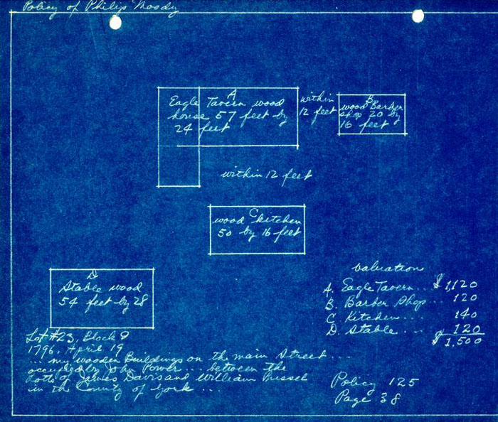
| April 19, 1796 | Insurance plat of Philip Moody for lot 239, showing: "Eagle Tavern"10 57 x 24, and rear wing; Barber Shop and outbuildings. |
| C. 1800 | Unknown Draftsman shows lots 23 and 24 owned by (Philip) Moody. |
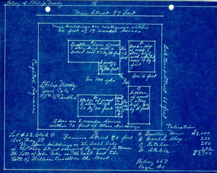
| March 27, 1806 | Insurance plat of Philip Moody, showing: Dwelling, 57 x 24; wing 57 x 34; Dutch roof, Outbuildings as in 1796. (Building later destroyed by fire.) |
EXCAVATION
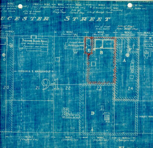
Areas A and B have the same north end boundaries, and almost the same lateral boundaries, as the northern portions of Colonial lots 23 and 24. The methods followed in the first excavation of these areas are described in the attached Ragland report.
Area E
Certain inconsistencies in the insurance plats and other evidence (see below, Barber Shop) aroused the suspicion that the barber shop might have stood near the northwest corner of lot 23 rather than the northeast corner as the insurance plat indicated. A number of trees growing here had made thorough investigation difficult at the time of the first archaeological work. The trees were now moved, and this corner now called Area E was explored a second time.
Area F
It was also felt that results of exploration in the north portion of lot 24 (Area A) had been unsatisfactory, partly because the traces uncovered did not seem to be in accord with historical evidence; and partly because two, small outcrops of foundation in the northeast corner noted on early landscape surveys, had never been further explored. (Possibly a tree stood in the way here also, or excavation may have been restricted in the interests of economy.) Digging was again undertaken in the front of this lot, which was designated Area F.
Early foundations were eventual1y.uncovered in both Area E (See Barber Shop) and Area F (see Purdie's Dwelling)
Lot 23 - King's Arms
The Barber Shop (Photos N-6590, 6671-2-3)
This building can be traced back to 1749, when it was mentioned in the Crosby-Buchanan deed as a "storehouse". The earliest mention of a barber shop is that of 1768. A likely theory seems to be that John Carter, -7- in 1752 (when Hyndman advertised the lot for sale) or soon after, bought the lot and small store, and that before 1768 (perhaps soon after 1752) he built a larger store and rented the smaller one as a barber shop. The latter continued in this use until at least 1806.
The insurance plats show the barber shop 12' east of the tavern, and excavations were carried out in that direction with indecisive results. A small foundation was indeed discovered, but at a distance of 45' from the tavern, and larger than the building shown on the plats (16' wide and 19 or 20' long).
The rear wing of the tavern was shown on the west side on the plat of 1796, and on the east side on the plat of 1806. It was argued from this discrepancy that confusion might also be present in other east-west relationships. The Frenchman's map, showing a small building in the space between the King's Arms and the Servient house, was further evidence to the same effect. Possibly the barber shop had actually stood westward of the tavern. More digging was undertaken, and this somewhat audacious theory was vindicated with the discovery, just 12' west of the tavern, of a foundation precisely 16 x 20' in size.
The street front is the short side.
The walls have been considerably altered from time to time. At present they are 9" at the sides and 13" at front and rear, enclosing an unpaved basement 5' deep. At the southwest corner, an earth bank extends into the basement and the foundation is at grade level. The rear wall, of late (though perhaps colonial) brickwork, has an opening near center and another on the west. Both are on the high level. Flanking the west opening are 4" and 13' wing walls of early brickwork.
The west wall is of later brickwork and has an opening near the south end. Inside this opening and to the north of it (in the deep basement) is a block of early brickwork which may indicate a pier. It seems just possible - 8 - that this may be a fragment of a chimney, or that a chimney may have stood on the high level near the southwest corner.
The east wall consists of early brickwork at the ends and center and later work between, as if openings between early piers had been filled in.
The front (north) wall is of late 9" work at the west end and early 13' work at the center. At the east end are clear traces (photograph N-6590) of a bulkhead stair leading from the street to the basement. These were the usual brick steps with wood nosings. The cheeks seem to have been farther apart when first built, and to have been thickened at a later period by four inches of brickwork on the inside.
The great variety of brickwork in these foundations is puzzling. One possible interpretation is that the barber shop was the second building on this site, replacing an earlier building on 13' walls or piers which might have stretched westward under the present Servient house. The 9" portions of the foundation would then belong to the second period, when the barber shop was built. Unfortunately this theory cannot be tested, for the Servient house stands in the way of investigation and its foundations may have destroyed any evidence that may have existed.
The evidence of the existing foundations is inconclusive on several important points: Where did the chimney of the barber shop stand? Where were the basement window openings, if any? etc.
The Frenchman's map indicates that at the time it was drawn (1786?) there may have been a connection of some kind between the barber shop and the tavern.
From the insurance plats it was learned that the shop had a "Dutch roof."
| Brick | 8-½" x 4" x2-½" |
| 9-¼" x 4-½ x 2-½" | |
| Bond | - English |
| Mortar | - Shell |
| Condition | - Fair |
The Tavern
The date seems to be after 1749, because only one "storehouse" is mentioned as standing on lot 23 in the deed of that year, and that is probably the building which was later the barber shop17. John Carter may have bought the lot as early as 175218. But there is no evidence to show how soon he built the larger house, for he could have lived and traded in the "storehouse" for some time19. At any rate, it is highly probable that both buildings were standing by 1769, when an advertisement20 mentions both a -10- store and a shop. It seems reasonable to suppose that John Carters having constructed the larger building, moved his store into it and rented the smaller building as a barber shop. It seems likely that the barber shop of Geoghagan and Brazier21, opened in 1768, was in this location. This year then may be taken as a probable posterior limit for the construction of the building which was to become the tavern, or at least of its earlier portion.22
The main portion was clearly built at two periods, the eastern portion first.23 The rear wing may have been built at still a third period. But the entire front and the rear wing must have been completed by 1796, Since they appear on the insurance plat of that year. It may be surmised Further that both the west front portion and the rear wing were built before 1779, the year of the removal of the seat of government. Strong evidence in support of this supposition is Humphrey Harwood's account with Jane Vobe, beginning in 1777. In this year is mentioned the whitewashing of 14 rooms; in 1778, 12 rooms, 3 passages, and front porch; in 1779, shop; in 1780, 14 rooms and 4 passages; etc.
To sum up, the most likely theory seems to be that the east front portion was built not long before 1768, and the west front portion and rear wing between 1772 and 1777.24
-11-The purpose and history of the great brick vault25 under the east or early portion of the building must be a matter of conjecture. If the foregoing reasoning is valid it was built as part of a store, rather than a tavern. A vault of this sort was almost certainly intended for the storage of wines and liquors. Yet no mention of such wares is to be found in any of the advertisements of John Carter at this location.
The foundations of the front portion of the tavern measure 54 feet in length, but the insurance plats show a building 57 feet long. (The width checks at 24 feet.)
At the southwest corner of the foundation there was a stair bulkhead which may have projected three feet. If this bulkhead was included in the overall the actual length would check with the dimension of the insurance plat.
There is some evidence26 that an outside chimney stood at grade level at the east end; perhaps with the outside frame closets that were so common in such cases. Such a construction could also have brought the overall length to 57 feet.
-12-Further evidence that this chimney and closet (or closets) existed is considered below under "Purdie's Dwelling" (p. )
In the insurance plat of 1806, dimensions of 57 by 34 feet are given for the rear wing. In the absence of any archaeological traces, these dimensions are of dubious value. (The wing itself is shown on different sides of the building on this plat and on that of 1796.) The length of 57 feet might include the wing alone, or the overall of the wing, plus the front portion, perhaps even including one or more porches. The latter possibilities seem the more nearly in accord with common practice in drawing up these plats, and also with the scale - such as it is - of the two plats in question.
Similarly, the width of 34 feet might be that of the wing itself, or of the wing and a porch or lean-to, more likely the latter, as a wing wider than the main building would present an awkward problem in roof plan, especially with the gambrel construction which is indicated on the plat.27
The foundations of the tavern are unusually thick (18" or 19") for a wood building. Yet the insurance plats clearly state that it was of wood. The reason for their thickness was probably the great depth of the cellar.
Outbuildings (See Photograph N6672)
Thirty to forty feet south of the southwest corner of the tavern foundation were found traces of a late well and outbuilding (See Ragland Report, p.4).
Immediately west of the outbuilding were several areas of earlier brickwork, of which one had the shape of a kitchen or laundry chimney, -13- and another seemed to be a trace of floor or hearth paving of a kitchen of a different - probably earlier - period. Apparently related to this earlier kitchen was a pit four feet square, more than a foot deep, and walled and floored with brick. It is possible that this pit served as a cooling basin, perhaps an interior cistern. Two stretches of brick laid in the pattern of drains radiate from it to south and east.
| Brick | - 8-½" x 4" x 2-½" |
| Mortar | - Shell |
| Condition | - Fair |
According to insurance plats, two large outbuildings existed at a late period behind the tavern., The kitchen was given in 1796 as 50 x 16 feet, and ten years later as 30 x 16 feet. This kitchen is shown with its long dimension east and west, whereas the archaeological evidence suggests that the second kitchen, at least, ran north and south. This evidence, however, is scanty and inconclusive.
The stable seems to have been 52 or 54 feet long, and 20 feet wide with an 8 foot lean-to shed. No traces of this stable were found. Its great size suggests that it may have been in sue during the time of the King's Arms Tavern. The distance of 100 yards is shown on the plat between the tavern and the stable. This is manifestly a mistake, for at 100 yards the stable would be beyond Francis Street. Probably 100 feet is intended.
The Frenchman's map shows two outbuildings behind the barber shop, one of which from its size might be a kitchen, the other a smokehouse or dairy. From the supposed kitchen an alley seems to run south to Francis Street. A fence is shown crossing the lot about halfway between "Sud" (Francis) Street and the Duke of Gloucester Street.
Many if not all the buildings on the Frenchman's map were located by pin pricks before being drawn in. Close study of the map, under magnification where necessary, reveals such pricks still visible near the corners -14- of most buildings. In a few cases buildings were pricked out but for some reason never drawn in. It is certain that the reason for the omission was not that the buildings did not exist, for sometimes foundations corresponding to the pin pricks have been found.
Behind the King's Arms two sets of pin pricks can be made out on the Frenchman's map, in addition to the buildings which are drawn in. Apparently they represent a medium sized outbuilding north of the half-way fence, and a large one south of the fence. Both run east and west. No foundations were found in these areas, but it was clear that early brickwork had been scattered and destroyed by plowing by the landscape department. It is assumed that these indications on the map represent a laundry on the north and a stable on the south. Humphrey Harwood's accounts mention a kitchen and a laundry.
Footnotes
Further evidence to the same effect is the fact that Wetherburn's Ordinary is believed to have been built on lot 21 in 1739 or earlier, so that lot 22 next door would be a likely site for a stable and warehouse.
See York County Records:
Deeds, Book IV, p. 20
Wills, Book XVIII, p. 589
As the history of lots 23 and 24 came by degrees to light, previously held opinions as to the history of these lots had to be drastically revised in several instances11, noteworthy among which are the following:
The first records of the King's Arms to be studied indicated that it stood on Colonial lot 2424. But by 1932 the Department of Research and Record was able to state13 that the King's Arms stood on lot 23, and this view was confirmed by the Archaeological Report of 193314.
Uncertainty existed until recently as to the location of the King's Arms Barber Shop. Area F, Block 9 (east of the King's Arms, in the northeast corner of lot 24) was thought to be the likeliest site, for two reasons:
- 1.Foundations in Area F seemed to be those of a small building, such as a barber shop might be expected to occupy.
- 2.Insurance plats of 1796 and 18O615 showed the barber shop east of the King's Arms Tavern.
It was supposed until recently that Purdie's Dwelling had stood on lot 25, the site of the present Tilledge house. But at present the historical evidence appears conclusive that Purdie's Dwelling stood on lot 24 - part of it, probably, on Area F. The small foundations in that area, clearly not those of the whole of Purdie's Dwelling, might have supported an earlier structure.16
But no traces of Purdie's Dwelling have been identified. This then is a case where historical evidence has been accepted to the exclusion of archaeological evidence (which, if accepted uncritically, would indicate no early construction in lot 24 beyond the small early foundation of Area F).
- a.No notices have been found of a tavern on lot 23 before Mrs. Vobe, but may notices have been found of general trading. It appears improbable not only that a tavern would have been conducted without any printed evidence, but also that a tavern and a store should both have been conducted in the same building by the same man.
- b.A John Carter, appears in the Virginia Gazette of May 4, 1769 as next door to Mr. Ayscough's (Block 8, Area A). Possibly his house was on the foundation discovered in Block 8 Area B. He is mentioned again on December 13, 1776, as living on the south side of the Capitol. It seems probable that this is the John Carter of the advertisement of 1745, but that the John Carter of lot 23 was another individual. (Carter was one of the commonest names of the Tidewater).
At the southeast corner of the main foundation is a short outside wing wall which might possibly have been part of the foundation which carried an outside closet.