George Reid House (LT) Archaeological Report, Block 11 Building 11 Lot 15Originally entitled: "The George Reid House Site
(Colonial Lot 15, Block 11, Archaeological Area E)"
Colonial Williamsburg Foundation Library Research Report Series - 1240
Colonial Williamsburg Foundation Library
Williamsburg, Virginia
1990
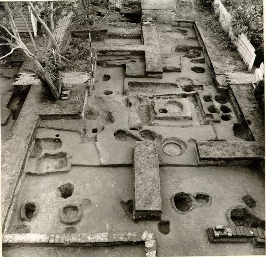 Fig. 1. The Reid garden after excavation, with foundation of colonial kitchen in foreground. Photo from the west. 63-GR-651-10
THE GEORGE REID HOUSE SITE
(Colonial Lot 15, Block 11, Archaeological Area E)REPORT ON ARCHAEOLOGICAL EXCAVATIONS
FEBRUARY TO OCTOBER, 1963
PARTS I AND II
REPORT ON ARCHAEOLOGICAL EXCAVATIONS FEBRUARY
TO OCTOBER, 1963
PART I
THE EXCAVATIONS
CONTENTS
Part I
| Table of Illustrations | iii |
| Introduction and Summary | 1 |
| Precis of the Site History | 4 |
| Detail of the Frenchman's Map | 11 |
| The Archaeological Evidence | |
| The George Reid House or "Barlow House" | 11 |
| The Colonial House | 12 |
| The Store | 15 |
| The Carriage House | 21 |
| The Eighteenth-century Kitchen | 22 |
| The Smokehouse | 26 |
| The Dairy | 28 |
| The Well | 29 |
| Timber (?) Structure east of Kitchen | 30 |
| Walkways | 31 |
| Fencelines | 33 |
| The Lumber Yard | 36 |
| The Dog Burial | 37 |
| The Excavation Photographs | Following 39 |
| The Excavated Artifacts | 40 |
| Ceramics (Fig. 32 - 34) | 42 |
| ii | |
| Table and Pharmaceutical glass (Fig. 35) | 53 |
| Beverage bottles (Fig. 36) | 56 |
| Small finds (Fig. 37) | 57 |
| Iron objects and small finds (Fig. 38) | 64 |
| Tobacco pipes (Fig. 39) | Following 67 |
| Appendix I. Table of Brick Sizes | 68 |
| II. Clay Tobacco Pipe Dating in the Light of Recent Excavations | 69 |
| III. Appraisement of Hugh Orr's Estate | 75 |
| IV. Ms Ledger B of Humphrey Harwood | 77 |
| V. Insurance Plats, 1814, 1823, 1830, 1839, 1846, 1853 | 79 |
| VI.A Dating of Excavation Register Groups | 85 |
| VI.B Summary of Excavation Register Numbers | 105 |
| VII. Key to Figures 2 - 6 | 118 |
| VIII. Photographic Negative Numbers | 119 |
TABLE OF ILLUSTRATIONS
Part I
| Figure 1 The Reid garden after excavation with foundation of colonial kitchen in foreground. | Frontispiece |
| 2 Plan of robber trenches of Captain Orr's Dwelling, walkways, drains, and dairy foundations. | 12 |
| 3 Plan of surviving remains of store foundations. | 15 |
| 4 Plan of remains of carriage house foundations. | 22 |
| 5 Plan of colonial kitchen showing early and late extensions, the former sealed beneath the smokehouse. | 23 |
| 6 Plan of walkways, successive well heads, fragmentary dairy (?) foundation, and unidentified timber structure. | 29 |
| 7 Plan of excavated area showing relationships of Figures 2 - 6. | 39 |
| 8 Plan of entire Reid site. | at rear |
| Figure 9 | Robbed south wall of Orr House as exposed south and west of existing structure. |
| 10 | Detail of robbed south wall of Orr dwelling showing impressions of its bricks in the clay trench bottom. |
| iv | |
| Figure 11 | Detail of robbed south wall of Orr dwelling showing surviving bricks in situ. |
| 12 | Detail of robbed east wall of Orr house exposed beneath passage between existing house and kitchen. |
| 13 | Part of bed of tobacco pipe and glass fragments used in paving, contemporary with Captain Orr's Dwelling, and partially destroyed when the house was dismantled. |
| 14 | Remains of store south foundation. |
| 15 | Deposit of broken bottles, c.1800, on south wall line of store. |
| 16 | Robbed southeast corner of store indicated by string lines. |
| 17 | Remains of small chimney (?) foundation inside store. |
| 18 | Foundation of carriage house in course of excavation. |
| 19 | Remains of east foundation of carriage house cut through by later post holes. |
| 20 | Foundations of eighteenth-century kitchen with interior chimney, and remains of hearth. |
| 21 | South extension to kitchen showing southeast corner. |
| 22 | Interior of exposed smoke-house after excavation. |
| 23 | Remains of north wall and northwest corner of possible colonial dairy. |
| 24 | Detail of well head. |
| v | |
| Figure 25 | Shallow trench filled with shells and brickbats, possibly for drainage, against east wall of unidentified timber structure. |
| 26 | Impression of timber structure after excavation. |
| 27 | Shallow pit, with iron barrel hoop at bottom immediately west of unidentified timber structure. |
| 28 | Brick walk leading to well. |
| 29 | Walkway to kitchen showing early brick drain cut through by later drainage channel. |
| 30 | Shallow trenches south of the Orr well, probably impressions of sleeper timbers layed down when the property was occupied by a cabinet maker. |
| 31 | Skull of Miss Emma Lou Barlow's dog, "Toby", which was buried in the garden c.1881. |
Introduction and Summary
Following the death in 1962 of Miss Emma Lou Barlow, the life tenant of The George Reid House, Colonial Williamsburg began to explore the possibility of turning the house into an exhibition building, and reconstructing Hugh Orr's blacksmith shop which was believed to have stood on the southwest corner of Duke of Gloucester Street and Colonial Street. It is hard to determine how this belief became (see pp. 4-5) established as the only available documentation refers to a "store house" and to a "Cabinet makers shop." Nevertheless, the initial decision to excavate was prompted by a desire to find a blacksmith's shop on the corner immediately east of the existing house. The site had received some archaeological attention in 1928 when the house (then known as the Barlow House) was first acquired by Colonial Williamsburg, at which time the foundations of a kitchen building were located, as also were various short sections of brick paths and drains. Because none of these features had been incorporated into the early restoration and landscaping, it was deemed advisable to undertake a minimal re-excavation of the garden area immediately south of the house to accurately locate the foundations and walks, and also to try to obtain dating evidence for them.
As soon as digging began, it became apparent that the archaeological remains were much more prolific than the 2 drawings made in 1928 led one to believe. Consequently, the project was greatly enlarged to comprise the complete excavation of the garden in the immediate vicinity of the house, as well as the cross-trenching of the orchard and stable areas.
Although slight traces of a rectangular building were found at the northeast corner of the lot, there was insufficient evidence to associate these with a blacksmith's shop. The resulting plan (Fig. 3) was, however, consistent with the requirements for an eighteenth-century store. To the south of these remains was encountered the mutilated foundation of a building which appeared on an 1814 insurance plate as a "Carriage house" (Fig. 4). The kitchen at the opposite side of the site (Fig. 5) was re-excavated and found to have possessed a northerly lean-to extension whose foundations lay partially beneath the existing smokehouse. That extension has been dismantled when the smokehouse was built and had been replaced by another at the south end of the kitchen. A dairy foundation (Fig. 2) was found beneath the floor of the present (modern) kitchen, and this had probably been moved from an earlier location immediately to the west of the well where comparable foundations were encountered. The position of the well (Fig. 6) had been changed in the late eighteenth century, the head being turned slightly so that it stood parallel to the other outbuildings.
It was evident that a great many changes and improvements were made to the property in the closing years of the eighteenth century. The most dramatic of all is believed 3 to have been the total dismantling of Captain Orr's Dwelling and the building of a new house on an entirely different plan. This is the house which stands on the site today.
Considerable evidence of iron and brass working was found to the rear of the present house, most of it being concentrated toward the western extremity of the property. In addition, a well-defined foundation trench enclosing an area measuring approximately 4'10" x 3'6" was found east of the colonial kitchen (Fig. 6). There was no doubt that this dated from the Orr period, though its purpose was not immediately apparent.
Artifacts from the Orr site were plentiful, and though informative, very few are likely to be of value as museum specimens. This was occasioned largely by the fact that only two small rubbish deposits were found, the vast majority of the objects being derived from a multitude of extremely small fragments scattered through most of the soil strata around the house. A few small objects are notable, among them a gold finger ring, (Fig. 37, No. 9) a silver toilet instrument, (Fig. 37, No. 4) a sleeve-button ornamented with a portrait of Queen Anne (Fig. 37, No. 7) various buttons, the first colored enamel-twist wine glass stem found in Williamsburg (Fig. 35, No. 1) as well as the first examples of late seventeenth-century Bideford sgraffito slipware (Fig. 34, Nos. 5-6) to be recovered from the city.
Precis of the Site History1
Nothing is known of Lot 15 during the first quarter of the eighteenth century, though the presence of unusually early artifacts on the property suggests that it was occupied in that period and perhaps as early as the last days of Middle Plantation. The first firm documentary evidence is a mortgage from Hugh Orr dated July 8, 1743, wherein it was stated that Edward Barradall had been the previous owner of the property. Barradall had immigrated to Virginia in about 1730, and had moved to Williamsburg by 1736, in which year he became mayor of the city. The following year, he was elected Attorney General of the Colony, and in 1738, he became a member of the House of Burgesses representing the College of William and Mary. In the absence of evidence to the contrary, it may be supposed that Barradall lived on Lot 15 during these years. In 1742 he received one last honor, being appointed Judge of the Court of Vice-Admiralty. By June of the next year he was dead, at the early age of thirty-nine. His wife died in the following October, and both are interred together in Bruton Parish churchyard.
There is reason to doubt whether Baradall was living on Lot 15 at the time of his death. Hugh Orr's mortgage of July, 1743, refers to the presence of ". . . the Smiths 5 Shop Forge Tools and Utensils their to (sic) belonging now on the said Lott. . ." It seems improbable that Orr would have rented the property so soon after Barradall's death and would have erected a forge on it when the ownership of the lot was still in doubt. One may also wonder where Mrs. Barradall lived between the death of her husband in June and her own demise in October, for we know that Orr took out a mortgage on the lot in July. It might, therefore, be argued that if Barradall was not living on the property at the time of his death, he might never have resided there at all. In short, the history of Lot 15 is somewhat obscure until it was acquired by Hugh Orr in 1743.
Orr is known to have resided in Williamsburg as early as 1738, and in a letter written to a friend in Scotland in that year, he showed himself to have been a man of some education, interested in law, and possessing a readily expressed pride in "…our Country. viz. Virginia…" In May of the following year he advertised that he was about to return to England and he requested all his debtors to "…come to his Shop, or to the House of Mr. Thomas Crase…" to fulfill their obligations.
It is not known whether Orr actually departed for England, but we find him again in Williamsburg by March 1741/42, a date provided by the Account of Thomas Jones with Hugh Orr [1739-1742]. Earlier undated entries covering a period of more than two years suggest that they relate to the period 1739-1741 — in which case he probably never left at all.
6Orr was a blacksmith by trade and on his gravestone in Bruton Parish Churchyard he is described as "hammer Man." However, the Jones accounts indicate that he had another talent - that of bleeding, a service which Orr provided for "a Negro wench … Negro will … a Negro shoe maker … a Negro boy." The accounts also identify some of Orr's more conventional, though somewhat mundane tasks, "altering … of loops for wheels," providing "2 clouts and 4 clamp pins for a cart," repairing "a tea kettle," selling Jones "18 tyer nails for yr wagon … two clamps and 4 clamp pins for do" and "two Bolts and keys …two plates and nails." It was all quite small work. However, it is perfectly reasonable to suppose that he did much more for other customers. The reference to the repairing of a tea kettle indicates that Orr worked in copper or brass as well as with iron. Indeed, there is documentary evidence that he undertook some unspecified brass-work for George Washington.2 It is possible that he may have made swords or fashioned hilts for blades bought elsewhere; and the clue to this comes from the Account Book of Alexander Craig from whom Orr purchased "11 Sword Scabbards" in 1755.
Hugh Orr died without issue on January 6, 1764, leaving a will and a widow - the former having been prepared for this eventuality in September of the previous year. The will 7 left the bulk of the estate to Orr's wife, Catherine, but gave no details of his real estate or of the improvements thereon. More helpful was the inventory made when the estate was appraised, for this yields a few clues to the man's status and interests, as well as to the size of his home. Taking the last first, the fact that he possessed two walnut dining tables and twelve walnut chairs, suggests that his dining room was of good size - particularly if it also contained two other tables and a corner cupboard. His assemblage of silver, ceramics and glassware was worth £36.7.6d, which was quite a considerable sum for a man who was a mere artisan. But then, of course, the overriding question is whether Hugh Orr was just a simple blacksmith. His silver teapot, wine glasses, large covered tumbler, 6 views with gilt frames, prints, maps, desks, and silver mounted pistols all point to his being something more. The man who possessed a small library of more than sixty books including a set of the "Spectator," three volumes of "The Free Thinker," four volumes of "Dean Preadeau," and one volume of "Bates Works" was not without education.
It has been suggested that Orr was a captain of militia, but it is curious that he possessed a silver mounted hanger, but no silver-mounted sword, and perhaps no sword at all, unless the torn reference "1 brass mounted. . ." ended in "Sword." He was also, we know, a "hammer Man;" yet he appears to have been a blacksmith without a hammer. The inventory's itemizing of 8 blacksmithing equipment seems more academic than practical, amounting to "1 large smiths vice" and "3 Vols on Farrier." Where, we may ask, were the anvils, tongs, irons, molds, raw materials and finished hardware which one would expect to find in a blacksmith's shop?
Hugh Orr's widow apparently continued to live in the house on Lot 15 until her own death in 1788. In 1780 she advertised in the Virginia Gazette that she would take students from the college as boarders. This could be construed as evidence of financial difficulties or as a contribution to the good of the community. In the period 1777 to 1782, the Williamsburg carpenter and builder, Humphrey Harwood, maintained an account of repairs undertaken on behalf of Mrs. Orr, but the charges were referred to one George Reid. After Mrs. Orr's death, Reid acquired the property, but the nature of his connection with the widow is not at all clear.
The Harwood Ledger shows that Reid was the owner of a store, and in the period 1782-1788, he made various repairs to it. There is a possibility that Reid rented the rectangular building beside the Orr residence on the corner of Duke of Gloucester Street and Colonial Street, and that this was why he paid for other repairs on behalf of the aging Mrs. Orr. It might also explain Reid's reason for acquiring the whole lot when the widow died. Nevertheless, the Harwood reference does not identify Reid's store as being on Lot 15.
9George Reid died in 1792 leaving the bulk of his estate to his wife, Eve, who later married James Wright, who retained it until 1814. At this last date the property passed to Wilson Cheeks and his wife Sally, who was the sister of Eve Reid (then Eve Wright). The Cheeks almost immediately sold the lot to Robert Anderson. Two years later Anderson sold it to Gabriel Bocciardi who in turn sold out to George Bray (1817) who had passed it to Edward Teagle by 1820. Teagle retained it until his death in 1833.
The house on Lot 15 was rented from Teagle's estate by John H. Barlow and John A. Deneufville, the latter leasing the whole unit by 1836 and deducting the boarding of Peter L. Teagle from the rent, an arrangement which had begun in 1833 and which continued until at least 1840. The lot was to remain part of the Edward Teagle estate for another ten years. In the insurance policy of 1839,3 the building on the corner east of the residence was marked as "Cabinet makers shop of wood 16 by 20;" it had hitherto been described simply as a "Store of wood entire." Then, in 1846, it was again listed as "The Store all wood," by which time it had been linked to the residence by a "Connection."
In 1851, Lot 15 was seemingly acquired by Harriet Deneufville, the wife of John A. Deneufville. Their daughter, Marion, married John H. Barlow, and in 1902 Marion willed the property to her 10 daughter, Emma Louise Barlow, from whom Colonial Williamsburg eventually acquired it.
There is no extant documentary evidence to indicate when the "Barlow House" was constructed, though it was certainly in existence by the time that the first surviving insurance plat was prepared in 1814. At that same date the kitchen stood to the southwest of the house, a carriage house to the southeast, a smoke house and dairy at similar points closer to the residence, a stable to the south (presumably at the rear of the lot) and, most important of all, a store on the northeast corner of the property, east of the house. It is likely that this arrangement continued until at least 1853 when the last insurance plat was drawn. According to Mrs. Victoria M. Lee,4 the store was still standing in 1861, and so, probably, were others of the outbuildings. But by the time that Colonial Williamsburg restored the lot in 1928, only the smokehouse remained in its original location. A well head had only recently been removed, but although covering what is believed to have been a colonial shaft, its foundations were of later date.
The Frenchman's Map of c.1782 shows four buildings on the lot, but their proportions and locations bear but small resemblance to those found in the excavations and recorded on the nineteenth-century insurance plats. The residence indicated by the Frenchman measured approximately 64'0" x 34'0", the 11 robbed Orr house revealed by excavation, 32'0" x 32'0" (?), while the actual Barlow House covers an area 42'3" x 19'6".
 FROM FRENCHMAN'S MAP 1782?
The Archaeological Evidence
"George Reid House" or "Barlow House"
No archaeological evidence was found to indicate the date of this building's construction owing to the fact that the foundations had been dug entirely around and largely (if not wholly) replaced in 1928. However, the rear porch was found to overlie an earlier building trench which had been robbed no earlier than 1775 and probably not before 1788. At the front of the house were found traces of the porch which stood until the building was restored, but no evidence was found to indicate the original presence of the semi-circular steps which 12 now lead to the front door. On the credit side, it should be noted that there was positive evidence that the colonial and later eighteenth-century grade lay from 8" to 10" below the present surface, thus increasing the height of the entrance steps by one rise and also exposing more of the brickwork below the sills. This raising of the grade has occurred over most of the site and to much the same extent.
The Colonial House (Figs. 2, 9-12)
The evidence for an earlier structure on the approximate site of the Barlow House was provided by the discovery of a robbed foundation trench, 1.58 feet deep below the colonial grade, (or 2.68 feet below modern grade) and extending east-west for a distance of 32'0" on a line 11'8" south of the existing rear wall. The robbed trench had seated a two brick, or 1'6" wall which returned northward at both east and west ends until chopped through by the 1928 foundation trenches. The west return passed partially beneath the west end of the present rear porch, while the east was found under the passage linking the house to the modern kitchen. This easterly trench ran on a line only some 4" west of the east end of the Barlow House suggesting that the latter's east end may have occupied the same position as that of the colonial structure. If this assumption is valid, it can be argued that the north or front walls also occupied the same line, in which case the earlier building would have measured close to 32'0" x 32'0". The thickness of the foundation and the depth to which it was taken
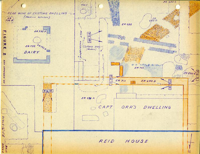 FIGURE 2
13
suggests that it may have supported a brick building the measurements of which indicate that it would have been a double pile structure.
FIGURE 2
13
suggests that it may have supported a brick building the measurements of which indicate that it would have been a double pile structure.
Immediately to the east of the colonial building was an area paved with a curious mixture of broken glass, tobacco-pipe fragments (of which there were more than 15,000) and a miscellany of small pieces of pottery and table glass, as well as a Queen Anne sleeve-button, and a quantity of lead shot of various sizes (Fig. 38, No. 17). A quantitative analysis of the tobacco pipe stem holes, using the Binford formula, produced a terminus post quem for the laying of the paved area of 1740.55.5 A few fragments of creamware were found in the top of the stratum as also were a smaller number of pearlware sherds. However, there is every reason to suppose that the paving had a long life. It was multi lated, though not necessarily destroyed, when the colonial house was torn down. Evidence for this was provided by the presence of material derived from it in the backfilling of the robbed building trench south of the Barlow House. Pipes bearing the same maker's mark as those from the paving were among items from the trench. Even more conclusive was the discovery of a single small fragment of English grey stoneware from the bottom filling of the east trench, which joined to one of many more fragments of the same stoneware mug (bearing an AR excise stamp, Fig. 32, No. 5) which were recovered from the paving itself. Dating for the filling of the robbed trench was indicated by 14 the presence of a well-preserved Virginia halfpenny of 1773 which was not issued in the Colony until March of 1775 (Fig. 37, No. 23). Fragments of a creamware cup were also retrieved from the bottom of the trench and this could not have found its way there until 1770 or later.
The paved area (Fig. 13) had been totally destroyed in the immediate vicinity of the east wall of the Reid House as a result of the rebuilding of its foundations. The paving had also been mutilated by the digging of large post holes which pierced it, east of the wall line, and which may have been dug for scaffolding erected when the Reid House was being constructed. The surviving, and more or less intact, stretch of paving was approximately 6'0" in width, having been mutilated beyond recognition at its east edge by nineteenth and twentieth-century planting, utility laying and also, apparently, by the dismantling of the adjacent store which occurred (as previously indicated) after 1861.
While the nature of the paved area is without parallel and its source cannot be explained, the purpose of placing it between the Orr House and the store was almost certainly to provide drainage for rain water falling from the store roof which was pitched on a north/south axis and so shed in that direction. The walk continued around the front of the house (See Fig. 8) at the same level and this, too, was characterized by quantities of pipe fragments, small potsherds and various-sized lead shot, all of which were scattered through two inches of packed dirt and marl. The front path (which extended 15 north from the Reid House to a surviving width of 6'3" at a depth of 10" below modern grade) contained much more marl than did the paved area and, furthermore, the pottery and pipe fragments thinned out and disappeared by the time the walk reached the north door of the existing house. It is probable, therefore, that the artifacts in the front walk had been tramped round from the paved area and had not been an intentional part of the path surface. The north walk was sealed by a later marl surface, 2" in thickness, and whose top lay 8" below modern grade. Artifacts sealed beneath this marl path dated up to the period about 1790-1810 (with one porcelaneous sherd apparently intrusive) and it is probable that the earlier north walk was abandoned around 1790 when most of the changes seemed to have been taking place on the property.
The first insurance plat of 1814 (Appendix V) showed a 6'0" shed attached to the east end of the existing house (Reid), and it was that which protected the remaining section of the paved area. Indeed, it was at first believed that the paving was actually laid as the floor for the shed.
The Store (Figs. 3, 14-17)
This was the building which was presumed to have been a blacksmith's shop, and whose robbed foundations left scant evidence in the ground. A building occupied this location on the Frenchman's Map though it was shown abutting against the Orr House, extending to the northeast corner of the lot, and measuring approximately 32'0" x 32'0". It may be significant that the building was shown to extend some 7'0" northward
 FIGURE 3
16
from the building line of the residence, thus placing the former on the same line as the houses in the adjacent Block 10. The 1814 insurance plat identified the northeast structure on Lot 15 as a store, and gave its measurements as "24 x 16 and shed 8", the shed being attached to the south end. The store was not then attached to the dwelling house. The building continued to be identified as a store on the insurance plats of 1823 and 1830, but no measurements were given. Then in 1839, it appeared as a "Cabinet maker's shop of wood 16 x 20." No shed was measured and none was shown on the sketch. In the plat for 1846, it was shown as a "Store all wood" and with a "Connection" linking it to the dwelling house. It remained the same in 1853, though the link was then described as a "covered way." No further illustrations are apparently extant and the only remaining information was that provided by Mrs. Lee who recalled that the store was still standing in 1861.
FIGURE 3
16
from the building line of the residence, thus placing the former on the same line as the houses in the adjacent Block 10. The 1814 insurance plat identified the northeast structure on Lot 15 as a store, and gave its measurements as "24 x 16 and shed 8", the shed being attached to the south end. The store was not then attached to the dwelling house. The building continued to be identified as a store on the insurance plats of 1823 and 1830, but no measurements were given. Then in 1839, it appeared as a "Cabinet maker's shop of wood 16 x 20." No shed was measured and none was shown on the sketch. In the plat for 1846, it was shown as a "Store all wood" and with a "Connection" linking it to the dwelling house. It remained the same in 1853, though the link was then described as a "covered way." No further illustrations are apparently extant and the only remaining information was that provided by Mrs. Lee who recalled that the store was still standing in 1861.
The only firm archaeological contribution is that the structure measured almost exactly 16'0" in width, thus supporting the documentary evidence of the 1814 and 1839 insurance plats. Only the southwest corner remained in situ and was situated on a line 1'5" north of the southeast corner of the existing (Barlow) dwelling house, a relationship quite different to that shown on the Frenchman's Map where the back of the store (?) stood some 9'0" north of the rear of the Orr House. It may be significant, therefore, that the distance from the store's south line to that of the robbed earlier house foundation 17 was close to 13'0". Thus, it may be argued that the roughness of the Frenchman's scaling and drawing would almost certainly have eliminated a 1'5" jog in a building line of two supposedly abutting structures; but he could hardly have ignored a return of 13'0", and the fact that he drew it to measure only 9'0" is well within the tolerance of the rest of the map. This evidence can be used to support the contention that the Frenchman was drawing the residence whose robbed foundations were found in the excavations, rather than the present Barlow House.
Returning to the store itself, it can only be said that it measured 16'0" in east-west width and at least 15'0" in depth. Both the east and west walls had been entirely robbed, leaving but a thin scatter of mortar and brick chips on the bottoms of their trenches. A half brick wall, or perhaps a fence seated on a row of bricks, had extended east from the northeast corner of the Barlow House in the late nineteenth century, as also had various wooden-posted fences. This repeated disturbance along the post Civil War north lot line had completely destroyed all traces of the front of the store. Using the 1814 measurements, (which were probably quite accurate) the northeast corner of the store would have been situated within the present area of the lot. Unfortunately, this key location had been completely destroyed by early Colonial Williamsburg planting. The northwest corner had been equally disturbed, but the cause could not be ascertained.
18Using the surviving southwest corner of the store as an anchor, projecting the building 24'0" northward would place the north wall inside the colonial lot line and only about 8" back from the north building line of Block 10. It will be recalled that the Frenchman showed both it and the store on the same line, and this, as far as he was concerned, would not be effected by a mere 8" difference. There is, therefore, evidence to support the contention that the Duke of Gloucester Street frontage of the Orr House and the store was more or less as the Frenchman showed it, i.e. the store projecting 6'0" northward — or 5'7" as suggested by the archaeological and 1814 insurance plat evidence. This argument can, therefore, be used to show that the present dwelling house occupied a north building line very close to that of the earlier residence and so strengthens the supposition that the original Orr residence was more or less square, measuring approximately 32'0" x 32'0". It may or may not be significant that the Blair Storehouse on the opposite side of Duke of Gloucester Street was a brick structure with comparable measurements. Precedent for the impending reconstruction of the latter is provided by a story-and-a-half double pile brick house "Seven Springs" in King William County whose measurements are also 32'0" x 32'0".
There is, unfortunately, very little that can be said about the appearance of the Lot 15 store building. The surviving fragment of brickwork at the southwest corner showed that the foundations were only one brick in thickness, and the only intact brick provided the following measurements: 19 8-3/8" x 4-¼" x 2-7/16", was a rich red in color, and retained some of its coarse oystershell mortar. A fragmentary T-shaped foundation was found running southward at the rear of the store — a foot more than was indicated by the shed shown on the 1814 insurance plat. The foundation was destroyed at both north and south extremities, and there was, therefore, no knowing whence it came or where it was going. A possible pier extended from it to the west, parallel with the rear of the store, but at only 6'0" from it. Consequently, one cannot accept this as being the extremity of the 1814 shed. No dating for these fragments (two courses deep and one brick in width) was forthcoming. The mortar appeared to contain shell, though very little of it survived, but the color of the bricks was less red than the one intact example from the store. It should be noted that the area south of the site of that building had been much disturbed by planting, the laying of utilities and the digging of a hole for an oil storage tank.
Running south from the north lot line was found a short stretch of possible foundation, one brick in width, one course deep and seated on sand. The sand layer extended over a post hole containing wine bottle fragments of the period 1820-1850 (Fig. 36, No. 4) and thus ensured that the bricks could not have been laid earlier. It is possible that they were part of a path leading to the front of the store, though they might represent the remains of a step or porch foundation. Specimen bricks measured 8-1/8" x 4" x 2-½" (pale salmon) and 8-3/8" x 4-7/16" x 2-3/8" (pale purple, with dog print).
20Inside the foundation area of the store was found a scatter of brick rubble and one brick possibly in situ which were all that remained of a small chimney-like foundation (Fig. 17) which possessed an interior (north-south) width of 3'6". If this was a chimney, it seemed to bear no relation to the supposed plan of the store, for it faced the west wall and had its southeast exterior corner only 5'6" away from it. The surviving traces had an interior depth of only 1'1", the west ends of the cheeks (?) having been destroyed by a modern utility cutting. A few fragments of iron waste lay on the natural clay immediately east of the foundation, and it might be tempting to claim both as evidence of a forge operating within the store area. However, the quantity of waste was much smaller than that found south of the Orr residence, and by that yardstick it was far too little to represent the residue of some twenty years of blacksmithing. Nevertheless, the purpose of the chimney (?) foundation remains open to conjecture.
Dating for the store was slight, and what there was was more than a little equivocal. Fragments of a late 17th century sgraffito pitcher from Bideford (Fig. 34, No. 6) were found scattered on the natural soil within and towards the rear of the store area. It is believed that their deposition predated the construction of the building, but that obviously helps very little. Much more unacceptable was the presence of a group of broken wine bottles of circa.1790-1810 (E.R. 673D) which rested predominantly outside the south wall line 21 of the store but also extended over the line (Figs. 15 and 36, Nos. 2-3). If one did not know better (from the insurance plat evidence) it would be supposed that the bottles were deposited after the foundation was destroyed, so giving the latter a terminal date around 1800. Even if we argue that the bottles were actually dumped down beside the building at that date and only spread across the robbed wall line when the bricks were removed, there still remains the question of how they managed to be deposited immediately outside the wall when we know from the 1814 insurance plat that that foundation was concealed beneath the 8'0" shed extension. The only reasonable conclusion must be that the extension could not have been there when the bottles were thrown away. It must, therefore, have been built after 1790, and before 1814; thus placing this change within the period of so many other alterations to the property.
The Carriage House (Figs. 4, 18 and 19)
Situated on Colonial Street and southeast of the existing kitchen lay the foundations of the carriage house which first appeared on the 1814 insurance plat. (See Appendix V). No building was shown in that location on the Frenchman's Map, nor did it appear on the insurance plats for 1823, 1846, or 1853. But just to prove that one cannot set too much store by the drawing of insurance plats, it did show on those of 1830 and 1839. Only the 1814 plate gave the measurements for this building which were quoted as being "17 x 14." A 22 building measuring 14'0" x 17'0" and described as a "shed" stood on the same location as recently as 1930, but it was considered to have been of no antiquity and was later removed.
The excavated foundations were much mutilated, and all traces of the south wall had vanished. Nevertheless, it was determined that the building had been 14'0" in width, and at least 13'0" in length. The bricks varied widely in size and color and were largely bats, and where mortar remained, it was found to contain equally widely varying quantities of shell. Numerous post holes cut through the east foundation wall, and it must be assumed that these were dug by Colonial Williamsburg; other post holes were sealed beneath the foundation, and at least two of them contained ceramics dating up to 1790. The latter, therefore, provided a terminus post quem for the construction of the carriage house.
The Eighteenth-century Kitchen (Figs. 5, 20 and 21)
The Frenchman's Map is more of a hindrance than a help in trying to determine the placement of buildings at the rear of the Orr House. The residence, itself, is shown overlapping the west lot line by some 12'0", and abutting against a slender building which is wholly on the adjacent lot. The west line of Lot 15 stops short of the house by about 9'0", and against the west face of a small secondary building which was probably the kitchen. On the 1814 insurance plat we find in that location, "Kitchen wood entire 16 x 20 and shed 8 feet Shed" (sic), the shed being attached to the south end of the building. A
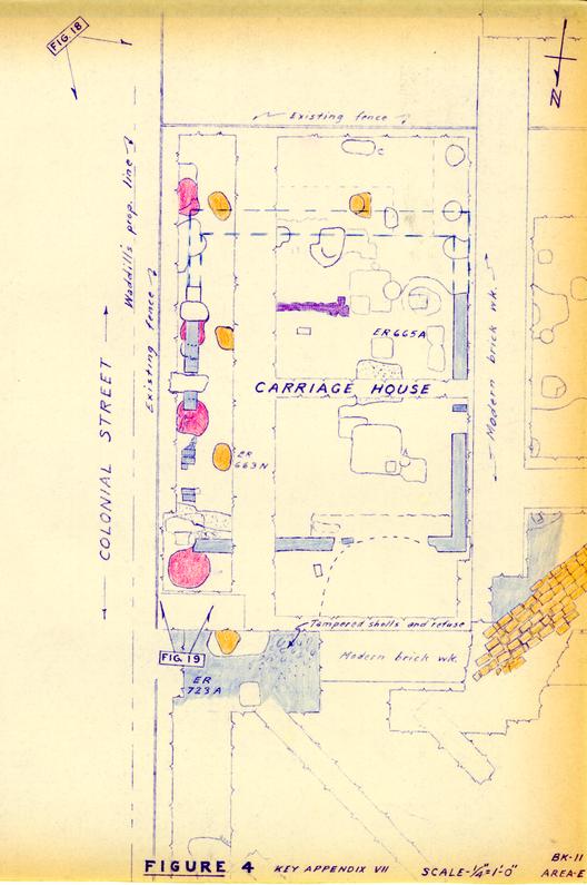 FIGURE 4
23
kitchen of similar proportions appeared in the same vicinity on all the subsequent insurance plats from 1823 to 1853.
FIGURE 4
23
kitchen of similar proportions appeared in the same vicinity on all the subsequent insurance plats from 1823 to 1853.
The 1928 Colonial Williamsburg excavations revealed the foundations of a building using shell mortar in the kitchen location, and its measurements were 16'0" x 20'0". Although no evidence of a southerly shed was recorded at that time, the re-excavation of 1963 did uncover the somewhat mutilated foundations of a southerly addition whose north-south measurement proved to be 8'2", leaving little doubt that this was the structure shown on the 1814 plat. These recent excavations also revealed the remains of the foundation for a northerly extension to the same kitchen, part of whose brickwork lay beneath the existing smokehouse. The north extension provided a north-south measurement of 10'2" and artifacts overlying it, and sealed beneath the north foundation of the smokehouse, indicated that the latter had been installed no earlier than circa.1790-1800. But, as the 1814 insurance plat indicates a smokehouse between kitchen and residence, one may reasonably deduce that the kitchen's northerly extension was torn down and another slightly smaller lean-to was added to the south end when the smokehouse was built (and the various other changes occurred to the property) in the last decade or so of the eighteenth century. The Frenchman shows the supposed kitchen building measuring approximately 18'0" x 18'0", and if he is taken literally, it could be construed that no extension existed when his map was drawn; in which case, the
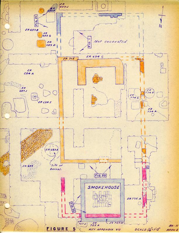 FIGURE 5
24
north lean-to had either been removed by 1782, or had not yet been erected.
FIGURE 5
24
north lean-to had either been removed by 1782, or had not yet been erected.
The interior of the kitchen had been much disturbed by planting and previous excavation. Furthermore, an entirely arbitrary west lot line cut through it, causing even further damage to the archaeological evidence. Nevertheless, considerable quantities of iron waste and slag were found in a burned stratum inside the kitchen close to the modern fenceline, and there is every reason to believe that this escaped disturbance, but it has not been resolved whether the waste was deposited inside the building during its early life, or whether it was there before the kitchen was built. On the face of it, the latter explanation seems most reasonable, as one would hardly use the kitchen for the deposition of such trash. If the refuse pre-dates the kitchen, then it follows that the building must have been constructed after ironworking commenced on the property.
The kitchen chimney had been considerably damaged by the planting of boxwood, but it was found that it had interior measurements of 5'6" x 2'3", and was of average, but not generous size. The remains of at least two successive brick hearths, each bedded on clay, were encountered and artifacts sealed under the lower bricks (E.R. 694.J.) dated in the period circa.1790-1810. This evidence points to the laying of a hearth in the period of change (presumably after the death of Mrs. Orr) and when the other alterations were being made to the kitchen. The key question is whether these 25 changes might also have included the rebuilding of the chimney. In any case, they must have entailed the construction of a doorway through to the new extension, either east or west of the fireplace.
Fragments of a Spanish oil or olive jar and pieces of a Yorktown pipkin (Fig. 34, No. 7) were found in a layer of oystershells and iron slag (E.R. 694.E.) which passed beneath the lower hearth and extended westward out beyond the west wall of the building, thus adding weight to the contention that the kitchen was erected after Hugh Orr started work on the property.
The kitchen was approached by a brick walkway heading in a northeasterly direction toward the house. The date of the path's construction has not been satisfactorily established, though there is no reason to doubt that it was laid in the eighteenth century. The path is important in that it indicates the position of the kitchen doorway in the east wall with its south jamb at a point no more than 9'10" from the northeast corner.
The brick walk overlay the filling around a circular hole some 2'2" in diameter which might have housed a rain barrel set into the ground. While it is clear that the "barrel" was in position before the path was laid (indicating the kitchen) it could not be determined whether the path postdated the barrel's removal. In all probability, however, the two were in use contemporaneously.
26The objection to the barrel theory is that the diameter of the hole was only 2'2" but it terminated at a depth of 1'8" below the surface of the path. A barrel with a base diameter of 2'2" would probably have stood no more than 3'6" in height, in which case there would have been no point in setting it into the ground. On the contrary, it would have been desirable for a rain barrel to have been raised on bricks to prevent rotting of the stave ends. Alternatively, it is possible that the hole seated a tub which was used for planting purposes.
The Smokehouse (Figs. 5 and 22)
There is good reason to suppose that parts of this structure date from the George Reid period, though the little building has obviously been frequently repaired through the years. It measures 8'3" x 8'0" (approx.) and, as previously stated, its foundations overlie the remains of the kitchen's north extension and whose north foundation passes beneath both the brick hearth and the east and west walls of the smokehouse. Beneath the latter's north wall, and immediately outside that of the kitchen extension, was found a deposit of dark grey soil containing bottle and ceramic fragments (E.R. 707H dating in the period circa 1790-1810).
It is believed that parts of the present smokehouse were in this location prior to 1814, and that it was placed there as part of the major changes which occurred on the property in the late eighteenth century. There is a remote possibility 27 that the structure was moved to its present position from a site elsewhere on the lot. Part of a colonial outbuilding foundation approximately 8'3" in width was discovered to the west of the well (Fig. 6), but it is more likely that the foundation had housed a dairy - possibly the one which was shown on the 1814 insurance plat and which was discovered beneath the floor of the modern kitchen extension to the George Reid or Barlow House.
The smokehouse foundation is one brick in thickness and is topped by wooden sills which have been notched, suggesting that at some time the building possessed a wooden floor. In the center of the building was found a brick paved area, (Fig. 22) but because it was mutilated on all four sides, it was not possible to determine whether this feature had been merely a central hearth or whether a brick floor had originally continued to the walls. The bricks rested on a pad of yellow clay at the edges, but which was dished out in the middle and contained a filling of black soil. Artifacts from the black deposit dated from the period c.1790-1800 (E.R. 707D) and would be consistent with the changes attributed to the Reid period.
As previously mentioned in discussing the adjacent kitchen, the north foundation wall of the kitchen's north extension passed beneath the smokehouse and abutted against its north wall. Artifacts from grey soil beneath the earlier footing (E.R. 707E) dated from the first half of the eighteenth century, and thus provide a terminus post quem for the construction of the kitchen addition.
The Dairy (Fig. 2)
This building was illustrated on none of the extant insurance plats, but was mentioned by name on that of 1814, as also was the "Smoke House." The placing of the legends at either end of the rear of the Orr residence, with the work "Dairy" written immediately south of the shed attachment to the east end of the house, suggested that these locations were approximately correct. It seemed likely that the smokehouse and dairy were a pair, and as the former apparently still survived, it seemed reasonable to expect to find traces of the dairy on the same line. The removal of the modern kitchen floor and subsequent careful excavation beneath it revealed three corners of the dairy foundation, and artifact evidence to show that it overlay ceramic fragments of the period 1790-1810. The foundation measured approximately 8'0" x 8'0", was one brick in thickness, and made use of shell mortar. As indicated when discussing the smokehouse, it is possible that the dairy was moved from a location immediately west of the well (Fig. 23) when the site was being developed in the Reid period.
It may be noted that a water-worn channel, possibly a roughly cut and much eroded drainage ditch, passed beneath the dairy foundation heading in a southeasterly direction, and contained sandy silt from which were recovered numerous artifacts of the Orr period (E.R. 732F-H).
The Well (Figs. 6 and 24)
This feature possesses the restored head which had been part of it prior to the lot's acquisition by Colonial Williamsburg. The head had been removed and sold to a resident of Richmond in the late 1920's, from whom it was later re-purchased. It would seem that when Lot 15 was restored, the foundation of the well had been stripped down to ground level, and was subsequently rebuilt to an arbitrary elevation when the head was brought back. The top of the foundation exposed in 1928 indicated that the head should stand parallel with the south wall of the modern kitchen, and, for that matter, with the dairy building discussed above. However, only one course of the well's old brickwork survived on this alignment; beneath that, the head foundation continued downward for a further four courses, thus setting the head on a north-northwest - south-southeast line, and at a skew to the dairy. Abutting against this earlier foundation was part of the rubble spread of 1790-1810 which marked the destruction of the Orr House; but the debris overlay the back filling around the old head footing and, therefore, post dated it. On the other hand, the straightened well head course rested on top of the Reid period spread, indicating that it was of later date. There was no evidence to show how much later the new alignment had been decided upon; it could have occurred a day, a year, a decade or more after the Orr House debris was spread around. It is clear however, that the earlier alignment was in existence before the Orr House was torn down. The well was not excavated,
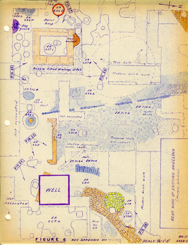 FIGURE 6
30
and, as it still contains water, it is unlikely that any useful information as to its date of construction would have been forthcoming.
FIGURE 6
30
and, as it still contains water, it is unlikely that any useful information as to its date of construction would have been forthcoming.
Timber (?) structure east of Kitchen (Figs. 6, 25 and 26)
This undoubtedly colonial feature was represented only by a trench having an average width of 1'3" and enclosing an area measuring 5'0" x 3'7". The trench had been dug into natural clay probably to seat the bottom of a timber frame having a vertical member in each corner, impressions of the latter being visible in three of the four corners. Along three sides of the trench bottom were a series of crescent-shaped holes of varying size. These had the appearance of having been dug with a round-ended spade to seat the bases of vertical boards pushed down against the exterior faces of the trench, and held in place behind the horizontal framing. Outside the north and east faces of the structure, another abutting ditch had been dug and filled with brick rubble and oyster shells, apparently for drainage purposes. When the wooden unit was dismantled, the brickbats remained in position but the inner trenches were partially filled with ashes and clinker probably associated with Orr's ironworking. Beside the supposed wooden structure at the north, and overlying the previously mentioned brickbat-filled cutting, was found a large rusted conglomeration of iron waste which was taken apart in the laboratory and found to contain many small scraps as well as recognizable fragments of chain links, knives, hinges, lock bolts, rim locks, a smoothing iron handle, nails, bolts and a key.
31The purpose of the wooden (?) structure has not been determined, though it has been suggested by Mr. A. E. Kendrew that it might have been an ash house for the storage of ashes for making soap. Mr. Burke Davis has proposed that it might have been part of an actual unit for the leaching of soap ashes. The lower hoop from a small barrel or tub was found seated in the ground to the west of the unit, (Fig 27) and it is conceivable that this might have been associated with it. Finds from within the hoop circle comprised ceramics and glass of the second quarter of the eighteenth century.
Walkways (Fig. 8)
The remains of at least three brick walkways were found in the yard area immediately south of the Reid House and its attendant outbuildings, all save one of them undoubtedly being associated with the post-colonial era of lot improvement. The principal path ran from the rear (south) door of the Reid House down the length of the property and terminated beside the east wall of the stable at the extreme south of the lot on Francis Street. This path was of brick from the house to a point midway between the Dairy and well, whereupon it continued as a marl walk bordered by brickbats. It was then lost, due to the presence of Colonial Williamsburg flower beds and the boxwood garden, but was picked up again in the orchard (without brick sides) and traced through to the stable indicating, incidentally, that in all probability a doorway provided access into the stable through its east wall.
32The best preserved section of brick walk (Fig. 2 and 29) struck out from the north-south stable path at a point some 7'0" from the existing south porch and proceeded in a southwesterly direction to the kitchen. A V-shaped drain had originally been part of the walk allowing water to drain across it on a northwesterly line; but this had later been replaced by a more carefully constructed, bricksided drain which apparently sloped in the opposite direction and was cut through by a large 19th century brick cistern beside the west wall of the present kitchen extension.
The area east of the long north-south walk was apparently made into a rubble paved yard using materials derived from the destruction of the Orr House, and this continued through to the Colonial Street property line. However, it was divided by a curving brick paved walk (Figs. 6 and 28) extending from the north face of the well head and curving a northeasterly direction toward the aforesaid street. Close to the well, and partially beneath the curving path, was what appeared to be a shallow brick-floored sump which was largely filled with water-washed sandy silt. The purpose of this feature was not determined. There was no evidence of any brick path extending from the well to either the colonial kitchen or to the house, and it was all the more curious, therefore, that the only path led away from these structures toward the street. As the east end of the walk had been destroyed, it was conceivable that it had originally taken a sudden northward turn and had led to the back of the store.
33A small section of brickbat paving was found overlying the south edge of the robbed wall trench of the Orr House at a point approximately 1'0" east of the southwest corner of the modern porch. This walk obviously postdated the Orr House, but no other evidence was forthcoming to determine whether it was laid in the late 18th or in the 19th century.
The only sections of undoubtedly colonial walks and paving were those of tobacco-pipes, trash and marl running between the Orr House and the store, and in front of the residence beside Duke of Gloucester Street. These features are discussed elsewhere (see p.13ff).
Fencelines
Large numbers of post holes were found in the vicinity of the house and outbuildings, but their relationships, one to another, were uncertain. It must be understood that a post hole can generally be dated on three pieces of evidence; 1) by overlying strata which provide a terminus ante quem for the post's removal, 2) by artifacts in the back fill of the post mold which provide a terminus post quem for the removal, 3) artifacts in the back fill around the post or post mold which gives a terminus post quem for the post's insertion.
Over most of the site, earlier 20th century excavation and grading had destroyed or disturbed the overlying strata. In addition, the looseness of the back fill around most of the posts was such that no post molds survived, and consequently, 34 it was not possible to determine whether the artifacts had found their way into the holes when the posts were erected or when they were removed. In most cases, it was only possible to determine that the removal of the posts could be no earlier than the date of the latest object found in the fill. In using this evidence it must be remembered that a terminus post quem is exactly that, the date after which the post was removed — any date from a few weeks, to years, or even centuries.
With these reservations, it is still possible to learn something about at least one colonial fence as three post holes were sealed by a colonial stratum which had been protected, throughout the 19th century and from the 1928-30 restoration landscaping, by the presence of an overlying carriage house and shed. These three holes were part of the Orr period fence-line on Colonial Street (Fig. 8 Line A-B) and probably extended through to the southeast corner of the store building where another early post hole was encountered. This important piece of evidence indicates that the colonial property line lay some 3'0" to 4'6" west of the present fence. The absence of other post holes on this line between the store and carriage house is explained by the fact that the area has been subjected to considerable disturbance during the past forty years.
There is a remote possibility that a colonial fence-line ran north-south between the Orr House and the store (Fig. 8, Line G-H). Unfortunately, the tops of the holes had been mutilated and it could not be determined whether 35 they cut through the paved area (pipe-stem deposit) or were originally sealed by it. The few artifacts from the two holes were consistent with an earlier date (c.1725-40). However, it is obvious that such a fence would not have been contemporary with the paving, and as that feature has been established as extending through the Orr period until the destruction of the house, it follows that the fence (if such it was) has no bearing on the principle period of interest.
The largest concentration of post holes ran east-west across the site south of the well and kitchen. The tops of all of them had been disturbed by grading, and Colonial Williamsburg planting, the later extending to depths lower than the bases of some holes, thus raising the possibility that others had been totally eradicated. A possible colonial line (Fig. 8, Line B-C) is created by those holes containing nothing but artifacts of the appropriate period. It will be noted that the conjectural south wall of the early dairy (?) does not fit this line.
So plentiful are the post holes running east-west that there is little doubt that approximately the same line was maintained through both the 18th and 19th centuries. A second line of probable colonial posts (Fig. 8, Line E-F) ran more or less parallel to, and 2'6" north of line B-C. A further colonial line (Fig. 8, Line C-D) ran north from point C on a course approximately 2'6" east of the kitchen foundation. It is possible, however, that this line represents 36 scaffold pole holes belonging to construction or repair work associated with the kitchen.
It should be noted that the Frenchman's Map shows a fenceline extending south from the southwest corner of the kitchen, but this line was not found in the test holes dug for that purpose. The existing west property line is, of course, a modern innovation and overlies the foundations of the kitchen some 4'0" to the east of the building's west wall.
The north fenceline, which existed until the present residence was restored, extended east and west from the north wall of the building. That fence was seemingly repaired or rebuilt from time to time, one of the changes entailing the laying of a single course of bricks below the palings. It may be deduced that the eastern section at least post-dated the destruction of the store in the third quarter of the nineteenth century. It is debatable whether or not there was a fence on the colonial north lot line in the 18th century. The stratigraphy north of the house had been much disturbed in recent times. However, one post hole containing nothing but colonial artifacts was found cutting through the marl and refuse walkway which had passed in front of the Orr House.
The Lumber Yard (Figs. 8 and 30)
Excavations in the lawn area south of the fenced garden and east of the boxwood garden revealed impressions of at least six sleeper timbers running in an east-west direction, and part of another running north-south.
The impressions were of differing lengths and suggested 37 that they were the marks of wood haphazardly layed on the ground and pressed into it by weights placed on top of them. Such a footing is still used in lumber yards, and it is significant that in the 1839 insurance policy, the store was described as a cabinet maker's shop.
Artifacts found in the bottoms of the impressions dated into the second quarter of the nineteenth century, thus giving a terminus post quem for the laying of the wood consistent with the cabinet-making operation.
The Dog Burial
To the south of the existing residence and immediately north of the Colonial Williamsburg east-west fence was found the interred remains of a small dog. (Fig. 31) Strata over the grave had been disturbed down to the natural clay on either side of it, and, therefore, no terminus ante quem was forth-coming. However, the grave filling contained one fragment of Yorktown earthenware which indicated that the burial could not have occurred before circa 1725; but in the absence of evidence to the contrary, it was conceivable that it dated from the colonial period. Some doubt as to the validity of this evidence was created by the realization that the grave would have situated outside the colonial fencelines. As there was every reason to suppose that the remains were those of a pet dog which would have been laid to rest with some grief, it seemed unlikely that it would have been denied the protection of the garden fence. Efforts were then made to determine whether Miss Barlow had owned a pet dog. At first we were told that she 38 had not, but subsequently, the late Mr. R. Kyger stated that she had, and that it had been shot when Miss Barlow was quite young (c.1881). He also recalled that the dog's name was "Toby." At Mr. Kyger's suggestion a letter and a plan of the grave location were sent to Miss Barlow's elder sister at Onancock, Virginia. Her daughter, Marion Claremont Daniel, replied as follows:
June 6, 1963
"In reply to your letter of May 31st., I have talked over the matter of Toby's breed, date of death, etc. with my mother, who says that her father, John H. Barlow, bought the dog from a British sailor whose ship was anchored at Yorktown. (Grandfather afterwards strongly suspected that the little dog had been stolen from someone aboard the ship, though this was never proved.)
Mother says that the dog was said to have been a Scotch terrier. He was very much given to hunting and killing rats, which, incidentally, was the cause of his death.
He followed the family to church one night and was, naturally, put out. He apparently went to the Braithwaite barn where he had found his kind of hunting especially good. He was shot by Willy Braithwaite while there.
The incident occurred when Mother was ten years old, and she is now ninety-two, which would make the burial about eighty two years ago. The place of the grave as shown on your drawing was exactly as Mother remembered it.
Other than the above facts there is not much to tell, except that Toby was highly intelligent and apparently very forbearing with the little girls who adored him. He was sandy haired and had very bright black eyes."
The Williamsburg veterinarian, Dr. John A. Finnegan, has examined the skeleton (which bears no evidence of gunshot wounds), and he fails to agree with the identification of the breed, feeling that it was more likely to have been akin to a King Charles spanniel.
39The burial is of interest, first because it represents a fragment of Williamsburg history, and second in that it reminds us that termini post quem must be used with extreme caution.
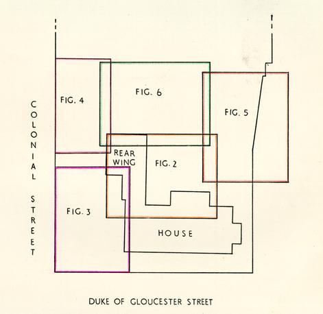 Fig. 7 Plan of excavated area showing relationships of Figures 2 - 6.
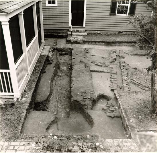 Fig. 9. Robbed south wall of Orr House as exposed south and west of existing structure. Photo from the west. 63-GR-651-3
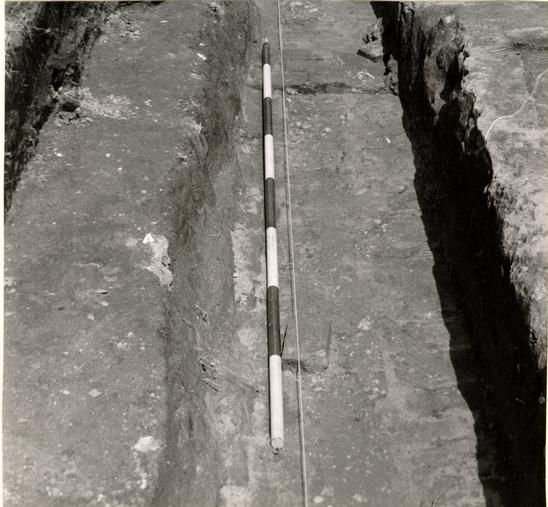 Fig. 10. Detail of robbed south wall of Orr dwelling showing impressions of its bricks in the clay trench bottom. Photo from the west. 69-INH-1495
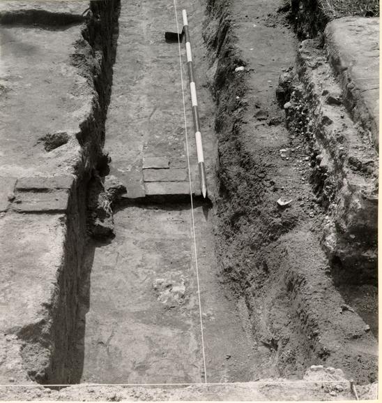 Fig. 11. Detail of robbed south wall of Orr dwelling showing surviving bricks in situ. Photo from the west. 69-INH-1493
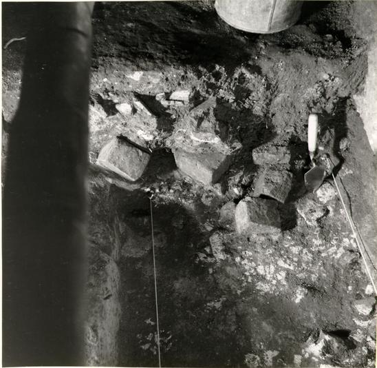 Fig. 12. Detail of robbed east wall of Orr house exposed beneath passage between existing house and kitchen. Photo from the south. 69-INH-1487
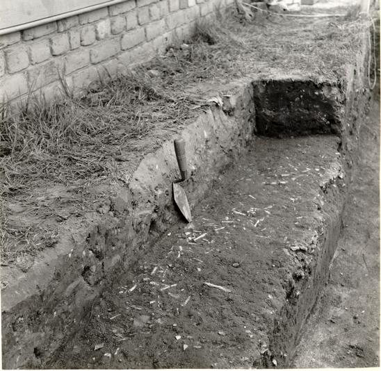 Fig. 13. Part of tobacco pipe and glass fragments used in paving contemporary with Captain Orr's Dwelling, and partially destroyed when the house was dismantled. Photo from the southeast. 69-INH-1478
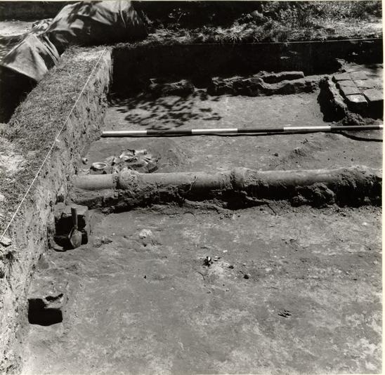 Fig. 14. Remains of store south foundation, southeast corner in foreground. Note deposit of c.1800 bottles on wall line beyond modern utility pipe. Photo from the west. 69-INH-1477
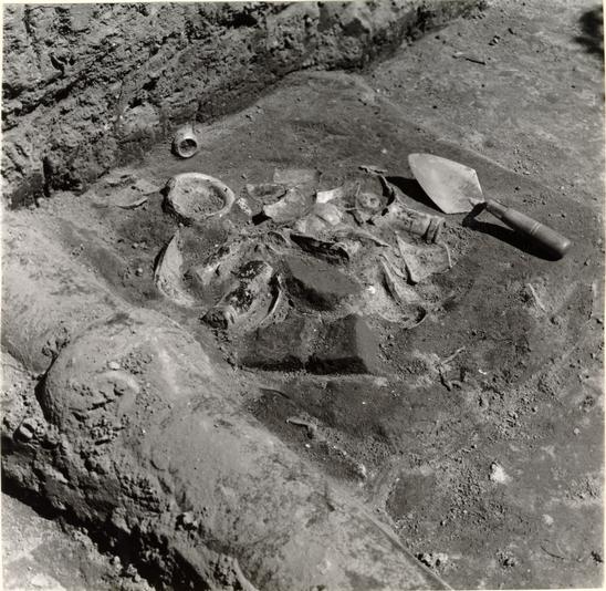 Fig. 15. Deposit of broken bottles, c.1800 on south wall line of store. Photo from the southwest. 69-INH-1479
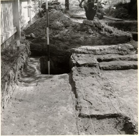 Fig. 16. Robbed southeast corner of store indicated by string lines. The ranging pole stands in a post hole of the colonial fenceline. Photo from the north. 69-INH-1490
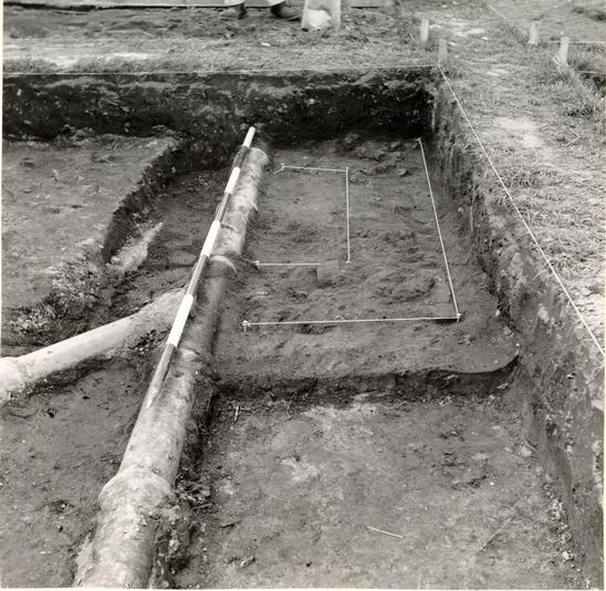 Fig. 17. Remains of small chimney (?) foundation inside store. Photo from the south. 69-INH-1492
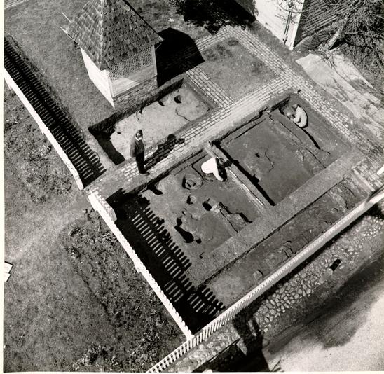 Fig. 18. Foundations of carriage house in course of excavation. Photo from the southeast. 63-GR-229-13
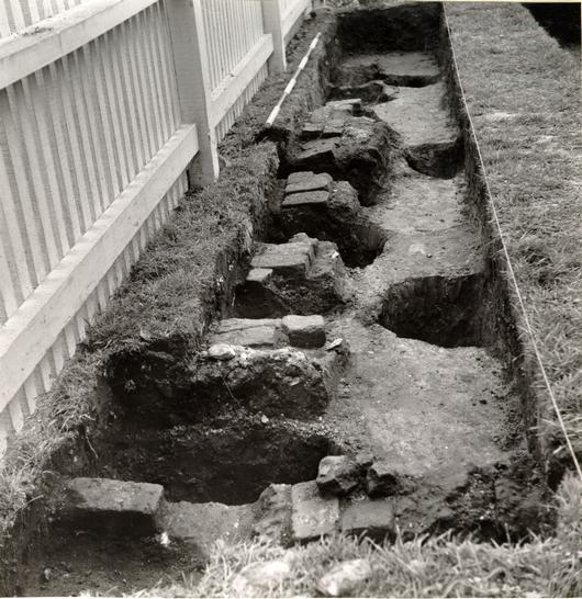 Fig. 19. Remains of east foundation of carriage house cut through by later post holes and with colonial fenceline to right. Photo from the north. 69-INH-1491
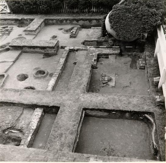 Fig. 20. Foundations of eighteenth-century kitchen with interior chimney, and remains of hearth. Photo from the north. 63-GR-651-51
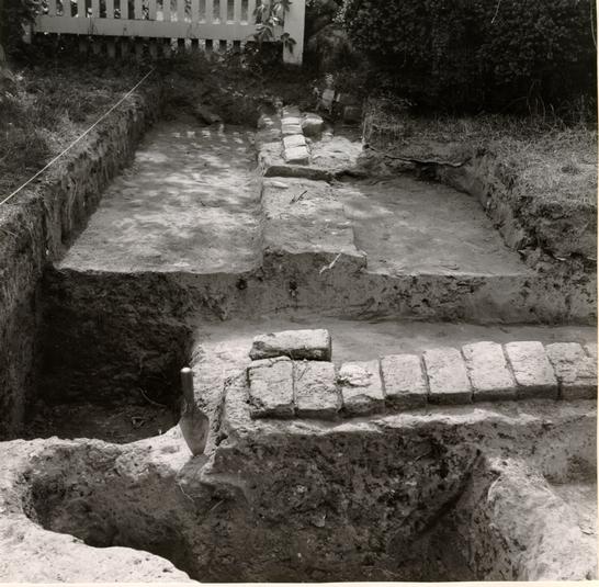 Fig. 21. South extension to kitchen showing southeast corner. Photo from the east. 69-INH-1484
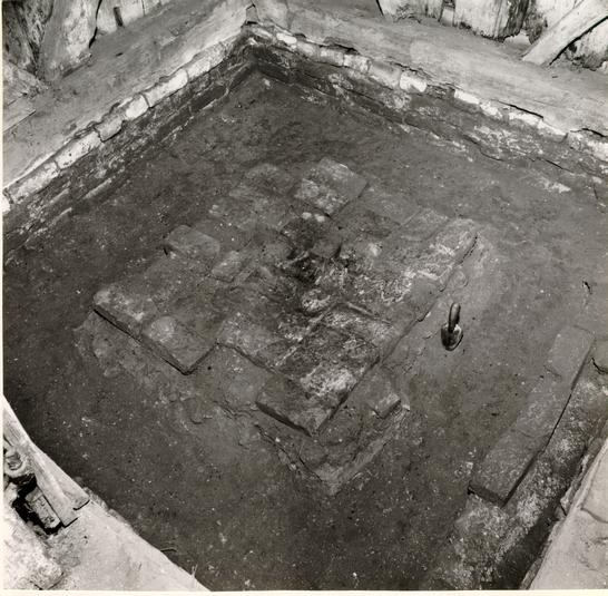 Fig. 22. Interior of exposed smokehouse after excavation showing brick hearth area, and north wall of earlier kitchen extension foundation at right. Photo from the northeast. 63-GR-651-2
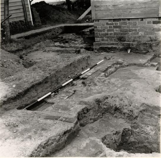 Fig. 23. Remains of north wall and northwest corner of possible colonial dairy west of well. Photo from the southwest. 69-INH-1486
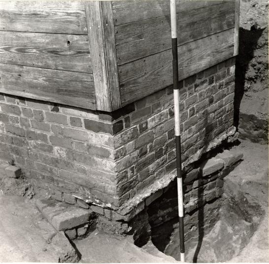 Fig. 24. Detail of well head showing one course of the nineteenth century head on which the reconstruction is seated, and beneath, the colonial well head foundation four courses deep. Photo from the southwest. 69-INH-1488
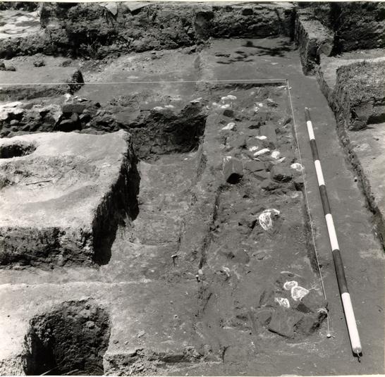 Fig. 25. Shallow trench filled with shells and brickbats, possibly for drainage, against east wall of unidentified timber structure. Photo from the south. 69-INH-1482
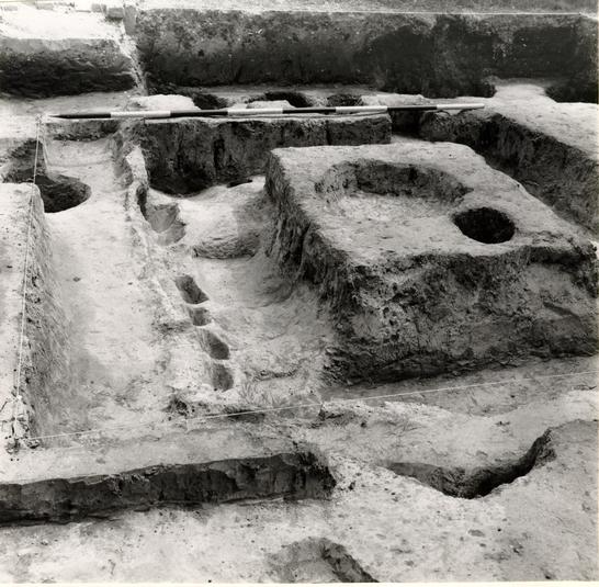 Fig. 26. Impression of timber structure after excavation and following removal of rubble-filled drainage trench illustrated in Fig. 25. Photo from the north. 69-INH-1481
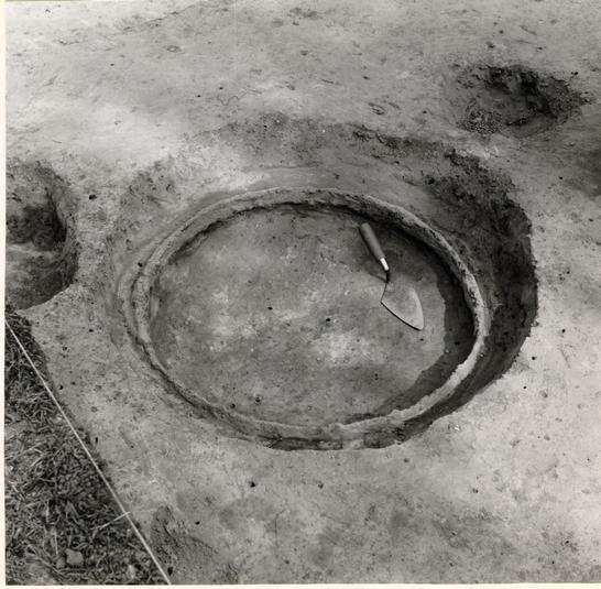 Fig. 27. Shallow pit with iron barrel hoop at bottom immediately west of unidentified timber structure. Photo from the northwest. 69-INH-1485
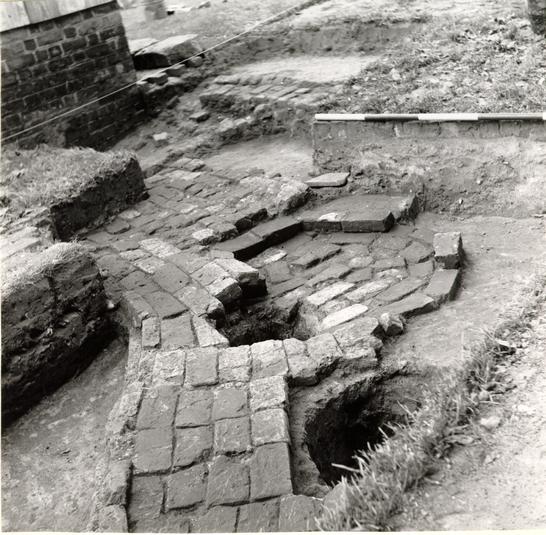 Fig. 28. Brick walk leading to well with unidentified hexagonal feature at right, and with later shallow brick drain in background. Photo from the northeast. 69-INH-1489
Fig. 29. Walkway to kitchen showing early brick drain cut through by later drainage channel. Photo from the east. 69-INH-1480
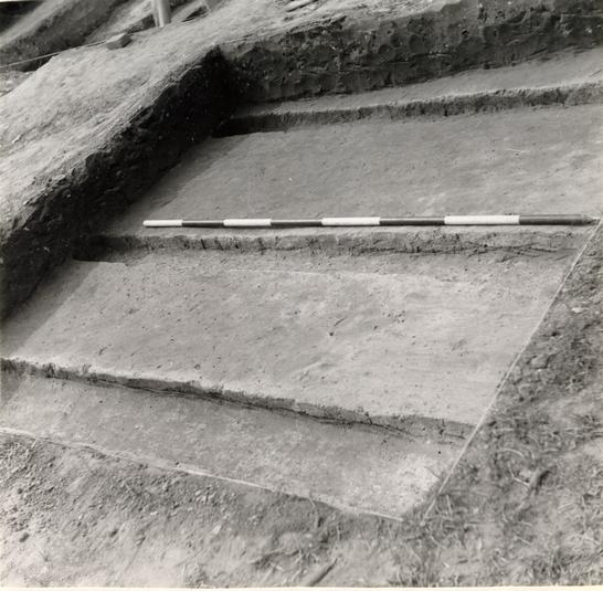 Fig. 30. Shallow trenches running east-west, south of the Orr well, probably impressions of sleeper timbers layed down when the property was occupied by a cabinet maker. Photo from the southeast. 69-INH-1483.
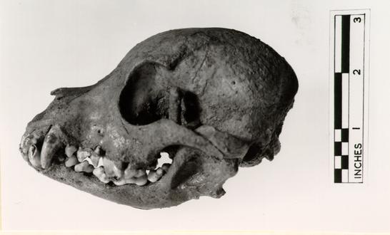 Fig. 31. Skull of small dog (with forefoot bone pressed up into left eye socket) almost certainly Miss Emma Lou Barlow's, "Toby" which was buried in the garden c.1881. 69-INH-1494
THE GEORGE REID HOUSE SITE
(Colonial Lot 15, Block 11, Archaeological Area E)
REPORT ON ARCHAEOLOGICAL EXCAVATIONS
FEBRUARY TO OCTOBER, 1963
PART II
THE ARTIFACTS
January 1970
Prepared by: Audrey Noël Hume
The Excavated Artifacts
Although large numbers of artifacts were retrieved in the course of the excavations, only a small percentage provided useful dating evidence, and very few items were sufficiently intact to be worthy of exhibition. The principle dated deposit came from the "pipe stem" paving between the existing house and colonial shop. Although somewhat contaminated by later intrusions, the body of the deposit could be dated around 1740 on the evidence of the tobacco pipe fragments. The significance of these is discussed in Appendix II.
Sealed amid the pipe stems were numerous pieces of lead shot, a sleeve-link bearing a portrait of Queen Anne, and fragments of Burslem stoneware mugs bearing AR excise stamps. Scattered through the roughly paved area between the present house and the well were many ceramic and glass items dating from the second half of the 18th century, and deposited after the Orr House was destroyed. Notable among these was a wine glass stem containing an elaborate twist in opaque white, outlined in red, green and blue. This item is the first of its kind to have been found in Williamsburg.
A small group of broken, late 18th to early 19th century wine bottles was found to the rear of the shop foundation, and another intact bottle was discovered in a post hole west of the colonial kitchen.
Many artifacts were found in the topsoil, most of which had been turned over in the course of previous Colonial 41 Williamsburg archaeological and landscaping projects. The most significant and interesting artifacts, both stratified and unstratified, are illustrated in Figures 32-38, and are described on the following pages. Unless otherwise stated, these are believed to be of British manufacture.
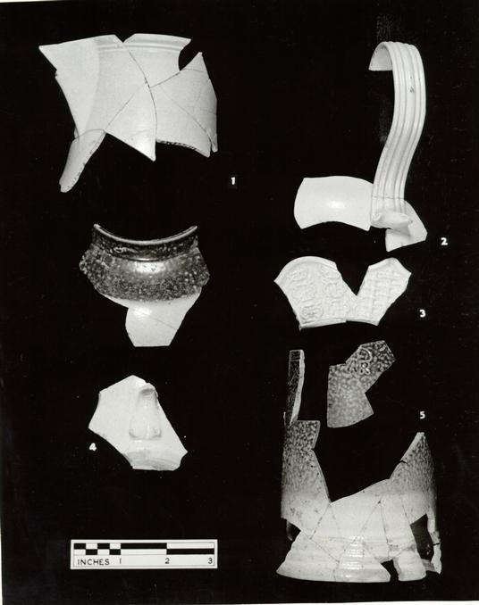 Fig. 32 Ceramics
Figure 32
- 1 & 2.Neck and handle portions of a white saltglaze stoneware pitcher with pointed spout, multi-grooved handle and cordon below the slightly everted rim. The lower end of the multi-readed handle has been pressed back on itself. Enamelled jugs of this shape bear dates ranging from 1751-1763.
Date of Deposit: post 1790.
[2571. E.R. 687J-11.E.] - 3.Marly fragment of white saltglaze plate with wavy edge and unusual molded design. One panel consists of rows of triple quatrefoil units, dissected diagonally by four "pins" and a St. George cross in the interior with a pair of dots at each end of the horizontal line. Next to this is a panel in the familiar "basket-weave" design.
Date of Deposit: post 1770.
[2572. E.R. 665A-11.E.] - 4.Rim and base fragment of small tea or punch pot of white saltglaze stoneware. The body is a coarse grey dipped in a slip of a whiter, finer clay. The shoulders and rim have been finally dipped in a ferruginous slip which has fired to a rich red brown. The object was held by the base for the final dipping and the slip
43
penetrated only a short distance on the inner rim. The pot is globular in shape, with a vertical collar and a small, round-sectioned handle, smeared down flat at its lower end with a diamond-shaped impression to strengthen the luting. The base is thin, recessed within a flat, wide, footring and with kiln impurities still attached. This was found in association with a large group of clay tobacco pipe fragments which formed a floor laid down about 1740.1 English.
Date of Deposit: post 1740.
[2573. E.R. 668C-11.E.] - 5.Mug of Burslem saltglaze stoneware, the body being of a grey clay dipped into a slip of a fine, whiter clay. The upper two-thirds and the interior were coated with a ferruginous slip which fired a mottled brown. There is a single groove below the exterior of the rim, and the excise mark of Queen Anne 1702-1714 (the cypher AR surmounted by a crown) has been stamped onto the body below this groove. There are four cordons above a flat base. Fragments found in excavations at Burslem in Staffordshire parallel both the ware and the stamp.
Date of Deposit: post 1740.
[2574. E.R. 668B & C-11.E.]
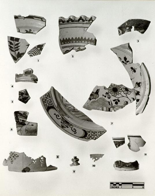 Fig. 33 Ceramics
Figure 33
- 1.Three fragments of a round plate of tin-glazed earthenware (delftware). The rim is decorated with a band of two lines with the space between divided diagonally into parallelograms, alternately plain and cobalt-filled. In the center of the plate is a spiral design surrounded by square brush stroke leaf sprays. All the decoration is in blue.
Date of Deposit: post 1800
[2588. E.R. 715, 684A, 682-11.E.] - 2.Portion of round bowl of tin-glazed earthenware (delftware) with frilled edge, the latter is decorated with a wide, blue, inverted chevron alternating with three vertical red lines. Upper and lower groups of lines on the bowl close to the rim are in blue, and there is a row of pale green diamonds close to the lower group of blue lines. The central decoration has been found from other fragments to be floral in character and executed in green, red, and blue. A fragment of a similar bowl was found at the Semple House (2589-2BI) and an example with green instead of blue chevrons came from the Anthony Hay site (2591. E.R. 243L-28.D.). Other examples of bowls of this type bear portraits of George I and the Duke of Ormonde
45
(these in the Glaisher Collection) and Queen Anne (in the Victoria and Albert Museum). Probably Bristol.
Date of Deposit: post 1730.
[2590. E.R. 686E-11.E.] - 3.Portion of bowl of tin-glazed earthenware (delftware) plain on the interior except for two blue lines close to the rim. The exterior is decorated with sponged manganese and fishes outlined in cobalt. The foot is missing.
Date of Deposit: post 1790.
[2593. E.R. 663N, 723A-11.E.] - 4.Portion of rim and handle of porringer of tin-glazed earthenware (delftware). The interior of the vessel appears to be undecorated, while the upper portion of the handle has blue and manganese areas; also a shaped center hole.
Date of Deposit: post 1740.
[2594. E.R. 668B-11.E.] - 5.Fragment of bowl or posset cup of thin-glazed earthenware (delftware). Plain on the interior and with exterior floral-type decoration in blue, green and red, applied in that order.
Date of Deposit: post
[2595. E.R. 707J-11.E.] - 46
- 6.Bottom right-hand corner of a tile of tin-glazed earthenware (delftware), decorated in manganese, depicting a rural scene within a double circular medallion, the space at the corner being taken up by a motif now missing. There is mortar on the right-hand edge of the tile. Probably Dutch.
Unstratified, 18th century.
[2596. E.R. 667A-11.E.] - 7.Two fragments of a round plate of tin-glazed earthenware (delftware). The blue decoration consists of a rim design of alternate diaper and floral panels while the center shows a bird perched on a chinoiserie fence surrounded by flowers, leaves and a bug. Plates with this type of decoration were popular in the mid-eighteenth century. Probably Bristol.
Date of Deposit: post 1810. [2598. E.R. 682C, 682D-11.E.] - 8.Portion of base of an oval creamware dish of the shape and size described in the 1783 Pattern Book of the Leeds of Pottery as a "fruit basket." The base is flat while the sides are decorated with a pierced design. Probably Leeds.
Unstratified.
[2599. E.R. 668B, 673-11.E.] - 9.Solid mushroom-shaped knop of clouded ware.
Unstratified.
[2600. E.R. 738B-11.E.] - 47
- 10.Small rim fragment of oval plate or dish of cream-colored earthenware with molded decoration consisting of an outer beaded band, a cordon, and an inner finer beaded band. Within this is an area of pierced decoration.
Unstratified.
[2622. E.R. 679-11.E.] - 11.Three fragments of a small can of cream-colored earthenware with recessed base and straight sides. The interior is undecorated, while close to the exterior rim is an overglaze, transfer-printed panel consisting of a circular scene of children with a "classical" floral device at each corner. Immediately below the rim is a wide black band.
Date of Deposit: post 1800.
[2623. E.R. 732E, 723, 673C-11.E.]
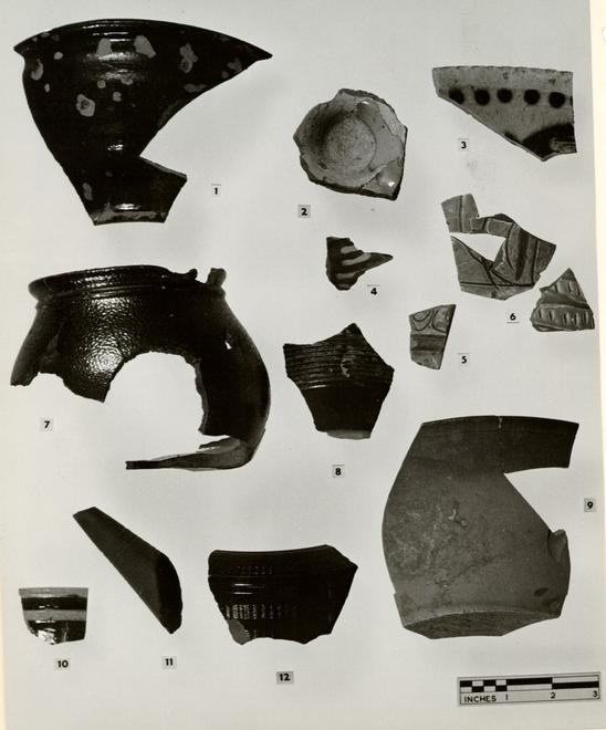 Fig. 34 Ceramics
Figure 34
- 1.Portion of a red-bodied, ochre-flecked, coarse earthenware funnel or cream separator of Tidewater origin, the whole covered with a lead glaze. The smaller opening has a pronounced everted rim, perhaps to secure a string by which a straining fabric could be held in place. Two similar but more shallow funnels were found at the Coke-Garrett site in a deposit with wine bottles dating between 1730-40 [2576. E.R. 140-27A and 2577. E.R. 140-27A].
Date of Deposit: post 1730.
[2575. E.R. 686E-11.E.] - 2.Base of a small bowl of red clay, the interior covered with a slip containing traces of copper, and then both interior and exterior dipped by the base in a clear lead glaze. The small footring has a cordon above it, from which the bowl spreads sharply outward. Two similar bowls were found at the site of the Gaol [750-27B and 751-27B]. It is possible that all were made in the Alexandria area.
Unstratified.
[2578. E.R. 718-11.E.] - 3.Rim sherd of a large bat-molded dish of buff, grit-tempered earthenware with notched rim, slipped
49
interior decorated with dots, and streaks of an iron-stained slip.
Date of Deposit: post 1750.
[2579. E.R. 683-11.E.] - 4.Small fragment of a dish of red earthenware, the interior decorated with dashes of a white slip and another of green containing copper, these covered with a clear lead glaze which was also applied to the exterior. American.
Unstratified.
[2580. E. R. 734-11.E.] - 5.Small fragment of a round dish or platter of red earthenware, the interior covered with a white slip through which a design has been incised; the exterior slipped but unglazed. The interior slip has been covered with a slightly amber lead glaze. There is a ridge at the junction of the marly and bowl. Made at Bideford in North Devon, England. It could be dated to the late c.17 on stylized grounds.1
Date of Deposit: post 1800
[2582. E. R. 666A-11.E.] - 6.Two fragments of a pitcher of grey-bodied, well-fired earthenware decorated on the exterior with a white slip through which a design has been incised. A
50
slightly amber glaze covers the exterior. Made at Bideford, North Devon, England. Context post c. 1720, style C 1650-1700.1
[2581. E.R. 668Y-11.E.] - 7.Pipkin of brown saltglaze stoneware with flat base, incurving sides and a small everted rim, below which is a cordon. There is a shallow spout, but the handle is missing. The vessel has been dipped in a ferruginous clay slip which has fired to a dark, rich brown. The nature of the clay and slip would suggest a Yorktown, Virginia origin for this piece. Similar pipkins were found at the Coke-Garrett site [2258. E.R. 140-27B] and at the Hay site [2583. E.R. 748, 195-28D] all in archaeological deposits of the second and third quarters.
Date of Deposit: post 1750.
[2584. E.R. 734, 734A, 734G-11.E.] - 8.Base fragment of vase or jar of brown saltglaze stoneware, the whole covered with a ferruginous slip which has fired to a chestnut brown. Above the flat base appears to be a plain zone. A product of the stoneware kilns of Nottingham, England.
Date of Deposit: post 1790.
[2719. E.R. 723A-11.E.] - 51
- 9.Section of flared bowl with flat base and plain rim made of a black-flecked grey stoneware, the whole covered with a smooth ferruginous slip which has fired to a pale ginger brown. Fragments of a similar bowl were found at the Travis House1 in a deposit made post 1785.
Date of Deposit: post 1820.
[2586. E.R. 689B-11.E.] - 10.Rim sherd of a bowl of grey Rhenish saltglaze stoneware, undecorated on the interior but decorated on the exterior, close to the rim, with a wide groove and a cordon, the former being cobalt-filled and below a plain band. Below the latter is another area decorated with incised lines, cobalt-filled and plain zones. Made in the Westerwald area of the Rhineland. A slightly smaller bowl of a similar character was found at the Anthony Hay site2 in a context post 1740.
Unstratified.
[2585. E.R. 701-11.E.] - 11.Straight tea or coffee pot spout of unglazed redware, decorated with a band of wavy engine turning.
Unstratified.
[2587. E.R. 695-11.E.] - 52
- 12.Rim and shoulder fragment of a cylindrical redware teapot with recessed collar for lid and sharply angled shoulders. The latter and the body are decorated with bands of wavy engine turning, the whole covered with a lead glaze.
Date of Deposit: post 1790.
[2588. E.R. 707H-11.E.]
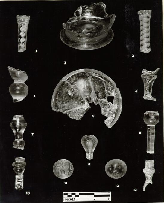 Fig. 35 Table and Pharmaceutical Glass
Figure 35
- 1.Straight stem of a wine glass with central opaque spiral and additional blue, green, and red threads. Date of Deposit: post 1790.
[2651. E.R. 717A-11.E.] - 2.Straight wine glass stem with gauze and multi-ply opaque twists.
Unstratified.
[2652. E.R. 667A-11.E.] - 3.Base of bowl (?) with folded pedestal foot and out-curving sides with expansion mold decoration of indeterminate design. There are similarities between this fragment and a tankard (or can) illustrated in English Glass, London, 1949, by W.A. Thorpe, Plate XVIII.
Unstratified.
[2653. E.R. 683-11.E.] - 4.Base of clear glass, round decanter (?).
Unstratified.
[2655. E.R. 695-11.E.] - 5.Solid inverted baluster from wine glass with flaring bowl.
Unstratified.
[2654. E.R. 683-11.E.] - 54
- 6.Fragment of small wine glass with quatrefoil stem and bowl attached directly to its top.
Unstratified.
[2663. E.R. 726-11.E.] - 7.Portion of stem of wine glass with upper angular knop containing a tear which is continued down to the stem, into a ball knop just above the foot. A similar glass appears in the Catalogue of the Circle of Glass Collectors, Commemorative Exhibition, 1937-1962, London, 1962, Pl, VIII, B, 1 where it is said to be "about 1700."
Date of Deposit: post 1830.
[2656. E.R. 727B-11.E.] - 8.Upper portion of straight stemmed wine glass with base of bowl solid except for single tear.
Date of Deposit: post 1740.
[2657. E.R. 668B-11.E.]* - 9.Inverted baluster stem with tear from wine glass.
Unstratified.
[2658. E.R. 725A-11.E] - 55
- 10.Portion of stem of wine glass consisting of a straight section topped by two flattened knops. Date of Deposit: post 1740.
[2659. E.R. 668B-11.E.]* - 11.Elaborately molded clear glass knop or finial with wrythen ribbing.
Date of Deposit: post 1790.
[2660. E.R. 723A-11.E.] - 12.Round top from clear glass decanter stopper with two circles of tears. A decanter with a similar stopper, illustrated in Country Life, CXXVII, No. 3323, November 10, 1960, page 1096, is engraved with a portrait of Prince Charles Edward. A stopper with identical arrangement and number of tears was found on the Anthony Hay site. [2664. E.R. 364B-28.D.]
Date of Deposit: post 1770.
[2661. E.R. 732G-11.E.] - 13.Neck of a clear glass perfume phial with flaring mouth and bulge, above a narrow body of uncertain form. Possibly American.
Unstratified.
[2662. E.R. 735-11.E.]
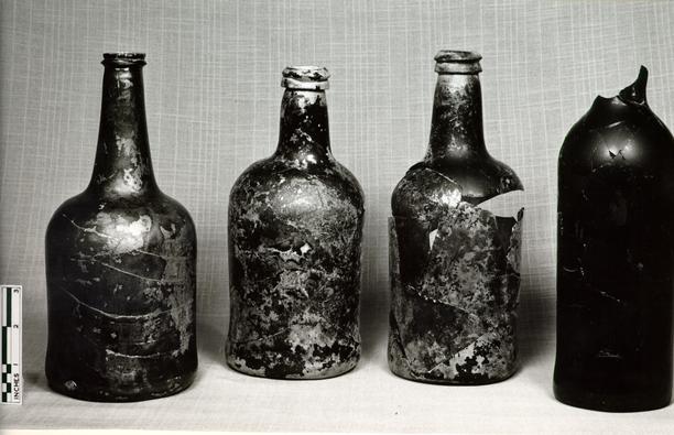 Fig. 36 Beverage Bottles
Figure 36
(left to right)
- 1.Cylindrical beverage bottle of pale olive green metal with down-tooled string-rim. Context post style 1750-1760.
Date of Deposit: post c.1760.
[2688. E.R. 734B-11.E.] - 2.Cylindrical beverage bottle of olive green metal with short convex profiled neck, conical basal kick and the lip and string-rim down-tooled. c.1790.
Date of Deposit: post 1800.
[2689. E.R. 673D-11.E] - 3.Cylindrical beverage bottle of pale olive green metal with short neck and down-tooled rim, and string-rim with tall conical basal kick.
Date of Deposit: post 1790.
[2690. E.R. 673D-11.E.] - 4.Body of tall cylindrical beverage bottle, mold made, with tall conical basal kick. The metal is amberolive green and somewhat bubbled.
Date of Deposit: post 1820.
[2691. E.R. 669C-11.E.]
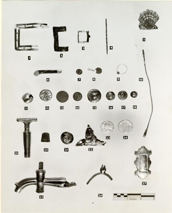 Fig. 37 Small finds
Figure 37
- 1.Portion of large brass shoe buckle, the two rectangles being separated by evenly spaced "beads."
Date of Deposit: post c.1770.
[2624. E.R. 695C-11.E.] - 2.Portion of rectangular shoe buckle, brass, possibly plated, with design of leaves enclosed by two grooves.
Date of Deposit: post 1740.
[2625. E.R. 668B-11.E.] - 3.Unfinished, untrimmed, and extremely crude small brass buckle, probably for a hat ribbon. This may have been a product of the metal-working operations of Captain Hugh Orr.
Unstratified.
[2626. E.R. 683-11.E.] - 4.Small rod of silver, twisted in the central section and beaten out to form a spatula at each end; probably a manicure or toilet instrument. No mark.
Date of Deposit: post 1790.
[2627. E.R. 716-11.E.] - 5.Brass hook with baluster shank tapering to its junction with the separately-made scallop shell
58
terminal. The iron spike or screw by which this hook was attached to the wall is missing.
Unstratified.
[2628. E.R. 730-11.E.] - 6.Small folding brass penknife, the blade missing as well as a portion of one of the bone plates which were attached to either side of the handle.
Unstratified.
[2629. E.R. 680-11.E.] - 7.Small, flat, round, pewter sleeve button, bearing a relief bust of Queen Anne, facing left, and surrounded by the inscription, "Anna Dei G." The outer edge is encircled by a very small beading on a narrow flange. The back is flat, and the loop is molded in one piece with the button. Possibly celebrating the coronation of Queen Anne.
Date of Deposit: post 1740.
[1973. E.R. 668B-11.E.] - 8.Octagonal brass cuff-link with original brass wire link. Owing to its poor condition it is impossible to see whether any decoration existed.
Date of Deposit: post 1780.
[2630. E.R. 690D-11.E.] - 9.Gold finger ring with silver-backed glass "stone" in a simple claw setting. No marks.
59 Unstratified.
[2631. E.R. 735A-11.E.] - 10.10. Brass spoke from an umbrella.
Date of Deposit: post 1810.
[2632. E.R. 679B-11.E.] - 11.Hollow, round, domed, brass button, undecorated and with two short lengths of rod braised on at right angles to each other by which it could be attached to cloth or leather.
Unstratified.
[2633. E.R. 679-11.E.] - 12.Round button with a bone back with four holes attached to a brass front with a stamped design of a flowering bush growing out of a rock. The button has a beaded edge (South type 3).1
Date of Deposit: post 1790.
[2634. E.R. 732D-11.E.] - 13.13. Round button, bone backed, with five holes and covered with brass impressed with a woven design (South type 3).1 Context post c.1840. Style, 18th century.
Date of Deposit: post 1840.
[2635. E.R. 704-11.E.] - 60
- 14.Small round button with bone back with four holes and brass front with embossed star motif and beaded edge (South type 3).1
Unstratified.
[2636. E.R. 690-11.E.] - 15.Convex brass button, undecorated (underside shown) with fragmentary loop (South type 7).1
Unstratified.
[2637. E.R. 691-11.E.] - 16.Flat brass button, undecorated, (underside shown) with fragmentary loop (South type 7).1
Date of Deposit: post 1790.
[2638. E.R. 681B-11.E.] - 17.Small, round, flat, brass button, undecorated, (underside shown) with machine stamped words, "Treble Gilt, Standard Colour" and folded brass loop (South type 18).1
Context post c.1790.
[2639. E.R. 691A-11.E.] - 18.Small, flat, brass button, undecorated, (underside shown) with raised seat for brass loop (South type 7).1
[Disintegrated during treatment] - 61
- 19Brass key for wine cock. The shaft has a figure-of-eight hole through it to permit the passage of liquid.
Unstratified.
[2641. E.R. 694C-11.E.] - 20.Brass thimble, thickened rim and convex cap. The body recesses are oval, while those on the cap are square and larger.
Date of Deposit: post 1840.
[2642. E.R. 704-11.E.] - 21.Round-headed copper rivet, possibly used for repairing domestic utensils and perhaps a relic of Captain Hugh Orr's metal-working. (See also this figure, Nos. 3 and 22).
Unstratified.
[2643. E.R. 679-11.E.] - 22.Two small pieces of thin sheet copper attached to each other at right angles with a single rivet and two other holes on the upper fragment. Perhaps a relic of Captain Hugh Orr's metal-working. (See also this figure Nos. 3 and 21, and Figure 38, No. 17).
Date of Deposit: post 1750.
[2644. E.R. 683E-11.E] - 62
- 23.Virginia halfpenny, copper, in good condition. Obverse, portrait of George III to right, legend, GEORGIUS III·REX. Reverse, arms of Virginia, crowned seven string harp, legend, Virginia: 1773.1 Issued 1775.
Date of Deposit: post 1780.
[2645. E.R. 711-11.E.] - 24.Irish halfpenny of George II. Obverse, old head to left, legend, GEORGIUS II·REX. Reverse, crowned harp with legend, HIBERNIA over and date, 1760 below.2
Unstratified.
[2646. E.R. 747-11.E.] - 25.Brass wine cock with projection beyond the spout against which bottles were held during filling. Filing marks are visible on the tapering after-section. This cock was operated by a hollow key of triangular section which fitted over the corresponding projection on the cock.
Date of Deposit: post 1770.
[2647.E.R. 665A-11.E.] - 63
- 26.Portion of small brass spur, probably child's, rowel missing for its pear-shaped projection.
Disturbed Deposit.
[2648. E.R. 690G-11.E.] - 27.Brass fitting, probably from harness, convex on front with a recessed rectangular convex panel. The underside originally had three prongs equally placed down the long axis of the fitting which, when bent over, secured it to leather. A similarly shaped but larger brass fitting was excavated at the Coke-Garrett House site [2650. E.R. 157D-27.A.] in association with objects of the period 1755-1765.
Date of Deposit: post 1780.
[2649. E.R. 690D-11.E.]
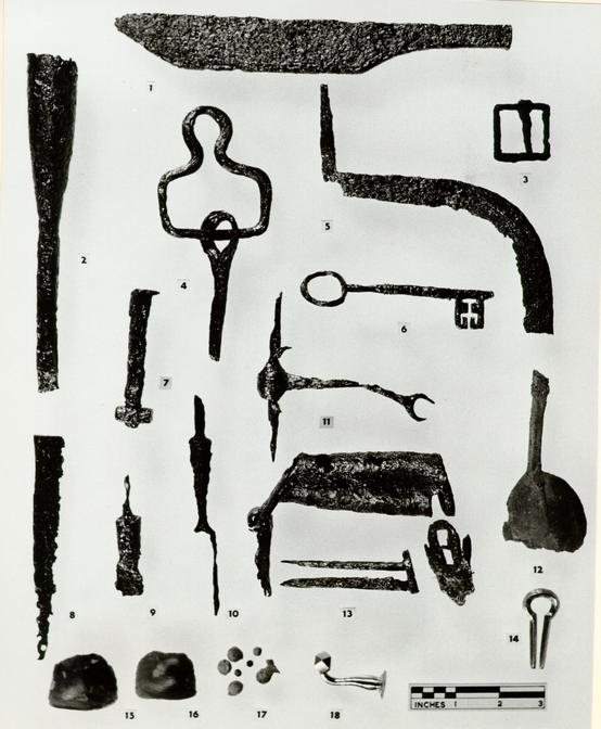 Fig. 38 Iron objects and small finds
Figure 38
- 1.Iron knife-like object with overall thickness of ¼" and no cutting edge. Possibly an oyster-opener. The handle is short and roughly finished.
Unstratified.
[2671. E.R. 694C-11.E.] - 2.Socketed mortising chisel bearing the stamped words, "CAST STEEL" and some further illegible letters.
Unstratified.
[2665. E.R. 691-11.E.] - 3.Small, square, iron harness buckle with square-sectioned tang. Similar buckles have been found on Virginian sites of all phases of the 18th century.
Unstratified.
[2670. E.R. 673-11.E.] - 4.Iron harness hook for wagon with fitting for strap attached.
Date of Deposit: post 1790.
[2678. E.R. 721A-11.E] - 5.Handle and lower portion of blade of sickle.
Date of Deposit: post 1790. [2672. E.R. 718A-11.E.] - 65
- 6.Small iron key with oval bow, stem ornamented with cordons and enlarged toward the collar of solid pin.
Date of Deposit: post 1790.
[2673. E.R. 687L-11.E.] - 7.Bolt with screw thread at end to which a square nut is attached. The head is incomplete.
Date of Deposit: post 1790.
[2674. E.R. 702A-11.E.] - 8.Blade tip of single-edged sword?
Date of Deposit: post 1780.
[2675. E.R. 690D-11.E.] - 9.Center section of iron table knife with round-sectioned solid shank and tang in poor condition. Only a small portion of the blade remains. A similar knife was found at the Anthony Hay site in a context of post c.1770 [2699. E.R. 256A-28.D].
Unstratified.
[2676. E.R. 673-11.E.] - 10.Fragment of iron two-tined table fork with octagonal shank and pointed tang.
Date of Deposit: post 1740.
[2677. E.R. 668M-11.E.] - 11.Fragment of iron snaffle bit in poor condition.
Disturbed Deposit.
[2680. E.R. 687B-11.E.] - 66
- 12.Fragment of pewter tablespoon with incomplete bowl and square-sectioned handle. There is a crude rattail .
Date of Deposit: post 1810.
[2681. E.R. 684E-11.E.] - 13.Three fragments of iron barrel-type lock from a shackle. Only a single spring remains burnished to the two-pronged section and most of the shackle itself is missing. A lock operating on similar principles but smaller and with decoration was lent to the Archaeological Laboratory by Mr. J.P. James of Williamsburg, and detailed photographs may be found in the files.
Date of Deposit: post 1810.
[2679.a,b,c, E.R. 696A-11.E.] - 14.Small brass Jew's Harp, the reed missing.
Unstratified.
[2682. E.R. 740-11.E.] - 15.Musket flint, dark grey in color, knapped in the Continental manner which produces a domed upper surface rather than the angled shape of the English flints. Probably Revolutionary style.
Date of Deposit: post 1730.
[2683. E.R. 727B-11.E.] - 67
- 16.Musket flint, grey in color, knapped in the Continental manner which produces a domed upper surface rather than the angled shape of the English flints. Style probably Revolutionary. Unstratified.
[2684. E.R. 735-11.E.] - 17.Small group of lead shot varying in diameter from 5/16" to 2/10". Larger balls are unfinished and it is likely, therefore, that they were made on or near the site.1
Date of Deposit: post 1740.
[2685. E.R. 668C-11.E.] - 18.Small brass hook with slight baluster on stem and octagonal knob. The iron shank or screw by which the hook was attached is missing. A hook with a similar finial was found at the Anthony Hay site in a context post 1775. [2687. E.R. 247C-28.D.] and another hook for a similar purpose is shown in Figure 37, No. 5.
Unstratified.
[2686. E.R. 691-11.E]
 Fig. 39 Determining the bore sizes of tobacco pipe stem fragments found in the Orr walkway.
The discovery of pipes with the same mark as the Prentis Store Site (E.R. 1417D-18C) suggests that the Orr fragments represent damaged goods discarded by the store, see Appendix II.
Footnotes
APPENDIX I
Table of brick sizes removed from Orr Site and preserved
| Location | Measurements | Color |
|---|---|---|
| S.W. corner of store | 8-½ x 4-¼ x 2-3/8" | rich red |
| 8-5/16 x 4-1/8 x 2-½" | rich red | |
| Path north of store | 8-¼ + x 4-1/8 x 2-3/8" | pale salmon |
| 8-½ x 4-½ x 2-½" | pale purple (with dog print) | |
| South foundation of Orr House | 8-¾ x 4-¼ x 2-½" | pale salmon |
| 9-1/8 x 4-¼ x 2-¾" | pale salmon | |
| Chimney of existing residence | 8-¾ x 4 x 2-¾" | pale salmon |
| 9 x 4 x 2-¾" | pale salmon | |
| North foundation of colonial kitchen | 9-1/8 x 4-1/8 x 2-5/8" | salmon |
| 9-¼ x 4-¼ x 2-¾" | salmon | |
| East foundation of colonial kitchen | 9-¼ x 4-3/8 x 2-13/16" | deep salmon |
| 9 x 4-¼ x 2-¾" | deep salmon | |
| Kitchen south extension foundation | 8 x 3-¾ x 3-¾" | deep salmon |
| 8-3/16 x 3-¾ x 2-¾" | deep salmon | |
| Bonded block, possibly from existing residence foundation and thrown aside when underpinned by C.W. | 8-¼ x 3-¾ x 2-¼" | purple |
| 7-3/8 x 3-½ x 2-¼" | rich red |
APPENDIX II
CLAY TOBACCO PIPE DATING IN THE LIGHT OF RECENT EXCAVATION1
by
Audrey Noël Hume
Since the publication in 1954 of Mr. J.C. Harrington's1 method of achieving dating from stem fragments of English clay tobacco pipes and its subsequent refining by Lewis E. Binford,2 archaeologists at Colonial Williamsburg have been endeavoring to evaluate its limitations and applications. This theory is based on the fact that as the stem lengths grew throughout the seventeenth and eighteenth centuries the diameter of the hole in the stem decreased. Mr. Binford worked out a mathematical formula which would provide a mean date rather than the wider period which could be ascertained from Mr. Harrington's chart.
During the last eight years Colonial Williamsburg has excavated a number of sites where groups of pipes have been found either in close association with datable ceramics or in a context whose date can be confirmed by documentary or historical evidence. One of the most significant of these was a walkway3 excavated in 1963 on the site of Captain Hugh Orr's Dwelling in Williamsburg. It was composed of over 12,000 fragments of clay tobacco pipes mixed with small pieces of window glass and a number of glass and ceramic items, all dating from the first half of the eighteenth century. The actual number of pipe fragments recovered from the walk itself was 11,164 while a further 932 were found in the back-filling of post holes subsequently cut through it. The Binford formula was applied to the main group at certain arbitrary intervals, as the gigantic task of washing the fragments progressed, to determine the number of fragments needed to arrive at the same mean date as that eventually established from the entire collection.4
| No. of Pipes | Date Provided by Formula |
|---|---|
| 290 | 1736.59 |
| 383 | 1737.74 |
| 1111 | 1740.55 |
| 1509 | 1740.17 |
| 4746 | 1741.71 |
| 9272 | 1740.55 |
| 11,164 | 1740.55 |
It will be seen from this table that when the one thousand mark was passed there was no variation from the result obtained on eleven times as many specimens. The other group comprising the back-filling of post holes subsequently dug through the walk provided the following statistics:
| Post Hole5 | A | 19 | 1726.38 |
| B | 35 | 1738.09 | |
| C | 51 | 1733.29 | |
| D | 62 | 1739.37 | |
| E | 129 | 1742.09 | |
| F | 295 | 1740.55 | |
| G | 341 | 1740.94 |
| No. of Pipes | Date Provided by Formula |
|---|---|
| 19 | 1726.38 |
| 54 | 1733.67 |
| 105 | 1733.29 |
| 167 | 1735.58 |
| 296 | 1738.26 |
| 591 | 1739.79 |
| 932 | 1740.55 |
Table number 4 (below) shows some of the other groups from Williamsburg and from Virginia to which the Binford formula was applied. They show an interesting pattern of diminishing accuracy with increasing date.
Four of these groups, known by archaeological and documentary evidence to date from the period 1760-1790, each yielding from 249 to 485 stem fragments, produced results at least twenty years too early. In the case of the one nineteenth century deposit tested (its date confirmed by the presence of coins of 1816 and 1817) the formula gave a date of 1751. Even the fairly large size of the group (168) made no difference to the accuracy of the result. However, of six well stratified deposits with known dates of the period 1690-1760, the formula provided a date well within the range. Of these groups, one contained only 17 pipes 71 and so should be distrusted, but in another case 91 pipes produced a dating of 1709 for the filling of a pit belonging to a house apparently abandoned when its owner went to North Carolina in 1708-1709.
| Site | No. | Binfold | Documentary or Archaeological |
|---|---|---|---|
| Rosewell, Glos. Co. Va. | 485 | 1747 | 1763-72 |
| Hay Site, Wmsbg, Group I | 290 | 1753 | 1770-80 |
| Hay Site, Wmsbg., Group II | 31 | 1759 | 1770-80 |
| Hay Site, Wmsbg., Group III | 72 | 1747 | 1775-80 |
| Post Office Site, Wmsbg. | 168 | 1751 | 1817-20 |
| Travis House, Wmsbg. | 51 | 1755 | 1775-90 |
| Coke-Garrett Site, Wmsbg. | 990 | 1759 | 1750-65 |
| Tutter's Neck Plantation, Va. | 91 | 1709 | 1702-10 |
| Clay Bank, Glos. Co. Va. | 648 | 1698 | 1690-1700 |
| Coke-Garrett, Wmsbg. (II) | 213 | 1767 | 1760-70 |
| Post Office Site, Wmsbg. (II) | 121 | 1758 | 1750-65 |
| Post Office Well, Wmsbg. | 17 | 1731 | 1725-35 |
| Coke-Garrett Gaol, Wmsbg. | 271 | 1751 | 1745-60 |
Not only did the fragments from the early eighteenth century walkway at Captain Orr's Dwelling in Williamsburg, shed light on the applications of the Harrington-Binford dating method, but the pipes also revealed some interesting facts about their makers. The total of tobacco pipe bowls from the Orr walkway numbered between 760 and 800, many of them being extremely fragmentary.
The bulk of the heeled and marked examples bore the molded initials RM astride the heel. Ninety-four of these fell into fourteen easily distinguishable groups but fifty-five were either incomplete, had been smudged by finger prints or were so poorly molded as to be illegible. It is possible, therefore, that these pipes represented some twenty different molds in use at the same time by "R.M."
Of the fourteen easily recognizable variations of the RM mark, two types contained a cross in relief at the interior base of the bowl. This was a total of nineteen pipes, or twelve percent of the total number of initialed bowls. A detailed examination of the larger of these groups, with eighteen pipes, showed that the tool with which the cross was applied always faced in the same direction indicating that perhaps it was in some way attached to the mold. An illustration in Diderot's Encyclopedia6 shows a conical plunger in position on a pipemaker's bench, but it is impossible to see if there is any grooving on the tip. From the same walkway came a group of heel-less pipes also with a cross inside the bowl, but careful scrutiny has revealed that the tool which applied this cross was not the one used on the heeled RM pipes. Of the 448 heel-less bowls present, only 84 or 10% had the crosses.
There were also a number of pipes bearing the initials WM in several forms, including examples molded on the base of a heel-less pipe, molded astride the heel, and molded astride the heel and surmounted by either crowns or sunbursts. Pipes bearing all of the latter markings are well known in Williamsburg though they are usually found in deposits of 1750-1765, at least ten years later than the apparent laying of the Orr walkway. Efforts to identify RM and WM have not been very successful even with Adrian Oswald's invaluable list of known tobacco pipe-makers in his paper "The Archaeology and Economic History of English Clay Tobacco Pipes."7 However, the list does indicate that a family, bearing the surname Meakin with members Randle and William, was working in Chester in the first half of the eighteenth century.8 As this town had close ties with the southern American colonies by reason of participation in the slave trade, it would not be surprising for pipes from there to be in use in Williamsburg.
The Orr walkway yielded a number of pipes of other makers. Most numerous were those marked AS; in some cases the mark was 73 placed astride the heel while in other instances it was placed at the base of a heel-less bowl. Other pipes bore the initials ID & DT (the D being in retrograde) or GT astride the heel.
Whether the entire collection represented debris from a tavern (a fact suggested by the presence among them of fragments of a number of ceramic tankards) or were the result of accidental breakage during shipping or storage is uncertain. If they represented a single consignment the presence of a number of different marks would seem to be unlikely. Unfortunately, the history of the Orr House around the period 1740-1743 is incomplete except to reveal that by the latter date there was a blacksmith's shop on the lot.
74As little traces of Middle Plantation have been found in Williamsburg excavations, there have been few opportunities to test seventeenth-century groups. But, Mr. Harrington's often stated reservation that his theory becomes invalid during the latter part of the eighteenth century has been amply demonstrated. On the other hand, the large assemblage from the Orr site, coupled with many other deposits from the first half of the century show that the Harrington-Binford formula can be of the greatest value to archaeologists working in this and earlier colonial periods.
APPENDIX III
Appraisement of Hugh Orr's estate
| 1 | Desk and Book case £ 10 - 1 bed and furniture £ 20 | 30/ 0/ 0 |
| 1 | Black Walnut Desk | 3/ 0/ 0 |
| 1 | Black Walnut Chest of Draws and cupboard | 3/10/ 0 |
| 1 | Tear Table and stand £ 1 - 1 carpett, 2 small looking glasses £ 3 | 4/ 0/ 0 |
| 1 | Easy Chair, 6 leather chairs, £ 5 - 9 Pictures | 5/10/ 0 |
| 1 | Pr. tongs, 1 shovel, 1 pr. and irons, 2 trivets, 1 pr. bellows | 0/12/ 6 |
| 1 | Silver watch £ 5, 2 cases with bottles | 6/10/ 0 |
| 1 | Warming pan 7/6- 4 rush bottom chairs 7/- 1 clock £ 10 | 10/14/ 6 |
| 2 | Walnut oval dining tables £ 4, 12 Walnut chairs £ 8 | 12/ 0/ 0 |
| 1 | small square tear table 30/- 1 square black walnut table 12/6 | 2/ 2/ 6 |
| 1 | large looking glass £ 3, 1 corner cupboard 10/ | 3/10/ 0 |
| 6 | Views with gilt frames £ 2-10, - 21 large prints and maps £ 5 | 7/10/ 0 |
| 1 | Brass fender, 1 pr. and irons, 1 pr. tongs, 1 shovel | 1/15/ 0 |
| 12 | China plates, 3 bowls, 1 ½ doz cups & saucers, 6 coffee cups) and saucers, 1 tea pot, 1 sugar pot, 6 custard cups | 4/ 2/ 6 |
| 7 | Earthern Dishes, 2 ½ doz. plates, 7 Rye Moulds, 3 wash basons) | |
| 3 | Punch strainers, 3 bowls, 8 mugs, 3 jugs, 11 flower pots, ( | |
| 1 | fruit basket, 1 tea pot, 1 sugar dish, 2 milk pots ) | 2/10/ 0 |
| 4 | Glass Pickling pots, 1 large Tumbler & top, 10 glass tumblers) | |
| 10 | Wine glasses, 1 glass bowl, 11 silver ——, 1 large soup) spoon, 1 silver tea pot ( | 29/15/ 0 |
| 1 | Cullender and 1 sugar box, 1 copper tea kettle | 0/12/ 6 |
| 1 | copper stew pan, 2 coffee pots | 1/ 0/ 0 |
| 2 | Coffee mills, 2 brass chafing dishes | 1/ 0/ 0 |
| 1 | box iron, 2 heaters, 1 plate warmer | 0/17/ 6 |
| 1 | Bed and furniture with curtains | 10/ 0/ 0 |
| 1 | Bed and furniture, 2 close stools and pans | 8/10/ 0 |
| 3 | small pine tables | 0/13/ 0 |
| 76 | ||
| 1 | bed and furniture with curtains | 10/ 0/ 0 |
| 4 | beds with furniture | 35/ 0/ 0 |
| 1 | pr. and irons, 1 pr. tongs and fender | 0/15/ 0 |
| 2 | pine tables, 1 bed with curtains | 10/12/ 6 |
| 2 | Beds with furniture, 1 saddle and furniture | 16/ 0/ 0 |
| 1 | Writing desk, 1 pewter bed pan, 2 large chests | 1/12/ 6 |
| 9 | old chains, a pine tables | 2/ 8/ 6 |
| 1 | large brasskettle, 3 Bell metal skillets | 3/ 0/ 0 |
| 2 | pr. flat irons, 1 small brass kettle | 1/ 0/ 0 |
| 1 | large mortar and Pestle, 5 iron pots | 3/ 0/ 0 |
| 3 | pot racks, 4 hooks, 2 frying pans, | 1/12/ 6 |
| 1 | Dutch oven, 1 jack and 2 spits | 3/10/ 0 |
| 1 | pr. kitchen and irons, 1 pr. tongs, 2 trivets Tubs and pails, 1 pr. silver mounted pistols | 6/ 5/ 0 |
| 1 | Silver mounted hanger, 2 guns | 10/ 0/ 0 |
| 1 | brass mounted —— 1 large smiths vice | 2/ 0/ 0 |
| 16 | Vols. of Magazines - 1 set of Spectators | 3/ 0/ 0 |
| 1 | Set of the Guardians - 4 Vols. of Dean Preadeau | 0/ 1/ 6 |
| 3 | Vols. on Farrier - 3 Vols. of The Free Thinker | 0/12/ 6 |
| 30 | Vols. of different kind, 1 large Bible | 3/ 0/ 0 |
| 1 | Vol. Bates Works - 13 Table Cloths | 5/ 0/ 0 |
| 18 | Pair Sheets, 12 Napkins, 35 Towels | 29/15/ 0 |
| 6 | large Jugs - 1 Carboy | 0/15/ 0 |
APPENDIX IV
| 1777 st | MRS. ORR Dr to takeing Down a Grate 2/6 —— £ | . 2. 6 |
| February 21 | ||
| October 29 | To 75 bricks 2/6, 5 bushs of lime 5/. layg a harth 2/6 & fixg Grate 7/6 | .17. 6 |
| 1778 April | 1. To mortare and mending oven 4/6 | 4. 6 |
| Octor | 2. To 1 bushel of whitewh 3/. pr [?] Joe. | 3. - |
| 1779 Septembr | 3. To 9 bushs of lime 9/. [illeg] & 2 ½ days labr a 2/6 | 12. 3 |
| To Repairing Plastering & larthing £7.0.0 th 22/6 | 1. 2. 6 | |
| Novembr | 19 To 3 bushs of lime 45/ - 200 bricks a 55/- | 8. - |
| To Repairing underpining to poarch & layg floor 90/- (6/.) | 6. - | |
| th To 1 Days labour 40/ —— 2/6 | 2. 6 | |
| 1781 March | 19 To 100 bricks 12/9. 2 bushs of lime 1/6 & mending aback 3/9 | 9. 6 |
| 1782 July | 30 To 8 bushs of lime ¼ & 125 bricks [illeg] Repairing well 28/. & 2 days labour 8/. | 2. 6.18 |
| (Setled with . George Reid — & is to Be paid by him) :£6.15. 1 |
| Mr George Ried. | Dr | ||
| 1782 | st | ||
| Novembr | 21 | To Cash paid you in part per account | £ 15 — |
| 1783 | 29 | 3* | |
| May | 10 | 3* 12 -* | |
| Augt | 10 | 3* 12 -* | |
| 26 | To 11 bushs of lime a 1/. & Rebuilding Store Steps 15/. | 1 6. - | |
| To 2 days labour a 3/. July 8th, to 435 [?], of Oats in the Straw a 6/. | 1 12. - | ||
| August | 27 | 1 10 -* | |
| Septemr | 8 | 1 10 -* | |
| Octor | 13 | 3* | |
| 1784 | |||
| January | 12 | 1 2. 6* | |
| 14 | 20. . -* | ||
| June | 7 | 4 17 6* | |
| 78 | |||
| 1785 | |||
| March | 15 | 7 ?* | |
| April | 27 | To 18 bushels of lime 19/. & building 2 pair) of steps, & cutting stone & repairing under-) pining. 22/6.. | 2 0 6 |
| To building up cellar door & cutting out a-) nother & working in Frame 20/. | 1. 0. - | ||
| To 5 days labour a 2/6 | 12 6 | ||
| May | 14 | To 10 bushels of lime at 1/. & building) 2 pair of steps, & repairing) underpining 15/) | 1. 5. - |
| th | To labour work 5/. | - 5. - | |
| June | 4 | To 1 bushel of lime 1/. & repairing Steps at Store door 3/. | - 4. -* |
| Octor | 18 | 3. | |
| 31 | To 2 bushels of lime 2/. & contracting Chimney 3/9 | 5. 9 | |
| To white-washing a Room 4/6 | - 4 6 | ||
| rd | |||
| Decr | 3 | To 2 bushels of lime 2/. & working up 2 Cellar windows 5/. | - 7 - |
| 1786 | |||
| July | 11 | To 15 bushels of lime 15/. & rebuilding front door steps 16/ | 1 11. - |
| To 125 bricks 3/9 & labourers work 2/6 | - 6. 3 | ||
| Novembr | 25 | To 30 bushels of lime 30/. & 1 do of hair 2/. & 8 days labr a 2/6 | 2 12 - |
| To Repairing Larthing & plastering for Wm Carter your Tenant 15/. | 15. - | ||
| To laying a harth 2/6. & Setting up a Grate 7/6 (for Ditto) | 10. - | ||
| To Fixing in a Stove, & [illeg] up the chimney 15/. (M. Pearson) [illeg] | 15. | ||
| To Repairing Larthing, & plastering 12/6 (for Ditto) | 12 6 | ||
| 1788 | To 18 bushels of lime for. (Store at M.P) | 18. | |
| Octor | 23 | 10 -* | |
| £66. 1. 7 | |||
E. Excepted for
W. Harwood Exor
See postea 34 vol. Led. C.
APPENDIX V
1814
Mutual Assurance Society Policy No. 405 of Robert Anderson January 18, 1814
"... My buildings on the Main Street now occupied by Wilson Cheeks situated between the main street on the north a cross street dividing the lot of charlton's on the east, Frances street on the south and on the west by Lightfoot's lot and the masons Hall in the county of York and James City
| The Dwelling marked | A at | $1200 |
| The Store House marked | B at | 150 |
| The Carriage house marked | D at | 75 |
| The Kitchen house | C at | 150 |
| The Stable house | E at | 100 |
| $1675 |
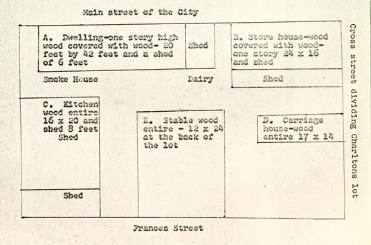
1823
Mutual Assurance Society Policy No. 5039 revaluation of buildings formerly declared for assurance by Robert Anderson per declaration No. 405
1823, April 8th
Edward Teagle residing at Williamsburg in the county of York do hereby declare for assurance my building on my own land situated between the lot of Lightfoots estate West and streets otherwise in the county of York and James City …
| The Dwelling house | marked A at | $1200 |
| The Store house marked | marked B at | 150 |
| The Kitchen house | marked C at | 140 |
| The Stable house | marked D at | 100 |
| $1590 |
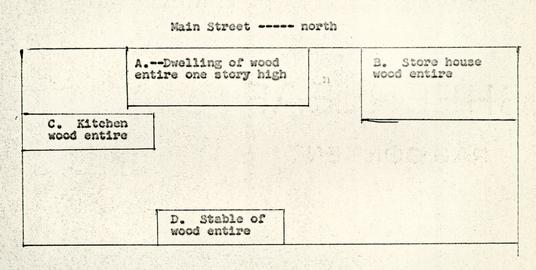
1830
Mutual Assurance Society Policy No. 7602 reval of buildings declared by Edward Teagle as per declaration No. 5039 1830, May 20th
That the said Buildings are at present owned by Edward Teagle and are occupied by his family residing at Williamsburg that they are situated on the main street in Williamsburg between Lightfoots lot on the west and streets otherwise
| The Dwelling | marked | A at | $1200 |
| The Store | marked | B at | 200 |
| The Kitchen | marked | C at | 150 |
| The Stable | marked | D at | 62.50 |
| $1612.50 |
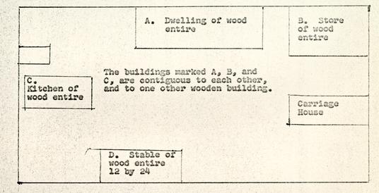
1839
Mutual Assurance Policy No. 11,017 reval of buildings declared by Edward Teagle as per declaration No. 7602 1839, April 24th
That the said building is at present owned by Edward Teagles heirs residing at Williamsburg and are occupied by John A. Deneufville residing at Williamsburg That they are situated on the main street in Williamsburg on the north, a cross street on the East, Francis street on the South and George Southalls lot on the West in the County of York & [illegible] City
| The Dwelling | marked | A at | $1000 |
| The Cabinet makers shop | B at | 200 | |
| The Kitchen | C at | 200 | |
| $1400 |
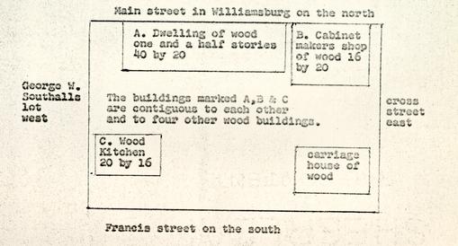
1846
October 3, 1846
Mutual Assurance Society Policy No 14386 revaluation of Buildings formerly declared for Assurance by Edward Teagles estate per Declaration No. 11017
I the underwritten John Deneufville residing at Williamsburg in the county of York do hereby declare for Assurance... My Buildings on my own land in Williamsburg now occupied by myself situated between the main street North, a cross street dividing it from a house and lot of Robert Anderson, East, Frances street on the South and William Peach's lot on the West in the county of York
| The Dwelling | marked | A at | $1000 |
| The Store | marked | B at | 300 |
| The Kitchen | marked | C at | 150 |
| $1450 |
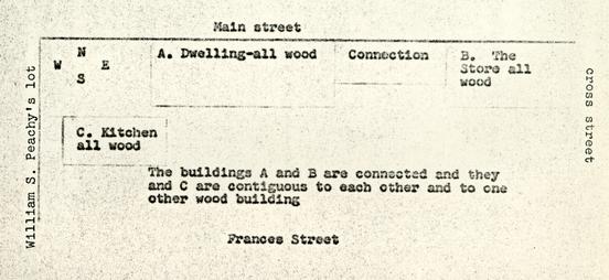
1853
November 1853
Mutual Assurance Policy No. 17630 revaluation of buildings formerly declared for Assurance by John Augustine Deneufville per Declaration No. 14386
I the underwritten John A. Deneufville residing at Williamsburg in the county of York do hereby declare for Assurance in the Mutual Assurance Society against Fire on Buildings...my Buildings on the Main Street now occupied by myself situated between the lot of William S. Peachy on the West, and streets otherwise in the county of York…
| The Dwelling | marked | A at | $1500 |
| The Store | marked | B at | 500 |
| The Kitchen | marked | C at | 150 |
| $2150 |
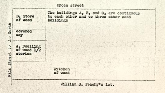
APPENDIX VI.A
Dating of Excavation Register Groups from the
Captain Orr's Dwelling Site
The following dating is based on the latest artifacts in each assemblage, and on this evidence, suggests the "throw away" date for the group or deposit. It must be understood that this is merely post quem dating and is subject to revision on the basis of associations between one group and another. It must also be borne in mind that many of the groups contain much that was manufactured and in use long before the final date suggested here.
| E.R. Group | Dating | E.R. Index Vol. V | |
|---|---|---|---|
| 661A | First quarter 19th century | 1 | |
| 661B | 18th century | 1 | |
| 661C | Colonial 18th century | 1 | |
| 661D | 18th century | 2 | |
| 661E | Unstratified | 2 | |
| 661F | 1725-1745 | 2 | |
| 661G | Unstratified | 2 | |
| 661H | 1790-1810 | 2 | |
| 661J | 1810-1830 | 2 | |
| 661K | Unstratified | 2 | |
| 661L | 1790-1810 | 2 | |
| 662 | Unstratified | 2 | |
| 86 | |||
| 662A | c.1770 | 2 | |
| 662B | 1770-1780 | 3 | |
| 663 | Unstratified | 3 | |
| 663A | c.1850 | 3 | |
| 663B | 1770-1780 | 4 | |
| 663C | Disturbed | 4 | |
| 663D | 18th century | 4 | |
| 663E | Late 19th century | 4 | |
| 663G | 1785-1795 | 4 | |
| 663H | 19th century | 4 | |
| 663J | 1780-1790 | 4 | |
| 663K | 1780-1790 | 4 | |
| 663L | 1770-1780 | 12 | |
| 663M | 19th century | 12 | |
| 663N | 1765-1775 | 12 | |
| 663P | 1785-1800 | 12 | |
| 663Q | 1770-1780 | 12 | |
| 663R | Second half 18th century | 12 | |
| 663S | Modern | 12 | |
| 664 | Topsoil | 5 | |
| 664A | 1790-1820 | 5 | |
| 664B | Mid 19th century | 5 | |
| 664C | Colonial | 5 | |
| 664D | Second half 18th century | 5 | |
| 87 | |||
| 664E | Modern | 5 | |
| 664F | 1810-1820 | 6 | |
| 664G | 1770-1780 | 7 | |
| 664H | 1740-1750 | 7 | |
| 664J | 1770-1780 | 11 | |
| 664K | 1770-1780 | 11 | |
| 664L | 1710-1730 | 10A | |
| 665 | Topsoil | 6 | |
| 665A | 1770-1780 | 6 | |
| 665B | 1785-1800 | 6 | |
| 665C | 1775-1790 | 6 | |
| 665D | 1770-1780 | 6 | |
| 665E | 1750-1770 | 8 | |
| 665F | No dating | 8 | |
| 665G | No dating | 8 | |
| 665H | Disturbed | 8 | |
| 665J | 1770-1790 | 8 | |
| 665K | 1770-1780 | 8 | |
| 666 | Topsoil | 7 | |
| 666A | 19th century | 7 | |
| 666B | First quarter 19th century | 7 | |
| 666C | 1790-1820 | 7 | |
| 666D | 1740-1780 | 7 | |
| 666E | 1770-1780 | 7 | |
| 667 | Topsoil | 9 | |
| 88 | |||
| 667A | Disturbed | 9 | |
| 667B | 1790-1810 | 9 | |
| 667C | Colonial | 9 | |
| 667D | 1770-1790 | 9 | |
| 667E | 1725-1745 | 10 | |
| 667F | 1790-1810 | 10 | |
| 667G | 1790-1810 | 10 | |
| 667H | 1790-1810 | 10 | |
| 667J | 18th century | 10 | |
| 667K | 1790-1810 | 10 | |
| 667L | Disturbed | 11 | |
| 667M | 1790-1810 | 11 | |
| 667N | 1790-1815 | 11 | |
| 668 | Topsoil | 14 | |
| 668A | c.1740-1745 | 14 | |
| 668B | 1740-1745 (with some intrusion c.1810) | 14 | |
| 668C | 1740-1745 | 14 | |
| 668E | Modern | 16 | |
| 668F | Disturbed | 16 | |
| 668G | Disturbed | 16 | |
| 668H | 1740-1745 Disturbed | 16 | |
| 668J | 1740-1745 Disturbed | 16 | |
| 668K | 1740-1745 Disturbed | 16 | |
| 668L | 1740-1745 Disturbed | 16 | |
| 89 | |||
| 668M | 1740-1745 Disturbed | 16 | |
| 668N | 1740-1745 Disturbed | 17 | |
| 668P | 1740-1745 Disturbed | 17 | |
| 668Q | 1740-1745 Disturbed | 17 | |
| 668R | Colonial | 17 | |
| 668S | Colonial with 19th century intrusions | 17 | |
| 668T | Topsoil | 17 | |
| 672 | Topsoil | 21 | |
| 672A | To early 19th century | 21 | |
| 672B | 19th century | 21 | |
| 672C | 1790-1810 | 21 | |
| 673 | Topsoil | 22 | |
| 673A | Disturbed | 22 | |
| 673B | 1790-1810 | 22 | |
| 673C | Disturbed | 22 | |
| 673D | 1790-1810 | 22 | |
| 673E | 1820-1830 | 22 | |
| 673F | 1790-1810 | 23 | |
| 673G | 19th century | 23 | |
| 673H | Colonial | 23 | |
| 673J | To 1820 | 23 | |
| 673K | Colonial | 23 | |
| 673L | Modern | 23 | |
| 674 | Modern | 23 | |
| 90 | |||
| 675 | 1790-1810 | 24 | |
| 675A | 1730-1740 | 24 | |
| 676 | Disturbed | 24 | |
| 677 | Topsoil | 24 | |
| 677A | To 1830 | 24 | |
| 677B | Mid 19th century | 24 | |
| 678 | Topsoil | 24 | |
| 678A | Colonial | 24 | |
| 678B | To 1850 Disturbed | 25 | |
| 679 | Topsoil | 27 | |
| 679A | To 1820 | 27 | |
| 679B | To 1810 | 27 | |
| 679C | To 1810 | 27 | |
| 679D | To 1800 | 27 | |
| 679E | 1770-1790 | 27 | |
| 679F | Disturbed | 28 | |
| 679G | 1780-1800 | 28 | |
| 680 | Topsoil | 28 | |
| 680A | 1780-1800 | 28 | |
| 681 | Topsoil | 29 | |
| 681A | To 1830 | 29 | |
| 681B | 1790-1800 | 29 | |
| 681C | Disturbed | 29 | |
| 682 | Topsoil | 30 | |
| 682A | Modern | 30 | |
| 91 | |||
| 682B | 1725-1750 | 30 | |
| 682C | 1775 | 30 | |
| 682D | To 1810 | 30 | |
| 682E | 1730-1770 | 30 | |
| 683 | Topsoil | 32 | |
| 683A | 1785-1795 | 32 | |
| 683B | Disturbed | 32 | |
| 683C | Colonial | 32 | |
| 683D | 1700-1750 | 32 | |
| 683E | 1750-1775 | 33 | |
| 683F | c.1810 | 33 | |
| 683G | Colonial | 33 | |
| 684 | Topsoil | 33 | |
| 684A | 1810-1820 | 33 | |
| 684B | Mid 18th century | 35 | |
| 684C | Mid 18th century | 35 | |
| 684D | 1730-1750 | 35 | |
| 684E | To 1810 | 35 | |
| 685 | Topsoil | 36 | |
| 685A | Colonial | 36 | |
| 685B | 1780-1800 | 36 | |
| 685C | Colonial | 36 | |
| 685D | Uncertain | 36 | |
| 685E | Post 1853 | 36 | |
| 685F | c.1750 | 37 | |
| 92 | |||
| 686 | Topsoil | 39 | |
| 686A | To 1840 | 39 | |
| 686B | Modern | 39 | |
| 686C | Modern | 39 | |
| 686D | Modern | 39 | |
| 686E | 1730-1740 | 39 | |
| 686F | Colonial | 39 | |
| 686G | 1770-1780 | 39 | |
| 686H | 1780-1800 | 40 | |
| 686J | 1730-1740 | 40 | |
| 686K | Colonial | 41 | |
| 686L | 1882 | 44 | |
| 686M | 1780-1790 | 65 | |
| 686N | 1780-1800 | 65 | |
| 686P | Colonial | 65 | |
| 686Q | Second quarter 18th century | 65 | |
| 686R | Second quarter 18th century | 65 | |
| 686S | Second quarter 18th century | 65 | |
| 686T | First quarter 18th century | 66 | |
| 686V | No dating | 66 | |
| 687 | Topsoil | 41 | |
| 687A | Disturbed | 41 | |
| 687B | To 1810 Disturbed | 41 | |
| 687C | c.1790 | 41 | |
| 687D | Colonial | 41 | |
| 93 | |||
| 687E | c.1790 | 41 | |
| 687F | 1800-1810 | 41 | |
| 687G | To mid 19th century | 42 | |
| 687H | To 1840 | 42 | |
| 687J | c.1790 | 43 | |
| 687K | c.1790 | 43 | |
| 687L | c.1790 | 44 | |
| 687M | 1800-1810 | 44 | |
| 687N | To 1800 | 44 | |
| 687P | To 1850 | 44 | |
| 688 | Topsoil | 47 | |
| 688A | To 1810 | 47 | |
| 688B | 1800-1810 | 47 | |
| 688C | Mid 18th century | 47 | |
| 689 | Topsoil | 48 | |
| 689A | 1810-1820 | 48 | |
| 689B | To 1820 | 48 | |
| 689C | Disturbed | 48 | |
| 689D | Mid 18th century | 48 | |
| 689E | Mid 18th century one intrusive | 48 | |
| 689F | Disturbed | 48 | |
| 689G | Mid 18th century | 49 | |
| 689H | Colonial | 49 | |
| 689J | 1770-1790 | 49 | |
| 94 | |||
| 689K | c.1820 | 49 | |
| 689L | 1725-1750 | 49 | |
| 690 | Topsoil | 50 | |
| 690A | 1820-1830 | 50 | |
| 690B | 1770-1780 | 50 | |
| 690C | 1790-1800 | 50 | |
| 690D | 1780-1790 | 51 | |
| 690E | 1780-1790 | 52 | |
| 690F | Post 1780 | 52 | |
| 690G | To 1850 | 52 | |
| 691 | Topsoil | 53 | |
| 691A | 1790-1810 | 53 | |
| 691B | 1770-1780 | 53 | |
| 691C | Modern | 53 | |
| 691D | 1770-1790 | 53 | |
| 691E | 1740-1750 Disturbed | 53 | |
| 691F | 1740-1750 Disturbed | 53 | |
| 691G | 1780-1790 | 54 | |
| 691H | Colonial | 54 | |
| 692 | 1790-1810 | 54 | |
| 693 | Topsoil | 54 | |
| 693A | Disturbed | 54 | |
| 693B | Disturbed | 54 | |
| 693C | To 1815 | 54 | |
| 693D | No dating | 54 | |
| 95 | |||
| 693E | 1740-1750 | 56 | |
| 694 | Topsoil | 56 | |
| 694A | Disturbed | 56 | |
| 694B | Disturbed | 56 | |
| 694C | Disturbed | 56 | |
| 694D | No dating | 56 | |
| 694E | 1770-1780 | 103 | |
| 694F | No dating, post 1810 | 103 | |
| 694G | No dating, post 1810 | 103 | |
| 694H | No dating, post 1810 | 103 | |
| 694J | 1790-1810 | 103 | |
| 694K | Colonial | 103 | |
| 695 | Topsoil | 59 | |
| 695A | Modern | 59 | |
| 695B | Modern | 59 | |
| 695C | 1770-1780 | 59 | |
| 695D | No finds | 59 | |
| 695E | 1820-1830 | 60 | |
| 696 | Topsoil | 60 | |
| 696A | To 1810 | 60 | |
| 697 | Topsoil | 60 | |
| 698 | Topsoil | 60 | |
| 699A | Disturbed | 62 | |
| 699B | Disturbed | 62 | |
| 96 | |||
| 700 | Topsoil | 62 | |
| 700A | Disturbed | 63 | |
| 700B | c.1800 | 63 | |
| 700C | Disturbed | 63 | |
| 701 | Disturbed | 63 | |
| 701A | 1780-1790 | 63 | |
| 701B | To 1730 | 63 | |
| 701C | Colonial | 63 | |
| 701D | Colonial | 63 | |
| 701E | c.1790 | 63 | |
| 701F | Post 1775 | 63 | |
| 702 | Modern | 67 | |
| 702A | 1790-1800 | 67 | |
| 702B | 1780-1790 | 67 | |
| 702C | 1770-1790 | 67 | |
| 703A | Brick samples | 67 | |
| 703B | Brick samples | 67 | |
| 703C | Brick samples | 67 | |
| 704 | To 1840 | 68 | |
| 704A | To 1820 | 69 | |
| 705 | Topsoil | 69 | |
| 706 | Topsoil | 69 | |
| 707 | To 1800 | 69 | |
| 707B | c.1790 | 69 | |
| 97 | |||
| 707c | c.1790 | 70 | |
| 707D | c.1790 | 70 | |
| 707E | To c.1740 | 70 | |
| 707F | Topsoil | 70 | |
| 707G | Disturbed | 70 | |
| 707H | 1790-1810 | 70 | |
| 707J | To 1820 | 70 | |
| 707K | 1710-1740 | 97 | |
| 708 | Topsoil | 71 | |
| 708A | To 1825 | 71 | |
| 709 | Topsoil | 72 | |
| 709A | To 1815 | 72 | |
| 710 | Topsoil | 72 | |
| 710A | Disturbed | 72 | |
| 710B | 1790-1810 | 72 | |
| 710C | No dating | 72 | |
| 711 | 1780-1790 | 72 | |
| 711A | 1780-1790 | 73 | |
| 711B | 1780-1790 | 73 | |
| 711C | 1780-1790 | 73 | |
| 711D | Colonial | 75 | |
| 712 | 1780-1790 | 73 | |
| 712A | Modern | 73 | |
| 713 | To 1800 | 74 | |
| 98 | |||
| 714 | 1780-1790 | 74 | |
| 714A | Disturbed | 75 | |
| 715 | Disturbed | 74 | |
| 715A | Colonial | 75 | |
| 716 | 1790-1800 | 75 | |
| 716A | Colonial | 75 | |
| 716B | c.1800 | 75 | |
| 717 | Topsoil | 77 | |
| 717A | 1790-1810 | 77 | |
| 718 | Topsoil | 77 | |
| 718A | 1790-1810 | 77 | |
| 718B | 19th century disturbance | 77 | |
| 718C | 1780-1790 | 77 | |
| 719 | Topsoil | 77 | |
| 719A | No dating | 77 | |
| 719B | 1780-1790 | 77 | |
| 720 | Colonial | 77 | |
| 721A | 1790-1810 | 78 | |
| 722 | Topsoil | 78 | |
| 722A | 1790-1810 | 78 | |
| 722B | 1790-1810 | 78 | |
| 723 | Topsoil | 80 | |
| 723A | 1790-1810 | 80 | |
| 723B | To 1830 | 80 | |
| 99 | |||
| 724 | Topsoil | 80 | |
| 724A | 1790-1810 | 80 | |
| 724B | 1780-1790 | 81 | |
| 724C | 1775-1790 | 81 | |
| 725 | Topsoil | 81 | |
| 725A | 1790-1810 | 81 | |
| 725B | 1770-1780 | 81 | |
| 726 | Topsoil | 83 | |
| 726A | c.1830-1840 | 83 | |
| 727 | Topsoil | 83 | |
| 727A | 1830-1840 | 83 | |
| 727B | 1830-1840 | 83 | |
| 728 | Topsoil | 84 | |
| 728A | 1830-1840 | 84 | |
| 728B | 1830-1840 | 84 | |
| 728C | 1830-1840 | 84 | |
| 728D | Disturbed | 84 | |
| 729 | Topsoil | 84 | |
| 729A | 1830-1840 | 85 | |
| 729B | 1740-1760 | 85 | |
| 729C | To 1820 | 85 | |
| 730 | Topsoil | 86 | |
| 731 | Topsoil | 86 | |
| 731A | Colonial | 86 | |
| 731B | 1770-1790 | 86 | |
| 100 | |||
| 731C | 1780-1800 | 86 | |
| 732 | Topsoil | 88 | |
| 732A | 1790-1810 | 89 | |
| 732B | 1740-1770 | 89 | |
| 732C | To 1820 | 89 | |
| 732D | 1790-1810 | 89 | |
| 732E | 1790-1810 | 89 | |
| 732F | Colonial | 89 | |
| 732G | 1770-1780 | 89 | |
| 732H | Colonial | 90 | |
| 732J | 1810-1830 | 90 | |
| 732K | 1810-1820 | 90 | |
| 732L | 1810-1830 | 90 | |
| 733 | Topsoil | 90 | |
| 733A | To 1830, Disturbed | 90 | |
| 733B | 1790-1810 | 90 | |
| 733C | 1780-1800 | 92 | |
| 734 | Topsoil | 92 | |
| 734A | 1770-1790 | 92 | |
| 734B | 1750-1765 | 92 | |
| 734C | To 1725 | 92 | |
| 734D | Colonial | 92 | |
| 734E | Late 19th century | 93 | |
| 734F | To 1810 | 93 | |
| 734G | Mid 18th century | 93 | |
| 101 | |||
| 734H | Second quarter 18th century | 93 | |
| 734J | Modern | 93 | |
| 735 | Topsoil | 94 | |
| 735A | Disturbed | 94 | |
| 735B | First half 18th century | 94 | |
| 735C | Disturbed | 94 | |
| 735D | 1820-1840 | 94 | |
| 735E | Disturbed | 94 | |
| 735F | To 1800 | 95 | |
| 735G | No dating | 95 | |
| 735H | To 1825 | 95 | |
| 735J | Disturbed | 95 | |
| 735K | Disturbed | 95 | |
| 735L | Modern | 95 | |
| 735M | Disturbed | 95 | |
| 735N | Modern | 96 | |
| 736 | Topsoil | 96 | |
| 736A | To 1800 | 96 | |
| 736B | Mid 19th century | 96 | |
| 737 | Disturbed | 97 | |
| 738A | Disturbed | 98 | |
| 738B | Disturbed | 98 | |
| 738C | Disturbed | 98 | |
| 738D | Disturbed | 98 | |
| 738E | c.1820 | 98 | |
| 102 | |||
| 738F | Disturbed | 99 | |
| 738G | Disturbed | 99 | |
| 738H | Disturbed | 99 | |
| 738J | Disturbed | 99 | |
| 738K | Disturbed | 99 | |
| 738L | Disturbed | 99 | |
| 738M | Disturbed | 99 | |
| 738N | Disturbed | 99 | |
| 738P | Disturbed | 99 | |
| 738Q | Second quarter 19th century | 99 | |
| 738R | Disturbed | 99 | |
| 738S | Disturbed | 99 | |
| 738T | Disturbed | 99 | |
| 738V | Disturbed | 99 | |
| 738W | Disturbed | 99 | |
| 738X | Disturbed | 104 | |
| 738Y | Colonial | 104 | |
| 739 | Topsoil | 100 | |
| 739A | To 1875 | 100 | |
| 739B | To 1850 | 101 | |
| 739C | To 1820 | 101 | |
| 740 | Topsoil | 101 | |
| 741 | Topsoil | 104 | |
| 741A | Disturbed | 104 | |
| 741B | Disturbed | 104 | |
| 103 | |||
| 741C | Disturbed | 104 | |
| 742 | Topsoil | 104 | |
| 742A | Post 1800 | 104 | |
| 742B | 19th century | 104 | |
| 743 | Topsoil | 105 | |
| 743A | 18th century | 105 | |
| 744 | Topsoil | 105 | |
| 744A | 1790-1820 | 105 | |
| 744B | 1780-1810 | 105 | |
| 745 | Topsoil | 106 | |
| 745A | No dating | 106 | |
| 745B | Disturbed | 106 | |
| 745C | Disturbed | 106 | |
| 745D | Topsoil | 106 | |
| 745E | To 1820 | 106 | |
| 745F | Topsoil | 106 | |
| 745G | Disturbed | 106 | |
| 745H | To 1830 | 106 | |
| 745J | 1830-1840 | 107 | |
| 745K | Topsoil | 107 | |
| 745L | 1820-1840 | 107 | |
| 745M | 1830-1850 | 107 | |
| 745N | Topsoil | 107 | |
| 745P | Disturbed | 107 | |
| 745Q | To 1810 | 107 | |
| 104 | |||
| 745S | Disturbed | 107 | |
| 745T | Disturbed | 107 | |
| 746 | To 1825 | 108 | |
| 746A | 19th century | 108 | |
| 746B | 19th century | 108 | |
| 747 | 19th century | 109 | |
APPENDIX VI.B
Summary of Excavation Register Numbers
663N. Post hole sealed beneath floor of carriage house and predating building. Colonial lot line. Finds include delft bowl with fish ("Wincanton") motif, also good quality saltglaze jug base. Also present, overglaze creamware fragment. c.1765-1775.
665A. Bottom of topsoil and top of brown soil level with some rubble (as E.R. 664B). Note presence of brass wine cock, also unusual saltglaze pattern.
666A. Disturbed nineteenth century or later soil under thin scatter of brick rubble to east. (Note presence of first Bideford slipware sherd found in Williamsburg).
667A. Disturbed brown soil over entire area, but dipping towards the south, immediately beneath and blending into topsoil. Note fragment of paving tile and red roofing tile.
668B. Paved area made from broken pipes and window glass with a much smaller quantity of pottery.
106669C. Post hole against north face of area filled with broken bottles dating into the 1820's or later.
673 Area excavation at rear of shop site immediately east of Orr residence. Topsoil.
673C. Light brown soil over natural and disturbed by modern utility cuttings, area west of south foundations.
673D. Group of broken wine bottles immediately south of shop south foundation and partially lying over edge of wall line. c.1800. 1'2" below modern grade.
679 Area excavation north of well. Topsoil down to paved area as removed by 1928 excavations. Finds include buttons, lead bullet, wine glass stem, etc. Note presence of clay flooring tiles similar to those from the Byrd lot, Travis lot, Post Office site.
679B. Large hole, partially filled with washed sand cutting into north edge of brick wall. Finds colonial with one fragment of creamware. Note fragment of umbrella, lead ball, and iron slag 107 present. Floor 2-½" - 3" in thickness at 8" - 9" below modern grade. This area was somewhat disturbed as it extended into the excavation area, caused by the destruction of the shed beneath which it had been protected. Other late 18th century shreds may have found their way into the top of the paving during its life.
668C. 2" of brown soil below paving and thickly mixed with pipes and glass from it.
668D. Brown soil continuing 8" below path to natural. In some instances, containing material from 668C.
668M. Large post hole cutting through pipe and glass floor at north and containing same material. Slightly disturbed at top.
668Y. Scrapings on natural immediately inside and seemingly predating "store" at south edge of area, but certainly with some disturbance from 673D. Finds include fragments of rare West of England (Bideford) sgraffito jug, the first found in Williamsburg. Bottle fragments mainly first quarter of 18th century.
108680. Extension of area 679 south to the rebuilt well head foundation. Topsoil. Note presence of lead bale seal and small lead bullet. This layer extends to top of mutilated paving uncovered in 1928.
681B. Brown soil immediately under marl spread. Creamware and Rouen faience present. c.1780? Note presence of Worcester sherd and iron table fork. Considerable slag present.
682. Area excavation A1, south of Orr dwelling, measuring 14'5" x 10'0". Topsoil down to paving and brick drain, as replaced in 1928. Note presence of Bow porcelain and shark's tooth.
682C. Brick rubble under thin spread of marl at southwest corner of excavation. Much slag present and one fragment of creamware, remainder of finds second quarter of the 18th century. Note delft plate crossmend between 682B and C.
682D. Layer of bones and bats, probably part of 682B in same area extending to red and yellow clay layer.
109683. Area excavation A2 west of 682. Topsoil over-lying brick path replaced in 1928. Note presence of early inverted baluster glass, moulded bowl, and bulbous wig curler.
683E. Inner filling of large circular hole outside northeast corner of kitchen, with outer clay fill passing beneath both wall ? and path. Finds include slag and mid-18th century miscellaneous sherds, also brass waste.
684A. Scatter of brick rubble and ash at southeast corner of area* beneath topsoil. Largely mid-18th century with a few early 19th century intrusions. * This stratum continued across the area east of the kitchen with occasional disturbances.
684E. Rectangular post hole east of 684D, terminating at 3'2" below modern grade. Finds up to c.1810. Note presence of broken pewter spoon.
686E. Large circular hole 1'8" below modern grade containing an iron hoop at its bottom. Outside diameter of hoop 2'1", width 1-¾". Finds all 18th century, including a bowl of polychrome delftware with piecrust edge, coarseware "funnel" of Yorktown type, and numerous pieces of emerald-green bottle glass (rectangular).
110687B. Under topsoil of balk B1-C1, over deposit of iron. Possibly disturbed.
687J. Spread of brown soil immediately over channel or trough of burnt clay and ash. Finds all 18th century up to c.1750. Including sherds of good saltglaze jug. Note presence of Jew's harp. This group from balk between areas B1 and B2.
687L. 2" of dirty yellow clay under 687K and over burnt ash-flecked clay. Finds not all colonial. Depth 9" to 11", below modern grade.
689B. Layer of brown soil (4") under 6" of topsoil over area C2 outside kitchen foundation. Finds up to c.1820. Note presence of brown transfer-printed ware plate rim similar to sherd from the Travis House and Post Office Site 15.B. Also present, sherd of pierced creamware fish strainer (?), other sherds in 689.
689D. Rectangular post hole terminating at 3'9" below modern grade. Finds mid-18th century.
689G. Square post hole south of E.R. 689D, terminating 2'0" below modern grade. Finds up to mid-18th century. Note fragment of used crucible.
111689H. Small post hole terminating at 2'7" below modern grade. West of England sherds therein as in 689D, 689G.
689J. Post hole at southeast corner of kitchen "shed." Finds up to c.1770-1780. Hole terminates at 2'9" below modern grade.
690. Area excavation immediately south of Orr dwelling porch within limits imposed by present brick walks. Topsoil.
690D. Brickbats and dirty clay in top filling of robber trench, note presence of flooring tiles as at Post Office site, also fragment of iron fireback. No intact bricks and little loose mortar, suggesting fill derived from residue of cleaned bricks. Note oval sleeve-link, pipe stems, lead shot and harness ornament, also Rouen sherd giving terminus post quem of c.1780.
690G. Possible planting hole beyond southwest corner of robber trench and cutting through brick rubble spread in that area. Note presence of quantity of ferric slag at bottom with fragment of furnace?, also heavy brass spur fragment. Finds up to mid-19th century.
112691. Area excavation east of Orr dwelling south porch. Topsoil. Note presence of pierced creamware and shark's tooth, also octagonal brass hook.
691A. Brown soil with brick rubble over plaster layer 691B. Finds up to early 19th century. Note "S A" pipe fragment.
694C. Outside kitchen chimney on brick rubble, note brass wine cock and heavy iron blade, also Westerwald crossmend to 694B.
695. Area excavation southwest of well. Topsoil.
695C. Bottom of 695B, finds largely 18th century but possibly coming from earlier post hole found beneath. Note presence of large shoe buckle fragment and unidentified hooked iron item. Subsequent finds from post hole at bottom of hole show 19th century artifacts present.
696A. Test cutting under remains of marl and brick walk. Note presence of much iron slag. Finds up to 1810. Grey soil, no obvious stratification extending to natural.
701. Removal of brick walk running east-west between areas A1 and 2 and E.R. 690. Brown soil under brick walk.
113702A. Brown soil beneath brick-edged marl path running north-northwest/south-southeast. Finds up to late 18th century.
704. Finds from beneath marl spread and over layer of shells and brickbats, 3" brown dirt. Objects include two-piece, bone-backed button and brass thimble. Note transfer-printed Worcester porcelain, hand-painted and transfer-printed wares present dating up to c.1820. Note also [sickle] blade and unusual iron pintle or incomplete handle.
707H. Soil similar to 707G, [dark, ash-flecked soil under topsoil] but objects from beneath foundation of existing smokehouse and therefore of key dating significance. Objects include wine bottle fragments, snuff bottle, engine turned teapot, pearlware. c.1790-1810. Extending to 3" above natural.
707J. Post hole? extending under northeast corner of existing smokehouse.
711. Robbed wall trench as 690, but section in front of porch of existing house. Brick rubble layer as 690D. Virginia halfpenny of 1773 found at 9" below surface of old porch foundation. Creamware present.
114715. Disturbed (1928) fill of balk overlying southeast corner of kitchen foundation. Coin of 1773 resting on wall.
716. Scraping of destruction layer beside and overlying northwest robbed corner of foundation west of well. Note presence of silver manicure tool directly against foundation (north face). Finds up to c.1790 or 1810.
717A. Brick rubble and oyster spread of yard paving. Finds mixed into level and deposited contemporaneously. Note presence of creamware, late scratch blue and one sherd of shell-edged pearlware. Fine polychrome wine glass stem present. Deposit not before c.1785.
718. Area excavation north of 717A, topsoil.
718A. As 717A, yard metalling continuing northward. Note presence of Rouen faience, slag in bottom of spread.
721A. Oyster shell and brickbat layer as E.R. 717A and 718A, part of yard spread immediately west and northwest of well and sealed beneath late brick drain and marl spread to west of it. Note presence of creamware and Rouen faience.
115723A. Oyster shell and brickbat spread similar to that of 717A, 718A, 721A. Finds up to c.1790 with one or two late intrusions. Note presence of sherd from delftware "fish" bowl, Rouen faience, and elaborately molded glass knob or finial.
725A. Layer of dark loam mixed with ash, as 707G. Finds up to c.1790-1800.
726. (not shown on plan) Area Al, see above. Topsoil. Note presence of quatrefoil wine glass stem and good brass shoe buckle. Note this area disturbed to natural.
727B. (not shown on plan) Bottom scraping over natural. Note French gun flint and good ballustroid wine glass stem.
730. (not shown on plan) 3' test trench north-south through east side of orchard. Topsoil. Disturbed to bottom and previously cross-trenched east-west and north-south. Note presence of ornamental brass hook? in form of scallop shell.
732. Topsoil over entire dairy area and beneath existing kitchen building, approximately 6" of loose black dirt. Note presence of pearlware artist's palette cup.
116732D. As 732A [rubble yard layer passing beneath south-west corner of dairy foundation] extending inside dairy area. Note presence of fine bone-backed button found inside southwest corner of dairy.
732E. Planting hole southeast of dairy. Note presence of transfer-printed creamware sherd as E.R. 673C at the rear of shop site, also 723.
732G. 5-½" soft brown silt below 732F. One very small sherd of creamware present. Note presence of wine glass stem and teardrop knob.
734. Arbitrary area excavation north of 733. Topsoil.
734A. Scrapings over natural as 733A. Note presence of slag, green glazed (interior) "Spanish" jar sherds, also Yorktown stoneware pipkin. Finds up to c.1780 plus one sherd of blue-edged pearlware. Note decorated saltglaze.
734B. Large post hole? immediately west of north-south wall fragment. Containing complete bottle (its extraction recorded on 16mm. color film). Good ceramic range up to c.1760. Pit predating foundation? A quantity of large slag lumps were recovered from dirty clay at the bottom of this hole.
117734G. Large square cut and flat bottomed hole inside kitchen and almost certainly predating it. Note presence of "Spanish" jar and Yorktown pipkin sherd. Up to mid-18th century? Terminates at 2'0" into natural or 3'4" below modern grade.
735. Small area excavation initially dug by R. Muzzrole of the Smithsonian. Topsoil, also in continuation southwest of smokehouse.
735A. Brown loam beneath scatter of oyster shells immediately west of smokehouse, same as 707E? Disturbed by planting hole in 19th century so group not sealed. Note presence of gold ring.
738B. (not shown on plan) Second cross trench west of above. Disturbed [738A - First cross trench northeast/ southwest east of north-south path through orchard and west of north-south test cut. E.R. 730]
740. North-south balk between areas C1 & C2, topsoil over barrel hoop pit. Note presence of brass jew's harp.
747. (not shown on plan) Irish halfpenny found in back-filling cross trenches in orchard. Trench no. 2.
APPENDIX VII
KEY TO FIGURES 2 - 8
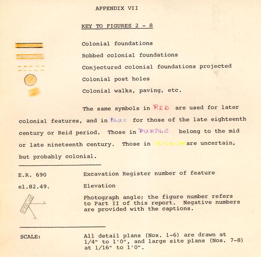 KEY TO FIGURES 2-8
- Colonial foundations
- Robbed colonial foundations
- Conjectured colonial foundations projected
- Colonial post holes
- Colonial walks, paving, etc.
The same symbols in RED are used for later colonial features, and in BLUE for those of the late eighteenth century or Reid period. Those in PURPLE belong to the mid or late nineteenth century. Those in are uncertain, but probably colonial.
E.R. 690 Excavation Register number of feature
el.82.49. Elevation
Photograph angle; the figure number refers to Part II of this report. Negative numbers are provided with the captions.
SCALE: All detail plans (Nos. 1-6) are drawn at ¼" to 1'0", and large site plans (Nos. 7-8) at 1/16" to 1'0".
APPENDIX VIII
Photograph Negative Numbers
| Figure 1 | 63-GR-651-10 |
| Figure 9 | 63-GR-651-3 |
| Figure 10 | 69-INH-1495 |
| Figure 11 | 69-INH-1493 |
| Figure 12 | 69-INH-1487 |
| Figure 13 | 69-INH-1478 |
| Figure 14 | 69-INH-1477 |
| Figure 15 | 69-INH-1479 |
| Figure 16 | 69-INH-1490 |
| Figure 17 | 69-INH-1492 |
| Figure 18 | 63-GR-229-3 |
| Figure 19 | 69-INH-1491 |
| Figure 20 | 63-GR-651-5 |
| Figure 21 | 69-INH-1484 |
| Figure 22 | 63-GR-651-2 |
| Figure 23 | 69-INH-1486 |
| Figure 24 | 69-INH-1488 |
| Figure 25 | 69-INH-1482 |
| Figure 26 | 69-INH-1481 |
| Figure 27 | 69-INH-1485 |
| Figure 28 | 69-INH-1489 |
| Figure 29 | 69-INH-1480 |
| Figure 30 | 69-INH-1483 |
| Figure 31 | 69-INH-1494 |
| Figure 32 | 63-GR-1221-1 |
| Figure 33 | 63-GR-1221-6 |
| Figure 34 | 63-GR-1221-4 |
| Figure 35 | 63-GR-1221-2 |
| Figure 36 | 63-GR-1221-5 |
| Figure 37 | 63-GR-1221-7 |
| Figure 38 | 63-GR-1221-3 |
| Figure 39 | 63-GR-376 |