Bryan House and Lot - Block 14, Building 15A (Archaeological Area B)17th Century Foundation Under Nassau Street (Block 14 - Archaeological Area B-2)
Colonial Williamsburg Foundation Library Research Report Series - 1296
Colonial Williamsburg Foundation Library
Williamsburg, Virginia
1990
Archaeological Report
BRYAN HOUSE AND LOT
BLOCK 14, BUILDING 15A
(Archaeological Area B)
Including Archaeological Report17TH CENTURY FOUNDATION UNDER NASSAU STREET
(Block 14, Archaeological Area B-2)
CHRONOLOGICAL SUMMARY
Based on report of Department of Research and Record "Block Fourteen Lots", which includes a portion of "Bryan Lot, Block 14, No. 351", dated October 10, 1940.
| 1781 or 1782 | Frenchman's map shows main house and three outbuildings behind it. |
| 1790 | Unknown Draftsman's map shows Bryan lot as No. 351. |
| 1795 | This lot transferred from John Lewis' estate to William Bryan. |
| 1797 to 1817 | Listed as "William Bryan's Est." in Williamsburg land tax records. |
| 1800 | Bucktrout map shows Bryan lot in same place as on unknown Draftsman's map. |
| Feb. 26,1810 | Property revalued for insurance - |
| ....We have viewed and revalued the building heretofore declared for assurance by William Bryan then residing at Williamsburg in the county of James City… We also certify that the said building is now owned by Frances Bryan and Julian Bryan that it is now occupied by Frances Bryan and that it is situated south of the main street East of Durfeys lot north of Coles lot and west of a cross Street dividing Coles lots. (Policy No. 1011, p. 11) (Research Report, Bryan Lot, B1. 14. No. 351, p. 1) | |
| See also diagram of property on insurance policy No. 1011 of this date. | |
| July 5, 1815 | Frances Bryan declares the house for insurance: |
| Frances Bryan, widow of William Bryan and guardian of Julian Bryan residing at Williamsburg in the county of James City do hereby declare for assurance ....... building on the main street in Williamsburg now occupied by myself situated between Coles lot, south and Durfeys lot west in the County of James City. (Policy No. 1511, p. 12., July 5, 1815) (Research Report, Bryan Lot, B1. 14. No. 351, p. 3) | |
| See also insurance policy No. 1511 of this date. | |
| 1818 to between 1825-1830 | Listed as owned by Jesse Cole in Williamsburg land tax records. |
| -3- | |
| 1830 to 1861 | Listed as owned by John W. Hutchings in Williamsburg land tax records. |
GENERAL AND DETAILED DESCRIPTION
AREA B. BLOCK 14
(BRYAN LOT)
by James M. Knight
This lot is rectangular in shape with an area of one-half acre located in the northeast corner of what is know known as Block 14. It is bounded on the north by the Duke of Gloucester Street and on the east by Nassau Street. Its present terrain is practically flat, although there appears to have been originally a slight slope to the south, towards the head of a ravine, which still runs east and west through the center of the Taliaferro-Cole lot. Archaeological investigation of the Bryan lot started October 15, 1940. N-6553.
A - BRYAN HOUSE
Considerable fill and debris were removed from the northeast corner of this lot and exposed what appeared to have been the site of a modern as well as a colonial building1. After carefully removing all of the fill, the remains of an 18th century building foundation, with basement, were exposed. It was set back approximately 5' from the Duke of Gloucester Street line and 4'-8" from the Nassau Street line. The dimensions of this foundation were 18'-3/8" by 32'-0" with a 14'-3-¾" addition on the west end. An insurance plat made February 26, 1810 indicates a 46' x 18' dwelling on this site which corresponds almost exactly to the foundation uncovered 2. At the east end of this foundation were the remains of an inside chimney which may have accommodated a basement fireplace, although no evidence of ashes was found.N-6532 The remains of an outside chimney were found on the west end of the later addition, but there was no evidence of a basement fireplace having existed. N-6533.
-5-Fragmentary remains of basement steps were found on the north side of this addition. The basement steps to the original, or east portion appear to have been on the west end, but were done away with when the west addition was added. Only the remains of the opening itself were found and served as a basement doorway between the original and the later portion. No indication of the front entrance to the first floor was found, although there were slight indications of a rear porch or steps on the south side. The average wall thickness of the foundation was 13-3/S" although in some places it was slightly more or less than this, which was caused by the thickness of the mortar joint. No evidence of floor paving was found anywhere in the basement. Several modern brick piers and walls were found, which were the remains of a modern store building razed in 1933.
| Brick size | - 8-7/8" x 4-¼" x 2-7/8" |
| Color | -Red |
| Bond | -English |
| Mortar | -Oyster shell |
| Condition | -Fair |
B - SEVENTEENTH CENTURY FOUNDATION
Four feet from the southeast corner of the Bryan house were discovered the remains of a 17th century foundation which evidently existed before Williamsburg was layed out as a town. It may be safe to say that this comprises the remains of a Middle Plantation dwelling since it is not in relation to any colonial city street lines and the eastern half lies under Nassau Street. A separate report covering this excavation entitled "17th Century Foundation, Block 14, Area B-2" is attached to this report. See archaeological drawing Block 14, Area B-2.
C - WELL
Twenty-seven feet south of the Bryan house were located the remains of the only well found in this lot. Its diameter was 4'-O". Fill composed -6- of yellow clay was taken out to a depth of 6' without finding any indications of brickwork. Probably the brick lining was salvaged before the well was backfilled with what may have been clay from some other well excavation nearby as portions of this fill very obviously were brought up from deep in the ground.
D - SMOKEHOUSE
Approximately 43' south of the west end of the Bryan house foundation were found the fragmentary remains of what was originally the Smokehouse. Only several short sections of the foundation existed to indicate the site of the north and west walls. A layer of wood ashes was found which is usually common when smokehouse foundations are uncovered. A thin layer of brick and mortar fill was exposed to the south, which showed strong evidence of being the south wall. This being true would indicate that this was an 8' x 8' building. The insurance plat of February 26, 1810 shows a smokehouse in this location which corresponds very closely to the location where this foundation was found.
| Brick size | - 8-¾" x 4" x 2-¾" |
| Color | - Red and buff |
| Bond | - English |
| Mortar | - Shell |
| Condition | - Bad |
E - KITCHEN
(See Architectural Report for notes on identification)
The remains of the kitchen foundation were found 60', more or less, south of the Bryan house, and 21-8-¾" west of the present Nassau Street line. This was the site of a modern garage which was demolished in 1933 so that much of the 18th century brickwork was destroyed. The southeast and southwest corners of the foundation were found and proved to have been originally a building 16'-½" in width. Portions of a 5' inside fireplace, -7- including several square feet of brick underfire paving, were located on the south end 3. N-6534. No foundation wall on the north end was discovered, although by careful digging a fill of crushed brick and shell mortar was found. This indicated the location of what was the north wall and proved that the kitchen was approximately 20' in length.
| Brick size | - 8-½" x 4" x 2-¾" |
| Color | - Red |
| Bond | - English |
| Mortar | - Oyster shell |
| Condition | - Bad |
F - PRIVY
(See Architectural Report for notes on identification)
A fill composed mostly of earth was removed from an area located 15' south of the kitchen. No brickwork whatsoever was found, although two slight depressions and a streak of black earth running north and south were exposed. A few fragments of 18th century china and glass were discovered, but nothing to prove definitely what originally existed here. The Frenchman's map of 1782 shows a building here which is probably where a privy may have been located.
H - STABLE
(See Architectural Report on Bryan Kitchen and Outbuildings for naming this structure)
In the southeast corner of this lot, only a few feet north of the existing colored church, were found the foundations of the stable. Only about half of this foundation existed and proved to have originally been a 28'-0" x 24'-0" building. The main or southern portion of this building was evidently 24'-0" x 18'-0" with a 9'-0" Lean-to or shed on the north. Much of this foundation was constructed of bats and broken bricks with a thickness of 8½" to 9". According to the Frenchman's map of 1782, a building was located on this site during the latter part of the 18th century 4.
-8-| Brick size | - 8½" x 4" x 2-¾" |
| Color | - Red |
| Mortar | - Shell |
| Bond | - English |
| Condition | - Poor |
ANCIENT POST HOLES
(See Plot Plan on Archaeological Drawing B1. 14, Area B)
(Also see Landscape Report for added information)
Approximately 120', more or less, west of the present Nassau Street line, but not exactly parallel with it, were discovered the remains of an old fence line. A line of holes, containing fill, ran almost exactly south from Duke of Gloucester Street for a distance of 121'. At this point it turned and ran approximately west for a distance of 76'. These two fence lines are evidently those shown on the Frenchman's map and the first course mentioned was thought to be the dividing line between the Bryan lot and the one just west of it. Finding these post holes proved that this was a colonial lot line. If the north side of Block 14 is divided into four equal parts or lots as shown on the Bucktrout and Unknown Draftsman's maps, it will place one of these divisions along the line of the post holes that runs north and south.
Shown on the Frenchman's map is a separate enclosure in the southwest corner of the Bryan lot. This enclosure extends well over on the lot to the west and forms what appears to have been a rectangular yard. Some of the older citizens of Williamsburg remember a graveyard being in this area which was proven true in 1934 when a deep trench for a sewer line was dug across the southern end of these lots. The remains of several skeletons were exposed during the digging operations, but no record was kept as to the exact location of the graves or condition they were in. When this area was explored during the archaeological investigation in 1940, several fills containing top soil were exposed, but complete investigation was not carried out because of added expense.
ARCHAEOLOGICAL REPORT
AREA B-2, BLOCK 14
(17TH CENTURY FOUNDATION UNDER NASSAU ST.)
By James M. Knight
During the archaeological investigation of the Bryan lot in October, 1940, the foundation of a very early colonial building was discovered. This foundation was only four feet from the southeast corner of the Bryan house foundation, lying partly in Nassau Street and partly in the Bryan lot, N-6553. Only the portion in the Bryan lot was excavated in October, 1940 because of the impracticability of closing and barricading Nassau Street at this time. N-6531. In April, 1942 permission was granted to barricade a part of the street for the purpose of further investigation of this foundation. This work was done at once and the area backfilled as soon as all available data was secured5.
The foundation was of a 43'-7" x 19'-4" brick building determined by the wall thickness and large amount of broken brick and shell mortar which composed practically all of the basement fill. It had a full basement with the western half paved with well preserved brick. N-6531. No evidence of brick paving in the eastern half was discovered. There was an inside chimney on each end, but only the one on the east appeared to have had a basement fireplace. N-6884, 6885. This was proven by a layer of wood ashes as well as the brickwork in the back and sides of the underfire being burnt. No indication of fire ever having existed in the western chimney was discovered so that the chimney above was held on a relieving arch. This end probably did not have a fireplace other than on the first and second floors. It is to be noted that the foundations of these chimneys do not center in the building, but are slightly to the south of the center line. (See Archaeological drawing, B1. 14, Area B-2)
Entrance steps to the basement were located on the east end near the northeast corner. N-6885. Several bricks which were remains of the -10- bottom tread and a strip of shell mortar which showed the imprint of the wood nosing were exposed. All other evidence of the steps had been destroyed.
The wall thickness of this foundation ranged from 18½" to 19", with the bottom course acting as a 22" spread footing. N-6882. Very few whole bricks were used in the interior of the wall. It seems that in order to utilize the bats and broken bricks, these were used as fillers for the inside of the wall while the whole bricks were used on the exterior face. (See section A-A on Archaeological drawing, also N-6883)
No evidence of outside steps to the first floor could be found on either the north or south side of the building. These were probably destroyed when the building was demolished and all traces of them have since disappeared.
| Brick size | - 9" x 4" x 2½" |
| Color | - Light reddish buff |
| Bond | - English |
| Mortar | -Oyster Shell |
| Condition | - Fair |
The artifacts found in the basement fill were composed mostly of broken ale bottles and pieces of lead came. The ale bottles were of the early colonial variety, very similar to those found at Jamestown, Virginia. Practically all of the lead carves were found in two locations within the basement. In the central portion of the paved area were found almost the complete remains of the leadwork of an early leaded glass window lying flat on the paving. There were also many broken pieces of window glass which originally formed small rectangular and diamond shaped panes. This window has been restored aid will be placed in the Old Courthouse Museum. About five pounds of lead cames were found in the extreme southeast corner of the basement, but in so damaged and distorted a condition that it was impossible to restore original shapes or sash sizes. Several pieces of broken clay pipe were also discovered among the debris of brick and mortar. Very few pieces of broken china or earthenware were found, and from the -11- general appearance, it seems that this basement was cleared of all contents or rubbish before the building was demolished.
At the present writing there is no known record of anything having been on this site in the 17th century. Thus it is impossible to state what this dwelling was or facts in regard to its early owners 6.
The foundations of the building are not parallel or perpendicular to any of the colonial Williamsburg street lines as it faced either north-northwest or south-southeast.
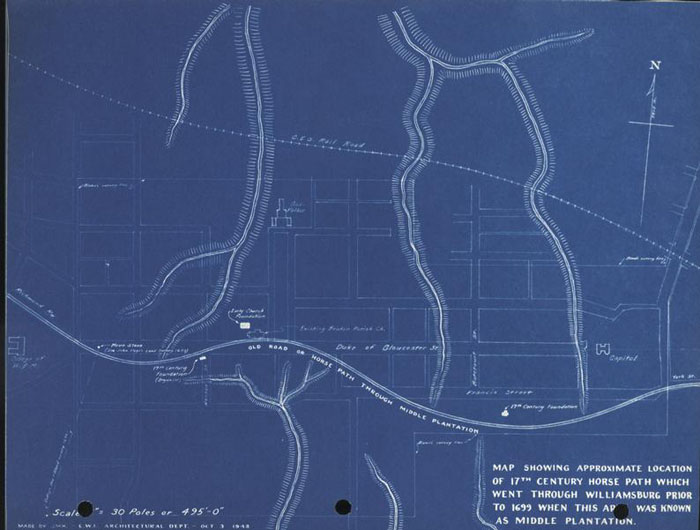
In the 17th century when the early settlers first began to inhabit Williamsburg., then known as Middle Plantation, they built a road along the peninsula which was known as "the horse path". This traveled ray followed the high ground between the ravines that drained to the York and James rivers. The drainage to the south side of the road flowed to the James river, while that on the north flowed to the York. If this road were again layed out along this ridge, the 17th century foundation in question would be on the south side and practically parallel to it, the north-northwest side of the building being the front. The early church foundations which were uncovered in Bruton churchyard in the summer of 1938 Would have been jest to the north of the road as it wound eastward. See attached plan showing the "horse path", etc.
SOURCES
- 1.Copies Incorporated Herewith
- a.Archaeological drawing "Survey of Foundations on Bryan Lot, Block 14, Area B".
- b.Archaeological drawing "Survey of Foundation of 17th Century House Located dust Southeast of Bryan House, Block 14, Area B-2".
- c.Plan showing "horse path".
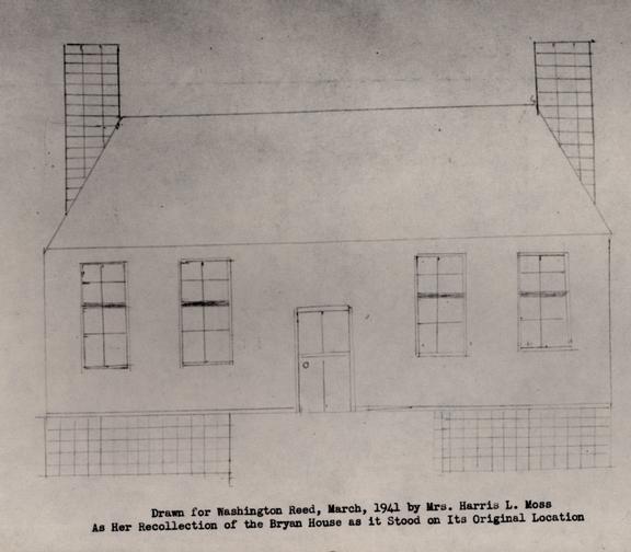
- d.Drawing to no scale by Mrs. Harris L. Moss as her recollection of the Bryan House as it stood on its original location.
- e.Memorandum to files by S. P. Moorehead, dated January 22, 1941 re: Miss Claudia Brooks information that Mrs. S. D. Scott, Jr. owned a photograph of the Bryan House after it was moved to Nassau Street from its original location.
- f.Memorandum to files by F. F. Ferguson dated March 3, 1941 recording his interview with Mrs. S. Dale Scott of Norfolk, Virginia. This report includes a "List of Facts Gathered from Looking at a Photograph of Bryan House, Block 14" .
- g.Memorandum to files from Washington Reed, Jr. dated March 4, 1941 recording his interview with Mrs. Harris L. Moss who lived in the Bryan House and who drew the sketch itemized under "C".
- h.Memorandum to files from E. M. Frank, dated March 5, 1941 recording the interview he and S. P. Moorehead had with Mr. W. C. Johnston in Petersburg, Virginia. Mr. Johnston lived in the Bryan House and recalled it very well.
- i.Letter from Mr. Johnston to S. P. Moorehead dated March 11, 1941 stating added facts about the Bryan House.
- j.Letter from S. P. Moorehead to Mr. W. C. Johnston dated March 26, 1941 acknowledging receipt of photograph.
- k.Memorandum to files by S. P. Moorehead dated March 26, 1941 recording an interview with Julian Van Fossen of Williamsburg about his father's photograph collection.
- 2.Copies in Architectural Department Files
- a.Research Report "Block 14 Lots".
- b.Frenchman's Map.
- c.Bucktrout, Bucktrout-Lively, Unknown Draftsman's maps, also Brown-Galt map.
- d.Two Rochambeau maps of Williamsburg.
- -13-
- e.Photograph of Millington water color of 1834 showing Bryan House, N-5997.
- f.Enlarged photograph of bird's-eye view of western part of the Duke of Gloucester Street taken from a high point at the main building at the College of William and Mary looking east, N-501.
- g.Architectural Report by E. M. Frank.
- h.Architectural Report on Bryan Kitchen and Outbuildings by E. M. Frank.
- i.Photographs showing foundations as excavated - N-6531, N-6532, N-6533, N-6534, N-6553, N-6882, N-6883, N-6884, N-6885.
- j.Johnston photograph showing house after being moved from original location, N-6616.
- k.Buildings on site in December, 1931, N-1825, N-1826. See also illustrations in small photographic property albums made by Todd and Brown, Inc.
- 3.In Department of Research and Record Files
- a.York County Records.
- b.Virginia Gazette.
- c.Williamsburg land tax records and transfers.
- d.Insurance policies.
- e.Charles, Lee, Vandergrift Recollections.
- f.Miscellaneous Records.
- g.See also a summary of all source material generally applicable to a typical report on a colonial Williamsburg building and lot.
- 4.In General Files
- a.Miscellaneous correspondence inquiring for information on the house and lot. Considerable routine office correspondence and communications with architectural and landscape consultants.
- 5.Fragments
- a.a. Boxes have been numbered according to area of origin and have been turned in to the Archaeological Laboratory and storage at the warehouse. Apart from the usual fragments of glass, pottery, chinaware and metal of ordinary domestic character see notes under general and detailed description for unusual artifacts.
NOTES
January 22, 1941
To: Files
From: S. P. Moorehead
Re: Bryan's House
Block 14 East
Today Miss Claudia Brooks came to my office with information concerning the above noted building which she remembers as it was after having been moved south into the lot from the original foundations (which were recently uncovered) and before it was demolished.
She told me Mrs. S. B. Scott, Jr., who formerly lived in this house has a photograph of it in its second position. Although we have written Mrs. Scott, it appears her address has been changed recently. Miss Brooks said she also has written Mrs. Scott asking if she would send her this picture. Miss Brooks further said she would contact us when and if she received it. In the meantime we have again written Mrs. Scott at her correct address.
S. P. M.
15.19
March 3, 1941
To: Files
From: F. F. Ferguson
Re: Interview with Mrs. S. Dale Scott, Norfolk, Va.
Concerning the Bryan House, Block 14.
At Mr. Kendrew's and Mr. Moorehead's request, I went to Norfolk on Saturday, March 1, and arranged to interview Mrs. S. Dale Scott, Jr., who, we had been told, had a photograph of the Bryan House in Block 14 here in Williamsburg. Mr. Moorehead had previously called Mrs. Scott and she had told him that it would be convenient to see one of our representatives some time during the weekend, and that she did have a picture of this house which we would be interested in. She was reluctant to send it to us. However, she said we could come to look at it. I took with me notes outlining information which would be of most assistance in accurately designing this house for its reconstruction.
I called Mrs. Scott when I arrived in town, and she said that she would be glad to meet me at about eight o'clock Saturday night at her house.
Her husband was present at the interview and asked me first what the Restoration would be prepared to pay for the photograph. I told him that at this time the Restoration was probably not prepared to pay anything, and that most people had been glad to lend us any photographs or give us any information that they had in their possession, which would assist us in the restoring of old houses. Mrs. Scott then got out the photograph and I showed her the sketches that I had brought. She looked at them and compared them with the photograph. I then began to question her about many details of the house which she might remember and took notes of them as she answered.
At this point Mr. Scott said that he thought if we wanted any information from the picture, we should buy it from them. Mrs. Scott said that she would be willing to lend it to us, but he said no, not without a check for $100.
I then told Mr. and Mrs. Scott that looking at old pictures was the only way that we could sometimes get adequate information on houses, the details of which were otherwise unknown. They both said that they understood this.
I continued to ask Mrs. Scott questions about the house. She gave me some information in regard to the inside stairway and hall, but seemed rather vague about the rear elevation and gabled ends of the house. She did say, however, she remembered the dormer which fell outside the limits of the photograph, which we were looking at, as being centered over a window below. She hesitated and seemed uncertain as to whether the house, when she lived in it, faced on Nassau or Duke of Gloucester Street.
Mr. Scott then intimated that the photograph would be valueless to them if I took any more information from it. I asked Mrs. Scott a few more questions, and suggested that the picture was not complete enough to be of great value to us, and asked again if they would lend it to us so that we could have a photograph made from it. They both refused and said they would like to have me discuss further with Mr. Kendrew as to whether the Restoration would care to purchase the picture. Mrs. Scott said, as I left, in regard to our buying the picture, that if she heard from us, all right, and if she didn't it would be all right.
I then left and made a free-hand sketch from my memory of the photograph, and wrote up notes of my talk with Mr. and Mrs. Scott and the information gathered from looking at the photograph. A copy of the notes is attached herewith.
Mrs. Scott had suggested before I left that we might obtain further information as to the details and plan of the house from her father, Mr. W. C. Johnston of Petersburg, editor of the "Progress Index".
I called Mrs. Scott again on Sunday and asked her if she could possibly remember whether the house was on its original site at the time she lived in it. She replied that she did not remember whether the house had then been moved to face Nassau Street instead of the Duke of Gloucester Street.
I finally asked her if she could possibly see her way clear to lend us the picture. She hesitated but said no, and added that she thought her father would be of help to us if we would get in touch with him in regard to any other details, and pointed out that she was only a girl of fourteen when she left the house.
I gained the distinct impression that Mrs. Scott was definitely inclined to be cooperative to the extent of giving or lending us the snapshot. However, her husband was very insistent about reimbursement and interjected his opinion constantly on this point throughout the whole conference.
I gathered that the snapshot is a personal belonging of Mrs. Scott because she got it out and showed it to me herself, and not her husband, to whom I had been talking before she entered the room.
F. F. F.
FFF.19
Att. - 2
copy to Mr. Frank
List of Facts Gathered From Looking at Photograph of Bryan House, Block 14
C0PY
March 3, 1941
The photograph, small in size, shows:
- 1.Dormers with full cornice.
- 2.Main cornice plain without modillions.
- 3.House low to grade - 3 or 4 courses at most.
- 4.Possibly moulded window sills.
- 5.Possible inside chimney on west end of house, indicated by dark spot on roof at top of photograph.
- 6.Picket fence in front of house.
- 7."Late" jigsaw porch, which hides in shadow the front door and transom.
- 8.West dormer centers on space between windows, other dormers on openings.
- 9.A certain difference in spacing between windows on each side of doorway.
- 10.Did not notice any break or division in clapboards, as shown on sketch, which might denote extent of later additions.
- 11.Photograph does not show last dormer to east, but Mrs. Scott seems to believe it centered on the fourth window opening.
- 12.There appeared to be about 2'-0" or so between blinds on wall surface between western windows.
- 13.Seemed to have roof pitch of approximately 45 deg. or 47 deg. No "kick". In general somewhat like Barlow House.
- 14. House appeared to have square butt shingles. Seemed in very good condition.
F. F. F.
March 4, 1941
To: Files
From: W. Reed
Re: Bryan House, Block 1.4
Recently I talked to Mrs. Harris L. Moss about the house known as the Bryan House in Block 14. Mrs. Moss lived in this house for a number of years while it was in its original location on the northeast corner of the block, before it was moved to another site.
Mrs. Moss, who remembers the house quite well, drew the attached sketch of the house, which she explained was not entirely accurate due to her limited drafting ability, and gave the following description.
The house was a typical one and one-half story building with dormer windows, but had a higher basement than most buildings of this type. The first floor was entered by an uncovered front stoop with steps located on the east side next to the building.
Upon entering the front door there was a rather wide hall, the handsomest room in the house, which extended the full depth of the building. Dear the front wall of the building were doors which led to a room on each side. The stair ascended on the west side of the hall to a landing, then turned and continued a short distance in a northern direction up to the second floor level. Under the platform of the stair to the second floor was a door and stairway leading to the basement and a rear door leading to the outside. There was no outside cover or porch at this entrance, only a single flight of wood steps.
The east room on the first floor was the largest room in the house, and had two windows in the north wall and one in the south. There was an inside chimney with closets on each side and a window, smaller than the windows of the room, in the east wall of each closet.
The west room was similar to the east, with two windows on the front and one on the back. There was an outside chimney on the western end of the building which probably had a fireplace at one time, although it had been closed up and a stove used to heat the room during Mrs. Moss occupancy. Mrs. Moss did not seem sure whether there were windows in the west wall of this room or not.
On the second floor the central hall was quite narrow with a dormer window at each end. Opening off each side of the hall was a bedroom over the two rooms below. Each bedroom had one dormer window on the front and one on the back.
I told Mrs. Moss that the excavation indicated an outside basement entrance between the entrance stoop and the west end of the building. She said that none had been there during the ownership of her family as far as she knew.
There were no old outbuildings on the property as far as Mrs. Moss can remember.
W.R.
Copy to
Mr. Moorehead
Mr. Frank
March 5, 1941
MEMORANDUM TO FILES
From: E. M. Frank
Re: Interview with Mr. W. C. Johnston, Petersburg, Va., concerning the Bryan House, Block 14
At the suggestion of Mrs. S. Dale Scott, Jr., of Norfolk, Virginia, and Judge Frank Armistead of Williamsburg, Mr. Moorehead arranged an interview with Mr. W. C. Johnston of the Progress Index in Petersburg, Virginia.
Mr. Johnston, who lived in the house after it was moved from its original site, was able, from his earlier life in Williamsburg, to remember it as it stood on the Duke of Gloucester Street.
At the beginning of our interview Mr. Johnston asked us if we had the photograph now in possession of his daughter, Mrs. S. Dale Scott, of Norfolk. We then told him part of the story indicated in a letter of March 3, 1941, to the files from Mr. Finley Ferguson. He then told us we should have the photograph, and at the end of the interview he told us he would get it for us.
Upon showing Mr. Johnston some of the sketches we had prepared he gave us the following description of the building:
Story-and-a-half building with high basement wall at least 4'0" of exposed brick. The detail of the stoop from grade to first floor was vague in his mind, but he thought that the open stairs up from the east were about right. As to the number of basement openings he was not sure, but he did remember grilled openings. He did not remember any bulkhead entrance to the building.
The Duke of Gloucester Street elevation had a large entrance door probably of two valves, with two windows on either side, with heavy slat shutters. The dormers on this elevation - about which his memory was vague - consisted of one over the entrance, one over the two windows to the west of the door, and one over the two windows to the east of the door.
On the east elevation were two narrow windows in the first floor closets with some solid shutters, flanking an inside chimney. Old Mr. Armistead told him of mail being passed from one of these windows.
On the west end of the building there was a narrow exposed chimney, but no windows on this elevation.
The south elevation had but one window on either side of the central door, and just two dormers - one over each window.
The stair hall was the feature of the house. It was from 10 to 12 feet wide and had an extremely handsome open string stair. The mantel in the east room indicated an arched opening.
Mr. Johnston did not remember any outbuildings on this property.
E. M. Frank
The Progress-Index
Petersburg, Virginia
March 11, 1941
Mr. S. P. Moorehead
Williamsburg, V.,
Dear Mr. Moorehead:
Remembering the saying, "man proposes but the Lord disposes," I would say that He disposed I should be sick. For this reason, please pardon my delay in sending picture.
After examining it carefully I am forced to admit there were four dormer windows instead of three in front, and my daughter tells me there were three in the rear, one at the head of the stairway, one each in the middle of the two rooms upstairs on either side.
Otherwise my checkings were correct. You will note the roof was not steep, slanting moderately. All of this you can see for yourself.
When you are through, please return the picture. If I can be of further assistance, please command me. It will be a pleasure.
With kind regards to you, Mrs. Moorehead and others who sent me messages, I beg to remain,
W. C. Johnston
W. C. JOHNSTON
March 26, 1941
Mr. W. C. Johnston
The Progress-Index
Petersburg, Virginia
Dear Mr. Johnston:
We received the photograph you sent us and wish to thank you for your kindness in sending it. Naturally, it has been of great assistance to us in preparing our drawings for the reconstruction of the house it represents. Also, your own comments and suggestions to Mr. Frank and me when we met you in Petersburg have been extremely helpful.
We have had the print you sent us re-photographed to a slightly larger size and are attaching with this letter a copy for you, thinking that you would like to have it. Also enclosed with the new print is the original.
When our drawings have been carried a little further we may wish to avail ourselves of your kind offer to help us again by reviewing with us what we think was the design of the exterior before the house was moved from the Duke of Gloucester Street frontage.
With our best wishes and hopes that you are fully recovered from your sickness,
S. P. Moorehead
Enclosures
March 26, 1941
MEMORANDUM TO THE FILES
From: S. P. Moorehead
Re: Photographs of Williamsburg
Recently Mr. William Person introduced me to Mr. Julian Van Fossen of Williamsburg whose father was an amateur photographer at the time he was employed by Mr. Person's father in his garage on the corner of Duke of Gloucester and Nassau Streets. The elder Van Fossen had a small dark room and photographic work shop in Person's garage. Mr. Van Fossen recalled that his father had taken pictures of the Bryan house after it had been moved from its frontage on the Duke of Gloucester Street southward in this same lot.
Mr. Van Fossen said that he might have some of the prints and negatives made by his father and thought there were views of the Bryan House. I pointed out that almost any view taken in Williamsburg in the early 1900's when his father was active in photography would be of interest to us in the Restoration. Accordingly he offered to look for this material. When I called on him today he said that he could find none of it, and assumed, therefore, that his sisters might have it in their possession. He said that when he next saw them he would continue the search.
S. P. M.
Copy to
Mr. Reed
Mr. Frank
 Sketch drawn for Washington Reed
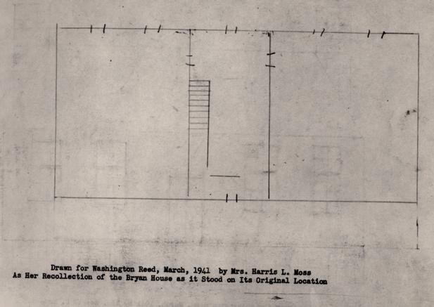 Plan drawn for Washington Reed
 Blue print map
 Large Blueprint
Large Blueprint