Prentis Store Archaeological Report, Block 18-1 Building 5 Lot 46Originally entitled: "The Prentis Store Site Block 18, Area C Colonial Lot 46 Report on 1969 Archaeological Excavations"
Colonial Williamsburg Foundation Library Research Report Series - 1403
Colonial Williamsburg Foundation Library
Williamsburg, Virginia
1990
THE PRENTIS STORE SITE
Block 18, Area C
Colonial Lot 46REPORT ON 1969 ARCHAEOLOGICAL EXCAVATIONS
TABLE OF CONTENTS
| Page | |
| Table of Figures | |
| Table of Photographs | |
| Acknowledgments | |
| Introduction | |
| Precis of the Prentis Site History | 1 |
| The Site's Eighteenth-Century Occupation | 1 |
| The Site's Post-Eighteenth-Century Occupation | 5 |
| Documentation Pertaining to the Site's Buildings | 9 |
| The Archaeology of Lot 46 | 13 |
| The Eighteenth-Century Buildings | 13 |
| Structure A | 13 |
| Structure B | 14 |
| Structure C | 15 |
| Structure D | 18 |
| Structure E | 19 |
| The Post-Eighteenth-Century Buildings | 22 |
| Structure P | 22 |
| Structure G | 24 |
| Structure H | 25 |
| Structure J | 26 |
| Structure K | 27 |
| Structure L | 27 |
| Structure M | 27 |
| Twentieth-Century Buildings on the Site in 1930 | 28 |
| The Architectural Evidence | 28 |
| The Landscape Evidence | 31 |
| Fencelines | 31 |
| Drains | 31 |
| Walkways | 32 |
| Colonial Grades | 33 |
| Eighteenth-Century Rubbish Pits | 34 |
| Pits and Trenches of Uncertain Purpose | 36 |
| The Wells | 38 |
| Well A | 39 |
| Well B | 40 |
| The Artifacts (Summary) | 41 |
| Conclusions | 42 |
| Footnotes | 44 |
| Appendix I Table of Excavation Register Numbers mentioned in the text and illustrations | 47 |
| Appendix II Dating of the Excavation Register groups from the Prentis Site | 56 |
| Appendix III Descriptions and Dating of the Modern Bottles Recovered from the Prentis Site | 77 |
| Figure 1 Detail of Lot 46 from the Frenchman's Map | Following Page 1 |
| Figure 2Plan of Structures A and B | Following Page 13 |
| Figure 3 Proposed south elevations of Structures A and B | Following Page 14 |
| Figure 4 Comparison of Structure C's remains in 1946 and 1969 | Following Page 15 |
| Figure 5 Plan of Structures D and E | Following Page 18 |
| Figure 6 East/west section showing relationship of surviving strata to Structure E's east wall. | Following Page 21 |
| Figure 7 Structural remains in the southern portion of Lot 46 | Following Page 23 |
| Figure 8Features uncovered in western portion of the site | Following Page 25 |
| Figure 9Nineteenth- and twentieth-century buildings in the south-east quarter of the property | Following Page 26 |
| Figure 10Post-eighteenth-century buildings in the northern portion of the site | Following Page 27 |
| Figure 11 North/south section showing relative positions where the early window glass was found | Following Page 29 |
| Figure 12 East/west section across southern edge of area excavated in 1969 | Following Page 32 |
| Figure 13North/south section showing various grade levels throughout the site's history | Following Page 33 |
| Figure 14East/west section showing changes in the property's contours | Following Page 33 |
| Figure 15East/west section across the trench of uncertain purpose | Following Page 37 |
| Figure 16 Prentis Site key plan | On back pocket |
NOTE: The Master's Plan for this site's archaeological discoveries is on file in the Department of Archaeology and a copy can be found on file in the Department of Architectural Research.
| Frontispiece | Detail of circa 1888 photograph showing Prentis Store and neighboring buildings |
| Plate I | Extant Prentis Store prior to restoration |
| Plate II | Initials and date found on Prentis Store plaster |
| Plate III | Excavated remains of "Blair Storehouse" |
| Plate IV | Comparison of Structure C in 1946 and 1969 |
| Plate V | Robbed wall trenches of Structure D |
| Plate VI | Surviving foundations in Structure E |
| Plate VII | Excavated evidence of Structure F |
| Plate VIII | Chimney foundation in Structure H |
| Plate IX | Fractured crown pane found north of Structure D |
| Plate X | Two levels of paving in south portion of site |
| Plate XI | Large rectangular pit of uncertain purpose |
| Plate XII | Section of the long north/south trench of uncertain purpose |
| Plate XIII | Excavated shaft of Well B |
| Plate XIV | Close-up of Well B's lining. |
Plates I through XIV are located in the rear of the volume.
ACKNOWLEDGMENTS
The successful completion of an excavation; whether it be large.or small, involves a great number of people. Most of them, of course, are just performing their normal duties as employees of Colonial Williamsburg; however, this does not diminish the gratitude felt by those charged with archaeologically investigating a colonial site obviously, every member of the Department of Archaeology was involved in one way or the other with the Prentis project and that team effort was invaluable not only in the recovery of artifacts, but also the processing, treating, research and final storage of them.
Special thanks go also to members of the Landscape and Architecture Departments for their assistance and advice. The Research Department staff provided the historical documentation for this report as well as supplied answers to queries which materialized during the excavation. We are also most grateful to Mr. Douglas White who handled all of the surveying work for the project.
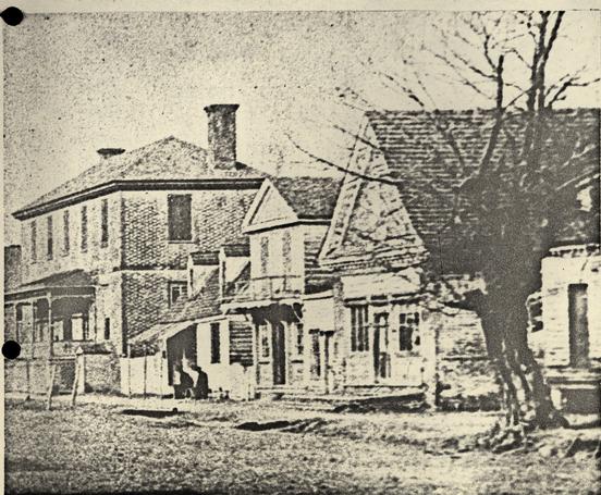 Figure 1 - Detail of circa 1888 photograph, taken by Mr. C.W. Coleman, showing the Prentis Store (right) and, on the same property, two smaller frame structures. The large brick building (left) is the extant Ludwell-Paradise House. Photographed from the southeast. 517-1668
INTRODUCTION
The present archaeological survey of the Prentis Store property (Block 18, Area C) began on May 5th and continued through the 9th of December, 1969. The site had been subjected to two previous excavations; the first during the summer months of 1930 and then again in 1946. Consequently, the main objective of the most recent investigation was to add to our knowledge any evidence that may have escaped those who dug on the lot before. In this respect, the 1969 work was not very successful; only a minimal amount of information was forthcoming, due not only to the disturbances caused by the prior archaeological endeavors but also by the recent grading of the property and the incursion of various utility lines.
Nevertheless, the robbed wall trenches of another outbuilding were uncovered; evidence which had gone unnoticed by workmen.who had previously cross-trenched through the remains. In addition, very important window glass evidence was encountered which could play a significant role in the reconstruction planning of the earlier buildings on the property. Although these are but a few of the successes realized during the 1969 excavations, the site was not considered rich either in colonial features or artifacts.
The following report covers the material which will be pertinent to those planning to return the property to its approximate appearance when the Prentis family occupied the lot.
PRECIS OF THE PRENTIS SITE HISTORY
The half-acre plot, known now as the Prentis Store property and designated Lot #46 by the city planners, is located on the north side of Duke of Gloucester Street between the Ludwell-Paradise House and Colonial Street. The northerly limit is Nicholson Street (Fig. 1). In this type of report, a thorough coverage of the site's historical documentation would be gratuitous so the following data represents only that which will prepare the reader for a better understanding of the archaeological evidence.
The Site's Eighteenth-Century Occupation
The initial owner of Lot 46 was Dr. Archibald Blair, who acquired the land from the Trustees of Williamsburg on November 18, 1700. 1 The deed contained the usual stipulation that Blair must construct a 20' x 30' dwelling within twenty-four months or relinquish all rights to the property. 2 Apparently, he did not meet the requirements because the city had regained possession sometime prior to 1715. In that year, the Trustees granted Lot 46, along with two others, to William Timson of York County. 3 The fact that Timson was directed to build a suitable dwelling on each of the parcels undoubtedly means that no substantial structures were in existence on either of the lots in 1715.
Timson held the property for slightly more than twenty-
six months (March 17, 1715 to May 31, 1717) but, even though
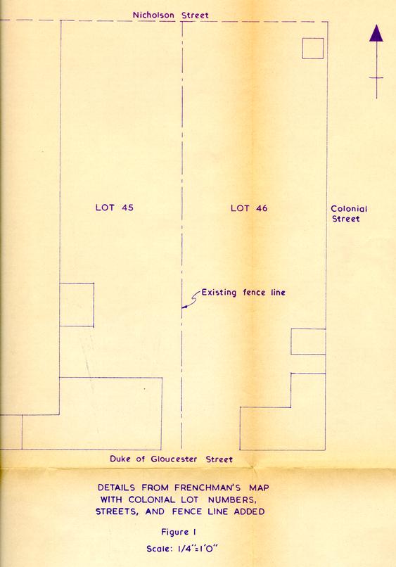 Figure 1
his ownership was short-lived, he was probably responsible for the construction of the earliest building yet discovered archaeologically on Lot 46. 4 Timson sold the land and "ye houses thereon" to a tailor named James Shield 5 whose tenure seems to have been equally short-lived. By 1719, Archibald Blair was again on the premises.
Figure 1
his ownership was short-lived, he was probably responsible for the construction of the earliest building yet discovered archaeologically on Lot 46. 4 Timson sold the land and "ye houses thereon" to a tailor named James Shield 5 whose tenure seems to have been equally short-lived. By 1719, Archibald Blair was again on the premises.
Sometime before 1705, Blair became involved in a partnership business with his brother, the Reverend James Blair and another prominent colonist, Col. Philip Ludwell of "Greenspring." The venture was apparently quite successful. In 1705, Governor Nicholson described it as being "one of the principal stores in the Colony" 6 and later, in 1718, Lieutenant-Governor Spottswood mentioned that it was "one of the most considerable Trading Stores in this Country." 7 Unfortunately, no surviving record indicates the.location of the enterprise during its early years but, by 1719, Blair was operating a store on Lot 46. This last piece of evidence was found in a deed for Lot 47 (located east of the Blair lot) which was listed as being "between the Storehouse of Mr Archibald Blair and the house of Henry Gill...". 8
Ludwell presumably disposed of his portion of the business before his death in 1727 because in 1733 the store was jointly owned by the Blair brothers. 9 Archibald died in 1733 and thereafter the firm's control went to stockholders rather than to partners. James Blair retained his half-interest while the other was divided equally between Archibald's three
3
married daughters: Sarah Cary, Ann Whiting, and Elizabeth
Bolling. 10 Elizabeth and her husband, John elected to sell their one-sixth share to William Prentis; a man who had been associated with Dr. Blair and the store since 1721. Prentis was chosen to manage the newly reorganized venture and the store's trademark was altered from __ to __  the latter probably representing the initials of the four stockholders (Blair, Whiting, Cary, and Prentis), although the WP could stand for William Prentis.
The company continued to grow and prosper under Prentis' direction. For example, during the thirty-two years that he was at the helm, the trade receivables rose from £ 3,210 in 1733 to £ 11,241 in 1765. 11 The total net income for the same period was £ 34,493 and the owner's equity increased from £ 7.000 to £ 17,391. 12 Unfortunately, from the historian's point of view, business was so good that the management was not obliged to advertise in the local newspapers. Nevertheless, surviving documents, other than public notices and store inventories, do give some insight as to the types of wares 13 available. All that need be said here, however, is that the firm offered a wide variety of goods; from clothing and haberdashery to bridles and saddle blankets, from books and writing material to hinges, paint and nails.
The company's stock ownership became more complicated as time passed because of transfers by sale or bequest but, since these transactions have no significant bearing on the 4 archaeological evidence, they have been omitted here. Nevertheless, it should be noted that, from 1733, when William took charge, until the business was dissolved in 1779, the firm's manager was always a member of the Prentis family. The name of the company was altered to reflect each change in the leadership; beginning as ARCHIBALD BLAIR & COMPANY, then WILLIAM PRENTIS & COMPANY, next JOHN PRENTIS & COMPANY, and finally ROBERT PRENTIS & COMPANY. The liquidation of the firm brought to a close one of the most successful mercantile enterprises in colonial Virginia. The final dissolution came on the 10th of November, 1779 but, by that time, Robert Prentis, the store's last manager, had purchased the land and buildings at public auction for £ 1,000.
Robert attempted to carry on a business for himself and, at the same time, collect some of the debts owed the defunct corporation but, in 1783, he decided to leave America. Three years later, Robert had settled in Trinidad where he died circa 1608... However, prior to his death, he had willed the "Store Houses & Lot in ... Williamsburg" 14 to his nephew, William; a Richmond printer from circa 1781 to 1785 and a newspaper publisher in Petersburg from 1786 to 1804. There is some question as to whether William gained possession of Lot 46 by bequest or by purchasing the property from his uncle. on February 20, 1800, Robert wrote to Joseph Prentis, his "true and Lawful Attorney" 15
"...As the Power of Attorney I formerly made to you, I should suppose 5 would be fully sufficient for you to pass a Sale of the Store &Lot to W. P. for whom I always intended it..." "... I should wish it to be done, if it can with propriety ..." 16
Therefore, it would seem entirely possible that William purchased the property sometime after the letter was received in Virginia but no deed survives to substantiate such a theory.
The Site's Post-Eighteenth-Century occupation
Lot 46 was presumably leased after Robert's departure, but no extant records indicate to whom or for what purpose. By 1804, Robert Warburton was renting and attempting to buy Lot 46 but it was not until 1809 that the transfer of ownership was finalized. 17 Warburton died sometime before April 8, 1811 because, on that date, the commissioners of his estate 18 sold the land to Samuel Shield, Jr. Apparently, Shield had difficulties in obtaining a clear title to the property. He sold the lot to William C. Drummond in 1814 but in 1815 and again in 1821 he had to make payments to Warburton's heirs so the sale to Drummond would be valid. The extant Williamsburg Land Tax records never listed Shield as the owner; instead, they indicate that, from 1811 through 1817, William C. Drummond (sometimes called Cary Drummond) was the possessor of this parcel.
At any rate, Drummond sold the "lot and brick store" to William Lee in 1818. 19 Within three years, Lee had died and the trustees of his estate sold the property to Randolph Roper.. 6 By 1825, William H. Lee had obtained the land from "James W. Roper, who purchased of Henry Edloe, Commissioner in Chancery for Rand. Roper's Est.". 20 Lee maintained control of the entire lot for thirteen years before selling the western most part to Sheldon &Maupin, merchants of Williamsburg. 21 In 1847, this portion of the property was transferred to "Somerset Moore, trustee &c." with the tax records noting that it was "Form. S. &Maupin in 1846." 22 According to those extant documents, no further change occurred in the ownership of the western part of the lot through 1861.
Meanwhile, Lee retained the eastern portion of the site until 1841; at which time, a firm known as Millington &Griffin purchased it. 23 Three years later, John Millington 24 apparently bought out his partner because he is listed as the owner of the eastern part of Lot 46 from 1844 until the tax records end in 1861. 25 The fact that both Millington and Griffin were physicians, could lead one to conjecture that they used the existing brick store as an apothecary shop; but a theory is not needed since extant documentation verifies the fact (see J. Charles' statement on following page). It probably was similarly utilized by Millington after the partnership was dissolved, but, although he owned this segment of Lot 46 until 1861 (as noted above), his actual occupancy ended in 1848 when he moved to Mississippi. Consequently, if the land tax records are correct, the existing store could have been leased after Millington's departure and, if so, Dr. Edward 7 Camm may have been the building's tenant.
Unfortunately, certain gaps in the documentation leave some question as to when Dr. Camm acquired a portion of Lot 46. Mr. John S. Charles, an elderly citizen of Williamsburg, recalled that:
" ... The house on the east of the Paradice House was a small one story house with dormer windows ... The house next on the east ... was Dr. Camm's 'drug store', built not many years before the War. The brick house, now standing on the corner ...was used as an apothecary shop, but was used for other purposes when the new 'drug store' was built." 26
From this account, it would seem that Camm had purchased a slice out of the center of the site before 1861, unless he already owned the eastern part of the lot. The wording also seems to insinuate that Camm had been occupying the brick store before constructing the new building. Although no records survive to indicate when he obtained the property, Camm I must have purchased the eastern two-thirds of Lot 46 prior to his death in 1871. This last was deduced from the fact that his widow, Mrs. Eliza Camm, "devisee of Edward Camm," sold the eastern portion of the lot to William W. Vest in 1877 with the deed describing the parcel as:
"..that Lot of land in the city of Williamsburg, with the buildings thereon, bounded on the south by Main Street, east by Colonial Street, north by Nicholson Street and west by the lot of Julia minson, which the said Camm purchased of John Millington ..." 27
As noted on page 6, the land tax records indicate that 8 "Somerset Moore, trustee &c." was in control of the western portion of the property through 1861. In her recollections of 1861 Williamsburg, Mrs. Victoris King Lee, remembered the structure and the occupant:
"...Like so many other frame buildings in Williamsburg, this was a story and a half house. A negro woman, Julia Minson owned and lived in this cottage." 28
Thus, it would seem that around 1861, Julia Minson acquired that portion of the site and, as mentioned on page 7, she still held the parcel in 1877, when Mrs. Camm sold the adjoining land to W.W. Vest. No records survive to indicate when Julia Minson's tenure ended but, from what follows, it must have been between 1884 and 1891.
The brick store property passed from W.W. Vest to G. Teiser in 1884 and the deed indicated that the land was:
"...bounded on the south by Main Street; east by Colonial Street; north by Nicholson Street; and, west by the lot of Julia Minson ... " 29
By 1891, Samuel Harris had purchased that area described as:
" ... That certain piece or parcel of land ... bounded as follows: North by Nicholson Street; west by the lot of B.D. Peachy, and by the lot known as Camm's Old Drug Store lot; east by a cross street; and, south by Duke of Gloucester Street..." 30
Harris retained the property for four years before selling it to Thomas Hughes; 31 who in turn conveyed the land to Christine N. Henderson in 1912. 32 In 1927, Dr. W.A.R. Goodwin, on behalf of the Williamsburg Restoration, purchased the 9 property from the surviving unmarried Henderson children.
Documentation Pertaining to the Site's Buildings
The historical dating evidence for the two main eighteenth-century storehouses on the site will only be discussed briefly because the 1969 archaeological work did not include a re-study of those buildings.
As mentioned on page 2, William Timson has been given credit for the construction of the first major building (denoted Structure A in this report) to be erected on Lot 46. This assumption was based on the fact that when he obtained the land from the city he was required to build a dwelling with minimum prescribed dimensions in order to maintain control of the property. Since he did retain ownership past the deadline (twenty-four months), Timson presumably had fulfilled his obligation to the city. If this theory isvalid, the structure, known now as the Archibald Blair Storehouse, was erected between 1715 and 1717. A thorough examination of extant letters and records by the Research Department has revealed that, by the end of the century, this building was either no longer standing or was considered unworthy of any mention. Therefore, it has,been conjectured that the life of Structure A began circa 1716 and ended around 1800.
The existing brick store (Structure B) was completed circa 1740 but the construction work probably began in 1739. These dates have been derived from, at least, three sources. 10 The extant annual reports of stock for the WILLIAM PRENTIS & COMPANY indicate that in 1739 the value of "the Store houses & Lots" was E 150 current money of Virginia. 33 In November of the following year, the "Store Houses & Lots" were listed as being worth £ 350; an increase of £ 200. 34 Sometime prior to the next stock settlement, the company had sold a lot and building so the November, 1741, notation indicated that the "Store Houses & Lot" were valued at L 290; 35 making that which was sold worth only £ 60. Therefore, before November, 1740, a new structure was erected on Lot 46 and, without further evidence, one could conjecture that this building was the existing brick storehouse. However, additional substantiating facts were forthcoming.
In 1959, during an architectural examination of the premises, Mr. E.L. Phillips found the year 1740 and the initials E J P scratched in the original plaster on the interior face of the building's south gable (plate II). This evidence would seem to verify that this was the structure added to Lot 46 in 1740. Still another extant document helps substantiate the fact. In 1743, William Prentis was compelled to lease, from the city, a strip of land measuring 4' x 36' 36. because his company's new store had encroached onto the lane which divided Lots 46 and 47. Since the rent was made retroactive to 1738/39, it must be assumed that the construction work began in the early part of 1739. 37
During the years 1778, 1779, and 1783, Robert Prentis 11 contracted with Humphrey Harwood, a local carpenter, to effect certain repairs on buildings presumed to be located on Lot 46. Unfortunately, Harwood's ledgers do not specifically indicate that the work was performed on the site in question but, the three notations to be mentioned here seemingly do relate to the store property. on March 13, 1779, the accounts indicate that Prentis was charged for "putting up Step to Store" and for "larthing and plastering Nesacary House." 38 Two days earlier, Harwood had billed Prentis for "underpining Stable" and "3 days labour." 39 The proximity of dates would seem to suggest that the work was undertaken in the same area and, since one entry mentioned the store, it has been conjectured that these three projects were accomplished on Lot 46. If valid, the site not only contained two store houses in 1779 but also a stable and a privy.
It should be noted that Robert Prentis offered four storehouses to the Board of Trade in June, 1778 40 and his overture was promptly accepted. Although there is no proof that all four buildings were situated on Lot 46, the possibility remains because the extant Frenchman's Map (Fig. 1) of 1781 shows two smaller structures besides the two.storehouses known to have been on.the property at that time. One of these outbuildings could have been the stable, mentioned above, as it is located near the northeast corner of the lot, away from the business activity. The other small structure is depicted as being north of the existing "Prentis Store."
12Some of the nineteenth and twentieth-century structural changes on the property have already been discussed, and therefore only a brief review of these is needed here. By 1861, there were three buildings on the lot fronting on Duke of Gloucester Street: Julia Minson owned and lived in the westerly one, while Dr. Camm had built a frame "drug store" between Minson's house and the existing brick structure. A photograph of Lot 46, taken in 1888 or 1889 by Mr. C. W. Coleman (see Frontispiece), shows two small frame buildings west of the brick store and it would seem possible that these had survived from circa 1861. Evidence of at least five other nineteenth and twentieth-century buildings was found during the present excavation but their remains will be discussed in the archaeological section of this report.
THE ARCHAEOLOGY OF LOT 46
Little strictly historical evidence for the evolution or even the existence of the site's outbuildings survives. Consequently, one of the major objectives of all three archaeological excavations was to find out what types of dependencies existed on the lot during the Prentis family's occupancy. Unfortunately, the first persons to uncover structural remains have a much better chance of determining the date and utilization of a building than do those re-studying the foundations for the second or third time. This is because archaeology in itself is destructive. Nevertheless, the 1969 work was moderately successful in providing some additional knowledge to aid the reconstruction planning.
As mentioned previously, the present-investigation did not include the existing brick storehouse or the Timson-owned structure; both of which front onto Duke of Gloucester Street. Even so, a brief orientation concerning them may be helpful in keepinq-the 1969 discoveries in perspective.
The Eighteenth-Century Buildings
Structure A.
As noted on pages 2 and 9, William Timson was probably responsible for erecting the dwelling, known now as the "Archibald Blair Storehouse" (Fig. 2). The foundations were first uncovered in 1930 and then again in 1946 but no archaeological report was written on either project. However, extant maps and photographs (plate III) indicate that the
 Figure 2 - Features and Limit of Excavation Around Previoulsy Discovered Structure A and Extant Prentis Store - oversized image
14
building measured 32'6" x 29'10" and its exterior walls, for the most part, were one and a half bricks thick. The cellar floor had been paved with bricks,laid in oyster shell mortar and, in the northeast portion of the basement, evidence of, what could have been a vaulted room was found. The extant 1946 plan 41 shows the location of an interior stairway near the northwest corner of the structure and a circular brick sump in the southeast corner. An easterly bulkhead entrance had been sealed up, presumably at the time the existing c.1740 brick structure was erected, and a new set of exterior cellar steps was installed on the south side of the building.
Figure 2 - Features and Limit of Excavation Around Previoulsy Discovered Structure A and Extant Prentis Store - oversized image
14
building measured 32'6" x 29'10" and its exterior walls, for the most part, were one and a half bricks thick. The cellar floor had been paved with bricks,laid in oyster shell mortar and, in the northeast portion of the basement, evidence of, what could have been a vaulted room was found. The extant 1946 plan 41 shows the location of an interior stairway near the northwest corner of the structure and a circular brick sump in the southeast corner. An easterly bulkhead entrance had been sealed up, presumably at the time the existing c.1740 brick structure was erected, and a new set of exterior cellar steps was installed on the south side of the building.
According to the research report on this property, the present intentions of Colonial Williamsburg include the reconstruction of the frame storehouse "on its original foundations, to as near its eighteenth-century appearance as possible, on the basis of evidence found in excavating the site, supplemented by surviving early eighteenth century precedent for a building of its approximate shape and size." 42 In conjunction with this plan, the Architectural Department has submitted several drawings including one showing a proposed south elevation prepared by Mr. E.L. Phillips (Fig. 3). It should be noted here tha t the 1969 archaeological activity provided important precedence for the types of windows that may have been used in this structure. This evidence is discussed fully in the architectural finds section on page 29.
Structure B.
Very little need be said about this building
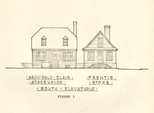 Figure 3
15
because, since it is one of the town's original eighteenth-century structures (plate I), its restoration relies on architectural rather than on archaeological evidence. Nevertheless, a few test holes were sunk against the north and west walls in 1969, but this exercise only proved that the areas had been disturbed previously both by the insertion of modern utility lines and by prior excavation activity. Slightly better success was had in 1959, when Messrs. Knight and Phillips found evidence of, what could have been, a bulkhead entrance near the cellar's northwest corner (Fig. 2). In addition, they discovered a small section of bri.ckwork near the building's exterior northeast corner and this was presumed to be part of the structure's northerly chimney.
Figure 3
15
because, since it is one of the town's original eighteenth-century structures (plate I), its restoration relies on architectural rather than on archaeological evidence. Nevertheless, a few test holes were sunk against the north and west walls in 1969, but this exercise only proved that the areas had been disturbed previously both by the insertion of modern utility lines and by prior excavation activity. Slightly better success was had in 1959, when Messrs. Knight and Phillips found evidence of, what could have been, a bulkhead entrance near the cellar's northwest corner (Fig. 2). In addition, they discovered a small section of bri.ckwork near the building's exterior northeast corner and this was presumed to be part of the structure's northerly chimney.
As indicated on page 10, the extant brick storehouse was, erected around 1740 and, although a comparative analysis of the clays has yet to be made, there is a possibility that the contractor made the bricks from clay obtained on Lot 46. This contingency and its potential importance to future programs is explained on page 38.
Structure C.
During the 1946 Prentis Site excavations, Mr. J.M. Knight, and his crews uncovered evidence of an outbuilding approximately 35' north of the existing store. The extant plans of that year's work indicate that the structure had an east/west measurement of 15'7" and a north/south dimension of 21'6" (+ or -). The foundation remains restudied in
Figure 4 - Comparison Structure C's Remains in 1946 &1969 - oversized image
16
1969 closely resemble those drawn by Mr. Knight except that the 1946 map shows both a southeast and a southwest corner (Fig. 4); features which had completely vanished by 1969. This would not seem so peculiar except for the fact that the 1946 photographs fail to show corners on the surviving brickwork (plate IV). Consequently, the plan to reconstruct a building on these footings must be re-evaluated.
The foundation that survived and was re-examined in 1969 consisted of three'short.sections of an east/west wall. The shell-mortared bricks had average dimensions of 8-¼" x 3-¾" x 2-¼" and.had been laid to form a 9" footing. A post hole (E.R. 1453F) was found to have cut through the brickwork at the western end, leaving what appeared to be a closer. It could not be determined if this feature had been dug against a closer or if the appearance of one had been created by cutting through a whole brick. Nevertheless, the 1946 photoqraphs show that same chopped brick along with a small wooden stake a few inches westward. Thus, one would assume that Mr. Knight believed the brick to be a closer and was thus prompted to estimate the position of the building's southwest corner.
Dating evidence for the structure's erection and abandonment was almost unobtainable because the soil in the area had been disturbed down to the brickwork, while the foundations were sitting on the natural subsoil. However, a large rectangular pit (E.R. 1454M) was discovered directly beneath the 17 position of the alleged southeast corner, and this feature's artifacts, as well as its location, help to date the structure. The hole began so close to the point where we lost the brick wall, it could be assumed that the feature had cut through the foundation and thereby post-dated the building's abandoment. The artifacts retrieved from the pit included no fewer than 50 wine bottle bottoms, a fragment of a baluster stem from a wine glass, pieces of German stoneware, Chinese porcelain, and creamware. However, the latest item among the assemblage was a fragment of Rouen faience which does not appear to have reached British America prior to the Revolution. The earliest documentary reference, as yet located, occurs in 1778. 43 Thus, the pit must have been filled in after c.1778 and, if it cut through the abandoned building, then it could be argued that the structure was in use during the colonial period. However, this could not have been the case if one accepts the evidence that Mr. Knight insists was uncovered in his digging some twenty-three years ago.
As mentioned on the previous page, this post c.1778 hole was situated beneath the position of the building's southeast corner. Thus, if Mr. Knight found and recorded the return properly, the structure's southeast footings overlay the post c.1778 feature, meaning that the dependency could not have existed in the colonial period. It seems entirely possible that, if the above argument is valid, the building was erected soon after the pit was filled, because the extant Frenchman's map of 1781 (?) (Fig. 1) indicates that a small structure was standing in this general vicinity. However, it should be noted that the sparse evidence that remained to be studied in 1969 was not enough to determine if the east/west wall returned southward or northward. The unfortunate truth of the matter is we do not now have enough physical evidence to substantiate the positioning of the building--no matter what date it happens to be. Thus, if further reconstruction planning on this~portion of the Prentis project is undertaken, it will have to be attempted without the benefit of proper authentication.
Structure D.
The entire site was found to have been extensively disturbed by various utility and archaeological ditches. Indeed, the robbed wall lines of this dependency (Fig. 5) had been cut through by no fewer than three crosstrenches, a north/south water line, and a rather shallow channel presumed to be from the 1930 excavations. Nevertheless, the surviving evidence seemed to indicate the structure had approximate dimensions of 9'0" x 17'6", (plate V). No hints as to the. building's utilization were found in the undisturbed strata, but the recovered artifacts did provide fairly reliable evidence of its life span.
The datable material within the brick and mortar-filled robber trenches (E.R. 1485D & 14861) suggested that the building was torn down sometime after c.1782. This assumption was based on the fact that no fewer than three fragments of pearl
Figure 5 - Remains of Two Outbuildings Located Near the Property's Eastern Limit - oversized image
19
were found amid the destruction rubble. In addition, pieces of creamware, German stoneware, and white saltglaze were recovered, along with many fragments of wine bottle glass. It would seem possible that the reason that this structure was not shown on the Frenchman's Map was because the building was either being demolished or was in such a ruinous state that its destruction was inevitable. However, it is just as possible that the draftsman merely inadvertently failed to show it.
No definite construction date was determinable; however, a stratum of ashes (E.R. 1486K) passed beneath the robbed wall trenches and the artifacts recovered from this layer suggested a deposition of post c.1715 - 1720. Thus, the dependency had to have been erected sometime after the ashes were generated, but it was impossible to discove.- just how much later. It should be noted here that the ash layer was apparently formed early in the site's life during some type of construction activity. This aspect and its significance is discussed on page 29.
Structure E.
The most perplexing remains of an outbuilding, located some 32'6" north of Structure D, were again studied during the 1969 project (Fig. 5). The foundations were first uncovered in 1930 and again in 1946 but, even after all three examinations, no irrefutable evidence was revealed to aid in determining the dependency's purpose. Mr. Knight, on his 1946 plan, labeled it a "dairy or small ice house" and in 1969, Mr. Paul Buchanan thought the building may have been 20 a privy. it could have served equally well as a root cellar or as a storage area for some specialized commodity offered in the Prentis store. As it now stands, the structure's purpose remains a mystery. Nevertheless, the stratigraphy surrounding the brickwork was not as badly disturbed as in other areas of the site, consequently a certain amount of additional knowledge about the structure's dating was determinable in 1969. However, before discussing this evidence, a description of the surviving foundations is in order.
The feature possessed a 4'0" x 5'7" pit that extended into the ground some 3'2". The 9" walls had been constructed of hand-made bricks with average dimensions of 8-½" x 4" x 2-5/8" and were held in place by oyster-shell mortar. The floor had been paved but no mortar was found between or beneat.h the tightly laid bricks. Apparently, the hole had been dug larger than the area to be linecl since, even though the bricks in the walls were laid from within the pit (determined on the basis of protruding mortar on the exterior), backfilled dirt was found around the outside of these footings.
The top existing course on the west wall extended a distance of 24" north and south of the central pit (plate VI). The easterly wall was probably similarly constructed but only a 1'1" extension remained on the south end,while that at the north was destro yed when a live oak was planted neat the northeast corner of the building. The upper course of bricks, including these projections, was void of mortar traces on the 21 top surface which would seem to suggest that this was as high as the brickwork was originally laid. If true, the singlecourse extensions were probably used to support a frame building-and, at the same time, keep the sill off the ground so as to minimize decay. However, it could be argued that the mortar was removed during previous archaeological endeavors or through exposure to the elements after the excavations were concluded.
As noted in the preceding paragraph, after the structure's central pit was lined, the surplus space outside the walls was back-filled. The artifacts recovered from this dirt (E.R. 1471Q, 1472Q, & 1473A) suggested a deposition of post c.1720. Such evidence might seem to indicate that the outbuilding was erected soon after Timson constructed his storehouse (Structure A). However, other factors tend to refute this theory in favor of a building date at least 15 to 20 years later.
A layer of dark brown clay filled with brick rubble (E.R. 1471P, 1475P & 1472L) passed,beneath the foundation's northerly and southerly extensions (Fig. 6). The artifacts recovered from the stratum included datable material which suggested a post c.1740 deposition. Thus, since the mortar in the upper course with its projections seemed to be the same as that used for securing the remaining brickwork, it must be assumed that the building was not erected until sometime after c.1740. A possible explanation for the misleading c.1720 date
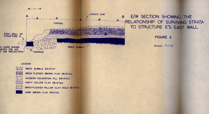 Figure 6 - E/W Section Showing the Relationship of Surviving Strata to Structure E's East Wall
22
could be that the workmen, while digging the structure's central pit, shoveled through earlier strata and subsequently redeposited that same dirt around the foundation when the brick layers completed their activity.
Figure 6 - E/W Section Showing the Relationship of Surviving Strata to Structure E's East Wall
22
could be that the workmen, while digging the structure's central pit, shoveled through earlier strata and subsequently redeposited that same dirt around the foundation when the brick layers completed their activity.
There is still another pecularity about the backfilling surrounding the exterior walls. A quantity of dirt had been thrown into the space between the back and the western face of the walls and this was topped with what was probably wet mortar. Above this mortar layer was found more dirt and then another stratum of mortar. This last deposit contained embedded brick fragments which appeared to have been pruposely chopped to fit a 2"-2-½" wide cavity and then laid to form a flat surface at right angles to the structure's west wall. It is not uncommon to find waste construction materials in builder's trenches but this type of debris is usually tossed into the ditches instead of being carefully laid. The way this brick and mortar had been deposited made it appear almost like a wall that had been cut through by the construction of a later building.
The Post-Eighteenth-Century Buildings
Structure F.
An extant 1930 map of Lot 46 indicates the position of a rather long and thin building some 8' west of the existing Prentis storehouse. 44 The structure was labeled "Barber Shop" but it seems probable that it was the same building erected by Dr. Camm in c.1861 and used initially as a drug store. During the 1969 excavations, evidence of this 23 structure's first and second periods was uncovered north of the area where earlier digging had revealed the remains of the "Archibald Blair Storehouse" (Structure A).
A short section of, what was presumed to be, the building's original north wall was found, as was a portion of its northwest corner (Fig. 7). However, the majority of the structure's footings had been erected over the back-filled cellar in Structure A. Consequently, any surviving brickwork was probably destroyed prior to or during the previous archaeological studies of that basement. Nevertheless, the extant plans of this nineteenth-century structure indicate that it initially had exterior dimensions of approximately 37'3" x 15'6". The maps also show an addition extending northward from the original building. Parts of three different brick piers which helped support this annex were discovered in 1969 and their positions are indicated on Figures 2 and 7.
It was not possible to determine a construction date archaeologically for the "barber shop" or its addition. This was due primarily because the surviving foundations were resting on the natural subsoil so no datable material was beneath them and because the area surrounding the brickwork was greatly disturbed by various modern features. However, a portion of a brick rubble path was discovered north and west of the original structure's northwest corner in a location that was covered by the northerly extension (plate VII). This path
Figure 7 - Structural Remains in the Southern Portion of Lot 46 Including the Extant Prentis Store - oversized image
24
undoubtedly was installed to service the main building so, if it can be assumed that the walkway was laid soon after the structure was erected, the date for one can serve as a conjectural date for the other.
The light brown clay layer (E.R. 1414K) which predated the paving contained material suggesting a post c.1830 deposition while the gray sand (E.R. 1414E) found between and beneath the bricks included post c.1880 artifacts. Thus, it would seem probable that the original structure was built sometime after c.1830 and, since the path was covered by the northerly annex, the latter must have been added after c.1880. However, it must be warned that this dating evidence is highly conjectural since it is based on assumptions that may or may not be valid and also because of the fact that only a minimal portion of the building's foundations were investigated.
Structure G.
As noted on pages 8 and 12, by 1861 Julia Minson occupied a dwelling near the southwest corner of the property. Although during the present study that area was almost entirely excavated (balks were retained), no traces of this building were found. However, the photographs and drawings of the. basement in Structure A, prepared in 1946,. show the remains of a later chimney, east wall, and northeast pier which undoubtedly belong to this building (Fig. 7). Therefore, it would seem possible that if these have not been destroyed, some dating evidence could be found when 25 the cellar is again dug out prior to reconstruction activity.
Structure H.
The footings for this nineteenth-century pier-supported outbuilding were first discovered in 1930 45 and were again studied in 1946 and 1969. The surviving brickwork was located in the western portion of the site some 78' north of Duke of Gloucester Street (Fig. 8). The structure had exterior measurements of 12'3" x 12'3" and possessed a westerly chimney whose bricks had traces of oyster-shell mortar but were held together by yellowish sandy nineteenth-century mortar.
The chimney's base had been lowered 1'8" below that of the corner piers because the workmen had to go that deep in order to lay the foundation on firm ground (plate VIII). This was due to the fact that the fireplace had been erected near the center of a long north/south trench filled in during the eighteenth century. (This feature is discussed on page 38. The chimeny's floor had been laid two courses thick and evidence of burning was found on the bricks in the upper level; however, the discoloration was also discovered on bricks projecting outside the fireplacels southern wall. Therefore, at least some of these bricks must have been salvaged from an eighteenth-century fireplace and reused here as was evidenced by the previously mentioned presence of shell mortar on the faces of many of them.
It was not possible to discover the purpose for this outbuilding but, even though the stratigraphy had been
Figure 8 - Features Uncovered in the Wetern Portion of Lot 46 - oversized image
26
destroyed in the area of the corner piers, dating evidence for the chimney's (and probably the entire building's) construction was determinable. The builder's trench for the south wall of the fireplace (E.R. 1422E) survived and it was filled with mixed brown clay and artifacts which had been deposited sometime after c.1840. Thus, if the building and its chimney were erected contemporaneously, the post c.1840 date serves as the construction terminus post quem for both.
Structure J.
A total of 10 piers, belonging to a building labeled "Negro House" on an existing 1930 plan, 46 were encountered in the eastern portion of the site (Fig. 9). These, no doubt, had been examined during previous excavations because shallow holes, filled with modern artifacts, were discovered around each of the piers. No dating evidence was found for the construction of this dwelling other than the fact that the mortar between the bricks was typical of that used in the nineteenth or early twentieth centuries.
Another feature which could have had some relationship with this house was'discovered some 2'3" south of its* southernmost piers. In that area was found a more or less rectangular deposit of brick and mortar rubble (E.R. 1456P), measuring approximately 2' x 8' and orientated on an east/west line. Some of the mortar was of the eighteenth-century oyster-shell variety but most of it matched that used in the construction of the dwelling. The artifacts recovered from this debris
Figure 9 - 19th and 20th Century Structure in the S/E Quater of Lot 46 - oversized image
27
indicated a deposition of post c.1825. The rubble may have been waste from the construction of the building but, since the area was so disturbed due to modern grading and prior archaeological studies, no clear connection between the debris and the house could be determined.
Structure K.
In 1930, six piers associated with a building, located near the center of the property (Fig. 10), were found and recorded on the extant map of that year's discoveries. 47 Although that area was restudied in 1969, no traces of this brickwork was found. Thus, we must settle with what was noted on the 1930 drawing: "These Foundations 1'- 6" x 1' - 3" 2 Courses". 48
Structure L.
No fewer than six piers, associated with a structure described in 1930 as being "Building Removed Recently Not Old," 49 were again recovered in the northeast quarter of Lot 46 (Fig. 10). Many of the bricks were found to have traces of oyster-shell mortar attached to them but these had been salvaged from elsewhere because that which secured the brickwork was clearly of nineteenth-century vintage. Actually, a few of the piers had been repaired more recently because some of the bricks were of the common machinemade variety. No further evidence was found to help determine a closer construction date nor was it possible to discover the building's purpose.
Structure M.
The 1930 excavations revealed the position of a building in the extreme northeast corner of the site.
Figure 10 - Post 18th Century Building Remains in the Northern Portion of the Site - oversized image
28
Indeed, according to the extant plans of that project, at least 7' of the structure projected beyond the Nicholson Street southern limit (Fig. 10). only one of the piers associated with this house was encountered during the present study but no attempt was made to find those which would have been outside the existing fenced area. The 1930 map labeled these foundations "Building Removed Recently Not Old" 50 and the 1969 archaeological work provided no evidence to refute this statement.
Twentieth-Century Buildings on the Site in 1930
At least three modern structures were standing on the property when the first archaeological project was undertaken. These included a garage, with concrete footings, located immediately north of the Prentis Store, a temporary tool shed positioned over the foundations of Structure H, and a dwelling in the northwest corner of the lot. No evidence of the first two was discovered in 1969 but four piers belonging to the last mentioned one were revealed. Nevertheless, since these structures are of such a late date, no further mention need be made.
The Architectural Evidence
During most archaeological endeavors, clues are discovered to assist the architects in their reconstruction planning. Surviving foundations can indicate the size and shape of structures, as well as the positioning of 29 chimneys, porches, additions, etc. A study of the artifacts may be able to provide precedence for types of hardware used on the buildings, but it is not usually possible to determine which structure each belonged to. The Prentis site was not particularly rich with material of architectural importance; however, the recovery of some hundreds of fragments of early eighteenth-century window glass could have a significant role in future building specifications for Structure A.
As noted on page 19, the robbed footing trenches for Structure D had cut through a rather large ash deposit (E.R. 1486K) and, since the ground beneath them was scorched, they had been generated on the site rather than brought in from elsewhere. This stratum contained bu.rned oyster shells and, what appeared to be, granular lime; the presence of which leads one to conjecture that the layer represented the debris of lime-burning for mortar. The deposit overlay a shallow depression (E.R. 1486L) from which was recovered the above mentioned fragments of unused casement window glass (Fig. 11). No doubt, these broken panes and the limeburning were part of the same construction project occurring, so the artifacts would suggest, between c.1715 and 1725. Thus, it would seem that a case could be made for the debris, both ashes and glass, having been deposited during the construction of the Timson-owned building. This is conjectured not only because of the early artifactual dating but also from the fact that casement-type windows were reportedly
Figure 11 - N/S Section in the Area of Structure D Showing the Position of Window Glass - oversized image
30
being phased out during the first quarter of the eighteenth century and Structure A is the only known building which could have been on the site then.
The glass-filled pit contained portions of no fewer than fifty diamond-shaped panes; all of which were the "size usually found in Williamsburg. Each had a 'square quarrel' shape with an acute angle of about 77°, a length of 6 inches, and an area of 14 2/5 square inches." 51 This "glass had apparently never been used, as no turned lead was found with it, and none of the panes had the marks on the edges that are often seen when lead has been attached to the glass." 52 The fact that the new glass had not been installed would seem to indicate that it was broken either in transit to or on the job but, more importantly, the discovery proves that casement windows were at least intended for if not used in some building on Lot 46.
It should be noted that in this same general area (Fig. 11) was found several pieces of a blue-green crown panel, measuring 8" x 7.5" (plate IX). It was the type which could have been meant for a sash or a shop display window. If the latter were the case, it would seem entirely possible that the size of this pane could provide precedence for the front store window in Structure A. This is due to the fact that this glass evidence was found on the same level as that discussed on the previous page and was also deposited, according to the artifactual dating, near if not during the same construction project.
31The recent archaeological work on the Prentis site provided architectural finds other than the glass evidence but the window panes will no doubt be of much greater importance to those charged with reconstructing the buildings to their eighteenth-century appearance. Also included in the 1969 discoveries were fragments of door locks, along with keys, escutcheons, and lock bolts7 hinges of various sizes and types; turned lead from casement windows; and a few pieces of clay pan tiles along with a similar quantity of roofing slate fragments.
The Landscape Evidence
Fencelines.
During the 1969 excavation season, hundreds of features which appeared to have been postholes were found and redug; however, a combination of archaeological and artifactual dating failed to indicate a single irrefutable fenceline. This could have been due to the extensive disturbance caused by numerous excavations or by the relatively recent grading on parts of the site but, whatever the cause, no definite evidence was discovered'to help in the placement of the inclosures which, undoubtedly, existed during much of the site's history.
Drains.
Only one feature which resembled a drain was encountered on Lot 46 and it was first uncovered by Mr. Knight's workmen in 1946. The extant map of that year's discoveries indicate that this brickwork represented the "Remains of late brick gutter drain." 53 All that survived 32 by 1969 was a slightly curving line of broken bricks which seemed to be oriented along a southwest to northeast course (Fig. 4). The feature apparently cut through the east/west foundations of Structure C which obviously would mean that the drain was constructed after the building was abandoned. Thus, if the structure was not erected until sometime after c.1778 (see page 17), the drain could not possibly have been placed there earlier than the last quarter of the eighteenth century.
A southerly extension of the drain's path would have headed in the direction of Well A (Fig. 16). Therefore, it would seem possible that its purpose was to serve as a receptacle to catch spilled water and carry it away from the well area. If true, the construction date for both the channel and the water supply were probably contemporaneous. This would put the drain's date well into the nineteenth century. Nevertheless, since the feature has little or no bearing on the present plans to return the site to its appearance during the Prenti s family's occupation, nothing more need be said about it.
Walkways.
During the present study, only one section of colonial paving was found on the site, while evidence of at least three nineteenth- or early twentieth-century paths was discovered. One of the latter group apparently serviced Structure P (Fig. 7) but, since this feature has already been discussed in conjunction with that building
Figure 12 - E/W Section Across South Face Areas 1401, 1402, 1403, 1404, and 1405 - oversized image
33
(pp. 23-24), no further mention is necessary.
The remains of another walkway, located in the northern portion of the lot was first encountered in 1930 and subsequently re-excavated in 1946 and 1969. The main part of the paving was oriented along a north/south line near the center of the site (Fig. 10), but an east/west spur was found running in an easterly direction from it. Both segments of the path were thought to be associated with the pier-supported structures (L &M) in that area and, since the buildings should not be considered for reconstruction, the position of the paving will not be a factor in future landscape planning.
The digging, just inside the property's southerly fenceline (Fig.12 ), revealed at least two levels of paving (plate X). The uppermost layer (Fig. 12) was of marl and although the artifacts recovered from the deposit (E.R. 1404D) suggested a post c.1730 date, it must have been constructed almost a century later. The marl sealed what appeared to be the remains of a brick path which dated sometime after c.1750. The deposit's dating was deduced by the fact that the material recovered from the layer of yellow and brown sand directly beneath the rubbl6 could not have been discarded before the middle of the eighteenth century.
Colonial Grades.
Although it is not the general policy of Colonial Williamsburg to return the sites to their original eighteenth-century grade levels, a brief discussion should be made of this type of evidence. It should be noted that complete
Figure 13 - N/S Section Showing the Various Grade Elevations Throughout the Site's History - oversized image
Figure 14 - E/W Section Across Southern Face of Areas ER1471, ER1474, and ER1476 - oversized image
34
records are kept of the depths of features and strata in case others require this information for future research projects; however, in this report only generalizations are necessary.
Obviously, the sections presented after this page (Figs. 13 & 14), along with Figure 12, will give a much clearer picture as to the changes in the elevations of the site's surface throughout its history; however, a brief explanation is necessary to aid the reader in interpreting these drawings. Basically, the strata sloped from west to east and was fairly uniform from north to south except for what appeared to have been a natural east/west gully near the center of the property. Since some layers are found in parts of the site and not in others, the best guide to the original grades is the upper level of the natural subsoil. However, where possible, the artifactual and archaeological dating for each stratum has been indicated.
Eighteenth-Century Rubbish Pits.
The earliest trash deposit discovered on the Prentis property was encountered while excavating the area southwest of Structure E (Fig. 5). The pit (E.R. 1480G) was filled almost entirely with broken wine bottles (no fewer than 25) dating from c.1695 to 1710. Many of the necks still had wire around them but only four retained the corks held down by the brass strands. The recovery of these last mentioned specimens seem to suggest that at least some of the bottles could have been broken in 35 shipment and disposed of soon after arriving in Williamsburg. This, of course, is highly conjectural and even if true, it does not provide evidence of the owner of the discarded bottles. Only two fragments other than bottle pieces were recovered from the deposit and these included one piece of English delftware and a sherd of brown coarseware.
A colonial rubbish pit (E.R. 1408C) was found near the property's present westerly fenceline. This feature (Fig.8) was filled with ash-flecked gray clay and artifacts dating after c.1740. The discarded material included pottery sherds of delftware, German stoneware, Yorktown earthenware, and brown stoneware; however, the majority of finds were fragments of broken wine bottles along with a few pieces of bottle wire. The fact that this pit was located so close to the existing property line, coupled with the knowledge that insufficient evidence was found to determine the exact placement of a north/south fence during the colonial period, makes one question whether or not this feature belonged to the Prentis lot. Nevertheless, the archaeological discoveries were unable to resolve this query.
The two above mentioned pits are the only eighteenth century ones found which appeared to have been dug for the express purpose of removing unsightly rubbish. obviously, additional holes, containing discarded trash, were uncovered but all of them seemed to have been intended initially for other uses. To determine the difference is always a difficult 36 task but usually the features dug to dispose of rubbish will contain more artifacts than dirt. Whereas those pits dug for other intentions will be filled with soil sprinkled with artifactual remains.
Pits and Trenches of Uncertain Purpose.
In the western portion of the site, located north and east of the nineteenth-century pier-supported outbuilding (Structure H), was discovered a large rectangular pit (plate XI). The feature had an east/west measurement of 29'8" and a north/south dimension of 17'8" (Fig. 8). The digging failed to provide clues as to the pit's utilization. It was far too shallow to have been a basement (only 2'2" below the modern grade) and besides, no evidence of a building was found in the Vicinity. It has been suggested that the feature may have been dug to provide clay for brick making; however, it would seem that a smaller but deeper hole would have provided cleaner clay. Nevertheless, it is possible that the pit was established in conjunction with a brick making operation; perhaps for mixing or somehow processing the clay.
The feature's east and west ends sloped outward, while the other two sides had been cut straight. The fact that no erosion took place on these vertical edges'would seem to suggest that the pit was filled soon after it was dug. However, it could be argued that a common lean-to had been erected over the pit to protect it from the elements and no evidence of the structure survived. All of these possibilities have been 37 considered but without a hint as to the feature's utilization, a clear picture concerning its importance to the site's history is impossible.
This large but shallow cavity was filled with a layer of mixed ashes topped by a stratum of light brown clay; both of which contained artifacts which suggested a post c.1760 deposition. The finds included broken wine bottles bearing the PRENTIS seal, delftware, white saltglaze of unusual forms, brown stoneware, and a few items of cutlery. The rubbish had the appearance of being largely domestic but, since the store stocked these types of goods, it could not be positively stated that these discarded pieces were not part of the shop's debris.
Still another feature (Fig. 8), discovered in the westerly part of the site, was found and its purpose likewise has not as yet been determined. It was a long trench (at least 30'0"), oriented on a north/south course, whose width varied from 7'0" to 7'9". The initial filling consisted of rather sterile yellow clay topped by gray silty sand (plate XII). The latter presumably formed when the feature was exposed to the elements. A thick stratum of mixed ashes overlay the silt and sealing the entire feature was a layer of black loam containing oyster shells (Fig. 15). This last deposit was dumped in sometime after c.1830 but the main filling in the trench contained artifacts which suggested a post c.1740 discard date. As mentioned previously, the utilization of this
Figure 15 - E/W Section Across South Face of N/S Trench of Uncertain Use - oversized image
38
feature was not determinable; however, it would seem possible that it was dug to obtain clay for making bricks. If true, the filling date would compare favorably with the construction period of Structure B.
Plans have been made to have samples of the sterile clay, found at the bottom of the trench, analyzed to determine if the extant Prentis store was built with bricks whose clay was obtained from the property. obviously, if this fact could be verified, it could be of future value to Colonial Williamsburg's ever-expanding craft program. This possibility, of course, must not be pursued until the results of the x-ray and spectographic tests are forthcoming.
The feature itself had been cut through by numerous holes and trenches, along with the chimney foundation of Structure H (see page 25). A modern north/south trench, presumed to have been dug during previous archaeological investigations, had destroyed the feature's strata along its eastern edge. In addition, near the southern end, a strange modern hole had been sunk for no apparent reason. The latter had straight sides and measured 5'6" x 3'9". The bottom was reached at a depth of 6'0" below the modern grade. Although this feature closely resembled a grave, all that was found at the bottom were shell-mortared bricks which seemed to have been tossed rather than laid in the hole.
The Wells
Only two well shafts were discovered on the property 39 and unfortunately, both were filled in during the twentieth century.
Well A.
The remains of this water supply was found some 26'6" north/northwest of the existing Prentis store. The lining was reached at a depth of 12'7" below the modern grade, and had been constructed with brickbats laid in stretchers. Lower in the shaft (17'1" B.M.G.) whole bricks were encountered in the lining but these too were the regular building bricks, again laid as stretchers. The well's wooden ring was reached at a depth of 19'9" B.M.G. and it, along with two courses of bricks has been salvaged for possible use in future exhibits as a comparison with eighteenth-century well construction.
Although a well's wooden ring usually is found on the bottom of the shaft, this was not the case-here. The filling continued . downward and at a depth of 20'10" B.M.G. (1'l" below the ring) brick lining was again encountered., this time forming a smaller diameter and almost certainly inserted after the primary shaft had gone dry. The lower section was of similar construction to the upper, so it was decided that, since there was no chance that,the water supply was of colonial date, further excavation was unnecessary. The maximum depth reached was 24'3" below the modern grade.
The discarded rubbish within the abandoned shaft seemed to be fairly consistent datewise from the upper layers to the bottom. The artifacts recovered suggested a post c.1900 deposition and the finds, although not important to the present 40 reconstruction project on the site, will be most helpful to future archaeologists because of the tightly datable group. The most significant discoveries were intact bottles of various shapes and sizes; some of which advertised their contents and manufacturers on the outer surface. A complete listing of these bottles can be found in Appendix III.
Well B.
The remains of this water supply was first discovered in 1946 and its position recorded on the extant plan of those excavations. It was located only 3'3" north of the above.mentioned well and presumably served as the latter's replacement. The brick lining was reached at a depth of 12' 6" below the modern grade and, since the bricks were modern, the shaft was not excavated below a point some 811 below where the lining began (plate XIII). The machine-made bricks were orange in color and measured 8 ½" x 4" x 2 ½". The maker's mark "W B C" (Williamsburg Brick Company?) was stamped on the top of each one. The lining was similar in construction to Well A in that, since regular shaped bricks were used the courses were laid as stretchers around the inside of the shaft (plate XIV) .
The well had been filled with dirt and discarded rubbish deposited sometime during the first quarter of the twentieth century or shortly thereafter. As in Well A, the most significant items, recovered from the filling, were intact bottles. These are listed and described in Appendix III.
The Artifacts (Summary)
The Prentis site will hardly go down in archaeological annals as being rich in eightbenth-century antiquities. Indeed, although our crews examined almost all of the halfacre plot, the number of colonial artifacts recovered was far below the normal quantities typically found on Williamsburg sites. Most of the important items from the Prentis property have already been mentioned throughout this report; however, a brief summary of those, which have not been cited, is in order.
Only a minimal amount of metal artifacts was retrieved but among these were bits and stirrups, a carriage hinge fragment, tools such as rasps, files, and scissors; all of which were iron. Probably one of the most-unusual iron objects was.a fife similar to one found on the Custis site, except that the latter was definitely made from a discarded pistol barrel, while the Prentis one was not. Other metal finds incliided a mashed pewter cannister, brass knuckles, bosses, and thimbles.
The examples of colonial pottery were equally limited in quantity. However, there were bowls, plates, and drug pots of delftware; pitchers, teapots, plates, and bowls of white saltglaze; and also dinnerware made of Chinese porcelain. In addition, there were fragments of German stoneware drinking mugs, as well as pieces of chamber pots of that ware. Most of the pottery finds seemed to be of the type usually found 42 on any household site in Williamsburg so it was not possible to determine what was domestic rubbish and what had been discarded from the store.
Conclusions
The Prentis property was found to have been disturbed extensively by modern utility trenches, recent grading operations, and the numerous ditches dug in conjunction with the two prior archaeological studies. Nevertheless, a small but pertinent group of facts was discovered about each of the outbuildings, however, the present~study was unable to discover sufficient evidence to warrant reconstruction of any of them. This, of course, does not imply that no dependencies existed on the property, just that by 1969 not enough survived to justify erecting structures authentically. It should be noted that this does not pertain to the extant Prentis store nor to the "Archibald Blair Storehouse" (Structures A & B) since these buildings were not involved in the present study.
No evidence was found of an eighteenth-century well, so unless our excavations somehow missed it, we must conjecture that the mercantile operation either did not require the use of water or that it was readily available from neighboring property. It has been assumed that servants and/or store employees lived on the property either atop the store building or in quarters elsewhere on the land. However, the lack of a water supply could cast some doubt on this supposition.
43The artifactual finds were of little help in telling the story of what happened on the site during the Prentis family's occupation. Indeed, most of the evidence, or lack of it, extracted from the property seemed to indicate that very little activity was present in the areas behind the store complex. It is possible that these clues were removed by later grading but a report of what may have been could fill a rather large library.
FOOTNOTES
APPENDIX I
| Excavation Register (E.R.) Number | Description and Date of Feature or Stratum |
|---|---|
| 1401A | Stratum of marl (presumably from a path), located in the southern part of this area, sealed by the topsoil and overlaying a deposit of sterile yellow clay; post c.1850. |
| 1401C | Deposit of yellow clay beneath the above marl layer and sealing a stratum of mixed yellow and brown clay; post c.1850. |
| 1401G | Mixed yellow clay fill (possibly a large planting hole) beneath the above yellow clay stratum and overlaying the natural subsoil; post c. 18010. |
| 1402A | Marl stratum, found only in the southern portion of the area, beneath the topsoil and overlaying the natural subsoil; post c.1850. |
| 1403B | Marl stratum, found only in the southern portion of the area, sealed by the topsoil and overlaying a deposit of dark brown clay; post c. 1850. |
| 1403D | Dark,brown clay layer beneath the above marl deposit and overlaying the natural subsoil in the western portion while sealing a marl-filled hole in the eastern portion of the area; post c.1745. |
| 1403E | Northern edge of what appeared to be a large hole (planting?) filled with mixed yellow clay and sealed by the above brown clay deposit; post c.1745. |
| Excavation Register (E.R.)Number | Description and Date of Feature or Stratum |
|---|---|
| 1403F | Northern edge of a marl-filled hole, in the southwest portion of the area, sealed by the dark brown clay deposit 1403D; post c.1745. |
| 1404B | Hard-packed sandy brown clay beneath the topsoil and overlaying a stratum of mortar and plaster flecked black loam; modern. |
| 1404C | Black loam flecked with mortar and plaster fragments beneath the above sandy clay layer to a stratum of marl; modern. |
| 1404D | Marl stratum, only in the southeast portion of the area, beneath the above loam deposit and overlaying, what appeared to be, the remains of a worn brick path; post c.1850. |
| 1404E | Fine-grained sandy clay beneath the above marl deposit and directly above and around the above mentioned brick path; post c.1850. |
| 1404G | Gray clay flecked with ash beneath the above sandy deposit and over laying the natural subsoil; post c. 1750. |
| 1405C | Black loam flecked with mortar and plaster fragments beneath the top a deposit of marl; modern. |
| 1405E | Marl stratum, found only in the southern portion of the area, be the above black loam deposit and overlaying a stratum of gray clay; post c.1850. |
| 1405F | Gray clay flecked with ash beneath the above marl deposit and overlaying the natural subsoil; post c.1750. |
| Excavation Register (E.R.) Number | Description and Date of Feature or Stratum |
|---|---|
| 1408C | Colonial rubbish pit, located in the northwest section of the area, filled with ash-flecked gray clay and sealed by the disturbed stratum 1408A. This feature had been cut through by the modern cross-trench 1408B; post c.1740. |
| 1414E | Gray sand found beneath and between the bricks in the nineteenth-century paving whose artifacts should represent the utilization of the path; post c.1880. |
| 1414K | Stratum of light brown clay beneath and predating the construction of the nineteenth-century paving; post c.1830. |
| 1422E | Builder's trench for the south wall of Structure H's chimney, filled with mixed brown clay and sealed by the topsoil; post c.1840. |
| 1453F | Relatively modern post hole, located in the southwest portion of the area, filled with mixed clay and loam and had been partially cut into by previous archaeology activity. This feature apparently cut through some of the southwest corner in Structure C; modern. |
| 1454M | Large rectangular pit, located in the southeast portion of the area, filled with a mixture of yellow clay and dark gray loam and sealed by 1454K. This feature appeared to have cut through the surviving east/west wall of Structure C but, according to extant c.1946 maps, that building's corner overlay this pit; post c.1778. |
| Excavation Register (E.R.) Number | Description and Date of Feature or Stratum |
|---|---|
| 1456P | Brick rubble spread mixed with both eighteenth- and nineteenth-century mortar fragments, in the eastern portion of the area, sealed by the topsoil and presumably associated with Structure J; post c.1825. |
| 1471P | Dark brown clay filled with brick rubble sealed by the yellow clay deposit 1471J and passing beneath Structure E's southerly wall projections; post c.1740. |
| 1471Q | Builder's trench for the south wall of Structure E filled with mortar and brick-flecked gray clay. This feature cut through the above brown clay deposit; post c.1740. |
| 1472A | Modern excavation fill, located in the western portion of the area, beneath the topsoil and covering the foundations of Structure E; modern. |
| 1472F | Relatively thin layer of brick rubble, found only in the eastern portion of the area, beneath the topsoil and overlaying a deposit of brick-flecked brown clay; post c. 1740. |
| 1472G | Stratum of brick-flecked brown clay beneath the above rubble layer to a deposit of dirty yellow clay; post c.1740. |
| 1472H | Dirty yellow clay deposit, found only in the eastern portion of the area, beneath the above clay stratum and overlaying dark brown clay; post. c.1740. |
| Excavation Register (E.R.) Number | Description and Date of Feature or Stratum |
|---|---|
| 1472J | Modern post hole, immediately east of Structure E, filled with brick flecked yellow clay and sealed by the topsoil; modern. |
| 1472L | Dark brown clay stratum filled with brick rubble beneath the yellow clay deposit 1472H and over laying a brick rubble spread; post c.1740. |
| 1472Q | Builder's trench for the north wall of Structure E filled with brown clay flecked with brick and mortar fragments and sealed by the clay layer 1472L; post c.1740. |
| 1473A | Builder's trench for the west wall of Structure E filled with brick flecked gray clay along with two mortar deposits; post c.1740. |
| 1474J | Mixed yellow and orange clay fill, found only in the southwest corner of the area, beneath the topsoil and apparently post dating a deposit of buff-colored clay 1474K; post c.1750. |
| 1474K | Buff-colored clay fill, found only in the southeast portion of the area, beneath the topsoil and over laying a deposit of mixed brown flecked with decayed wood; post c.1750. |
| 1474M | Mixed brown clay flecked with decayed wood, found only in the southern portion of the area, sealed by the buff clay deposit 1474K and the mixed yellow and orange clay layer 1474J and overlaying the natural subsoil; post c.1735. |
| Excavation Register (E.R.) Number | Description and Date of Feature or Stratum |
|---|---|
| 1475P | Dark brown clay deposit flecked with brick fragments, found only in the southern portion of the area, and presumably representing the construction debris from Structure E; post c.1740. |
| 1476E | Mixed yellow clay fill, found only in the southern portion of the area, beneath the topsoil and overlaying a deposit of light brown clay; post c.1780. |
| 1476F | Brick-flecked dark brown clay beneath the topsoil and apparently cutting through the above yellow clay deposit; post c.1830. |
| 1476G | Light brown clay stratum, found only in the northern portion of the area, beneath the above brown clay deposit and overlaying the natural subsoil; post c.1780. |
| 1476J | Upper level of a large hole (planting?), against the western edge of the area, consisting of black ashy clay and sealed by the topsoil; modern. |
| 1476K | Lower filling of the above feature consisting of gray clay mixed with, what appeared to be, burnt wood which had hardened; modern. |
| 1477E | Top 5" of a brick-flecked dark brown clay deposit, found only in the southern portion of the area, sealed by the topsoil; post c.1830. |
| 1477F | Top 5" of a light brown clay deposit, found only in the northern portion of the area, cut through by the above brown clay deposit; post c.1780. |
| Excavation Register (E.R. Number) | Description and Date of Feature or Stratum |
|---|---|
| 1417H | Remainder of the light brown clay layer beneath 1477F and overlaying the natural subsoil; post c.1780. |
| 1480C | Rectangular-shaped hole, located in the northwest corner of the area, filled with mixed dark gray clay and sealed by the topsoil; post C.1880. |
| 148OF | Stratum of mixed yellow clay beneath the topsoil and overlaying a deposit of gray clay; post c.1770. |
| 148OG | Early eighteenth-century rubbish pit, located against the southern edge of the area, filled with brick and ash-flecked gray clay and sealed by the above yellow clay deposit, post c.1710. |
| 1480H | Relatively thin layer of gray silty clay beneath the yellow clay deposit 148OF and overlaying the natural subsoil; post c.1740. |
| 1485D | Robbed east wall trench belonging to Structure D, located in the western portion of the area, filled with brick rubble and oyster shell mortar fragments and sealed by the topsoil; post c.1782. |
| 1486F | Deposit of mixed yellow clay, found only in the northern portion of the area, beneath the topsoil and overlaying a stratum of mixed dark brown clay; post c.1735. |
| 1486G | Fractured sash or shop window pane, in the northern portion of the area, beneath the above yellow clay deposit and overlaying a stratum of mixed dark brown clay; post c.1720. |
| Excavation Register (E.R.) Number | Description and Date of Feature or Stratum |
|---|---|
| 1486J | Robbed north wall trench belonging to Structure D filled with fragments of brick and mortar and sealed by the topsoil; post c.1782. |
| 1486K | Relatively thick deposit of ashes, mixed with burnt shell and, what appeared to be, granular lime, beneath the topsoil and cut through by the robber trenches for Structure D as well as the yellow clay deposit 1486F; post c.1720. |
| 1486L | Casement window pane fragments recovered from the primary filling in hole 1486E; post c.1720. |
| 1486M | Stratum of mixed brown clay flecked with brick beneath the ash deposit 1486K and overlaying a stratum of mortar-flecked gray clay; post c. 1720. |
| 1486N | Stratum of mortar-flecked gray clay beneath the above deposit of mixed brown clay and overlaying the natural subsoil; post c.1720. |
| 1487D | Mixed yellow clay fill, found only in the northern portion of the area, beneath the topsoil and sealing the early rubbish pit 1480G; post c.1770. |
| 1488D | Relatively thick deposit of brick-flecked brown clay beneath the topsoil and overlaying the natural subsoil; post c.1830. |
| 1494D | Stratum of dark brown clay beneath the topsoil and overlaying the natural subsoil; post c.1830. |
| Excavation Register (E.R.) Number | Description and Date of Feature or Stratum |
|---|---|
| 1501E | Stratum of dark brown clay beneath the topsoil and overlaying the natural subsoil; post c. 1830. |
| 1506C | Stratum of dark brown clay beneath the topsoil and overlaying the natural subsoil; post c.1830. |
APPENDIX II
Dating of the Excavation Register groups from the Prentis Site
| E.R. GROUP | ARTIFACTUAL DATING | ARCHAEOLOGICAL DATING |
|---|---|---|
| 1401 | Topsoil | |
| 1401A | Post 1850 | |
| 1401B | Topsoil | |
| 1401C | No finds | Post 1850 |
| 1401D | Post 1745 | Post 1800 |
| 1401E | Post 1850 | |
| 1401F | Post 1750 | Post 1800 |
| 1401G | Post 1800 | |
| 1402 | Topsoil | |
| 1402A | Post 1850 | |
| 1402B | Topsoil | |
| 1402C | Post 1780 | Post 1850 |
| 1403 | Topsoil | |
| 1403A | Post 1866 | Modern |
| 1403B | No finds | Post 1850 |
| 1403C | Post 1800 | Modern |
| 1403D | Post 1745 | Post 1750 |
| 1403E | Post 1745 | F - ? |
| 1404 | Topsoil | |
| 1404A | Modern | |
| 1404B | Modern | |
| 1404C | Modern | |
| 1404D | Post 1730 | Post 1850 |
| 1404E | Post 1770 | Post 1850 |
| 1404F | Post 1750 | |
| 1404G | Post 1750 | |
| 1405 | Topsoil | |
| 1405A | Modern | |
| 1405B | No finds | Modern |
| 1405C | Modern | |
| 1405D | Modern | |
| 1405E | No finds | Post 1850 |
| 1405F | Post | Post 1750 |
| 1406 | Topsoil | |
| 1406A | Modern | |
| 1406B | Modern | |
| 1406C | Modern | |
| 1406D | Post 1770 | |
| 1406E | Modern |
| E.R. GROUP | ARTIFACTUAL DATING | ARCHAEOLOGICAL DATING |
|---|---|---|
| 1407 | Topsoil | |
| 1407A | Modern | |
| 1407B | No finds | Modern |
| 1407C | Colonial | |
| 1407D | Post 1850 | |
| 1408 | ||
| 1408A | Post 1860 | |
| 1408B | Modern | |
| 1408C | Post 1740 | |
| 1408D | Post 1770 | |
| 1408E | Colonial | |
| 1408F | No finds | |
| 1408G | Post 1850 | Modern |
| 1408H | Modern | |
| 1408J | Modern | |
| 1408K | Post 1780 | |
| 1408L | ||
| 1408M | ||
| 1409 | Topsoil | |
| 1409A | Modern | |
| 1409B | Modern | |
| 1409C | Modern | |
| 1409D | No finds | |
| 1409E | No finds | |
| 1411 | Topsoil | |
| 1411A | Modern | |
| 1411B | Colonial Modern | |
| 1411C | Modern | |
| 1411D | Post 1820 | |
| 1411E | No finds | |
| 1411F | No finds | |
| 1411G | No finds | |
| 1411H | No finds | |
| 1412 | Topsoil | |
| 1412A | Modern | |
| 1412B | Post 1850 | |
| 1412C | Post 1740 | |
| 1412D | Post 1740 | |
| 1413 | Topsoil | |
| 1413A | Modern | |
| 1413B | Post 1750 | Post 1880 |
| 1413C | Modern | |
| 1413D | Modern | |
| 1413E | No finds | Modern |
| 1413F | Modern | |
| 1413G | Post 1840 | |
| 1413H | Modern |
| E.R. GROUP | ARTIFACTUAL DATING | ARCHAEOLOGICAL DATING |
|---|---|---|
| 1414 | Topsoil | |
| 1414A | Modern | |
| 1414B | Modern | |
| 1414C | Modern | |
| 1414D | Modern | |
| 1414E | Post 1880 | |
| 1414F | No finds | Modern |
| 1414G | Post 1825 | |
| 1414H | Colonial | |
| 1414J | Modern | |
| 1414K | Post 1830 | |
| 1415 | Topsoil | |
| 1415A | Modern | |
| 1415B | Modern | |
| 1415C | Modern | |
| 1415D | Modern | |
| 1416 | Topsoil | |
| 1416A | Modern | |
| 1416B | Post 1850 | |
| 1416C | Modern | |
| 1416D | Modern | |
| 1416E | Modern | |
| 1416F | Colonial | |
| 1416G | Post 1740 | |
| 1417 | Topsoil | |
| 1417A | Modern | |
| 1417B | Modern | |
| 1417C | Modern | |
| 1417D | Disturbed | |
| 1417E | Post 1782 | |
| 1417F | Post 1770 | |
| 1417G | Post 1770 | |
| 1417H | Modern | |
| 1418 | Topsoil | |
| 1418A | Modern | |
| 1418B | Modern | |
| 1418C | No finds | Modern |
| 1418D | No finds | Modern |
| 1418E | Post 1710 | |
| 1419 | Topsoil | |
| 1419A | Modern | |
| 1419B | Modern | |
| 1419C | Modern | |
| 1419D | No finds | Modern |
| 1419E | No finds | Modern |
| 1419F | Modern | |
| 1419G | Post1850 |
| E.R. GROUP | ARTIFACTUAL DATING | ARCHAEOLOGICAL DATING |
|---|---|---|
| 1419H | Post 1745 | Post 1830 |
| 1419J | Post 1830 | |
| 1419K | Post 1740 | |
| 1419L | Post 1740 | |
| 1419M | Post 1740 | |
| 1419N | Modern | |
| 1419P | Modern | |
| 1419Q | Post 1785 | |
| 1421 | Topsoil | |
| 1421A | Modern | |
| 1421B | Modern | |
| 1421C | Modern | |
| 1421D | Modern | Post 1850 |
| 1421E | Modern | |
| 1421F | Modern | |
| 1422 | Topsoil | |
| 1422A | Modern | |
| 1422B | Modern | |
| 1422C | Modern | |
| 1422D | Modern | |
| 1422E | Post 1840 | |
| 1422F | Disturbed | |
| 1422G | Post 1770 | |
| 1422H | Post 1770 | |
| 1422J | Post 1760 | |
| 1423 | Topsoil | |
| 1423A | Modern | |
| 1423B | Modern | |
| 1423C | Modern | |
| 1423D | Modern | |
| 1423E | Modern | |
| 1423F | Post 1782 | |
| 1423G | ||
| 1424 | Topsoil | |
| 1424A | Modern | |
| 1424B | Modern | |
| 1424C | Post 1830 | |
| 1424D | Modern | |
| 1424E | Post 1762 | |
| 1424F | Modern | |
| 1424G | Post 1755 | |
| 1424H | Post 1750 | |
| 1425 | ||
| 1425A | Modern | |
| 1425B | Modern | |
| 1425C | Modern | |
| 1425D | Modern |
| E.R. GROUP | ARTIFACTUAL DATING | ARCHAEOLOGICAL DATING |
|---|---|---|
| 1425E | Modern | |
| 1425F | Post 1825 | |
| 1425G | Post 1750 | |
| 1425H | Modern | |
| 1425J | Post 1750 | Post 1762 |
| 1425K | No finds | Modern |
| 1425L | ||
| 1426 | No finds | |
| 1426A | Modern | |
| 1427 | Topsoil | |
| 1427A | Post 1870 | Modern |
| 1427B | Modern | |
| 1427C | Modern | |
| 1427D | Modern | |
| 1427E | Post 1750 | Modern |
| 1427F | Post 1750 | Modern |
| 1427G | No datable artifacts | |
| 1427H | Post 1830 | |
| 1427J | Post 1760 | Post 1762 |
| 1427K | Post 1750 | Post 1755 |
| 1427L | Post 1740 | Post 1750 |
| 1428 | Topsoil | |
| 1428A | ||
| 1428B | Modern | |
| 1428C | Modern | |
| 1428D | Modern | |
| 1428E | Modern | |
| 1428F | No finds | Modern |
| 1428G | Colonial | |
| 1428H | Post 1850 | |
| 1428J | Modern | |
| 1428K | Post 1750 | |
| 1426L | Post 1755 | Post 1762 |
| 1428M | Modern | |
| 1429 | Topsoil | |
| 1429A | Modern | |
| 1429B | Post 1830 | |
| 1429C | Post 1820 | |
| 1429D | Post 1770 | |
| 1429E | Post 1850 | |
| 1429F | Post 1750 | |
| 1429G | Post 1870 | |
| 1429H | Post 1850 | |
| 1429J | Modern | |
| 1430 | Topsoil | |
| 1430A | Modern | |
| 1430B | Modern |
| E.R. GROUP | ARTIFACTUAL DATING | ARCHAEOLOGICAL DATING |
|---|---|---|
| 1430C | Modern | |
| 1430D | Modern | |
| 1430E | Post 1830 | |
| 1430F | Post 1840 | |
| 1430G | Post 1770 | |
| 1430H | Post 1805 | |
| 1430J | Post 1810 | |
| 1430K | Modern | |
| 1430L | Post 1850 | |
| 1430M | No finds | |
| 1430N | Post 1810 | |
| 1430P | No datable material | |
| 1431 | Topsoil | |
| 1431A | Post 1894 | Modern |
| 1431B | Post 1894 | Modern |
| 1431C | Modern | |
| 1431D | Modern | |
| 1431E | Modern | |
| 1431F | Modern | |
| 1431G | Post 1850 | |
| 1431H | Post 1840 | |
| 1431J | Post 1760 | |
| 1431K | Modern | |
| 1431L | Modern | |
| 1431M | Colonial | |
| 1431N | Post 1762 | |
| 1431P | Post 1761 | |
| 1432 | ||
| 1432A | Modern | |
| 1432B | Modern | |
| 1432C | Modern | |
| 1432D | Modern | |
| 1432E | Post 1740 | |
| 1432F | No finds | |
| 1432G | No finds | |
| 1433 | Modern | |
| 1433A | Modern | |
| 1433B | Modern | |
| 1433C | Modern | |
| 1433D | Modern | |
| 1433E | Modern | |
| 1433F | Modern | |
| 1433G | Colonial | |
| 1433H | Post 1770 | |
| 1434 | Topsoil | |
| 1434A | Modern | |
| 1434B | Modern |
| E.R. GROUP | ARTIFACTUAL DATING | ARCHAEOLOGICAL DATING |
|---|---|---|
| 1434C | Modern | |
| 1434D | Post 1770 | |
| 1434E | Post 1785 | |
| 1434F | Post 1785 | |
| 1434G | No datable artifacts | |
| 1435 | ||
| 1435A | Modern | |
| 1435B | Modern | |
| 1435C | Modern | |
| 1435D | Post 1740 | |
| 1435E | Post 1800 | |
| 1435F | Post 1750 | |
| 1435G | Post 1810 | |
| 1435H | Post 1750 | |
| 1435J | Post 1810 | |
| 1435K | No finds | |
| 1435L | Post 1830 | |
| 1435M | No finds | |
| 1435N | Post 1750 | |
| 1436 | Topsoil | |
| 1436A | Modern | |
| 1436B | Modern | |
| 1436C | Post 1850 | Modern |
| 1436D | Modern | |
| 1436E | No finds | |
| 1436F | ||
| 1436G | Modern | |
| 1437 | ||
| 1437A | Post 1750 | |
| 1438 | ||
| 1438A | Topsoil | |
| 1438B | Modern | |
| 1438C | Modern | |
| 1438D | Modern | |
| 1438E | Modern | |
| 1438F | Post 1820 | |
| 1438G | Post 1830 | |
| 1438H | No finds | |
| 1438J | Modern | |
| 1438K | Post 1830 | |
| 1439 | Topsoil | |
| 1439A | ||
| 1439B | Modern | |
| 1439C | Modern | |
| 1439D | Post 1850 | |
| 1439E | Modern | |
| 1439F | Modern | |
| 1439G | Modern |
| E.R. GROUP | ARTIFACTUAL DATING | ARCHAEOLOGICAL DATING |
|---|---|---|
| 1439H | Modern | |
| 1439I | No datable artifacts | |
| 1439J | No datable artifacts | |
| 1439K | Colonial | |
| 1439L | ||
| 1439M | ||
| 1439N | No datable artifacts | Post 1850 |
| 1440 | Topsoil | |
| 1440A | Modern | |
| 1440B | Modern | |
| 1440C | Modern | |
| 1440D | Modern | |
| 1440E | Post 1770 | |
| 1440F | No finds | Modern |
| 1440G | Colonial | |
| 1440H | Modern | |
| 1442 | Topsoil | |
| 1442A | Modern | |
| 1442B | Modern | |
| 1442C | Modern | |
| 1442D | Modern | |
| 1442E | Modern | |
| 1442F | Colonial | |
| 1442G | Modern | |
| 1442H | Colonial | |
| 1442I | Post 1750 | |
| 1442J | Modern | |
| 1442K | Modern | |
| 1442L | Modern | Post 1760 |
| 1442M | Modern | |
| 1442N | Post 1760 | |
| 1442P | Post 1770 | |
| 1442R | ||
| 1442S | ||
| 1442T | ||
| 1442V | Modern | |
| 1443 | Topsoil | |
| 1443A | Modern | |
| 1443B | Colonial | Modern |
| 1443C | Modern | |
| 1443D | Modern | |
| 1443E | Modern | |
| 1443F | Modern | |
| 1443G | Modern | |
| 1443H | Modern | |
| 1443J | Post 1850 | |
| 1444 | Topsoil | |
| 1444A | Post 1782 |
| E.R. GROUP | ARTIFACTUAL DATING | ARCHAEOLOGICAL DATING |
|---|---|---|
| 1444B | Modern | |
| 1444C | Colonial | |
| 1444D | Colonial | |
| 1444E | Modern | |
| 1444F | Colonial | Post 1760 |
| 1444G | No finds | |
| 1444H | Modern | |
| 1444J | Post 1760 | |
| 1444K | Modern | |
| 1445 | Topsoil | |
| 1445A | Modern | |
| 1445B | Modern | |
| 1445C | Eighteenth century | |
| 1445D | ||
| 1445E | Post 1850 | |
| 1446 | Topsoil | |
| 1446A | Modern | |
| 1446B | Modern | |
| 1446C | Modern | |
| 1446D | Modern | |
| 1446F | Post 1850 | |
| 1446G | No finds | |
| 1446H | No finds | |
| 1446J | Post 1830 | |
| 1446K | Modern | |
| 1446L | Post 1850 | |
| 1446M | Colonial | |
| 1446N | No finds | |
| 1446P | C19 | |
| 1446Q | Post 1850 | |
| 1446R | No finds | |
| 1446S | Modern | |
| 1446T | ||
| 1447 | Topsoil | |
| 1447A | Modern | |
| 1447B | Modern | |
| 1447C | Modern | |
| 1447D | Post 1850 | |
| 1447E | No finds | |
| 1447F | Post 1830 | |
| 1447G | Post 1782 | |
| 1447H | Post 1830 | |
| 1447J | Modern | |
| 1447K | No finds | |
| 1448 | Topsoil | |
| 1448A | Modern | |
| 1448B | Post 1850 |
| E.R. GROUP | ARTIFACTUAL DATING | ARCHAEOLOGICAL DATING |
|---|---|---|
| 1448C | Post 1901 | Modern |
| 1448D | Modern | |
| 1448E | Modern | |
| 1448F | Modern | |
| 1448G | Modern | |
| 1448H | Post 1830 | |
| 1448J | Post 1820 | |
| 1448K | Post 1830 | |
| 1448L | No finds | |
| 1448M | No finds | |
| 1448N | Colonial | |
| 1448P | ||
| 1448Q | No finds | |
| 1448R | No finds | |
| 1448S | ||
| 1449 | Topsoil | |
| 1449A | Modern | |
| 1449B | No finds | Modern |
| 1449C | No finds | |
| 1449D | Post 1750 | |
| 1449E | Post 1820 | |
| 1449F | No finds | |
| 1449G | No finds | |
| 1450 | Topsoil | |
| 1450A | Modern | |
| 1450B | Modern | |
| 1450C | Modern | |
| 1450D | ||
| 1450E | ||
| 1450F | ||
| 1450G | ||
| 1453 | ||
| 1453A | Modern | |
| 1450B | Modern | |
| 1450C | Modern | |
| 1450D | Modern | |
| 1450E | Modern | |
| 1450F | Modern | |
| 145OG | Modern | |
| 1450H | Modern | |
| 1450J | Modern | |
| 1450K | ||
| 1454 | Topsoil | |
| 1454A | Topsoil | |
| 1454B | Modern | |
| 1454C | No finds | |
| 1454D | No finds |
| E.R. GROUP | ARTIFACTUAL DATING | ARCHAEOLOGICAL DATING |
|---|---|---|
| 1454E | Modern | |
| 1454F | No finds | Modern |
| 1454G | No finds | Modern |
| 1454H | Colonial | |
| 1454J | No finds | |
| 1454K | Post 1850 | |
| 1454L | Post 1775 | |
| 1454M | Post 1778 | |
| 1454N | ||
| 1456 | Topsoil | |
| 1456A | No finds | Modern |
| 1456B | No finds | Modern |
| 1456C | Post 1863 | Modern |
| 1456D | Post 1745 | |
| 1456E | No finds | |
| 1456F | No finds | |
| 1456G | No finds | |
| 1456H | No finds | |
| 1456J | Post 1850 | |
| 1456K | Post 1840 | |
| 1456L | Modern | |
| 1456M | No finds | |
| 1456N | No finds | |
| 1456P | Post 1825 | |
| 1456Q | Post 1790 | |
| 1457 | Topsoil | |
| 1457A | Modern | |
| 1457B | Modern | |
| 1457C | Modern | |
| 1457D | Modern | |
| 1457E | No finds | |
| 1457F | Modern | |
| 1457G | Modern | |
| 1457H | Modern | |
| 1457J | Post 1830 | |
| 1457K | Post 1850 | |
| 1457L | Colonial | |
| 1457M | Post 1785 | |
| 1457N | Post 1850 | |
| 1457P | Post 1800 | |
| 1457Q | Modern | |
| 1458 | Topsoil | |
| 1458A | Modern | |
| 1458B | Modern | |
| 1458C | Modern | |
| 1458D | No datable artifacts | |
| 1458E | Modern | |
| 1458F | Post 1830 |
| E.R. GROUP | ARTIFACTUAL DATING | ARCHAEOLOGICAL DATING |
|---|---|---|
| 145BG | Modern | |
| 1458H | Modern | |
| 1458J | ||
| 1459 | Topsoil | |
| 1459A | Post 1770 | |
| 1459B | Post 1820 | |
| 1459C | Post 1830 | |
| 1459D | Modern | |
| 1459E | Modern | |
| 1459F | No finds | Modern |
| 1459G | Post 1850 | |
| 1459H | Post 1750 | |
| 1459J | Post 1830 | |
| 1459K | ||
| 1460 | Topsoil | |
| 1460A | Modern | |
| 1460B | Modern | |
| 1460C | Post 1840 | |
| 1460D | Post 1840 | |
| 1460E | No finds | |
| 1461 | Topsoil | |
| 1461A | Modern | |
| 1461B | Modern | |
| 1461C | No finds | Modern |
| 1461D | No finds | |
| 1461E | No finds | |
| 1462 | Topsoil | |
| 1462A | Modern | |
| 1462B | Modern | |
| 1462C | No finds | |
| 1462D | Post 1850 | |
| 1462E | No finds | Modern |
| 1462F | No finds | |
| 1462G | No finds | Modern |
| 1462H | No finds | |
| 1462J | Post 1850 | |
| 1463 | Topsoil | |
| 1463A | Modern | |
| 1463B | Modern | |
| 1463C | No finds | Modern |
| 1463D | Modern | |
| 1463E | Post 1850 | |
| 1463F | No finds | |
| 1463G | No finds | |
| 1464 | Topsoil | Modern |
| 1464A | No finds | |
| 1464B | No finds | Modern |
| E.R. GROUP | ARTIFACTUAL DATING | ARCHAEOLOGICAL DATING |
|---|---|---|
| 1464C | No finds | Modern |
| 1464D | Post 1840 | Modern |
| 1464E | No finds | |
| 1464F | No finds | |
| 1464G | Post 1860 | |
| 1464H | No finds | |
| 1464J | No finds | Modern |
| 1465 | Topsoil | |
| 1465A | Post 1850 | Modern |
| 1465B | Modern | |
| 1465C | Modern | |
| 1465D | No finds | Modern |
| 1465E | Modern | |
| 1465F | Modern | |
| 1465G | Post 1860 | |
| 1465H | Colonial | |
| 1465J | ||
| 1465K | Post 1850 | |
| 1466 | Topsoil | |
| 1466A | Modern | |
| 1466B | Modern | |
| 1466C | Modern | |
| 1466D | Post 1770 | |
| 1466E | Post 1830 | |
| 1466F | Post 1830 | Modern |
| 1466G | Post 1835 | Modern |
| 1466H | Modern | |
| 1466J | Modern | |
| 1466K | ||
| 1467 | Topsoil | |
| 1467A | Modern | |
| 1467B | Post 1880 | |
| 1468 | Topsoil | |
| 1468A | Post 1850 | Modern |
| 1468B | Modern | |
| 1468C | Modern | |
| 1468D | Modern | |
| 146SE | Modern | |
| 1469 | Topsoil | |
| 1469A | Post 1850 | Modern |
| 1469B | Modern | |
| 1469C | Modern | |
| 1469D | No finds | Modern |
| 1469E | Modern | |
| 1470 | Topsoil | |
| 1470A | Modern | |
| 1471 | Topsoil |
| E.R. GROUP | ARTIFACTUAL DATING | ARCHAEOLOGICAL DATING |
|---|---|---|
| 1471A | Modern | |
| 1471B | Post 1735 | |
| 1471C | Modern | |
| 1471D | Modern | |
| 1471E | Post 1820 | |
| 1471F | Post 1740 | |
| 1471G | Post 1740 | |
| 1471H | Post 1740 | |
| 1471J | Post 1740 | |
| 1471K | Post 1740 | |
| 1471P | Post 1740 | |
| 1471Q | No datable artifacts | Post c.1740 |
| 1471R | ||
| 1472 | Topsoil | |
| 1472A | Modern | |
| 1472B | Modern | |
| 1472C | Modern | |
| 1472D | Post 1800 | |
| 1472E | Post 1755 | |
| 1472F | No finds | Post 1740 |
| 1472G | Post 1740 | |
| 1472H | No finds | Post 1740 |
| 1472J | Modern | |
| 1472K | No datable artifacts | |
| 1472L | No finds | Post 1740 |
| 1472M | Post 1745 | |
| 1472N | No finds | Post 1735 |
| 1472P | No finds | Post 1735 |
| 1472Q | Post 1720 | Post 1740 |
| 1473 | Topsoil | |
| 1473A | Post 1690-1725, | |
| Post 1720 | Post 1740 | |
| 1473B | Post 1730 | |
| 1473C | Modern | |
| 1473D | Post 1740 | |
| 1474 | Topsoil | |
| 1474A | Modern | |
| 1474B | Modern | |
| 1474C | Modern | |
| 1474D | Post 1790 | |
| 1474E | Post 1785 | |
| 1474F | Post 1750 | |
| 1474H | Post 1740 | |
| 1474J | No finds | Post 1750 |
| 1474K | Post 1750 | |
| 1474L | Post 1740 | |
| 1474M | Post 1735 |
| E.R. GROUP | ARTIFACTUAL DATING | ARCHAEOLOGICAL DATING |
|---|---|---|
| 1475 | Topsoil | |
| 1475A | Modern | |
| 1475B | Modern | |
| 1475C | Modern | |
| 1475D | Post 1825 | |
| 1475E | Modern | |
| 1475F | Post 1775 | |
| 1475G | ||
| 1475H | Post 1750 | |
| 1475J | Post 1745 | |
| 1475K | Post 1740 | |
| 1475L | No finds | Post 1740 |
| 1475M | Post 1740 | |
| 1475N | Post 1735 | |
| 1475P | Post 1740 | |
| 1476 | Topsoil | |
| 1476A | Modern | |
| 1476B | Modern | |
| 1476C | Post 1850 | |
| 1476D | No datable artifacts | |
| 1476E | Post 1750 | Post 1780 |
| 1476F | Post 1830 | |
| 1476G | Post 1755 | |
| 1476H | Post 1720 | |
| 1476J | No finds | Modern |
| 1476K | Modern | |
| 1477 | Topsoil | |
| 1477A | Modern | |
| 1477B | Modern | |
| 1477C | Modern | |
| 1477D | Post 1785 | Post 1830 |
| 1477E | Post 1830 | |
| 1477F | Post 1780 | |
| 1477G | Post 1740 | |
| 1477H | Post 1780 | |
| 1477J | Post 1780 | |
| 1477K | No datable artifacts | |
| 1477L | Colonial | |
| 1478 | Topsoil | |
| 1478A | Modern | |
| 1478B | Modern | |
| 1478C | Modern | |
| 1478D | No finds | |
| 1478E | Modern | |
| 1478F | Modern | |
| 1478G | Modern | |
| 1478H | ||
| 1478J | No finds | Modern |
| E.R. GROUP | ARTIFACTUAL DATING | ARCHAEOLOGICAL DATING |
|---|---|---|
| 1478K | No finds | |
| 1478L | No finds | |
| 1478M | No finds | |
| 1478N | Post 1750 | |
| 1478P | Colonial | |
| 1478Q | Colonial | |
| 1479 | Topsoil | |
| 1479A | Modern | |
| 1479B | Modern | |
| 1479C | Modern | |
| 1479D | Modern | |
| 1479E | Modern | |
| 1479F | Post 1820 | |
| 1480 | Topsoil | |
| 1480A | ||
| 1480B | No finds | |
| 1480C | Post 1880 | |
| 1480D | Modern | |
| 1480E | Post 1850 | |
| 1480F | Post 1745 | Post 1770 |
| 14B0G | Post 1710 | |
| 1480H | Post 1740 | |
| 1481 | ||
| 1481A | Modern | |
| 1481B | Modern | |
| 1481C | Modern | |
| 1481D | Post 1760 | |
| 148lE | Modern | |
| 1481F | Modern | |
| 1481G | Colonial | |
| 1481H | No finds | |
| 1481J | No finds | |
| 1481K | Post 1750 | |
| 1481L | Modern | |
| 1481M | No finds | Post 1750 |
| 1481N | Modern | |
| 1481P | No finds | Modern |
| 1482 | Topsoil | |
| 1482A | Post 1740 | |
| 1482B | Modern | |
| 1482C | Modern | |
| 1482D | Post 1740 | Post 1800 |
| 1482E | Post 1745 | Post 1800 |
| 1482F | Post 1745 | Post 1800 |
| 1482G | Modern | |
| 1482H | Post 1800 | |
| 1482K | Post 1770 |
| E.R. GROUP | ARTIFACTUAL DATING | ARCHAEOLOGICAL DATING |
|---|---|---|
| 1483 | Topsoil | |
| 1483A | ||
| 1483B | No finds | Modern |
| 1483C | Colonial | |
| 1483D | Post 1750 | |
| 1483E | Modern | |
| 1483F | Modern | |
| 1484 | Topsoil | |
| 1484A | No finds | Modern |
| 1484B | No finds | Modern |
| 1484C | No finds | |
| 1484D | No finds | |
| 1484E | No finds | |
| 1484F | Post 1800 | |
| 1484G | Post 1830 | |
| 1484H | Post 1830 | |
| 1484K | Post 1760 | |
| 1484L | ||
| 1484M | ||
| 1485 | Topsoil | |
| 1485A | Modern | |
| 1485B | Modern | |
| 1485C | Post 1785 | |
| 1485D | Post 1782 | |
| 1485E | Post 1782 | |
| 1485F | Post 1750 | |
| 1485G | ||
| 1485H | Post 1750 | |
| 1485J | Post 1745 | |
| 1485K | Post 1750 | |
| 1486 | Topsoil | |
| 1486A | Modern | |
| 1486B | Modern | |
| 1486C | Modern | |
| 1486D | Modern | |
| 1486E | Post 1720 | |
| 1486F | Post 1735 | |
| 1486G | No datable artifacts | |
| 1486H | Post 1730 | |
| 1486J | Post 1775 | Post 1782 |
| 1486K | Post 17l7-1725 | |
| 1486L | Post 1720 | |
| 1486M | Post 1774 | Post 1720 |
| 1486N | No datable artifacts | Post 1720 |
| 1487 | Topsoil | |
| 1487A | Modern | |
| 1487B | Modern |
| E.R. GROUP | ARTIFACTUAL DATING | ARCHAEOLOGICAL DATING |
|---|---|---|
| 1487C | Post 1800 | |
| 1487D | Post 1770 | |
| 1488 | Topsoil | |
| 1488A | Modern | |
| 1488B | Modern | |
| 1488C | Modern | |
| 1488D | Post 1830 | |
| 1489 | Topsoil | |
| 1489A | No finds | Modern |
| 1489B | No finds | Modern |
| 1489C | No finds | Modern |
| 1489D | No finds | |
| 1489E | No finds | |
| 1489F | No finds | |
| 1490 | Topsoil | |
| 1490A | Modern | |
| 1490B | Modern | |
| 1490C | Modern | |
| 1490D | Modern | |
| 1490E | Modern | |
| 1490F | Modern | |
| 1490G | Post 1782 | |
| 1490H | No finds | |
| 1490J | Post 1785 | |
| 1491 | Topsoil | |
| 1491A | Modern | |
| 1491B | No finds | Modern |
| 1491C | Modern | |
| 1491D | Modern | |
| 1491E | ||
| 1491F | Modern | |
| 1491G | Modern | |
| 1491H | Post 1830 | |
| 1491J | Surface | |
| 1492 | Topsoil | |
| 1492A | Modern | |
| 1492B | Modern | |
| 1492C | Modern | |
| 1492D | Post 1750 | |
| 1492E | No datable artifacts | Post 1750 |
| 1493 | Topsoil | |
| 1493A | No finds | Modern |
| 1493B | Modern | |
| 1493C | Modern | |
| 1493D | Modern | |
| 1493E | Modern | |
| 1493F | Modern | |
| 1493G | Modern |
| E.R. GROUP | ARTIFACTUAL DATING | ARCHAEOLOGICAL DATING |
|---|---|---|
| 1493H | Modern | |
| 1493J | Modern | |
| 1493K | ||
| 1493L | ||
| 1494 | Topsoil | |
| 1494A | Modern | |
| 1494B | Modern | |
| 1494C | Post 1815 | |
| 1495 | Topsoil | |
| 1495A | Modern | |
| 1495B | No finds | |
| 1495C | No finds | |
| 1496 | Topsoil | |
| 1496A | Modern | |
| 1496B | C19 | |
| 1497 | Topsoil | |
| 1498 | Topsoil | |
| 1498A | Modern | |
| 1498B | Modern | |
| 1498C | Post 1900 | |
| 1498D | ||
| 1499 | ||
| 1499A | Modern | |
| 1499B | No finds | Modern |
| 1499C | No finds | Modern |
| 1499D | No finds | Modern |
| 1499E | No finds | Modern |
| 1499F | No finds | Modern |
| 1499G | No finds | Post 1820 |
| 1500 | ||
| 1500A | Modern | |
| 1500B | Modern | |
| 1500C | Modern | |
| 1500D | Modern | |
| 1500E | Modern | |
| 150OF | Modern | |
| 150OG | Post 1810 | |
| 1501 | Topsoil | |
| 1501A | Modern | |
| 1501B | Modern | |
| 1501C | Modern | |
| 1501D | Modern | |
| 1501E | Post 1820 | Post 1830 |
| 1502 | Topsoil | |
| 1502A | Modern | |
| 1502B | Modern | |
| 1502C | Modern |
| E.R. GROUP | ARTIFACTUAL DATING | ARCHAEOLOGICAL DATING |
|---|---|---|
| 1502D | Modern | |
| 1502E | Post 1800 | Post 1820 |
| 1503 | Topsoil | |
| 1503A | Modern | |
| 1503B | Modern | |
| 1503C | Modern | |
| 1503D | Modern | |
| 1503E | ||
| 1503F | Modern | |
| 1503G | Post 1880 | |
| 1503H | No finds | |
| 1504 | Topsoil | |
| 1504A | Modern | |
| 1504B | Modern | |
| 1504C | Modern | |
| 1504D | Modern | |
| 1504E | Modern | |
| 1504F | No finds | |
| 1504G | No finds | Modern |
| 1504H | No finds | |
| 1504J | No finds | |
| 1504K | No finds | |
| 1505 | Topsoil | |
| 1505A | Modern | |
| 1505B | Modern | |
| 1505C | Modern | |
| 1505D | Modern | |
| 1505E | Modern | |
| 1505F | Modern | |
| 1506 | Topsoil | |
| 1506A | Modern | |
| 1506B | Post 1850 | |
| 1506C | Post 1830 | |
| 1506D | Post 1760 | |
| 1506E | Post 1820 | |
| 1506F | ||
| 1507 | ||
| 1507A | Modern | |
| 1507B | Modern | |
| 1507C | Modern | |
| 1507D | Modern | |
| 1507B | Modern | |
| 1507F | ||
| 1508 | Topsoil | |
| 1508A | No finds | Modern |
| 1508B | Modern | |
| 1508C | Post 1820 |
| E.R. GROUP | ARTIFACTUAL DATING | ARCHAEOLOGICAL DATING |
|---|---|---|
| 1508D | No finds | |
| 1508E | No finds | |
| 1509 | Topsoil | |
| 1509A | ||
| 1509B | ||
| 1510 | ||
| 1510A | Modern | |
| 1510B | Modern | |
| 1510C | Modern | |
| 1510D | No finds | |
| 1510E | Post 1750 | |
| 1511 | ||
| 1511A | Modern | |
| 1511B | Post 1830 | |
| 1511C | No finds | |
| 1511D | No finds | |
| 1511E | No finds | |
| 1512 | ||
| 1512A | Modern | |
| 1512B | Modern | |
| 1512C | Modern | |
| 1512D | Modern | |
| 1512E | No finds | |
| 1512F | No finds | |
| 1513 | Topsoil | |
| 1513A | No finds | |
| 1513B | Post 1760 | |
| 1513C | Post 1820 | |
| 1513D | Post 1820 | |
| 1513E | No finds | |
| 1514 | Topsoil | |
| 1514A | Modern | |
| 1514B | Post 1740 |
APPENDIX III
MODERN BOTTLES RECOVERED FROM THE PRENTIS SITE
WELL A
| A. VIRGINIA | ||
|---|---|---|
| COMPANY &PLACE | INSCRIPTION | HISTORICAL AND ARCHAEOLOGICAL DATA |
| Consumers Brewing, Norfolk | CONSUMERS BREWING CO. NORFOLK, VA. On bottom: C B Co. | In business from c. later 1890's until Prohibition. (Letter from Mr. P. Rawlinson, copy in research file, 7/30/69.) 5798. E.R. 1441A-IB.C. |
| Hofheimer's Norfolk | HOFHEIMER'S EAGLE RYE BLEND M. HOFHEIMER &CO. NORFOLK, VA. (Eagle with shield on front.) | In business from 1895 to Prohibition. (Letter from Mr. F.Rawlinson, copy in research file, 11/7/69.) Complete bottle: 5799. E.R. 1441A-18.C. Broken example: 5800. E.R. 1441A-18.C. |
| Mahoney, Portsmouth Alexandria, &Norfolk | J. &E. MAHONEY DISTILLERS PORTSMOUTH AND ALEXANDRIA, VA. | In business c.1890-1917. (Ibid.) 5802. E.R. 1441A-18.C. Broken examples: |
| J. &E. MAHONEY PORTSMOUTH ALEXANDRIA AND NORFOLK | See above. 5807. &5808 E.R. 1441A-18.C. Also fragment 5809. E.R. 144 .18.C., No. 55. | |
| Straus Gunst &Co., Richmond | STRAUS GUNST &CO SOLE PROPRIETORS RICHMOND, VA. | Complete bottles: 5810. E.R. 1441A-18.C., and 5811. E.R. 1441T-18.C. Broken examples, 5812. E.R. 1441A-18.C., and 5813. E.R. 1441T-18.C. |
| 78 | ||
| COMPANY & PLACE | INSCRIPTION | HISTORICAL AND ARCHAEOLOGICAL DATA |
| Williams, Norfolk | H.G.WILLIAMS & CO., NORFOLK, VA. On bottom: O.D. | In business 1880 to Prohibition. (Letter from Mr. F.Rawlinson, copy in research file, 11/7/1969.) Complete bottles 5814. & 5815. E.R. 1441A-18.C. Broken examples, 5816. & 5817. E.R. 1441A-18.C |
| ?Richmond | PHIL G. KELLY RICHMOND, VA. | Fragments of inscriptio[n] only, 5822. E.R. 1441A-18.C., No. 60. (Complete examples listed above 5748. E.R. 1437-18.C. and 5747. E.R. 1462D-18.C.) |
| ? Richmond | ? On bottom: B R G CO | Two broken bases, 5818. and 5819. E.R. 1441A-18.C. (Same marking on complete Phil. G. Kelly bottles 5748. E.R. 1437 18.C and 5747. E.R. 1462D-18.C.) Also two broken bases 5820 and 5821. E.R. 1441T-18.C. |
| B. OUT OF STATE | |||
|---|---|---|---|
| Ayer, Lowell, Mass. | AYER'S HAIR VIGOR On bottom: B J.C.A. Co. 12 | From Lowell, Mass., so] on Peninsula c.1890. (Rawlinson, Old Bottles p. 121.) 5823. E.R. 1441T-18.C. | |
| AYER'S HAIR VIGOR On bottom: B J. C.A. Co. 14 | 5824. E.R. 1441T-18.C. | ||
| AYER'S HAIR VIGOR On bottom: B. J. C.A. Co. 8 | 5847. E.R. 1441T-18.C. | ||
| 79 | |||
| COMPANY & PLACE | INSCRIPTION | HISTORICAL AND ARCHAEOLOGICAL DATA | |
| American Bottle Streator, Ill. | On bottom: ABCO 7 | Name American Bottle Co. and mark ABCO first used in 1905 for bottli[ng] company connected to the Adolphus Busch brewery. (Letter from Anheuser-Busch, Inc. to Don Gonzales, copy in research file, 3/4/70.) 5825. E.R. 1441A-18.C. | |
| Chamberlain Med., Des Moines, Iowa | CHAMBERLAIN'S COUGH REMEDY CHAMBERLAIN MED. CO. DES MOINES IA U.S.A. On bottom: 3 | 5826. E.R. 1441A-18.C. | |
| Cole, New Jersey | "THREE IN ONE" G.W. COLE CO. On bottom: 1238 | Incorp. in New Jersey. Bottle produced between 1894 and 1908. (Letter from Boyle-Midway, copy in research file, 8/13/69.) 5827. E.R. 1441A-18.C. | |
| Hoyt, Philadelphia, Pa. | HOYT'S 10 ¢ [cent], COLOGNE On bottom: 20 | Philadelphia company - see Bottle 5776. E.R 1420D-18.C. 5828. E.R. 1441T-18.C | |
| Kilmer (Dr.), Binghamton, N.Y. | DR. KILMER'S SWAMP ROOT KIDNEY LIVER AND BLADDER CURE BINGHAMTON N.Y. U.S.A. | 5846. E.R. 1441A-18.C. | |
| THE GREAT | DR. KILMER'S SWAMP-ROOT KIDNEY LIVER &BLADDER CURE SPECIFIC DR. KILMER & Co. BINGHAMTON, N.Y. On bottom: 6A | 5829. E.R. 1441S-18.C. | |
| 80 | |||
| COMPANY & PLACE | INSCRIPTION | HISTORICAL AND ARCHAEOLOGICAL DATA | |
| Lyon Mfg., New York | MEXICAN MUSTANG LINIMENT LYON MFG. CO. NEW YORK | 5830. E.R. 1441S-18.C. | |
| Mallard Distilling Baltimore & New York | MALLARD DISTILLING CO. BALTIMORE AND NEW YORK PATENT APPLIED FOR | 5831. E.R. 1441T-18.C. | |
| K. & O. Co. New York | GLYCO-THYMOLINE On bottom: K.&.0. CO. NEW YORK | 5832. E.R. 1441A-18.C. | |
| C. LOCATION UNKNOWN | ||
|---|---|---|
| COMPANY OR TRADE NAME | INSCRIPTION | HISTORICAL AND ARCHAEOLOGICAL DATA |
| Castoria | CASTORIA | 5834. E.R. 1141A-18.C. |
| Davis | DAVIS' O.K. BAKING POWDER | 5835. E.R. 1141S-18.C.; 5844.& 5845. E.R. 1141T 18.C. |
| Hoster | HOSTER COL, 0. Near base: 4 | This beer used on the Peninsula in the 1890's. 1900's. (Rawlinson, Ol[d] Bottles, p. 135.) The Hoster-Columbus Associa[ted] Breweries Co. were in business in Newport New[s] in 1907. (Ibid. p. 23.[)] Hoster's Brewing Compan[y] of Columbus, Ohio had their beer bottled in Newport-News 1918-1920 by Epstein Brothers Bottling Co. (Ibid., p. 8.) 5836. E.R. 1441A 18.C. |
| Lyon | HOSTER COL, 0. Near base: 2 | 5837. E.R. 1441A-18.c. |
| 81 | ||
| COMPANY OR TRADE NAME | INSCRIPTION | HISTORICAL AND ARCHAEOLOGICAL DATA |
| Lyon | LYON JAR PAT APR 10 1900 | 5806. E.R. 1441A-18.C. |
| Potter-Parlin | THE POTTER-PARLIN CO. On bottom: E.2 | 5838. E.R. 1441S-18.C. |
| TH(E] PO(TTER-PAR]LIN CO. | 5839. E.R. 1441T-18.C. | |
| SEA GULL BAKING POWDER On bottom: THE POTTER-PARLIN CO. 31 | 5840. E.R. 1441S-18.C. | |
| Sea Gull Specialty | SEA GULL BAKING POWDER on bottom: THE SEA GULL SPECIALTY Co. 3 | See Potter-Parlin above 5841. E.R. 1441A-18.C. |
| Snider's | On bottom: SNIDER'S CATSUP | 5843. E.R. 144-lT-IB.C. |
WELL B
| COMPANY &PLACE | INSCRIPTION | HISTORICAL AND ARCHAEOLOGICAL DATA |
|---|---|---|
| Hayo-Kola, Norfolk | AVERAGE CONTENTS 6 ½ OZ. HAYO-KOLA COMPANY TRADE MARK HAYO-KOLA 5764. NORFOLK, VA. REGISTERED MUST NOT BE SOLD on bottom: 81 | Sold 1908-1925. (Letter from Mr. F. Rawlinson, copy in research file, 11/7/69.) E.R. 1220D-IB.C. |
| Indian Rock Bottling, Richmond | INDIAN ROCK BOTTLING CO. RICHMOND, VA. CONTENTS 7 OZS. INDIAN ROCK GINGER ALE On edge of base: A.G.W. | 5765. E.R. 1220D-18.C. |
| Old Dominion Beverage, Richmond | REGISTERED TAKA-KOLA OLD DOMINION BEVERAGE CORP. RICHMOND, VA. CONTENTS 6 ½ OZS. on bottom: PAT APPLIED FOR | Sold beitween 1915 and the early 1920's. Changed name to Takola after suit by Coca-Cola (Letter from Mr. F. Rawlinson, copy in research files 7/30/69; Rawlinson, Old Bottles, pp. 25, 31, 33, Photo 5, No. 17.) 5766. E.R. 1220D-18.C. |
| Taka Kola Bottling, Norfolk | TAKA-KOLA REGISTERED TAKA KOLA BOTTLING COMPANY INC. NORFOLK, VA. CONTENTS 6 ½ OZS. On bottom: PAT APPLIED FOR | 5767. E.R. 1220D-18.C. |
| 83 | ||
| COMPANY & PLACE | INSCRIPTION | HISTORICAL AND ARCHAEOLOGICAL DATA |
| Williamsburg Bottling Works, Williamsburg | MINIMUM CONTENTS 6 ½ FLUID OZS. WILLIAMSBURG BOT. WKS. T.A. LACY PROP. WILLIAMSBURG, VA. On bottom: A.G.W. 30-1 | Probably in business in 1st quarter of twentieth century. (Memo from Mr. G. Reese copy in reserach file, 7/29/69.) 5768, 5769, & 5770. E.R. 1420D-18.C. |
| B. OUT OF STATE | ||
|---|---|---|
| COMPANY & PLACE | INSCRIPTION | HISTORICAL AND ARCHAEOLOGICAL DATA |
| Bell, Orangeburg, N.Y. | BELL-ANS FOR INDIGESTION BELL & CO. INC. ORANGEBURG NEW YORK, U.S.A. On bottom: 80 0 | 5771. E.R. 1420D-18.C. |
| Curtice Brothers, Rochester, N.Y. | CURTICE BROTHERS PRESERVERS ROCHESTER, N.Y. On bottom: B B co (?) | 5772. E.R. 1420D-18.C. |
| Durkee, New York | E R DURKEE &CO NEW YORK On bottom: BOTTLE PATENTED APRIL 17, 1877 Near hip: 30 | Bottle first used in 1877. (Letter from Glidden-Durkee, copy in research file, 4/3/70.) 5773. E.R. 1420D-18.C. |
| Gottlieb-Bauern-schmidt-Straus Baltimore, Md. | G.B.S. BALTIMORE, MC. TRADE MARK 12 ½ FLUID OZS. | Brewery in business c.1901. Date range not known. (Rowlinson, Old Bottles, p. 135.) 5783. E.R 1420D-18.C. |
| Great Radium Spring Water, Pittsfield, Mass. | GREAT RADIUM SPRING WATER CO. INC. PITTSFIELD MAS On bottom: 139 | 5774. E.R. 1420D-18.C. |
| GREAT RADIUM SPRING WATER CO. INC. PITTSFIELD MASS. | 5775. E.R. 1420D-18.C. | |
| 84 | ||
| COMPANY & PLACE | INSCRIPTION | HISTORICAL AND ARCHAEOLOGICAL DATA |
| Hoyt, Philadelphia, Pa. | F. HOYT & CO. PERFUMERS PHILA. | 5776. E.R. 1420D-18.C. |
| Lavoris Chemical, Minneapolis, Minn. | LAVORIS On bottom: LAVORIS CHEMICAL CO. MINNEAPOLIS | 5777. E.R. 1420D-18.C. |
| Lynas & Son, Logansport, Ind. | JBL DR. J. B. LYNAS & SON LOGANSPORT, IND. | 5778. E.R. 1420D-18.C. |
| McCormick, Baltimore, Md. | McCORMICK & CO. BALTIMORE | 5779, 5780, & 5797. E.R. 1420D-18.C. |
| Pinaud, Paris | ED. PINAUD PARIS AJOUTER POI QUA LA SIGNATURE ED. PINAUD | 5781. E.R. 1420D-18.C. |
| 3-In-One Oil, New Jersey | 3-IN-ONE OIL CO. THREE IN ONE | Bottle produced between 1907 and 1929. (Letter from Boyle-Midway, copy in research file, 8/13/69.) 5782. E.R. 1420D-18.C. |
| C. LOCATION UNKNOWN | ||
|---|---|---|
| COMPANY OR TRADE NAME | INSCRIPTION | HISTORICAL AND ARCHAEOLOGICAL DATA |
| Ball | BALL PERFECT MASON On bottom: 4 | 5784. E.R. 1420D-18.C |
| BALL PERFECT MASON On bottom: 6 | 5785. E.R. 1420D-18.C | |
| Indian Rock | INDIAN ROCK GINGER ALE CONTENTS 6 ½ OZ. | See also bottle 5765. E.R. 1220D-18.C. (Indian Rock Bottling Co., Richmond.) 5786 & 5787. E.R. 1420D-1 |
| 85 | ||
| COMPANY OR TRADE NAME | INSCRIPTION | HISTORICAL AND ARCHAEOLOGICAL DATA |
| Phillips | PHILLIPS MILK OF MAGNESIA TRADE MARK (in seal) RED'D IN U.S. PAT OFFICE AUG. 21, 1906 | 5788. E.R. 1420D-18.C. |
| Ritter | P.J. RITTER COMPANY On bottom: 3 Around base: 383 | 5789. E.R. 1420D-18.C. |
| Rumford | RUMFORD On bottom: 6 | Baking powder bottle. 5790. E.R. 1420D-18.C. |
| Sauer | SAUER'S EXTRACTS on bottom: K-3 | 5791. E.R. 1420D-18.C. |
| SAUER'S EXTRACTS on bottom: 13 | 5792. E.R. 1420D-18.C. | |
| SAUER'S EXTRACTS on bottom: 0-10 | 5793. E.R. 142-OD-18.C. | |
| SAUER'S EXTRACTS On bottom: N 3 | 5794. E.R. 1420D-18.C. | |
| Schram | SCHRAM AUTOMATIC SEALER | 5795. E.R. 1420D-18.C. |
| White House | WHITE HOUSE VINEGAR | 5796. E.R. 1420D-18.C. |
MODERN BOTTLES FROM VARIOUS AREAS ON THE SITE
| A. VIRGINIA | ||
|---|---|---|
| COMPANY & PLACE | INSCRIPTION | HISTORICAL AND ARCHAEOLOGICAL DATA |
| Beaufont, Richmond | BEAUFONT TRADE MARK REGISTERED THE BEAUFONT CO INC. CONTENTS 6 ½ FL OZS. RICHMOND, VA. On bottom: 26N | 5737. E.R. 1415-18.C. and 5738. E.R. 1442 18.C. |
| Graff, Newport News | E.J. GRAFF NEWPORT NEWS, VA. | Ellis J. Graff was in business c.1903-1914. (Fred Rawlinson, Old Bottles of the Virqinia Peninsula, 1885-1941, Newport News, 1968, p. 86. 5739. E.R. 1431-18.C. |
| GUARANTEED FULL QUART E.J. GRAFF NEWPORT NEWS, VA. | Rawlinson, Old Bottles, p. 89, Photo 35, No. 2. 5740. E.R. 1512-18.C. | |
| Hofheimer's, Norfolk | [HOFHEIMER'S EAGLE RYE BLEND] M. HOFHEIMER & CO. NORFOLK, VA. (Eagle with shield on front.) On bottom: Maltese cross | In business from 1895 to Prohibition. (Letter from Mr. F. Rawlinson, copy in research file, 11/7/69.) 5801. E.R. 1441L-18.C. |
| Mallory, Newport News | [SE]AL(ED] 51 ONE PINT LIQUID C.D. MALLORY NEWPORT NEWS VA. Around base: V C P 51 1 | In Hampton, C.D. Mallory had a dairy from 1927-1941. (Rawlinson, Old Bottles pp. 52-53.) 5741. E.R. 1413-18.C. |
| 87 | ||
| COMPANY & PLACE | INSCRIPTION | HISTORICAL AND ARCHAEOLOGICAL DATA |
| Portner, Alexandria | ROBERT PORTNER BREWING CO. ALEXANDRIA, VA. In diamond: TRADE MARK TIVOLI Near base: 16N 7 | Brand sold c. 1890's date range not known. (Rawlinson, Old Bottles, p. 135.) 5742. E.R. 1438-18.C. |
| Straus Gunst, Richmond | STRAUS GUNST & CO SOLE PROPRIETORS RICHMOND, VA. | 5743. E.R. 1431E-18.C. |
| Tripure Water & Bottling, Newport News | LIME COLA BOTTLE PATD APR 2 1918 NEWPORT NEWS TRIPURE WATER & BOTTLING CO. CONTENTS 6 ½ FL OZS. On bottom: 20 | Lime Cola sold from the early 1920's to early 1930's. (Letter from Mr. F. Rawlinson, copy in research file, 7/30/69.) Tripure Water & Bottling Co. in business in 1920.(Rawlinson, Old Bottles, p. 26.) 5744. E.R. 1443-18.C. |
| ? Newport News | COCA COLA TRADE MARK REGISTERED BOTTLE PAT'D NOV 15, 1915 MIN CONTENTS 6 FL. OZS. On bottom: NEWPORT NEWS, VA. Around base: lCP ROOT 23 | Manufactured 1923, Root Glass Company, Terre Haute, Indiana. (Rawlinson, Old Bottles, p. 16.) 5745. E.R. 1476-18.C. |
| ? Newport News | COCA COLA TRADE MARK REGISTERED BOTTLE PATD DEC 25, 1923 MIN CONTENTS 6 FL. OZS. On bottom: NEWPORT NEWS VA. Around base: lXE ROOT 30 | Manufactured 1930, Root Glass Company, Terre Haute, Indiana. (Rawlinson, Old Bottles, p. 16.) 5746. E,.R. 148OB-18-C. |
| 88 | ||
| COMPANY & PLACE | INSCRIPTION | HISTORICAL AND ARCHAEOLOGICAL DATA |
| ? Richmond | PHIL. G. KELLY RICHMOND, VA. On bottom: B R G CO. | 5748. E.R. 1437-18.C. and 5747. E.R. 1462D-18-C. |
| B. OUT OF STATE | ||
|---|---|---|
| COMPANY & PLACE | INSCRIPTION | HISTORICAL ARCHAEOLOGICAL DATA |
| Bucklen, Chicago, Ill. | DR. KING'S NEW DISCOVERY FOR CONSUMPTION H.E. BUCKLEN & CO. CHICAGO, ILL. On bottom: 6 [or 9] | Sold in Hampton in 1890. (Rawlinson, Old Bottles, p. 121.) 5749. E.R. 1447-18.C. |
| ? Ky . | ... IGHT & TAYLOR DISTILLERS ... VILLE, KY. ON[E QUART?] R(EGISTERED?] On bottom: B- | 5833. E.R. 1441H-18.C. |
| Great Radium Spring Water, Pittsfield, Mass. | GREAT RADIUM SPRING WATER CO. INC. PITTSFIELD MASS. | 5750. E.R. 1478C-18.C. |
| Lamdin, Thompson, Baltimore, Md. | ALBION MARYLAND WHISKEY LAMDIN, THOMPSON & Co. BALTIMORE ½ PINT (on shoulder) on bottom: 4 | 5751. E.R. 1427-18.C. |
| McCormick, Baltimore, Md. | McCORMICK & CO. BALTIMORE, MD. On bottom: 34 | 5742. E.R. 1433-18.C. |
| C. LOCATION UNKNOWN | ||
|---|---|---|
| COMPANY OR TRADE NAME | INSCRIPTION | HISTORICAL AND ARCHAEOLOGICAL DATA |
| A & P | A & P EXTRACTS on bottom: 13 513 | 5753. E.R. 1431B-18.C. |
| Ayer | On bottom: AYER | 5763. E.R. 1505D-18.C. |
| Capudine | CAPUDINE HEADACHE CURE | 5754. E.R. 1408A-18.C. |
| Davis | DAVIS O.K. BAKING POWDER | 5755. E.R. 1429-18.C., 5756. E.R. 1431-18.C., and 5757. E.R. 1432 18.C. |
| Dusch | FRANCIS DUSCH THIS BOTTLE IS NEVER SOLD | 5758. E.R. 1429-18.C. |
| Lambert | LISTERINE LAMBERT PHARMACAL COMPANY | 5759. E.R. 1451B-18.C. |
| Miles | DR. MILES NEW [H]EART CURE | 5760. E.R. 1447-18.C. |
| Pinkham | LYDIA E. PINKHAM'S VEGETABLE COMPOUND | 5761. E.R. 1415-18.C. |
| Sauer's | SAUER'S EXTRACTS | 5842. E.R. 1441L-18.C. |
| ? | J & I E M (inkwell) | 5762. E.R. 1437-18.C. |
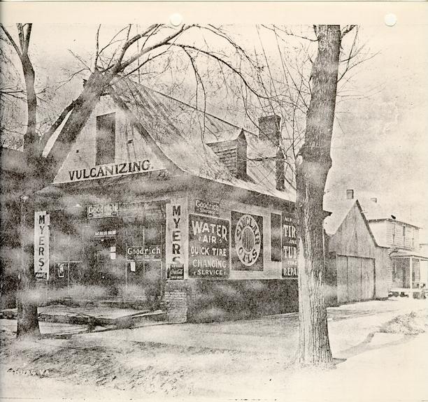 Plate I - The extant c.1740 Prentis store prior to its restoration, along with portions of modern buildings to the west and north. Photographed from the southeast. N3614
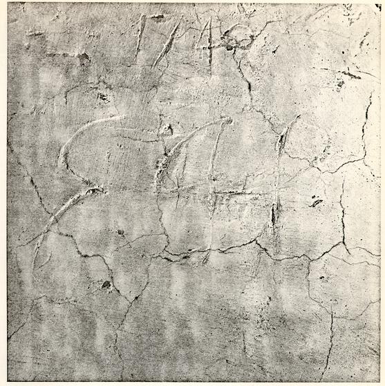 Plate II - Close-up view of the initials and date found on the original plaster, near the peak of the south gable, in the extant c.1740 Prentis Store. 59 JC 321
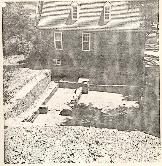 Plate III - Aerial view of the excavated remains of the building known now as the "Archibald Blair Storehouse." The c.1740 Prentis Store is in the background. Photographed from the west. W 2la-6646A
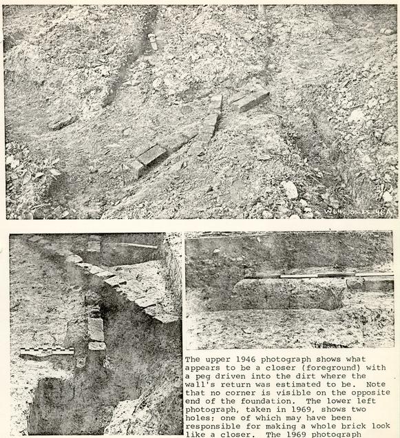 Plate IV - Photographic comparison of Structure c in 1946 and 1969. The upper 1946 photograph shows what appears to be a closer (foreground) with a peg driven into the dirt where the wall's return was estimated to be. Note that no corner is visible on the opposite end of the foundation. The lower left photograph, taken in 1969, shows two holes; one of which may have been responsible for making a whole brick look like a closer. The 1969 photograph in the lower right shows the rather large rectangular hole (E.R. 1454M), filled sometime after c.1782, which held the key to Structure C's building date. Top picture photographed from the southwest. Lower left from the west. 70-PH-670. Lower right from the north. 70-PH-660.
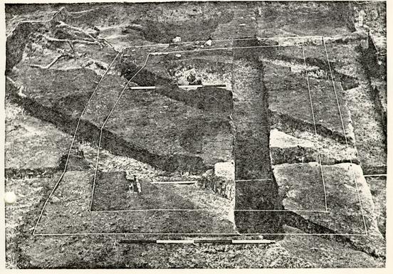 Plate V - Robbed wall trenches (prior to excavation) of Structure D. The darker areas near the center were the ashes which had been-deposited.before this building was constructed. Photographed from the west. 70-PH-661
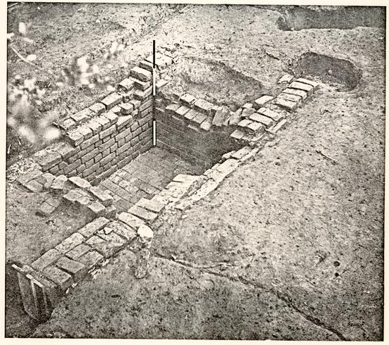 Plate VI - Aerial view of Structure E whose utilization remains a perplexing question mark. Note the existence of wall extensions to the north and south on the feature's westerly foundation. Photographed from the northwest. 70-PH-667
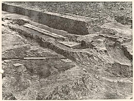 Plate VII - Short section of Structure F's original north wall along with brick paving which presumably serviced that building. The walkway was's'ubsequently covered when an addition was erected onto the main structure. Photographed from the northwest. 70-PH-669
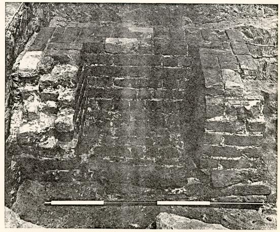 Plate VIII - Substantial chimney foundation which stood on the west wall of the nineteenth-century pier-supported Structure H. The bricks had been reused from another earlier building since traces of oyster-shell mortar were detected on many of them and the scorched bricks were not confined to the feature's burning area but were also found protruding outside the foundation's walls. Photographed from the east. 70-PH-658
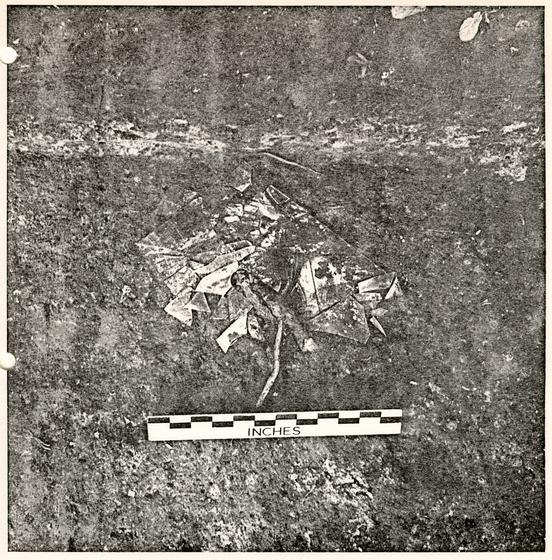 Plate IX - Fractured blue-green crown pane which could have been meant for a sash or shop display window. The fragments were discovered just north of Structure D. Photographed from the south. 70-PH-662
 Plate X - The remains of two levels of paving found just inside the property's southerly fenceline. The marl stratum (lowest level in the section) overlay the earlier brick walkway. Photographed from the north. 70-PH-659
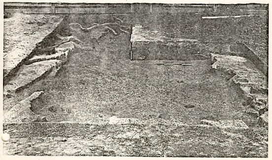 Plate XI - Large rectangular pit with no apparent purpose whose artifacts suggested a post c.1760 filling date. Note that some of the edges were cut straight and consequently did not suffer from erosion. The post holes, visible inside the feature, were modern. Photographed from the east. 70-PH-671
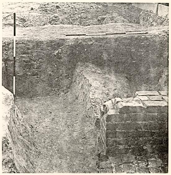 Plate XII - Section of the notth/south trench which may have been dug to obtain clay for a brick-making project. The clay deposit near the center of the feature was part of the original filling but that to the left of it: was redeposited after a previous archaeological excavation. The brickwork in the foreground is part of Structure H's chimeny. Photographed from the north. 70-PH-664
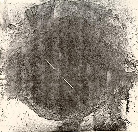 Plate XIII - Aerial view of Well B's shaft after the 1969 excavation. The digging reached a depth of 12'6" before the lining was encountered and, since the bricks were modern, the shaft was not excavated below a point some 8" lower. 70-PH-665
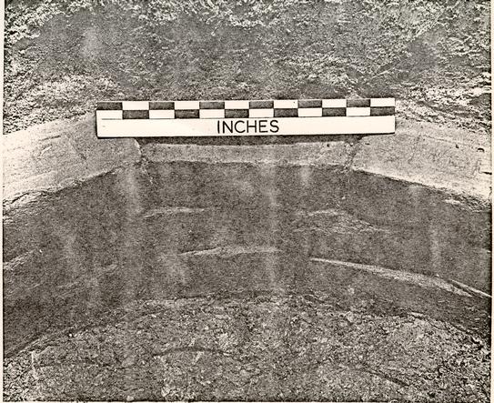 Plate XIV - Close-up view of Well B's lin ing. The regular shaped bricks were laid as stretchers, construction which differs greatly from the typical eighteenth-century methods. Note the initials "W B C" on the upper surfaces of the bricks. 70-PH-666
Figure 16 - Prentis Site Key Plan - oversized image