Willie Baker House (528 Tyler Street) Archaeological Report, Block 45-1 Building 39Originally entitled: "Excavations at the Willie Baker House 1977 Block 27 Area E"
Colonial Williamsburg Foundation Library Research Report Series - 1521
Colonial Williamsburg Foundation Library
Williamsburg, Virginia
1990
EXCAVATIONS AT THE WILLIE BAKER HOUSE
1977
Block 27 Area E
| Figure 1.A Portion of the Frenchman's Map Illustrating the property in 1782 | following p. 2 |
| Figure 2.Site plan | in rear envelope |
| Figure 3.Section of Bulkhead "A" | following p. 9 |
| Figure 4.Section of Bulkhead "B" | following p. 10 |
| Figure 5.Section across rear of building | following p. 14 |
| (Architectural drawings in rear of envelope) |
| Plate I. | Bulkhead "A" |
| Plate II. | Bulkhead "B" |
| Plate III. | East chimney foundation |
| Plate IV. | Northwest chimney foundation |
| Plate V. | Post holes for back stoop |
| Plate VI. | Slot for plank walkway along north wall |
| Page | |
| List of Figures and Plates | i. |
| I.Introduction | 1. |
| II.Historical Background | 2. |
| III. The Excavations | |
| The Cellar | 6. |
| The Bulkheads | 9. |
| Later Additions | 12. |
| Walkway and Stoop | 13. |
| Other Features | 15. |
| IV. Conclusions | |
| Phasing Summary | 16. |
| Interpretation | 17. |
| Recommendations | 17. |
| Appendices | |
| A. List of E.R. Numbers in Text | 20. |
| B. Architectural Samples |
I. INTRODUCTION
When the wooden frame "Willie Baker" house was demolished early in 1977, members of the departments of Architecture and Archaeology examined the newly-exposed foundation. A cellar below the main unit of the house was tentatively dated to the mid-18th century (see monthly report for February, 1977). It was therefore decided that architectural recording and limited archaeological investigation would be necessary before the site could be backfilled. The structure was located in Area F of Block 27, on the north side of Nicholson Street.
The architectural drawings and photographs were completed in October, 1977, and excavations commenced November 7. The original intent was to examine four points of interest: two areas where blocking of the cellar wall indicated an infilled bulkhead, the junction of a west wing to the main unit, and standing chimney foundations along the east wall. It soon became apparent, however, that the complexity of the structural sequence necessitated an expanded archaeological program. Consequently, it was decided to excavate along the north and west walls of the cellar where the soil had been left largely undisturbed since the mid-19th century. Once the archaeological work was finished, any extant stratigraphy would be permanently damaged or removed by subsequent landscaping and soil tilling for sodding or seeding.
The excavations at the Willie Baker house have provided data to establish at least a framework for the reconstruction of its history. The extremely limited nature of the investigation unfortunately precluded any work being done on outbuildings and improvements of the colonial lot. Similarly, a major question 2. was left unanswered when small test trenches at the northwest and southeast corners of the present foundation failed to yield evidence of earlier walls. The Frenchman's Map (ca. 1781) indicates a tripartite building, one of the divisions of which is most probably the Baker cellar.
The research for the 1781 structure and the investigation of the remainder of the property must wait, however, until decisions are made concerning the future development of Nicholson Street, and funds for a full-scale excavation are made available. Immediately after the end of the excavations, all archaeological trenches were backfilled, and soon thereafter the Department of Architecture caused all the old foundations, both 18th and 19th century in origin, to be preserved by filling in the cellar and covering the ruins with a three foot high mound of soil.
II HISTORICAL BACKGROUND
Summary. (From the 1955 Research Report on colonial lot 271 by Mary Stevenson).
In 1713 the trustees of Williamsburg conveyed the lot to Christopher Jackson. John Pasteur, perukemaker, was a French Huguenot who arrived in Virginia in 1700. He was conveyed the lot in October, 1714 by the trustees of Williamsburg and died in 1741. The next owner was William Prentis who held a mortgage on the property until 1746 when George Charlton, a tailor, became the owner. At Charlton's death in 1749, the property came by bequest to his wife, Lydia Charlton. Mrs. Charlton lived thereon until her death in 1760 when she bequeathed the property to the sons of Mrs. Christian Burwell naming John Blair, Jr. as trustee. In 1767 Peachy Davenport became the owner via
 FIGURE 1 . . . Detail from the FRENCHMAN'S Map 1782
3.
the Charlton heirs. While Peachy Davenport (and her husband, Alexander Purdie) owned the property, the valuation increased from 130 pounds, current money of Virginia, to 275 pounds, which seems to indicate that they made major changes either by new buildings or extensive repairs. In 1773 Nicholas Scovemont had come into ownership via Purdie and his wife. Scovemont's son-in-law, Alexander Kevan, was the next owner, acquiring it in 1788 via Scovement. However, the title probably never was in fee simple, for Scovemont, according to the Williamsburg Land Tax records, apparently was still the owner until 1805, at which time Peter De La Croix's estate obtained the property via Scovement. De La Croix's estate continued as owners until 1820 when the name disappears from the Land Tax records. During the Civil War, the James City County and General Court records were destroyed by fire. Such loss leaves a gap in the chain to title of property recorded in these courts until ca. 1865. According to the Land Book of Williamsburg, the estate of John Morris is charged with one lot with buildings thereon in 1865. This property was conveyed in 1869 to Pauling Hill who bequeathed it to her daughter who married Frank D. Banks. Mrs. Banks in 1893 conveyed to Lydia M. Jones. Following several deeds of trust in 1924, Lydia Jones sold the property to William H. Hayes. In 1928 Hayes conveyed to William H. Baker. The northern part of the lot was sold by Hayes to Baker to Mr. Fred Epps, whose widow still occurred this portion of the lot in early 1978.
FIGURE 1 . . . Detail from the FRENCHMAN'S Map 1782
3.
the Charlton heirs. While Peachy Davenport (and her husband, Alexander Purdie) owned the property, the valuation increased from 130 pounds, current money of Virginia, to 275 pounds, which seems to indicate that they made major changes either by new buildings or extensive repairs. In 1773 Nicholas Scovemont had come into ownership via Purdie and his wife. Scovemont's son-in-law, Alexander Kevan, was the next owner, acquiring it in 1788 via Scovement. However, the title probably never was in fee simple, for Scovemont, according to the Williamsburg Land Tax records, apparently was still the owner until 1805, at which time Peter De La Croix's estate obtained the property via Scovement. De La Croix's estate continued as owners until 1820 when the name disappears from the Land Tax records. During the Civil War, the James City County and General Court records were destroyed by fire. Such loss leaves a gap in the chain to title of property recorded in these courts until ca. 1865. According to the Land Book of Williamsburg, the estate of John Morris is charged with one lot with buildings thereon in 1865. This property was conveyed in 1869 to Pauling Hill who bequeathed it to her daughter who married Frank D. Banks. Mrs. Banks in 1893 conveyed to Lydia M. Jones. Following several deeds of trust in 1924, Lydia Jones sold the property to William H. Hayes. In 1928 Hayes conveyed to William H. Baker. The northern part of the lot was sold by Hayes to Baker to Mr. Fred Epps, whose widow still occurred this portion of the lot in early 1978.
Commentary.
John Pasteur was undoubtedly the builder of the cellared structure on lot 271, as he lived there for nearly three decades. 4. It is possible that the cellar was built by 1716, as the act of 1705 dictated that an owner much erect a dwelling within twenty-four months or the property would revert to the city. It is not known, however, if this statue was severely enforced. The next owner/ occupant was George Charlton, followed by his widow, Lydia Charlton. He was a tailor, and appears to have used the property as both home and shop, for the inventory made upon his death in 1749 lists heaters and flat irons, pressing irons, a "Taylors Work board" and four pairs of shears, as well as quantities of cloth and thread. The inventory following his wife's death in 1761 lists no tailoring tools or materials, and it would seem that she did not continue the business. The survival of not one, but two inventories, spanning a twelve year period in the middle of the 18th century, makes the site history particularly interesting, and of added potential for future research.
While the earliest owners of the property have much to tell us of the times in which they lived, so too do some of the latest owners. The house was owned and occupied by Negroes soon after the War Between the States, when it was bought by Pauline Hill at auction in 1869. In the 1880 U. S. census, the Georgian-born woman was described as mulatto, age 34, single, and a school teacher. Eleven years earlier, when she acquired the property, Pauline Hill had an infant daughter, Dixie C. Lumpkin. This illegitimate child eventually married Frank D. Banks, and the couple finally sold the property to Miss Lydia Jones, who is still remembered as "Aunt Lydia" by older members of the Williamsburg Black community.* Lot 271, therefore, was owned by Blacks 5. for more than a century, that is, over a third of the time since the property was first laid out.
Structure alterations and new erections of buildings on lot 271 may be indicated by changes in the property value. In 1735, Pasteur mortgaged his holding for almost 94 pounds. Eleven years later, George Charlton paid 130 pounds for the property but apparently did not improve it, because Peachy Davenport paid the same price in 1767. When the property was bought by Nicholas Scovement, however, its value was 275 pounds. This 1773 price surely indicates major rebuilding or additions, and most probably reflects the erection of those structures appearing on the Frenchman's Map (see Figure 1). With the Scovement ownership, the records become much less secure, but it seems that the original structure was replaced by the one pulled down in 1977, the exchange occurring perhaps in the 1840s. In the research report for lot 272 (by Mary Stevenson, 1955, Illustration #2), the pertinent Williamsburg land tax records state that in April, 1842, the buildings on the lot were totally destroyed by fire. It may be that the house on lot 271 was damaged during that same fire, and the fact simply unrecorded. Alternatively, it has been suggested by Mr. Paul Buchanan that the Research Department lot designations for the north side of Nicholson Street have been misapplied. He believes that lots were wider along the outside of the side streets than elsewhere in town, and that this factor could mean that the Baker House stood on colonial lot 272, not 271. A cursory comparison of the two lot histories suggests, however, that the archaeological sequences follow the recorded information for 6. lot 271, while failing to correlate with any dating for lot 272. Moreover, no evidence was found for the fire of 1842, even upon those foundations of the original structure which were reused by the 19th century Willie Baker House and are still standing.
III THE EXCAVATIONS
The Cellar.
(See architectural drawings in rear envelope)
The 16' 0" by 28' 0" cellar was the earliest structure found in the excavations (see Figure 2). A gray sandy loam had been the soil level at the time, as it was cut by the cellar construction trench and had been covered in places by a spreading yellow clay from the digging of the cellar hole. Where tested, the gray sandy loam (E.R. 2159R-27.E.) contained artifacts, including an Indian pipe dating to the end of the 17th century and the first decades of the 18th century. These finds suggest that some occupation of the site had taken place before the cellar was built, because the mixed clay fill of the builder's trench for the north wall (E.R. 2158N-27.E.) yielded a fragment of English delftware generally attributable to ca. 1720-30. On the north and west sides of the cellar, the builder's trench was 1' 6" wide, with vertical sides, but at the southeast corner (E.R. 2163M-27.E.) it was found to be about 7" wide, sloping inwards.
The cellar was orientated east-west, lying about 6' 6" north of the Nicholson Street boundary established by the Waddell Survey. Its north wall was 3" shorter than the south wall which made the east wall lie at a slight angle. All the cellar walls were one-and-one-half bricks thick (1'2") until the level of the old ground surface, where they were reduced to a single brick width (9-½"). The walls stood 6'9" high, with the ground level offset at 5'0" at the ends, and 5'3" on the sides (twenty-one and twenty-two courses, respectively, of a total of twenty-eight).
7.The Cellar Floor.
A modern concrete floor covered the bottom of the cellar everywhere except beneath the eastern chimney foundation (E.R. 2167-27.E.). At seven courses from the bottom (1'8"), as change was noted in the brick coloration, especially along the north and west walls. The stain indicated that the cellar floor had been raised sometime after its original construction, but lowered to coincide with the insertion of the concrete floor.
Examination of the interior face of the blocking of Bulkhead "A" showed that while the rest of the bricks were mortar joined, there was only soil between the lowest seven courses. This suggests that the blocking of Bulkhead "A" took place simultaneously with the raising of the cellar floor.
The Cellar Windows.
The wall facing Nicholson Street contained two windows, each 3'0" wide, and centered 7'0" from the exterior corners of the cellar. Both rose through the five courses of the 3'0" high above-ground foundations, which would mean that the windows were originally 3'0" square.
The western window had been blocked, perhaps in the 19th century, because the shell mortar of the blocking was thinner and more grainy than that used on the cellar walls, and it was comprised of brickbats, some of which were blackened on one side, perhaps reused from a chimney (for mortar and brick comparisons, see Appendix D). The bricking up of the western window should have occurred at the same time as, or later than, the construction of the west wing (see below p16), because its location would put it near the center of the expanded building where a doorway must have been inserted some time before the construction of the modern stoop.
8.The eastern cellar window appeared to have never been blocked. At the time of the Baker House's demolition, what was believed to be the original wood sill was found, drawn, and removed by members of the Department of Architecture. Such an attribution may be questioned, however, because the drawings made at the time show that it lay one course below the bottom of the western window, and there, one course into the thick cellar walls, where much disturbance of unknown date has taken place.
The Vault.
The northeast corner of the cellar was constructed with a barrel vault springing from the top of the nineteenth course, or a height of 4'5". Only the single row forming the base of the vault remained, and that survived for only 8'7", being destroyed on the east by the insertion of Bulkhead "B," and ending on the west at a modern cut 2'8" wide through the wall. Mr. A. E. Kendrew, who kindly examined the cellar walls, believes that the arch was probably segmented and that the vault would have extended about half way across the interior of the building, forming a "wet" cellar within one part of a "dry" cellar.
An unusual feature of the vault was a supporting rib or buttress, the east side of which lay 10'1" from the northeast interior corner of the cellar. The buttress was 1'6" wide and had been demolished back to the wall line except for the lowest five courses which extended 1'0" out from the wall. The fronts of all the bricks had been damaged, but it is difficult to imagine this feature having extended further into the cellar. The vault would have continued some distance west past the buttress, more than the extant 3'5" but less than 5'10" where a blank wall still stands. Because the bottom few courses of the north wall were 9. intact everywhere except in modern cutting, it could be determined that another buttress had never been built along the wall. More definitive information concerning the vault will have to wait until full-scale excavations take place. Then the concrete cellar floor should be taken up, the east chimney removed, and the wall behind it exposed.
Bulkhead "A."
The cellar was originally entered from the southwest where a bulkhead had been cut into the natural clay. This feature had an exterior width at least 5'9" and took a step at least 4'0" wide (see Figure 3). It extended 5'8" out from the wall, and had five steps, including one sealed beneath blocking masonry and one at the old ground surface, 4'2" above the cellar floor.
The bulkhead had been dismantled and blocked (see Plate I); tips of ash and household rubbish had then been deposited with the hole. These layers (E.R. 2156h, J, K-27.E.) yielded material typical of the mid-eighteenth century, and fragments of at least nineteen wine bottles formed the bulk of the finds. The south wall of Bulkhead "A" could not be located. It may have took south of the cellar corner, or had been totally destroyed by the west wing foundation trench (E.R. 2156F-27.E.) and possible post hole (E.R. 2156L-27.E.) at that corner.
Bulkhead "B."
Cutting through the north cellar wall, Bulkhead "B" was a secondary construction, replacing Bulkhead "A." It was 5'0" wide on the exterior, and 3'7" wide on the interior (see Figure 4). Bulkhead "B" had also been dismantled and blocked, but with an unusual sequence (see Plate II). At the bottom of the bulkhead
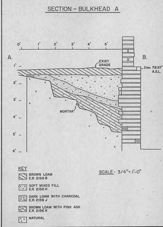 FIGURE 3...SECTION - BULKHEAD A
10.
was a 5" deep deposit of mortar lumps (E.R. 2164C-27.E.) evidently from its destruction, as the mortar covered the few brick fragments still in situ. A gray loam filled the remainder of the bulkhead hole. It was indistinguishable from the fill of pipe trenches which cut through the area. The loam (E.R. 2160B-27.E.) contained a U.S. penny minted in 1881, and numerous fragments of a set of dishes, the maker's mark for which dates to 12 February 1883. This deposit is of particular interest to the history of the site because it contains a group of artifacts which was most probably the household debris of a black occupant, Miss Lydia Jones, who bought the property in 1893 (for the historical background, see page 2).
FIGURE 3...SECTION - BULKHEAD A
10.
was a 5" deep deposit of mortar lumps (E.R. 2164C-27.E.) evidently from its destruction, as the mortar covered the few brick fragments still in situ. A gray loam filled the remainder of the bulkhead hole. It was indistinguishable from the fill of pipe trenches which cut through the area. The loam (E.R. 2160B-27.E.) contained a U.S. penny minted in 1881, and numerous fragments of a set of dishes, the maker's mark for which dates to 12 February 1883. This deposit is of particular interest to the history of the site because it contains a group of artifacts which was most probably the household debris of a black occupant, Miss Lydia Jones, who bought the property in 1893 (for the historical background, see page 2).
Thus, Bulkhead "B" was constructed by the middle of the 18th century, but the filling of its hole took place in the late 19th or early 20th century, while the north wing, it will be seen, was built over it in the middle of the 19th century. The brick infill was a standard size, with no brickbats or reused bricks, and its mortar was late (see Appendix B). The fact that mortar from the destruction of the bulkhead was found only at the very bottom of the hole suggests that there may well have been an interval between the destruction of Bulkhead "B" and the bricking up of the cellar entrance there, accompanied by the dumping of household debris into the hole.
Bulkhead "C" and East Chimney.
Although later modified by the insertion of concrete steps, Bulkhead "C" represents the latest intrusive entrance to the cellar, this time on the east side of the house. The south face of the 2'1" wide entrance was the chopped-through original cellar wall, against which was built the south bulkhead wall. Excavations
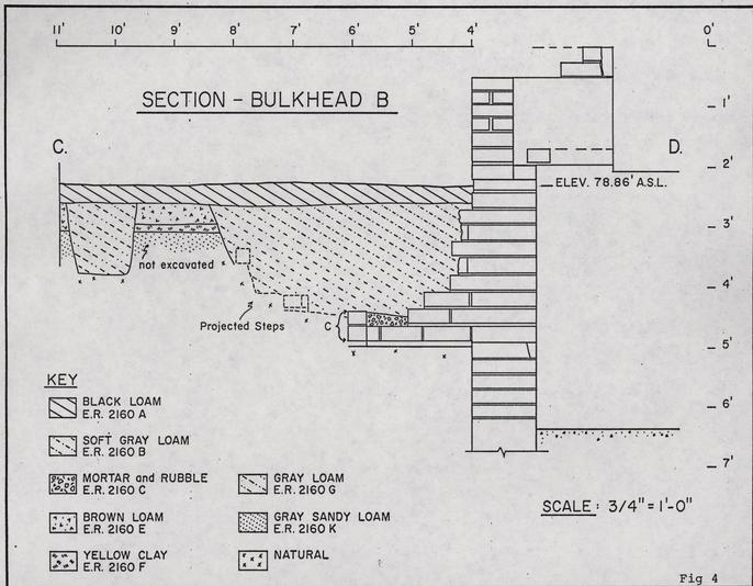 FIGURE 4...SECTION- BULKHEAD B
11.
at this junction exposed the bulkhead foundation trench (E.R. 2163C-27.E.) as well as the cellar foundation trench (E.R. 2163M-27.E.). The north face of the opening was rebuilt as part of the chimney foundation simply butted against the cellar wall.
FIGURE 4...SECTION- BULKHEAD B
11.
at this junction exposed the bulkhead foundation trench (E.R. 2163C-27.E.) as well as the cellar foundation trench (E.R. 2163M-27.E.). The north face of the opening was rebuilt as part of the chimney foundation simply butted against the cellar wall.
The area between the east chimney foundation supports had been left untouched when the cellar floor was lowered during the installation of concrete flooring. This area was sealed by brickwork from the blocking up of the chimney foundation for its adaptation as an outlet for a furnace flue. A modern mortar base for this construction work sealed a group of brickbats roughly laid upon a thin bed of yellow mortar (E.R. 2167F-27.E.) evidently the remains of a once extensive brick floor (see Plate III). It was 1'3" above the old floor level, about the same as the stain noticed around the sides of the cellar. Within the mortar layer were numerous pieces of wall plaster, as well as an intact clay wig curler. The mortar lay upon an 11" thick deposit of mixed brown loam (E.R. 2167G-27.E.), which was found to contain more pieces of wall plaster, as well as clinker and iron waste. The loam also yielded pottery dating to the middle of the 19th century. It is quite likely that the material found at the base of the east chimney did not represent a deposit cut and sealed by the erection of that structure. Rather, the notable absence of a wide construction trench suggests that the entire deposit was a builder's hole, and that the brick flooring, and the loam beneath it, was the replacement for a cellar floor removed where the east chimney was inserted.
The West Wing.
Near the middle of the 19th century, a 10'6" by 16'0" addition was made to the west end of the original building (see Plate IV). The foundation trench for this feature cut through 6" thick layers of trash and oyster shells containing early 19th century potter. The 9" wide walls continued the floor level of the original structure, having a soldier course as their uppermost brick course to ensure a level foundation. At the center of the wing's west wall stood as contemporary chimney base, extending 1'9" from the wall, with supports 1'2" wide and 3'2" apart.
A coating of whitewash was partially preserved on the exterior face of the cellar's west wall. It is unlikely that it dates from the Bulkhead "A" period of the house, having been subsequently covered and protected by the extension represented on the Frenchman's Map. Rather, the build-up of soil in the early 19th century suggests that the ground immediately west of the cellar was open to trash dumping and that this process stopped only when the present west wing was added. Therefore, the whitewash should date to that time when the ground was open and the wall exposed to weather.
The North Wing.
A 16'3" by 15'11" addition had been made to the north wall of the cellar. This north wing was built on brick piers and had a chimney on the far end. The piers were built to the same height as the cellar walls, so the floor level in the house would have remained the same. The chimney foundation measured 4'7 " x 2'3", and added to the front was a roughly built hearth base, 4'7" x 2'0". Buried soil (E.R. 2161F-27.E.) found beneath the chimney yielded fragments of "anular ware," made early in the 19th century.
13.The Northwest Chimney.
Testing outside the northwest corner of the cellar revealed the foundations of yet another chimney. It was brick built, with shell mortar, and it cut down into ash (E.R. 2157M-27.E.) containing creamware sherds, a type of pottery not recorded in Williamsburg before 1769. The foundation measured 4'9" x 2'6" and lay along a line extending north from the cellar's west wall (see Plate IV). An additional brick was attached at the southeast corner, while a two-brick gap occurred at the northeast corner, suggesting that a north-south wall tied into the chimney foundation at those points. Unfortunately, crossing the area was a series of post holes from both before and after the life of the chimney. It seems that garden fences commonly ran north from the northwest corner of the cellar. Excavations were too limited to establish the position of the structure associated with the northwest chimney. It seems probable, however, that it was part of the structures recorded on the Frenchman's Map.
The Walkway.
First observed immediately to the west of Bulkhead "A," a deposit of brickbats formed a linear pattern leading to the northeast, where it was cut by the north wall of the west wing, continuing around the corner of the house (E.R. 2156T, 59L, 57R-27.E.). These bricks were more concentrated to the south, but clearly followed the line of a clay filled slot-like feature (E.R. 2159N-27.E.) which cut through the edge of the cellar construction trench (E.R. 2159P-27.E.). It has been conjectured that the bricks and the 3" deep clay deposit beneath them represented a walkway and its seating trench. A similar linear feature (E.R. 2165M-27.E.) was found running east-west 3'2" to 5'0" out 14. from the cellar's north wall (see Figure 5). The fill was a soft gray loam without any brickbats, with a fairly even depth of 2"- 3" (see Plate VI). It is unlikely that the slot was a robbed brick path because at least some brick particles would normally be left behind. It is possible, however, that the plank walkway skirted the rear of the house, and upon approaching the much used cellar bulkhead, was replaced by a brick path which probably continued toward the street. It should be noted that a substantial deposit of kitchen rubbish was found to the west of the brick line. This would have caused a rise in the soil level which may have necessitated the raising of the walk for better drainage, and the replacement of planks with bricks.
The Back Stoop.
Three post holes with molds were found on the west side of the cellar's north wall, the fourth hole presumably having been destroyed during the modern cutting into the cellar wall (see Plate V). The plan of the surviving holes shows that they formed a rectangle. The holes averaged 10" by 11," and the molds were 6" by 6" and about 10" deep. They would have supported timber uprights for a stoop 5'10" wide and extending 4'7" north of the building. The stoop showed no geometric relationship with the original structure, but it did stand at the exact mid-point of the expanded house with the west wing, indicating that the stoop was constructed when the west wing was added.
The holes cut through the fill of the north slot (E.R. 2165M-27.E.), and therefore were dug after it was no longer in use. One of the molds (E.R. 2165N-27.E.) was filled with cinders; the destruction of the stoop was therefore later than the build-up of cinders and clinker along the north wall. The clinker layer
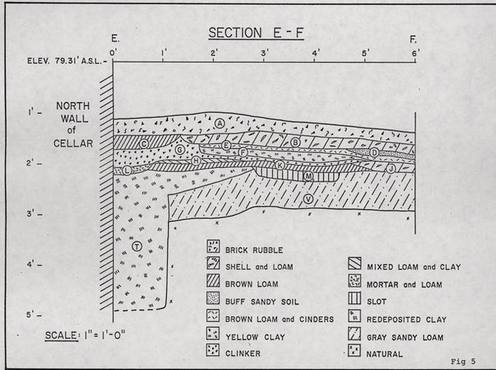 FIGURE 5... SECTION E-F
15.
was followed by the erection of the north wing, an action which probably coincided with the removal of the stoop, as the west side of the north wing lies on the same line as the east side of the stoop.
FIGURE 5... SECTION E-F
15.
was followed by the erection of the north wing, an action which probably coincided with the removal of the stoop, as the west side of the north wing lies on the same line as the east side of the stoop.
Other Features.
A soft sandy soil filled a small linear feature (E.R. 2158F-27.E.) which lay 4'3" from the cellar wall. It was 1" deep and 1'4" wide, with sloping sides. This feature has been interpreted as a drip line caused by rain running off a gutterless roof. It may have been associated with the stoop, as it ran along the same line as the outer post holes. It appeared to extend past the stoop in both the east and west, however, such an association is tentative only.
The west edge of Bulkhead "B" cut through a feature which abutted the cellar north wall (see Plate VI). This feature (E.R. 2164F-27.E.) extended 2'7" out from the wall and was 7" deep, with a flat bottom. The remaining area of fill contained brickbats and mortar lumps. Several unmortared bricks stood against the feature's western edge, forming a crude soldier course rising above the level of the fill. It is believed that the soldier course was placed up against brick footings which were later robbed, leaving the rubble fill in the hole. Because the robbed hole was cut by Bulkhead "B," the footing may be associated with the Bulkhead "A" period of the house. The robbed foundation and its associated soldier course are probably related to an original rear entrance to the building, but the exact relationship cannot be determined at the present.
IV CONCLUSIONS
Despite the limited nature of the excavations at the Willie Baker House, a relative chronology could be established throughout the investigated area. Many of the structural changes could be put into sequence, though more exact dating proved impossible. Nevertheless, we have been able to answer most of the questions which were posed when the foundations were first revealed.
Phasing Summary
- 1.Construction of cellar, vault, and Bulkhead "A." (Pottery in builder's trench as early as c. 1720?)
- 2.Foundation robber hole and soldier course against north wall; possible side stairs to stoop.
- 3.Pathway composed of brickbats by west wall and planking by north wall.
- 4.
- a.Destruction of Bulkhead "A." (Sealed group of artifacts no later than 1750s.)
- b.Construction of Bulkhead "B."
- c.Destruction of vault.
- d.Raising of cellar floor level.
- 5.Erection of the northwest chimney and associated structure (later than deposit containing creamware, post 1750).
- 6.Destruction of the northwest chimney (ca. 1800?).
- 7.Erection of west wing, north stoop, blocking of southwest cellar window (ca. 1820?).
- 8.Erection of east chimney and Bulkhead "C" (ca. 1845?)
- 9.Erection of north wing; destruction of Bulkhead "B," but cellar hole kept open. Possible interior steps from north wing (ca. 1845?).
- 17.
- 10.Blocking up of interior Bulkhead "B," filling in of hole (post 1883).
Interpretation.
When the wooden superstructure of the Willie Baker House was demolished, specific questions were raised about the exposed brick remains (i.e., three bulkheads, three chimneys, two wings, and a cellar vault. These questions have been addressed in the body of the text, as fully as possible given the limited nature of the excavations. The house site proved to have had a long history, one of many changes and at least one rebuilding which turned a one story colonial house into the two story building occupied by Willie Baker. The archaeological evidence suggests that a major reconstruction may have taken place in the second quarter of the 19th century, unfortunately during the thirty year gap in the documentary history of the site. At that time, the building was expanded to the west, and the positions of the doorways shifted to center on the new length. The eastern chimney may have been built at this time or perhaps a little later, and with it were added the east bulkhead and the north wing. In the 20th century there were minor additions, but the core of the house remained early Victorian, probably anti-bellum at the time of its demolition in 1977.
Recommendations.
The work done at the Baker House in November, 1977, has brought to light a great deal of information about the history of that building. Because areas along only two sides of the structure were examined in detail, there remains much to discover, e.g., the original structure's chimney and front entrance. Much of the ground uncovered during the excavations had been relatively 18. undisturbed, and one may expect that the rest of the site would be in the same state because until 1977, the property had not been archaeologically explored. It remains one of the few such sites in Williamsburg, and one of the most important of them with a fine cellar and hopefully undisturbed stratigraphy surrounding the colonial outbuildings. The documentary history of the property is especially rich in the 18th century; inventories for two of the owners detail the goods and furnishings of the house in 1749 and 1761. Any development of the Nicholson Street property should take into consideration the architectural, archaeological, and historical potential of the site originally built by John Pasteur in 1714.
An additional comment must be made concerning the more recent ownership of the house. It is certain that in the late 19th century, the property was owned by blacks, and it is probable that their acquisition of the lot took place shortly after the American Civil War. If this transfer can be firmly established, then the Willie Baker House would have had a century of Black occupation. Any archaeological work on the property must bear this in mind. Little has been recorded of the customs or culture of Virginia blacks within a generation of their emancipation, particularly those of substance enough to own and maintain a good sized house. It is likely that future archaeological investigation at the Willie Baker House will unearth those tools, household goods or luxury items, upon which some areas, at least, of Virginia blacks' culture can be assessed. This property, then, is unique, having owner and occupants of such diverse times and origins as the first builder, John Pasteur, a 17th-century 19. Huguenot refugee, and the last owner, Willie Baker, a member of 20th-century Williamsburg's Black community.
Footnotes
APPENDIX A
| Excavation Register (E.R.) Number | Description of Feature of Layer and Date of Fill. |
|---|---|
| 2156F | Builders trench for west wall, 6" wide. All have soft loam with mortar. (19th century). |
| 2156H | Soft mixed fill of bulkhead. Uppermost layer, light brown loam. (Colonial). |
| 2156J | Soft gray loam with charcoal bits, slopes down towards bulkhead, second layer of fill, lies below 2156H, 3" thick. (Post 1750). |
| 2156K | Pink ash with light brown loam, lies below 2156J, third layer of bulkhead fill. (Post 1730). |
| 2156L | Dark brown loam, with some mixing in cutting below wall trench 2156F, 9" deep 1'10" wide, cuts 2156J. (No finds). |
| 2156T | Brickbats in loam - path? (Post 1730). |
| 2157M | Layer of mixed gray ash and pink ash. Same as 2157J only the pink ash of 2157J is intermixed with the gray ash. The hearth appears to cut the pink ash. The pink ash is also sealed by the oyster shell of 2157H. (Post 1770). |
| 2157R | Scattering of brick with an ashy loam matrix. Bricks align with the bricks in 2156H and 2159L, forming a line running S.W. to N.E. (Post 1740). |
| 2158F | Linear depression, ?drip line, sandy yellow soil, similar to 2158C, and directly below it, 1" thick, about 1'4" wide, entire width of trench. (Post 1785). |
| 2158N | Redeposited clay, builder's trench, sealed by 2158M. (Post 1720). |
| 2159L | Layer of brickbats in line running N.E.-S.W. Some charcoal, gray loam, but mainly patchy yellow clay, lies below 2159K. Badly cut up by rat holes. (Colonial). |
| 21. | |
| 2159N | Yellow clay redeposited, on line outside of builder's trench. ?Related to bricks, possible path, as lies below. Could be seating for it, cuts gray sandy loam. (Colonial). |
| 2159R | Builder's trench for cellar. Mixed clay fill, 1'6" wide, sealed by 2159M, gray loam. (Colonial). |
| 2160B | Soft gray fill of hole outside northeast corner of building, for pipe? (Post 1883). |
| 2161F | Dark loam below 2161E, sealed by construction of chimney, therefore precedes wing of building only partially removed. Lies upon a gray sandy loam, 3" thick. (19th century). |
| 2163C | Large brick and loam fill, 8" wide, runs parallel to cellar well steps. (19th century). |
| 2163M | Builder's trench for cellar, 7" wide, increasingly narrow. Could not be fully excavated. (No finds). |
| 2164C | Soft mortar rubble in bulkhead, 5" deep. (Colonial). |
| 2164F | Layer of mixed loam and clay, brown and yellow, lying above (cut into) the cellar construction trench and cut by the bulkhead construction trench. 7" deep. Runs under and between the brick footing, sealed by 2164A. (Colonial). |
| 2165M | Slot with soft gray loam fill, cuts yellow clay spreads, sealed by 2165K. 2" - 3" deep, lies 3'1"-5'0" out from wall = 2158J. (Colonial). |
| 2165N | Post mold against wall, clinker in fill. 6" x 6" x 9" deep, related to 2165G, and existed through development of 2165K and H. (Colonial). |
| 2167F | Mortar which lies below the brick, appears to be sealed by it, undercut by rat hole 1-½" thick. (Post 1730). |
| 2167G | Brown mixed fill which lies below the mortar. (Post 1845). |
APPENDIX B
WILLIE BAKER ARCHITECTURAL MATERIAL
27.E.
| 2156H - | red-brown with glaze |
| 2157H - | light red to pink |
| 2157K - | orange |
| 2158J - | light red with glaze |
| 2158M - | glazier fragments |
| 2159M - | pink |
| 2160L - | orange |
| 2160Z - | salmon red |
| 2161 - | gray - 9" x 4-½" x 2-½" - "ELI No. 1" |
| buff - 9" x 4-½" x 2-½" - "REFRACTO" | |
| red - 9" x 4-½" x 2-½" - "MOUNT SAVAGE" | |
| 2162A - | red, some inclusions |
| 2162B - | dark red with glaze |
| 2162D - | orange red |
| 2162E - | orange red |
| 2165K - | dark red, sandy |
| 2168A - | 8-½" x 4" x 2-½" - orange to red |
| 2168B - | 9" x 4-½" x 2-¼" - orange to red |
| 2168C - | 8-½" x 4" x 2-¾" - dark red to purple |
| 2168D - | 8-½" x 3-¾" x 2-¾" - dark red to purple |
| 2168E - | 8-½" x 4" x 2-¾" - dark red, reused? |
| 2168F - | 8-½" x 4-½" x 2" - dusty red to light purple, all similar |
| 2168G - | reused, all brickbats no purple |
| 2168H - | brickbats 2" x 4" x - orange to red, some blackened |
| 2168J - | 8-½" x 4-¼" x 2-½" - dark red to purple |
| 2168K - | brickbats, reused - dark red to purple |
| 2168L - | 8-¾" x 4"" x 2-¼" - orange to red |
| 2158B |
| 2158C |
| 2158E |
| 2158H |
| 2160K |
| 2167G |
| 2159J - | small piece of granite |
ARCHITECTURAL MORTAR & PLASTER SAMPLES FROM WILLIE BAKER HOUSE
27.E.
| 2156R | hard buff; plaster |
| 2156S | light gray with shell |
| 2157D | sandy buff with brick chips |
| 2157G | light gray with shell; plaster |
| 2158 | plaster with white paint |
| 2158C | hard gray |
| 2159B | sandy buff; plaster |
| 2159E | hard gray; plaster |
| 2159F | friable gray, inclusions; plaster |
| 2159G | hard buff |
| 2159J | light gray with shall; plaster |
| 2159K | soft sandy pink |
| 2159P | light gray with shell |
| 2160 | plaster with green paint |
| 2160B | plaster with green paint |
| 2160H | hard buff; plaster |
| 2163D | hard buff; plaster |
| 2163G | hard buff; plaster |
| 2163H | gray with inclusions; plaster |
| 2164F | soft gray |
| 2165C | soft buff with shell |
| 2166D | soft cream with shell; plaster |
| 2166E | hard buff; plaster |
| 2167E | light gray; plaster |
| 2167F | hard buff; plaster |
| 2168A | yellow with shell |
| 2168B | hard gray with shell |
| 2168C | pale yellow |
| 2168D | yellow sandy, inclusions |
| 2168E | yellow with shell |
| 2168F | hard gray |
| 2168G | hard gray |
| 2168H | soft yellow |
| 2168J | yellow sandy |
| 2168K | yellow sandy |
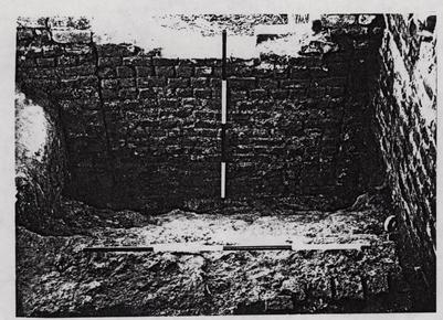 Plate I. View of Bulkhead "A" from the west. Note that the mortar continues up to the brick edging in the foreground.
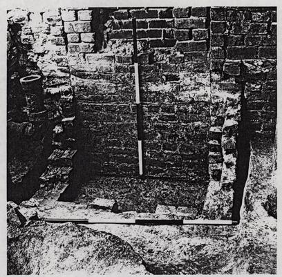 Plate II. Bulkhead "B" from the north, after excavation. Note the four periods of brickwork: the original cellar, along the right side; the bulkhead walls inserted into the cellar; the blocking-up of the bulkhead; and the bricking-in of a window or ventilation hole left within the blocking of the bulkhead.
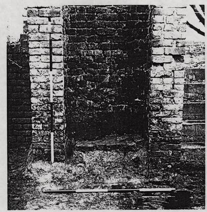 Plate III. The east chimney after the blocking material was removed. Photographed from the west. The remnant of brick flooring survives within the chimney, upon a bed of mortar, and a layer of missed loam fill. The horizontal rod in the foreground is lying upon the modern concrete floor.
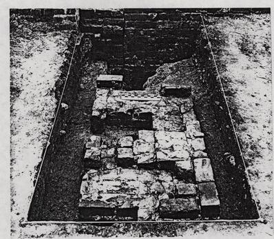 Plate IV. The northwest chimney foundation, after excavation. In the background, not addition of the west wing to the cellar wall. Also note the extra brick course in the far (southeast) corner of the chimney. Photographed from the north.
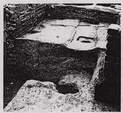 Plate V. Post holes for stoop along north wall in square E.R. 2165-27.E. The slot is E.R. 2165M, possibly for a plank walkway of an earlier period. Photographed from the northeast. Note the builder's trench and buried soil in the exposed section.
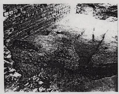 Plate VI. View of area west of the partially excavated Bulkhead "B." Photographed from the northeast. To the right is the plank walkway. Abutting the wall on the left is a crude soldier course of bricks, while along the exposed section is a rubble filled depression (E.R. 2164F-27.E.).
[Portion of large site plan of 1977 Excavations]
[Portion of large site plan of 1977 Excavations]
[Portion of large site plan of 1977 Excavations]
[Portion of large site plan of 1977 Excavations]