1.
Project Background
Introduction
The Colonial Williamsburg Foundation Department of Archaeological Research conducted
a Phase III archaeological investigation of site CG-3, located in James City
County approximately seven miles east of the City of Williamsburg (Figure 1).
CG-3 was assigned state designation 44JC633 by the Virginia Department of Historic
Resources. This tract of land, associated with the property of Carter's Grove Plantation,
has been deeded to James City County for the construction of a public school building.
The purpose of this project was to thoroughly examine a relatively small but intact aboriginal
site that would be impacted by this construction. Sites of this type are generally discounted
as "ephemeral lithic scatters" since little information is known about their importance
and relationship to regional settlement patterns (Blanton 1991).
At approximately 30 meters above mean sea level (amsl), site 44JC633 is situated
atop the eastern half of an elevated landform or ridge located between two major ravines.
The site is positioned just south of existing Route 60 in the Grove Community of James
City County (Figure 2). A prehistoric site, 44JC633 measures approximately 100 square
meters. Laboratory analysis of lithic distribution and site stratigraphy indicates a relatively
intact site. Most evidence of plowing remains above the prehistoric layers. Other soil
processes, like floralturbation have probably taken place in the area. Some basic patterning
of lithic materials, however, revealed through the excavation of small units within a
confined area, seems to suggest an intact site. The site is divided into two loci based on
distinct lithic concentrations and are identified in this report as Locus-1 and Locus-2.
Little evidence of primary, final stage, or maintenance reduction activities were found
during laboratory analysis. Secondary thinning flakes and flake fragments and shatter comprised
most of the debitage. Additionally, tested cobbles, informal groundstones
(hammerstones), an informal tool (utilized flake), hafted bifaces, bifaces, cores, fire-cracked
rock, and miscellaneous unmodified stones were recovered from the excavations. Patterns
of lithic reduction, material types, lack of features, extent of intra-site mending and
refits, and site size and structure, clearly indicate very short-term episodes of occupation
and possibly reoccupation through time. Specifically, this evidence seems to suggest two
limited function encampments in which individuals engaged primarily in intermediate stage
reduction of quartzite cores or bifaces (Locus-1) and more subsistence-oriented activities
(Locus-2). A minimum of 19 distinct blocks of material were reduced in varying degrees at
the site with 36.8% (n=7) at Locus-1 and 63.2% (n=12) at Locus-2.
The Colonial Williamsburg Foundation Department of Archaeological Research conducted
Phase I and Phase II archaeological investigations of site 44JC633 in February,
1991 and from April, 1991 to May, 1991 respectively. The site was first identified during
the Phase II cultural resource survey. Additional, extended investigations of the site were
conducted from June, 1991 to September, 1991. These investigations were associated
with the proposed school construction in accordance with an agreement with James City
2
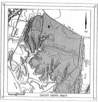 FIGURE 1
Site Location on the Locust Grove Tract of Carter's Grove.
County. The purpose of Phase I and II surveys and Phase III excavation at this site was to
examine the structure and patterns of a small, intact prehistoric site on Virginia's Coastal
Plain.
FIGURE 1
Site Location on the Locust Grove Tract of Carter's Grove.
County. The purpose of Phase I and II surveys and Phase III excavation at this site was to
examine the structure and patterns of a small, intact prehistoric site on Virginia's Coastal
Plain.
Other Archaic and Woodland Period aboriginal sites (Figure 3) are within close proximity
to 44JC633, indicating the area was conducive to hunting and gathering, among
other prehistoric activities. Seasonal occupancy and possibly base settlement of Native
Americans in and around this upper part of the James-York Peninsula appears to have
spanned many generations in time.
This project was directed by J. Michael Bradshaw whose responsibilities included
fieldwork, artifact analysis, and report preparation. David Muraca, Steve Atkins, Beau
Harbin, Gunnar Brockett, and Brad McDonald conducted Phase I and II testing of the
site. Students from the College of William and Mary Summer Field School, Corey Judson,
Audrey Horning-Kossler, Elizabeth Anderson, Mike Jarvis, and Dagmar Von Toal served
as field supervisors and assistants. Mary Clemons, Carol O'Melia, Brian O'Melia, Sandy
3
 FIGURE 2
Project Area and Environs.
(U.S.G.S. 7.5 Minute Yorktown Quadrangle, U.S.G.S. 7.5 Minute Hog Island Quadrangle)
 FIGURE 3
Prehistoric and Historic Site Locations in the Vicinity of CG-3 (44JC633).
4
Bradshaw, Missy Bradshaw, Joseph Robertson, Bill Kossler, Scott Hetrick, Christine
Bowen, Shannon Bradshaw, Robin Fehnel, Dennis Cotner, and Martha Moore worked in
a voluntary capacity as excavators. Laboratory processing of artifacts was supervised by
William Pittman, Amy Kowalski, and Pegeen McLaughlin-Pullins. Analysis of artifacts
was conducted by J. Michael Bradshaw, Pegeen McLaughlin-Pullins, Michael Collier,
and Lisa Youngers. All phases of the archaeology were accomplished under the general
supervision of Marley R. Brown, III, Director of Colonial Williamsburg's Department of
Archaeological Research.
Environmental Setting
Carter's Grove plantation comprises approximately 800 acres situated on the north bank
of the James River, between Grice's Run (which borders the property to the southeast and
Wareham's Run, a little over one mile to the northwest. Carter's Grove centers on a neck
of high ground, separated from the adjoining countryside by ravines and swamps-characteristic
of land well-suited for agricultural activity. The distinct high-ground topographic
feature known as the Kingsmill scarp is an ancient beach head, trending east-west and
fronting onto the James River. This high ground gently slopes to an ancient river terrace
approximately thirty feet above sea level. Most of the direct river frontage from that point
consists of steep, eroded bluffs.
Historically, this particular area appears to have been mostly open farmland, cultivated
over the past several hundred years. Little or no agricultural activity is being conducted in
this area at present. The wooded area in the southern half of the project area is covered by
mixed deciduous and conifer forests of loblolly pine, oak, spruce, fir, cedar and holly, with
an understory of dense honeysuckle, various ivies, and greenbrier. A large logging project
has just been completed to the south of the project area.
The climate is typical of the east-central portion of the Virginia Coastal Plain, where
the average winter temperature is 41 degrees Fahrenheit and the average spring/summer
temperature 76 degrees. The average relative humidity ranges from 80% or less in the
morning to 60% or less in the afternoon. Prevailing winds are generally strong (over fifteen
mph), mostly originating from the southwest.
Erosion appears to have been a significant process in the development of the present-
day topography, with slopes of the scarps receiving the greatest impact. Coupled with
annual plowing, from preceding years, no archaeological material is expected to survive
on any slopes. Natural erosion, particularly in areas along rivers and streams, appears
more substantial than in other regions. Plowed fields left exposed to wind and water processes
were generally devastated by these erosional elements. The severe storms characteristic
of the James River area are probably the most significant natural earth-moving
factors.
Soils
Archaeologists look to soils as an interpretive tool for understanding the natural processes
affecting human existence and associated material culture. Site formation, living patterns,
5
stratigraphy and related changes in stratigraphic profiles, the natural processes that affect
buried remains (both organic and inorganic), and the subsequent stabilization and conservation
techniques necessary to preserve material products of excavation are all important
aspects of archaeology in which an adequate soil interpretation could be instrumental
(Bradshaw 1989). Joukowsky (1980) suggests that soil is important in the dating process.
She states in part that "They [soils] provide the framework for archaeological theories of
environmental models in which environmental factors are used to explain differences in
race, culture, food production, etc."
We observe in stratigraphic profiles a record of change not only as a result of mechanical
or chemical action, but a record of activity related to human habitation. The soil
retains this record in ghost images of posts long since rotted, burned or removed or the
destruction or alteration of a building. The soil can present concise evidence of fire or
flood. Patterning, such as crops, gardens, or even prehistoric forests are found in soils.
These are only a few of the numerous clues a soil can yield. Chemically, burned matter or
decaying flesh will concentrate the soil with new elements such as phosphates, nitrogen
and calcium. The acidity or alkalinity of soil can be indicators of occupation (Bradshaw
1989).
Soils are formed by weathering and erosion coupled with other chemical and physical
processes. Plants and animals contribute greatly to the formation of soils. Chemical activity
that produces acid solutions originate in the humic layer.1 There are many factors working
in combination that produce varieties of soil types and the varieties are virtually unlimited.
Living organisms, climate and landscape relief are several major influences on soil
type (Leet and Judson 1965).
Pedalfer soil is the dominant type in the Williamsburg area. An accumulation of iron
oxides and aluminum-rich clays are the primary characteristics. These elements are responsible
for the color range (mostly brown to red-brown) of our subsoil. The companion
compounds such as sodium, calcium, and magnesium are more soluble than the iron oxides
and clay; therefore, they are generally carried away by ground water action (Bradshaw
1989). Elements in the soils can reflect occupation and types of activities that have taken
place on a site over time. To adequately describe soils that are encountered on an archaeological
site, it is imperative to observe and describe in detail, all physical characteristics.
Hunter (1983) suggests recording the primary characteristics of condition, color,
texture, mottlings, and coherence. The type of site and the extent of desired information
sought generally dictates how in-depth the descriptions should be.2
Soils in and around the area of 44JC633 are of the Slagle type with 20% of the area
comprised of Emporia, Kempsville and Uchee types. Peawick and Izagora types are also
6
present in this zone, but in smaller areas. Slagle, a fine sandy loam, is a moderately well
drained, slightly sloping (2-6%) soil. This soil is characteristic of the Carter's Grove topography
of gently sloping scarps and terraces. The typical Slagle complex includes a
dark, gray-brown sandy loam surface stratum with an underlying layer of light yellowish
brown fine sandy loam. These strata generally range in depth from 4-5 inches respectively.
Subsoil is a mottled yellowish brown clayey loam in the upper horizons and sandy clay
loam in the lower. The Slagle soil complex at Carter's Grove is highly acidic and conducive
to agriculture. Loblolly pine, oak, and sweetgum adapt readily to these soils (Hodges
et al. 1985).
Specific Morphology
The topography of southeastern Virginia is characterized by a succession of coastal and
riverine scarps and terraces. The terraces are emergent plains formed under stream, estuarine,
bay, swamp and marsh conditions during the late Pliocene and Pleistocene; they
decrease in elevation seaward and toward the major rivers. The scarps, which were cut
by shoreline erosion, maintain remarkably uniform elevations all along the Atlantic Coastal
Plain (Cooke 1931). The number, origin and age of the terraces has been the subject of
much controversy (Cooke 1931; Flint 1940; Oaks and Coch 1973).
The Surry scarp (Flint 1940), which passes north-south through Williamsburg, marks
the boundary between the Middle and Lower Coastal Plain. The toe of the scarp is at an
elevation of about 29 meters and is cut into Pliocene-age strata. The Lackey plain (Johnson
1972) extends from the Surry scarp eastward to the Ruthville scarp and trends northeast-
southwest across the innermost Lower Coastal Plain. The plain, which reaches its maximum
elevation of 27 meters against the Surry scarp, slopes eastward to about 25 meters
at the crest of the Ruthville scarp. On the James-York Peninsula and near major rivers
elsewhere, the plain is extensively dissected. The Surry scarp was a fastland beach and the
Lackey plain was covered by open bay when the Windsor Formation was being deposited
during the Early Pleistocene.
A low, subdued scarp—the Ruthville—forms the boundary between the higher plains
in southeastern Virginia and the Grove plain. The Grove plain, on which Carter's Grove
mansion is constructed, extends from the base of the Ruthville scarp seaward to the Lee
Hall or lower scarps and varies in elevation from 22 to 24 meters. The Grove plain was
formed as an estuarine-bay plain during the Early Pleistocene.
The Kingsmill scarp is the most continuous and, in many places, the most prominent
scarp along major rivers in the Coastal Plain. It trends east-west and forms the declivity
between the upland upon which the Carter's Grove mansion is built and the flat below.
The base of the scarp ranges in elevation from 13 to 14 meters. The Huntington flat (Coch
1971) is bounded landward by the Kingsmill scarp and by the James River at Carter's
Grove, and ranges in elevation from about 10.5 to 14 meters. The plain was formed during
the late Middle Pleistocene by the ancestral James River estuary and adjoining ancestral-
Chesapeake Bay. Severe wind and water erosion along the James River created the existing
bluffs and beach. An underlying ancient bed of water-deposited chert and quartzite
7
cobbles is currently eroding from the bluffs. The proximity of this layer to the site suggests
this was one of several sources of lithic materials for tool making by the Native Americans.
Previous Archaeology
Both prehistoric and historic sites have been discovered in the area of Carter's Grove
Plantation. Fourteen state site survey forms from this area are on file with the Virginia
Department of Historic Resources in Richmond. Archaeological examinations started with
William Kelso's intensive survey of the property in 1971. The subsequent excavations
have been led by various people under the direction of Ivor Noël Hume from 1971 to
1984, and by Marley R. Brown III since 1984. The records generated by the pre-1984
excavations are still being analyzed by Noël Hume. The lack of completed reports or
other documentation pertaining to these sites means that they can be described in only the
most general of terms.
The Carter's Grove mansion itself and its associated archaeological remains are a
major eighteenth-century archaeological resource. Built in the 1750s, this colonial estate
was constructed by Carter Burwell and occupied by his descendants until 1838. Several
outbuildings which were associated with this dwelling survive archaeologically and were
assigned site survey number 44JC109. The features uncovered by William Kelso's 1971
survey include fencelines, ditches, terraces, formal gardens, paths, a possible dairy, another
dwelling, and an icehouse. All features dated to the eighteenth century. Large portions
of this site were investigated using a combination of machine trenches and hand
excavations. The formal gardens, the dairy, the late eighteenth-century dwelling, and the
ice pits were completely excavated.
Several features that were at the time thought to be tanning pits were found and excavated
at this time as Site 44JC110. Subsequent excavations in this region have revealed
that these pits actually represent root cellars associated with colonial slave quarters. More
than twenty late eighteenth-century root cellars were identified. Some pits were wood-
lined, and all contained domestic refuse. The entire area around the pits was excavated,
except for a ravine located nearby that may still contain domestic refuse from this occupation.
To the southeast of the mansion, five areas of large burnt subsoil were uncovered and
interpreted as brick clamps (Site 44JC111). One area contained datable artifacts that
suggested a 1740-1750 date range. Several features including clay pits and post holes
were found in association with these burned areas. Two wells were also excavated from
this area. The entire complex was fully excavated in 1971 by William Kelso.
Several first- and second-quarter seventeenth-century sites were uncovered and excavated
in the 1970s. Sites A, C, D, E, and H were part of a large early settlement known
as Martin's Hundred and are described in detail in Noël Hume's 1982 book Martin's
Hundred. The remains of a fortified early administrative complex, known as Wolstenholme
Town, as well as several outlying dwellings, were examined. This book includes a description
of the everyday life of the colonists, as well as the evidence of a violent conflict
between Native Americans and the European settlers in 1622. The sites that have been
8
assigned state site numbers include 44JC120, a seventeenth-century site of unknown function
located northwest of Wolstenholme Town; Site D (44JC114), a small post structure;
Site A (44JC116), a structural complex that contained buildings, fences, and graves; Site C
(44JC115), the company compound and fort; and Site E (44JC117), a single seventeenth-
century structure located to the north of Wolstenholme Town.
Prehistoric sites excavated in this area include a shell midden and Woodland ossuary
(44JC119), and another shell midden (44JC118). Both are located on an ancient river
bank near where the archaeological museum now stands. Several different individuals
have examined this ridge, including the Virginia Research Center for Archaeology's Keith
Bolt, who explored the western part of the ridge; Norman Barka of the College of William
and Mary, who excavated one small square in the ossuary; and David Muraca of Colonial
Williamsburg's Department of Archaeological Research, who in 1987 excavated the eastern
part of the Woodland site where the archaeological museum now stands. In addition to
excavating this prehistoric complex, this last excavation uncovered two colonial barns.
Several other shell middens have been identified on this property, including site 44JC130
on the bank of the James River. Erosion threatened, and may have since destroyed, this
site. A large Middle Woodland site (44JC158) was excavated where the Carter's Grove
Visitor Center now stands, as well as a large colonial post structure interpreted as a barn,
located under the parking lot for the Visitors Center. This excavation was directed by
Robin Duffy under the supervision of Ivor Noël Hume.
Previous Archaeology of Greene Tract
An intensive survey of a wooded portion of the Greene tract was conducted by Ivor Noël
Hume in 1978. A total of three Martin's Hundred occupations were identified on this tract,
along with five prehistoric and three later historic sites (Figure 4). Site B, located on the
eastern edge of the tract, was partially excavated at this time, revealing a small early
seventeenth-century domestic complex. While the main buildings associated with this occupation
appear to have been discovered, evidence of other features such as fence enclosures
and trash pits may still survive in the ground. Testing and partial excavation of Sites F
and G revealed that they also date to the early seventeenth-century. No function was
determined for either of these sites. A nineteenth-century cemetery, which still survives
today, was also identified, but no associated house site has been recorded.
A grant provided by the National Geographic Society was responsible for the full-
scale excavation of Site B in 1976. In search of the kiln for locally-produced ceramics
recovered on Site A, the site was completely excavated. It appears to date between 1630
and 1640, based on a rare 1631 dated slipware dish. A 37-by-19 foot dwelling and one
shed were found. The construction date of the dwelling was not established, but it may
possibly date as early as the original settlement of Wolstenholme Town. One infant burial
was found just south of the dwelling.
Site F was first found by the -archaeological survey in 1978. A large ash pit and a
concentration of brick chips and burnt clay were identified. Only half of the pit fill was
excavated in 1978; the rest was removed in 1989 by the Department of Archaeological
Research at the request of Mr. Noël Hume. A light scatter of artifacts were recovered by
9
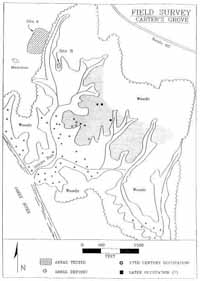 FIGURE 4
Field Survey Map of Carter's Grove Greene Tract.
10
shovel testing in the area surrounding the pit and brick concentration. The limits and function
of the site have not been determined.
Site G was also found during the 1978 survey, and artifacts recovered from this site
date it to the seventeenth century. No large-scale excavation of this site was conducted.
More recently, archaeological investigations were conducted on the parcel of Carter's
Grove property known as the Locust-Grove Tract (Moodey 1992). From February, 1991
through August, 1991, the Colonial Williamsburg Foundation Department of Archaeological
Research conducted Phase I and II surveys of eighteen sites on this tract, including the
above-mentioned sites F and G. From these surveys and testing, ten sites were identified
as having potential for further research. Site 44JC633 (CG-3) was one of those ten. Other
sites include four seventeenth-century domestic sites (CG-8, CG-2, CG-10, CG-11),
two multicomponent sites (F and G), two aboriginal sites from the Woodland Period (CG9,
CG-19), and the nineteenth-century burial ground (Matilda Jones Cemetery).3
11
An Overview of Virginia Prehistory
More than 20,000 prehistoric archaeological sites have been identified in Virginia.
These sites represent 10,000 years of Virginia prehistory (Wittkofski,
1990). In James City County 510 prehistoric sites have been inventoried. More
sites have yet to be discovered and more than is known have been destroyed through
time.
Prehistoric time in Virginia is viewed as that non-spatial continuum in which Native
American cultural periods occurred prior to contact with European cultures. Systematic
archaeological exploration of prehistoric sites have yielded a vast array of material culture.
These artifacts have been used extensively to establish chronologies of Native American
habitation. In general, the chronology of Virginia prehistory is as follows:
| Paleo-Indian Period | 12,000 B.C. -8,000 B.C. |
| Archaic Period | 8,000 B.C. -1,600 B.C. |
| Woodland Period | 1,600 B.C. -1,521 A.D. |
Time periods and subperiods are frequently argued based on new archaeological evidence
coupled with discoveries by means of absolute and relative dating (Griffin 1952;
Custer 1983; Johnson 1986; Gardner 1988; Hranicky and Painter 1989, among others).
In consideration of all time variables accepted and disputed, the following is a breakdown into subperiods:
| PALEO-INDIAN: | Early Clovis Phase | 12,000 -9,000 B.C. |
| Middle-Mid-Paleo Phase | 9,000 -8,500 B.C. |
| Late-Dalton Phase | 8,500 -8,000 B.C. |
| ARCHAIC: | Early Archaic | 8,000 -6,800 B.C. |
| Middle Archaic | 6,800 -4,000 B.C. |
| Late Archaic | 4,000 -1,600 B.C. |
| WOODLAND: | Early Woodland | 1,600 B.C. -300 B.C. |
| Middle Woodland | 300 B.C. -800 A.D. |
| Late Woodland | 800 A.D. -1521 A.D. |
These subdivisions of prehistoric time are focused primarily on the Tidewater ecozone.
Therefore, variations in time (particularly from Late Archaic through Late Woodland and
into the proto-historic period) will occur as regional archaeological examinations move
from Tidewater through the Piedmont and into the Mountain provinces and beyond.
Paleo-Indian Period
Paleo-Indian populations were organized into bands of about 200 individuals. These people
were highly mobile hunters and gatherers who depended on deer, elk and moose, as well
as small mammals and fish for subsistence (Custer 1990). The flexibility of these bands
12
allowed for adaptation to seasonal fluctuations as well as environmental changes over
longer periods of time (Moodey 1992).
The Paleo-Indian toolkit consisted mainly of implements made from microcrystalline
or cryptocrystalline silicate lithic materials, particularly chert and jasper (Gardner 1989;
Reinhart 1989). Materials of this type are conducive to the high quality of workmanship
characteristic of points and tools from this period (Gardner 1986). Consequently, cherts,
jaspers, and related lithic materials were highly prized and became the focus of extensive
procurement excursions. It is also assumed that this material became an important item of
trade (Reinhart 1989). The lithic technology that produced the noted fluted projectile
points and associated debitage is the basis for establishing the Paleo division of prehistoric
time (Johnson 1989).
The paleoenvironment of the Middle Atlantic region consisted of complex boreal forests
(Custer 1990). Some have argued, however, that this region was a complex mixture
of grasslands and boreal and deciduous woodlands (Boyd 1989; Gardner 1989).4
Settlement patterns of Paleo-Indians have been somewhat difficult to establish because
of the rarity of sites. A single, fluted projectile point usually constitutes a site. Approximately
50-75 Paleo-Indian sites have been identified in Virginia, with perhaps ten
located in the Piedmont and Coastal Plain provinces (Turner 1989). Gardner (1981),
proposed a model of settlement patterning comprised of five functionally distinct site types:
1) quarries; 2) quarry reduction stations; 3) quarry-related based camps; 4) base camp
maintenance stations; and 5) outlying hunting sites (Turner 1989).
Archaic Period
Indians of the Archaic Period were also mobile hunters and gatherers with seasonal treks
to specific areas for certain foods and lithic material. It is often debated that the earliest
part of Archaic time was actually a continuation of the Late Paleo-Indian Period (Gardner
1989). Although a certain amount of Paleo-Indian culture probably extended into the
Archaic Period, there were also important episodes of culture change (Custer 1990).5
Likewise, environmental change occurred during this time but it is unlikely that the transition
was as dramatic as once believed. Because of a poorly developed data base, however,
the Archaic Period of Virginia's prehistory is the time range where the least is known
(Custer 1989).
The term Archaic was first used by William Ritchie in describing cultural periods of
prehistory in the State of New York (Ritchie 1932; Gardner 1986). In Virginia, Archaic
denotes both a time frame and a stage in cultural development. As previously stated, the
Archaic Period was a time of mobile hunters and gatherers. Therefore, most characterizations
13
of Archaic time rely on a cultural perspective void of settled villages, agriculture, and
ceramic technology.
Floral remains both in the archaeological and geological records have contributed
extensively to the interpretation of Archaic environments and available animal species (Graham
and Mead 1987; Custer 1990; Brush, Lenk, and Smith 1980; Watts 1979; Davis
1983; Gadreau and Webb 1985). Custer (1990), suggests that animal species of the
Archaic parallel those of today; however, a variance of species density and distribution
occurred in time and space.
The rate of environmental change is very slow and spans generations of human existence.
Given the fact that residual changes in conditions included a more temperate climate
with increased moisture, a greater variance in seasons, and a rise in sea level (Belknap and
Kraft 1977), Early and Middle Archaic environments paralleled that of the Paleo-Indian
Period (Custer 1990). The environmental transition, then, as it affected prehistoric lifeways
and adaptations was more a cumulative effect with the resulting cultural change more
distinct in later Archaic time (Gardner 1986).
Very little information is available on settlement patterns and site adaptations of the
Archaic Period, especially in the Tidewater region of Virginia's Coastal Plain. Most archaeological
data derives from surveys and excavations conducted in the western part of
Virginia, specifically those in the Flint Run Complex in the Shenandoah Valley (Carr 1986;
Gardner 1989; Custer 1990).
The settlement strategies for sites above the Fall Line Zone are commonly linked to
raw lithic material resources and their procurement (Gardner 1989; Custer 1990). In
contrast, studies of Archaic sites below the Fall Line Zone focus on their proximity to
swamps, bogs, freshwater springs and other wetland areas (Custer 1982; Wanser 1982;
Rappleye and Gardner 1979; Custer and Bachman 1986).
Gardner (1977) proposed models for five Archaic site types which have been developed
into two models of settlement systems (Custer, Cavallo, and Stewart 1983). These
are:
- 1. Quarry Sites-An area for the initial procurement of lithic materials.
- 2.Quarry Reduction Sites-An area where bifacial preforms, flakes, and cores were
readied for transport.
- 3. Base Camps-Primary habitation site.
- 4. Base Camp Maintenance Stations-Resource procurement sites within close proximity
to the base camp. These areas are revisited by inhabitants of the base camp.
- 5. Outlying Hunting Sites-Resource procurement sites farther away from the base
camp.
In the two settlement models, Archaic groups are placed in either a cyclical pattern of
movement based on lithic resources and seasonality or in a serial model where movement
does not depend on raw lithic material resources (Figures 5 and 6).
14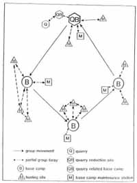 FIGURE 5
Cyclical Settlement Model.6
15  FIGURE 6
Serial Settlement Model.7
Woodland Period
The Woodland Period is always associated with the development of pottery and the practice
of horticulture. Villages were also constructed. A greater movement of other cultural
groups into Virginia occurred during this time. Specifically, contact took place between the
Mississippian, Adena and Hopewell cultures. Once contact was made with the Europeans,
metal tools and other European trade goods entered the Native American culture.
Stone tools of this period took on new characteristics with the triangle type being the
most prominent. Arrows made their appearance about five hundred years prior to European
contact. Compared with other time periods, Custer (1989) suggests "more varied
projectile point forms" derive from the Woodland Period. Numerous projectile point
typologies have been developed for Woodland Period tools but not, however, without
argument.8
16
With the advent of horticulture, lifestyles of the Woodland peoples became more sedentary.
Social systems grew in complexity as populations increased and cultural exchange
developed. Custer (1989) also characterizes the Woodland Period as a time that saw
"less portable storage technologies and non-transportable facilities ... stratified societies,
elaborate exchange systems, and complex burial patterns."
17
Research Design
Lithic Scatter Research: An Overview9
Until recently, archaeologists have avoided exploration of small, prehistoric sites on
the Coastal Plain of Virginia. Sites of this type are generally categorized as "lithic
scatters" and deemed insignificant. Neglecting to conduct archaeological excavations
and analysis of such sites has, over a period of time, created a gap in the archaeological
record. Site 44JC633 is significant in that the information derived will help to bridge
that gap in Virginia prehistoric archaeology.
Lithic scatters are quite abundant and have been considered the most common type of
"site" that relates to human habitation in prehistoric time. Blanton et al. (1991) describes
lithic scatters as being a low density of prehistoric artifacts, dispersed over an area and
consisting mostly, if not all, of lithic material. Caldwell (1954) and Coe (1964) noted that
these sites exist and provided a general description as being Archaic and derived from
short-term occupancy. Otherwise, they indicate these sites are of little importance and use
in the interpretation of the prehistoric record. This was to change, however, with the advent
of mandated cultural resource management (CRM) studies. Canouts and Goodyear
(1985) thoroughly document this trend and go on to describe how resultant documentation
of such sites by the hundreds compelled archaeologists to consider them more carefully.
This was particularly true in the Piedmont region and ultimately models accounting for
these sites were developed (House and Ballenger 1976, Goodyear, House, and Ackerly
1979) and even site-specific studies were conducted (House and Wogaman 1978;
Goodyear, House and Ackerly 1979:77-88).
Particularly exemplary of earlier areal studies involving these sites are the highway
corridor surveys in South Carolina conducted by House and Ballenger (1976) and
Goodyear, House and Ackerly (1979). In large measure these studies developed and
explored tenets of a riverine-interriverine settlement model. In this context the numerous,
small interior sites were expected to represent short-term procurement camps, either for
the extraction of nuts or white-tailed deer; larger sites adjacent to larger streams were
recognized as likely habitation/base camp sites. Criteria such as artifact density, assemblage
diversity, site size/complexity were utilized in evaluating the function of individual
sites. Ultimately, however, site-specific investigations were called for to better address
such issues.
Still prominent among the few site-specific studies of lithic scatters were the investigations
of the Windy Ridge (House and Wogaman 1978) and Stoddard (Goodyear, House,
and Ackerly 1979) sites which grew out of those survey projects. At the Windy Ridge Site
(38FA118) a block excavation was opened to evaluate the potential for preserved activity
18
areas. Contrasting distributions of raw materials were documented and spatial congruence
between Morrow Mountain hafted bifaces and quartz debitage was observed. These
results established that such sites can retain some internal structure, but in not all cases will
the ;significance of the patterns be readily apparent. Based on assemblage composition
and setting, the site was interpreted as the locus of repeated hunting camps for the taking
of white-tailed deer.
At the Stoddard Site (38LU42-Locus 3), a stratified unaligned surface sample was
obtained. While the overall sample was small, the results of the project were nonetheless
promising. What they indicated is that within an area defined as a single site, the distribution
of artifacts, including diagnostic items, was not uniform or random. Instead, Middle
and Late Archaic material was centered in different areas of the site. As a result it is
apparent that even cultivated and eroded upland sites can retain at least vestiges of their
structure and cannot be dismissed as having no information potential.
Both Windy Ridge and Stoddard were reoccupied locations comprised of multiple
loci, and in the case of Windy Ridge only one of these loci was excavated. Such has been
the norm in small site studies to date, in the sense that the richest, most obvious "lithic
scatters" are chosen for investigation beyond the survey level. A hidden limitation, however,
is that the complexity of sites created by multiple occupations acts to obscure patterns
and require tentative interpretations. Lacking have been investigations of the smallest,
lower density sites or loci representing a single occupation, which potentially stand to
yield the most useful, uncluttered information.
Archaeological Character of Lithic Scatters
Despite the progress that has been made over the past two decades in understanding the
role of these sites, it is still appropriate, albeit cliche, to declare that there is still much to
know. Before addressing the topics which merit focused attention, it will be helpful to
summarize the current state of knowledge regarding "lithic scatters."
If nothing else it has been sufficiently documented that sites of this type are, indeed,
very common and seemingly ubiquitous regardless of physiographic region. Attention was
first drawn to them via investigations in the Piedmont but studies in both the Coastal Plain
and mountainous regions have identified many such sites as well. Also, while within these
regions lithic scatters are proportionally more common in the interriverine areas relative to
large, "habitation" or "base camp" sites, it has become abundantly clear that they frequently
occur in the vicinity of major drainages. In effect, we can assert unequivocally that
these sites are the most common manifestation of prehistoric activity.
Through review of the literature it is clear that "lithic scatters" are not everywhere alike
and cannot be pigeon-holed, and subsequently dealt with, in a monolithic fashion. For the
purposes of discussion these sites can be characterized under two general headings. The
first includes lithic scatters which exist in the most literal or classic sense. Such sites are not
extensive but occur as relatively isolated, discrete loci of moderate to low artifact density.
These characteristics imply that occupation occurred only once or at least a minimal number
times, more or less precisely in the same location. In their purest form they would
19
represent a single occupation/component. Certainly though in this category the sites will
vary with respect to artifact density, size, setting, and number of components.
Another type of site often characterized as a lithic scatter is more extensive. Such sites
can cover relatively large areas but still consist of only low to moderate density scatters of
primarily lithic artifacts. An essential characteristic of this group is that they actually represent
accretional deposits composed of overlapping and/or contiguous, smaller loci of the
type just described. At first glance they give the impression of more permanence or larger
group size, when in most cases they are more the result of frequent reoccupation, often for
millennia. This kind of site is most common in places which seem to have had "favored
location" status, examples of which include locations near major streams, springs, or raw
material sources. CG-3 fits well into this scenario. It should be added, however, and it is
often difficult to discern, that some such sites may, indeed, be "aggregation" sites at which
the various loci represent activity/occupation areas of distinct social units which occupied
the site at the same time.
An issue that has arisen in the context of lithic scatter studies is assemblage composition,
namely whether it is variable from one of these small sites to another, perhaps in
different settings or time periods. Focused studies of this issue are not common but one,
again the Carolina Piedmont, can be cited as representative of the conventional wisdom.
Sassaman (1983) found that Middle and Late Archaic assemblages at South Carolina
lithic scatters were essentially redundant. In other words, the range of artifacts represented
at these sites showed no significant differences regardless of setting as measured by
distance to water, elevation, or landform. This is not to say that the site locations are
completely random, but rather that choice of settings is widespread and redundant, especially
where the topography and environment is homogenous in character.
Intra-site structure has been documented at some small sites, but primarily this has
been restricted to the discovery of "structure" in the form of overlapping or contiguous loci
at more extensive sites. This was the case at Site 44PW308 where one locus of an extensive
ridgeline site was isolated (Blanton and Robinson 1990). The significant, early investigation
at Windy Ridge also achieved similar results (House and Wogaman 1978). Controlled
surface collections have also yielded information supportive of the accretional structure
of some sites (Goodyear, House, and Ackerly 1979:77-88). The net effect of these
studies is that the presence of gross structure has been confirmed at multicomponent,
reoccupied sites, and that relatively discrete loci are present.
Finally, the prevailing opinion is that most of these sites are Archaic in origin. While this
has often been borne out by extensive surveys it is also clear that later, Woodland scatters
also exist. These are more prevalent prior to the Late Woodland in most areas, but are
known for all periods. These later small sites have received even less attention than their
Archaic counterparts and little about them is reported other than intersite, distributional
data.
Ethnoarchaeological Contributions to Lithic Scatter Studies
Much of the inspiration for the study of lithic scatter sites in recent decades derives from
results of ethnoarchaeological research among modem hunter-gatherers such as the Australian
20
Aborigines, Kalahari Bushmen, and Inuit Eskimo. By observing these groups researchers
have recorded the formation and/or use of small, ephemeral sites and regularly
compared them to archaeological lithic scatter sites. The dynamics of these behaviors and
processes have been examined and described for an archaeological audience with the
goal of improving prehistoric hunter-gatherer studies.
These contributions will be reviewed in the remaining portion of this section. Before
beginning, however, some qualifying comments are in order. It has been observed more
than once that ethnoarchaeological studies all too often generate "cautionary tales" stressing
the limitations of archaeological methods and data. These concerns generally are linked
to the complex interrelationships between material culture and behavior. At the same time
positive results have emerged, but often as only general or simple linkages between behavior
and material culture. Another shortcoming is the fact that recently extant hunter-
gatherer groups were restricted largely to marginal or extreme environments. Consequently
it has been cautioned that argument by analogy with regard to prehistoric contexts must be
limited and that both cultural and environmental contexts be seriously considered. In spite
of these limitations the results have ultimately proven useful and continue to enhance archaeological
interpretations of small sites; it will be in this vein that the results of these
studies are applied here.
Among the earlier studies of this nature is that by Yellen (1977) with the ¡Kung in
southern Africa. To describe intra-camp patterning he developed a model which segregates
a camp into two concentric rings. The Inner Ring is described as the focus of virtually
all communal activities, and includes shelters, hearths, and their related scatters of debris.
A direct correlation is proposed between the area of the inner ring and group size. The
Outer Ring lies immediately beyond the inner ring and encompasses the space devoted to
more specialized and ephemeral activities such as butchering and hide dressing. A like
correlation is proposed between the extent of the outer ring and duration of occupation.
Within each of the rings can occur smaller, fairly discrete "limited areas of scatter," and
these can be subdivided into either "nuclear area scatters" which are linked to family unit
activities near a hearth/hut, versus "special activity areas" elsewhere. The former are "richer"
or exhibit greater diversity of materials than the latter, owing to their repeated use and
status as a focal point of many daily activities.
Other of Yellen's more specific observations are important to consider. Of primary
importance is the fact that the smallest camps tend to be less regular in their arrangement
and often conform to natural features such as vegetation. Sites in this category are the most
temporary and ephemeral and should have their correlates in the archaeological record.
His observation that the hearth areas are the focus of repeated and diverse activities is
significant. Among these are manufacturing as well as cooking and socializing. As a result
by-products of both subsistence and manufacturing activities are regularly intermixed. Hut
areas are not marked by debris scatters since they serve almost exclusively for sleeping.
While specialized activities take place beyond the inner circle and their location is not
random, their occurrence is often dependent on less concrete factors such as where shade
can be found.
21
Archaeological applications of this model are dependent on a few factors. One is that
naturally constrained areas such as rock shelters do no permit such an arrangement of
activities. A second is that all or virtually all of a site must be excavated or assessed in
order to observe such configurations. Finally, at sites (groups) surpassing a certain size the
pattern may break down as alternative arrangements are adopted. Otherwise application
of the model may have some utility, namely for the interpretation of site structure. It remains
to be established, however, in a variety of settings and environments, whether such
patterning is present or observable. In this respect, intensive studies should make this a
priority issue. Eventually regionally and temporally distinct patterns may emerge with respect
to infra-site structure, even to the point that such patterns will be as diagnostic as
formal artifacts can be. Also potentially discernible with sufficient samples will be group
size, duration of occupation, and site function.
Both Gould (1980) and Binford (1983) have conducted ethnoarchaeological research
among Australian Aborigine groups in desert regions of western and central Australia.
Gould has elucidated important patterns related to the procurement and use of lithic materials,
but these relate more to inter-site differences as opposed to infra-site patterning and
are pertinent to all sites (Gould 1978, 1980; Gould and Saggers 1985). More relevant to
this discussion, he does recognize two basic categories of sites and contrasts their structure
and assemblage composition (Gould 1980).
Habitation-base camps are those sites which are occupied by the largest group sizes
comprised of all ages and sexes. They occur in locations continuously reoccupied due to
their proximity to water and other significant resources. Such sites are more extensive and
the array of activities, and consequently discards, is very diverse. Internally they are often
comprised of distinct occupation and activity areas but he is quick to note that these
become quickly obscured by the effects of intensive and repeated use. Only the largest
features and the latest activities are potentially discernible in the general scatter. Specialized
activity sites on the other hand are much smaller and retain more integrity. They serve
as the loci of specific resource extraction such as quarries, as hunting blinds, or as overnight
camps. Most often they are occupied by only one age and sex group and for seldom
longer ,than one overnight. Consequently the residues which remain tend to stay where
they were originally left and retain high potential for ethnoarchaeological or archaeological
interpretation.
In practice, this simple dichotomy of settlement types is a mainstay of current hunter-
gatherer settlement studies. What is lacking, however, are better models of intra-site organization.
Clearly the smallest, most ephemeral sites stand to yield more readily definable
patterns. At the larger, reoccupied sites the potential for confident interpretation is linked
directly to the intensity of reuse. In less constrained, temperate environments the degree of
reoccupation may be relatively less intensive and, thus, more conducive to pattern analysis.
A potential avenue for study, based on the assumption that the equivalent of these
smaller sites are the basic building blocks or components of larger camps or reoccupied
sites, is to focus on the structure of small, well-preserved scatters in order to elucidate or
infer the basic structure of larger, more complex sites of the same period.
22
Lewis Binford has based much of his model-building on the results of ethnoarchaeological
observations. While he, too, has focused more often on inter-site, settlement issues, some
of his infra-site studies are important to this discussion. To begin, Binford (1983:139-149)
refines the understanding of internal site organization beyond Yellen by reporting other
distinctive but culturally-dictated arrangements. He notes that in contrast to the ring pattern,
semicircular, linear, and dispersed arrangements of huts or minimal group spaces are
reported within individual camps. It is further noted that in the most dispersed camps, the
individual scatters may wrongly be defined as separate, non-contemporary sites in an
archaeological context.
At a more refined level, Binford also acknowledges that hearths are the focus of an
array of activities. Working with Eskimo hunters, he observed two general but distinctive
areas of discard around a hearth. Closest to the hearth in the seating area is what he terms
a "drop zone." It is here that the smallest, usually incidental by-products of activities fall
and are left. Just beyond the drop zone, further from the hearth, is a "toss zone." Larger
pieces of debris are intentionally removed or literally tossed into this perimeter as a form of
hearth area maintenance. Interspersed in these zones, but more often beyond the drop
zone, can be small "dumps" where homogenous collections of debris from specific activities
are discarded. Examples would include debitage from stone working, bone scraps
from butchering, or even broth from cooking. Once established, such areas can become a
"magnet" for subsequent dumpings, eventually creating a larger, mixed disposal area.
The extent and complexity of these patterns are clearly contingent on group size and
the length of occupation. Other complicating factors include the bulk of discards and
weather. Activities resulting in large quantities of debris will be carried out farther from the
central activity area. These decisions are also based on the length of the occupation,
relating to whether the debris will eventually interfere with other activities later. In the same
way that Yellen makes note of shade as a factor contributing to selection of activity areas,
Binford observes that wind can effect the ultimate configuration of a site. Shifting winds
can cause hearths and activity areas to be moved for continued comfort.
Binford concludes that many hunting and gathering groups organize their space similarly
within sites, most often in a circular or semi-circular pattern around hearth areas.
Other patterns are recorded but occur less universally. The regularities he documents are
encouraging for archaeological evaluations of small lithic scatters. While the pitfalls of
direct analogy must be consciously avoided, his models are useful starting points for interpretation.
Proposed Research Approaches for the Treatment of Lithic
Scatters
At this point the potential for future lithic scatter studies can be outlined. Progress has been
made but it will be argued that their research potential is far from exhausted and serious
consideration, combined with creative approaches to study, can yield significant results.
These suggestions will not include a discussion of such sites from the standpoint of settlement
studies. This does not imply that this area warrants no further inquiry, but simply that
23
this topic has been more typical of lithic scatter treatments to date and that more pressing
is the need to assess the sites individually. In so doing a more accurate appraisal of the
function, duration of occupation, and variability of scatters can be attained.
Having documented that intra-site structure exists at least on a gross scale in the form
of loci, a crucial next step is to investigate structure within individual loci. The principle
goals of this would be to examine the organization of activities and patterns of discard
within locus boundaries. Based on distributions of artifacts, including refitting/conjoining
results, it may be possible to infer where activities did and did not take place and in turn
estimate group size and duration of occupation. Features in the traditional sense should not
necessarily be expected but areas of relative artifact concentration can be treated similarly.
The resulting distributional information can potentially be interpreted in terms Binford's
(1983) toss and drop zone, and other ethnoarchaeologically-derived models.
Not all lithic scatters will be conducive to focused study.Archaeologically the sites of
this type most likely to yield significant information are 1) those that retain sufficient integrity
as indicated by spatial patterning, and 2) those that represent single or a minimal
number of occupations. In the first instance, well preserved examples are rarely located.
The ephemeral nature of many such sites makes them the most subject to damage from
any number of sources. Severe impacts commonly result from plowing/land clearing/logging
and subsequent erosion. This is, a problem particularly in the Piedmont where shallow
soils and considerable relief result in many deflated and mixed deposits. Similar conditions
also occur in sections of other physiographic provinces, including the Coastal Plain. An
unfortunate reality is that many locations where better-preserved scatters can be expected
are in marginal settings, which are not necessarily representative of an area at large. For
instance site locations often coincide with the areas of extensive arable soils. Since these
areas have the longest history of clearing and cultivation, however, they cannot be expected
to contain well preserved sites. Instead, sites with integrity are more apt to occur
where favored, arable soils are limited in extent, such as in poorly drained sections of the
Coastal Plain or on restricted landforms in the Piedmont.
Pattern analysis will be most productive at sites representing single or very few episodes
of occupation. Otherwise, the clutter of overlapping occupations is almost impossible
to dissect and interpret. Again, reoccupied sites are common and are not random
occurrences. Certain localities were favored for various reasons which we should attempt
to identify. A goal should be to seek sites of this type with minimal reoccupations, or where
the component loci are spaced horizontally such that overlap between them is minimized.
In these cases there remains potential for fruitful analysis.
Ultimately, an appreciation for the nature of lithic scatters will depend on a carefully
selected sample of sites investigated in similar fashion. It is safe to say that sites of this
nature are routinely "written off' as insignificant or as having no research potential beyond
a record of their location for the purposes of settlement analysis. Through this and other
studies it is hoped that this view can be challenged and the potential of well preserved lithic
scatter sites demonstrated. A key element in this program will be to examine several sites
to allow for comparisons.
24
Minimally the sample should be comprised of at least one site from a representative
range of settings within each of the major physiographic provinces. For instance, in the
various provinces lithic scatters from major floodplains, along interior drainages, and in
upland settings should be excavated. Perhaps these categories could be further refined to
include examples representing different time periods. In addition, while it is true that the
best preserved examples should be given priority, it would be instructive to also investigate
others which have been plowed or otherwise disturbed to assess the negative effects or
limitations they have.
Sites of this class with the potential to yield significant information can only do so with
intensive investigation. Standard survey or testing methods consisting of interval testing
using shovel tests and/or test units, or grab samples in surface contexts, will serve only to
identify these sites. In the case of some of the smallest examples, only one or two positive
tests may mark their existence. Therefore it is imperative to open a series of contiguous
units, or conduct controlled surface collections, within the site area to discern patterns and
accurately define boundaries. Only under an intensive excavation regime can subtle but
meaningful variations in artifact density and distribution be recorded. Certainly analyses
involving refitting and density plots will benefit from or be impossible without this approach.
Recovered data should be subjected to careful spatial analysis. Both the limited archaeological
results available and ethnoarchaeological studies indicate that internal structure,
manifest as variations in artifact density and distributions, should be present at these
sites. With the benefit of intensive sampling results, recovered material can be plotted
along a multitude of dimensions in the first step of pattern analysis. Different gross classes
of material can first be plotted for clues to the location of activity or discard areas. When
such areas are indicated, more specific categories of material can be plotted to evaluate
the composition and, thus, the origin and significance of a concentration. It will be from
these results that such questions as group size, duration of occupation, and site function
can be addressed.
Spatial analyses can be enhanced by refitting or conjoining studies. Some of the most
irrefutable support for pattern analysis can be derived from the refitting or conjoining of
artifacts. The number and relationship of refits can act as a strong measure of the complexity
of a deposit or assemblage. Under the most ideal circumstances it will be possible to
estimate such things as the minimum number of bifaces, cores or other tools represented.
This information can be applied in inferring group size and duration of occupation. Likewise,
the interrelationships of crossmends and will make interpretations of activity areas
and the number of occupations/components more realistic. For an example of the application
of this method, articles by Cahen, Keeley, and Van Noten (1979) and Cahen and
Keeley (1980) should be consulted.
The contribution of well-designed lithics analysis in this endeavor can be significant,
owing in large measure to the fact that lithic artifacts comprise all or the better part of most
assemblages. From this perspective it actually is imperative to maximize the interpretive
potential of lithic material, but at the same time to integrate its study with that of other
classes of information. Guiding this work are a set of basic research questions that concern
25
problems of intra-site organization and function, as well as inter-site or regional settlement
dynamics.
Based on the results of both archaeological and ethnoarchaeological studies certain
current understandings and expectations about lithic assemblages from small sites can be
outlined. At the most general level these are that:
- 1. Late stage reduction and maintenance will be indicated; key indicators are rare
cortical debitage and an abundance of thinning and retouch flakes.
- 2. A limited array of tools will be present due to the specialized nature of the sites.
- 3. Artifact densities will be relatively low due to the short occupation span and small
group size.
- 4. The ratio of debitage:tools will be low since tool production was not common.
Cores and early stage bifaces will also be rare for the same reason.
- 5. A large proportion of the tools recovered will be either expedient or broken since
still-functional items will be curated and removed for use at other locations.
Some component-specific expectations are that:
- 1.The degree of variability between assemblages at different sites of the same period
may change through time and indicate different settlement/subsistence strategies.
In other words, in periods marked by logistical subsistence strategies (such
as Paleo-Indian) or semi-sedentary settlement (such as Late Woodland) the assemblages
at different sites are potentially more variable (i.e., between base camps,
seasonal camps, and procurement sites). Inter-site/assemblage distinctions are
minimized in foraging systems (such as in the Middle Archaic).
- 2. A corollary of the preceding statement is that as subsistence/settlement strategies
vary through time, so does technological organization in general. In basic terms,
curated/standardized/formalized technologies and toolkits are more characteristic
of logistically organized systems. Expedient/generalized technologies are more often
associated with foraging systems. These examples are restricted in large measure
to hunter-gatherer adaptations, however. Extending the argument to more sedentary
systems, research has indicated that in general lithic technology is very unstructured
and expedient, although some specialized but limited production of
status/exchange items can occur.
To test and further refine these expected patterns, a series of basic objectives and
approaches is outlined below. These are designed to be applicable to a variety of sites in
a variety of settings.
Among the more basic issues is patterns of lithic raw material procurement and use. In
other words, what materials were utilized, what can their distributions tell us, how did this
change through time, and how is the factor of availability manifested? Baseline information
about the "lithic landscape" of the area must be compiled at the outset. This will involve
consultation with area geologists, -field checks of sources, and a literature review. As the
analysis proceeds, the raw material represented will be recorded for all classes of material.
26
This will reveal what the favored raw materials were. It can also evidence the "mobility
scale" and/or patterns of inter-group contact. With these complementary sets of information
the questions posed about procurement and use patterns can be addressed.
Another fundamental issue concerns the temporal dimension or cultural history. It is
important to determine the period(s) of site use vis-a-vis current taxonomies and sequences,
but also to refine the regional temporal sequence if possible. All formal artifacts will be
typed according to current descriptions and metric attributes will be recorded.
A related but less common feature of chronological studies is identification of temporal
signatures among other classes of artifacts such as debitage. In short, it may be possible to
identify attributes of reduction strategies that are no less temporally sensitive than so-
called "diagnostic" items. For instance, the frequency of bipolar, structured biface, expedient,
and other reduction strategies can vary through time and be positively linked to
certain periods.
Where patterns of reduction are observed that do not have temporal significance, they
should be evaluated for functional significance instead. The same patterns of reduction
cited above are also linked as well to different patterns of adaptation and settlement. For
instance, the degree of mobility and/or the type of subsistence organization can be manifest
by specific reduction strategies.
Lithic artifacts should be considered in studies of site structure. Distributions of different
classes of lithic artifacts within a site can be important indicators of activity and discard
areas and, perhaps, group size or composition. Such should include a refitting study to
gauge the contemporaneity and integration of activity areas. Both vertical and horizontal
distributions can provide clues to formation processes as well.
Every effort should be made to characterize the technology represented. This can
entail evaluation of core and biface reduction strategies, what stages are represented, how
they vary through time, and what their implications are for inferring site function. Of special
interest is how the lithic reduction-maintenance continuum is manifest at these small, interior
sites. Did production or early stage reduction occur elsewhere or did this change
through time? Are these patterns consistent from site to site and among different raw
materials? The patterns identified should provide indirect measures of duration of occupation
and patterns of movement.
The functions of the artifacts recovered and what they reveal about site function is an
important consideration. Without use-wear studies the function of different tools must be
inferred from tool form. This usually provides only general information. However, and time
permitting, breakage patterns, gross edge morphology, and macroscopic damage can be
examined to refine the evaluations. A product of this analysis will be to produce ratios of
different tool types represented at different sites and components. These will provide
standard comparative indices from which site function can be assessed.
Ultimately a goal of the study will be to characterize the toolkits represented at these
sites and, of course, what they reveal about site function, group mobility, and subsistence
activities. Here again, ratios of different tool types represented at different sites will be the
basis for this assessment. An important feature of this and other aspects of the analysis will
27
be to compare the 44JC633 findings with those from other areas and sites, but especially
larger estuarine/riverine sites that presumably represent macro-social aggregation or base
camp locations.
28
33
Research Results
Introduction
The basis for the evaluation process of- Site 44JC633 derives from the research
goals and field methods previously described. Extensive laboratory analysis was
made possible from the systematic and comprehensive excavation and recovery
of lithic artifacts from the site.
Results of Fieldwork
Site Structure
Preliminary test units and arbitrary shovel test profiles were consistent with previous Phase
I and II testing. Two separate and distinct concentrations of lithic debris, spaced eleven
meters apart, were located within the boundaries established during the Phase II survey.
These two concentrations were recorded as Locus-1 and Locus-2. The northernmost
part of Locus-1 is situated between 272N/258E and 272N/264E and the easternmost
part between 272N/258E and 272N/260E (28 square meters). Eighteen 1 x 1 m units of
Locus-1 were excavated. The northernmost part of Locus-2 is located between 273N/
276E and 273N/280E. The easternmost section is between 273N/276E and 273N/273E
(30 square meters). Nineteen 1 x 1 m units of Locus-2 were excavated. A test trench 11 m
x 50 cm was put in between these loci. At the conclusion of Loci 1 and 2 excavations, ten
50 x 50 cm test units were dug north, west, and south of Locus-1 (30 units total) and
north, east, and south of Locus-2 (30 units total). These shovel tests, at two meter intervals,
were a final test to ensure the extent of the site.
Two strata were initially identified underlying an organic plowzone of dark brown
sandy loam (10YR 5/3) that varied in thickness from 20-35 cm. These strata sealed an
orange sandy clay subsoil (7.5YR 5/8). The first layer identified as the Intermediate
Layer was a white loamy sand with clayey inclusions (10YR 8/2). This soil covered the
entire area within and beyond the parameters of the site in an east-west trend and extended
only three meters to the south. It appears that early settlement and subsequent land
use had obliterated this layer beyond the outer three meters. It is interesting to note that the
same soil layer appeared again on the southernmost side of the adjacent site 44JC647
(CG-8), a seventeenth century domestic house site. Tests indicate that this stratum also
continues northward to the existing Route 60.
The second stratum underlying the Intermediate Layer was identified as the Transitional
Layer. This layer was a white-orange sandy clay (7.5YR 7/6) and like the Intermediate
Layer covered the entire site. The Transition Layer mimicked the sterile subsoil,
often making it difficult to define.
The Intermediate Layer did not suffer the consequences of plowing. Soil profiles and
descriptions derived from test units and unit excavation on the site suggest that the site is
relatively intact. Floral turbation was minimal in the area, with the exception of several tree
34
features that existed on the western edge of Locus-1 (Figure 9). Rodent disturbances
existed, but they too were minimal and appeared to have missed all lithic features. The
distribution of artifacts in and around the tree area was probably somewhat skewed.
Closer examination of the soil layers revealed that extensive leaching had occurred in
the Transition Layer. Therefore, it is probably correct to assume that only one layer actually
exists between the plowzone and subsoil, with the lower portion affected by the leaching
processes. Based on this assumption, artifacts initially associated with two strata were
grouped together under one context per unit (for analytical purposes).15
Shovel Test Results
An experiment was conducted in the early stages of this excavation which involved testing
the artifactual content of the plowzone. It is theorized that plowzone data can possibly
predict underlying, undisturbed contexts (Hoffman 1982). Accordingly, fifty-three shovel
tests were randomly placed in concentric circles within the parameters of the site as defined
in Phase I and II testing (see Figure 8). Twenty-seven of the fifty-three shovel tests,
or 50.9% were positive, recovering the following lithics:
| Cortical | Non-Cortical |
|---|
| Primary Reduction Flake | 3 | 0 |
| Secondary Thinning Flake | 0 | 9 |
| Flake Fragments/Shatter | 7 | 14 |
| Bipolar Flake | 1 | 0 |
| Fire-Cracked Rock | 7 | 0 |
| Miscellaneous/Unmodified Stone | 31 | 0 |
Additionally, one complete Hafted Biface, Guilford type, was recovered.
These positive tests correlated well with the location of lithic features discovered during
Phase III excavations.16 The shovel tests also confirmed the extent of intact layer(s)
below the plowzone and the general boundaries of the site. Naturally the testing of one site
produces inconclusive evidence to support the basic hypothesis of plowzones and predictability.
It is suggested then, from these results, the predictive value of plowzone testing
has some merit; however, certain variables exist that could alter the results of plowzone
testing in other areas. For instance, slope, drainage, landform type, plowing history, etc.,
are variables that could impact positively or negatively on the outcome of testing other
sites in this manner. These results do, however, make a significant contribution to the
database of plowzone research in archaeology.
35
Test Unit Results
Eight one-by-one meter test units were initially opened based on data from Phase I and II
surveys (Figure 10). A total of 282 prehistoric artifacts were recovered from these units,
95.7% (n=270) of which consisted of lithic reduction debitage. Also included in the assemblage
were ten pieces of miscellaneous/unmodified stone, one fire-cracked rock, and
one complete informal groundstone (hammerstone). No ceramics or diagnostic lithics of
any kind were recovered from these units. Debitage consisted of the following:
| Cortical | Non-Cortical |
|---|
| Primary Reduction Flakes | 9 | 2 |
| Secondary Thinning Flakes | 3 | 43 |
| Flake Fragments/Shatter | 22 | 191 |
Primary reduction flakes accounted for 4.1% (n=11) of the debitage. Secondary thinning
flakes made up 17% (n=46) of the assemblage. The remaining debitage consisted of
flake fragments and shatter (78.9%, n=213). No tertiary flakes were recovered from the
processing of water screen samples collected from each arbitrary level of each test unit.
Cortical debitage makes up 12.6% (n=34) of the total debitage. Since the basic reduction
data suggests more secondary thinning flakes than primary reduction flakes, it is probably
correct to infer that initial reduction of the materials occurred elsewhere. It is, however,
clear that significant intermediate stage reduction was conducted in the area of the test
units. The debitage yielded no evidence of tool maintenance or final stage reduction.
The horizontal distribution of the debitage indicates a distinct concentration of lithic
debris with a lesser density around the periphery of the concentration. Existing variations
in debitage distribution between layers is quite small and can be considered the result of
root activity and other natural soil processes. Cahen et al. (1979), suggests vertical
dispersement of artifacts can occur from post-depositional biogenic perturbations.
Results of Artifact Analysis
Lithic materials recovered from 44JC633 were extensively examined in the laboratory. As
an initial step in sorting materials, a "lithic landscape" was recreated by arranging all stone
artifacts in a grid pattern - the same as was used for the excavation. As this arrangement
proceeded, it was obvious that a minimal number of original blocks of raw material were
present at the site, and that sorting of debitage into their original constituent blocks was
possible. Additionally, the possibility of refitting a number of these pieces became evident.
In Locus-1, six quartzite blocks and one quartz block were defined (see Table 1).
Eleven quartzite blocks and one quartz block were defined in Locus-2 (see Table 3).
These should be viewed as a minimum number of blocks. It should be noted that
because the examination and sorting of the debitage was strictly visual, some error and
misclassification may exist. Natural variation within the blocks, as well as the fact that
some had been altered by heat, made classifications at times difficult. Micro-debitage and
those pieces that could not be associated with any particular block were not considered in
the individual block analysis.
36
Data initially gathered on the individual blocks concerned quantities, weights, refitting
within blocks, and the presence of cortex on individual pieces of debitage. In consideration
of these factors over the horizontal scale of site distribution, the lithic materials were
examined to detect patterns of site functions and activities.
In any quantitative study, the size of the sample is always an important factor. Therefore,
all blocks in both loci were used as the focus of this study. Blocks of debitage in
Locus-1 and Locus-2 account for 23.8% (n=334) and 76.2% (n=1072) of the debitage
recovered from the site respectively.
 FIGURE 9
Tree Hole Features.
37
 FIGURE 10
Initial Test Units for CG-3.
38
Locus-1:
The relative frequencies of the six quartzite blocks and the one quartz block are represented
in excavation units on a line graph (Figure 11). In terms of relative highs and lows,
each block exhibits a close correlation in patterning. This close proximity of lithic block
distribution could suggest a single occupational episode.
The primary depositional focus at Locus-1 is quite clear in Figure 11. The prominent
peaks are those areas where lithic materials from most or all of the blocks were deposited.
Units 401, 402, 403, 600, 601, and 602 are contiguous units that correspond with the
most densely saturated areas in the overall distribution of debitage.
Regardless of the uniformity of structure and composition of the block debitage distribution
patterns and the few tree hole disturbances previously described, site structure
could still be detected. Figure 11 also illustrates some important patterns of distributional
variation. Blocks D and E have peaks at Unit 603. Block B, in addition to peaks noted in
other units, peaks again in Unit 604. Block A has slightly prominent peaks along the same
plane in Units 618 and 619. Unit 619 also shows distinct concentrations of Blocks B
and C. Figures 12, 13, 14, 15, 16, and 17 illustrate these differences as well as the patterns
of deposition for individual blocks.
The raw quantities of debitage in each unit are illustrated in Figures 12 and 13. The
high density areas for each block (except Block E), are generally near the south-southwest
corner of Locus-1, surrounded by an almost circular pattern of diminishing artifact
concentrations. No "dead zone" seems to exist, with the exception of Block E. Variance in
size and location of the high density focus is minimal. This variance, more specifically, is
characterized per block in Table 2.
Four general areas of focused deposition are described by these quantitative distributions.
These overlapping areas suggest that lithic reduction of Blocks A, B, C, D, and F
TABLE 1.
Block Classifications By Unit Locus-1
| Unit | A | B | C | D | E | F | G [Quartz] |
|---|
| 222 | 5 | 4 | 3 | 7 | 0 | 1 | 1 |
| 401 | 19 | 17 | 18 | 15 | 0 | 0 | 1 |
| 402 | 21 | 4 | 1 | 16 | 1 | 5 | 0 |
| 403 | 9 | 4 | 6 | 8 | 0 | 1 | 0 |
| 404 | 2 | 1 | 0 | 0 | 0 | 1 | 0 |
| 405 | 2 | 2 | 0 | 0 | 2 | 0 | 0 |
| 600 | 8 | 11 | 5 | 12 | 0 | 3 | 0 |
| 601 | 5 | 6 | 9 | 9 | 0 | 1 | 0 |
| 602 | 13 | 9 | 4 | 8 | 0 | 0 | 1 |
| 603 | 2 | 2 | 0 | 6 | 3 | 0 | 0 |
| 604 | 2 | 6 | 0 | 1 | 0 | 0 | 0 |
| 618 | 5 | 2 | 3 | 3 | 0 | 2 | 1 |
| 619 | 5 | 2 | 2 | 3 | 0 | 0 | 1 |
| 620 | 0 | 0 | 0 | 1 | 0 | 0 | 0 |
| 621 | 1 | 0 | 0 | 0 | 0 | 0 | 0 |
| Totals | 99 | 70 | 51 | 89 | 6 | 14 | 5 |
|---|
39
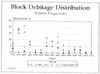 FIGURE 11
Block Debitage Distribution
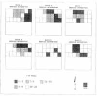 FIGURE 12
Distribution of Quartzite
Blocks A, B, C, D, E, and F by Quantity
(Locus-1).
40
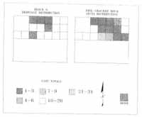 FIGURE 13
Distribution of Quartz Block G
and Fire-Cracked Rock (FCR) by Quantity
(Locus-1).
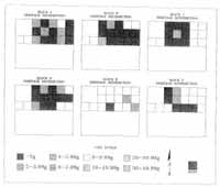 FIGURE 14
Distribution of Quartzite Blocks
A, B, C, D, E, and F by Mean Weight Per Flake
(Locus-1).
41
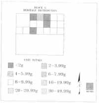 FIGURE 15
Distribution of Quartz Block G
by Mean Weight Per Flake
(Locus-1).
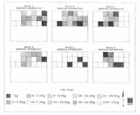 FIGURE 16
Distribution of Quartzite Blocks
A, B, C, D, E, and F by Weight
(Locus-1).
42
FIGURE 16
Distribution of Quartzite Blocks
A, B, C, D, E, and F by Weight
(Locus-1).
42
 FIGURE 17
Distribution of Quartz Block G by Weight
(Locus-1).
TABLE 2.
Areas of Depositional Focus for Individual Blocks
(Locus-1)
| SIZE OF FOCUS | | AREA OF FOCUS | | | | |
|---|
| BLOCK | SMALL | WIDE | SW | SC | CENTER | EC | NWC |
|---|
| A | | x | x | | | | |
| B | x | | x | | | | |
| C | x | | x | | | | |
| D | | x | x | | | | |
| E | | x | | | | x | |
| F | x | | | x | | | |
| Quartz | | x | | | | | x |
| SW = | Southwest central portion of the site |
| SC = | South central portion of the site |
| CENTER = | Central portion of the site |
| EC = | East central portion of the site |
| NWC = | Northwest central portion of the site |
43
occurred at four locations in or near the southwest corner of the site. The highest artifact_
concentrations occurred in the southwest area with a thinner scattering around the seating
area. Block E shows a small concentration in the east central portion of the site and Block
G (Quartz) debitage is concentrated in the northwest central portion.
Figure 13, the distribution of fire-cracked rock (FCR), corroborates the established
central focus of the site. Twenty-one to thirty-one pieces of FCR were concentrated in the
southwest corner of Locus-l, with a fanning out of FCR in lighter concentrations. It is
interesting to note that higher concentrations occur in the northeast corner as well.
Locus-2
Figure 19 illustrates the relative frequencies of 11 quartzite blocks and one quartz block.
Using the system of "peaks and valleys," all blocks of lithic material are patterned in close
correlates. As in Locus-1, this tightly knit distribution could represent a single episode of
occupation.
Again, as in Locus-1, the prominent peaks in Figure 18 indicate the primary depositional
focus. Units 771-781 are the most densely saturated areas in the overall distribution
of debitage at Locus-2. Within these units, Blocks A and B dominate the debitage. The
remaining blocks of lithic material are found in virtually all units. Units 417, 434, 616, and
801 contain little or no material from Blocks: A and B.
Figures 19, 20, 21, 22, 23, and 24 show these variations in addition to depositional
patterns for individual lithic blocks.
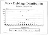 FIGURE 18
Block Debitage Distribution: Relative Frequencies
(Locus-2).
44
TABLE 3.
Block Classifications By Unit
(Locus-2)
| Unit | A | B | C | D | E | F | G | H | I | J | K | L |
|---|
| 417 | 2 | 3 | 0 | 0 | 0 | 0 | 0 | 0 | 0 | 0 | 0 | 1 |
| 434 | 2 | 1 | 0 | 0 | 0 | 0 | 0 | 0 | 0 | 0 | 0 | 0 |
| 616 | 0 | 0 | 0 | 0 | 0 | 0 | 0 | 0 | 0 | 0 | 1 | 0 |
| 770 | 0 | 1 | 0 | 0 | 0 | 0 | 0 | 0 | 0 | 0 | 0 | 0 |
| 771 | 36 | 13 | 3 | 2 | 3 | 0 | 1 | 1 | 2 | 4 | 3 | 3 |
| 772 | 51 | 13 | 4 | 4 | 1 | 1 | 1 | 1 | 0 | 0 | 1 | 2 |
| 773 | 27 | 13 | 3 | 1 | 0 | 0 | 0 | 0 | 4 | 2 | 3 | 0 |
| 774 | 124 | 20 | 3 | 2 | 2 | 2 | 1 | 1 | 1 | 1 | 1 | 1 |
| 775 | 84 | 19 | 7 | 2 | 0 | 3 | 2 | 3 | 4 | 4 | 3 | 0 |
| 776 | 20 | 9 | 1 | 0 | 4 | 0 | 1 | 0 | 1 | 2 | 0 | 0 |
| 777 | 119 | 50 | 5 | 1 | 5 | 0 | 2 | 0 | 3 | 5 | 1 | 2 |
| 778 | 131 | 47 | 1 | 0 | 3 | 0 | 0 | 9 | 1 | 2 | 0 | 0 |
| 779 | 10 | 2 | 0 | 0 | 0 | 0 | 0 | 0 | 0 | 2 | 0 | 1 |
| 780 | 21 | 5 | 1 | 1 | 4 | 0 | 1 | 1 | 1 | 2 | 1 | 0 |
| 781 | 24 | 12 | 1 | 0 | 0 | 3 | 3 | 2 | 2 | 1 | 0 | 0 |
| 782 | 8 | 3 | 3 | 0 | 1 | 0 | 1 | 0 | 0 | 0 | 0 | 0 |
| 790 | 6 | 3 | 0 | 0 | 0 | 1 | 0 | 1 | 1 | 5 | 1 | 1 |
| 791 | 2 | 1 | 0 | 0 | 0 | 0 | 0 | 0 | 1 | 0 | 0 | 0 |
| 801 | 0 | 0 | 0 | 1 | 0 | 1 | 0 | 1 | 0 | 0 | 0 | 0 |
| Totals | 667 | 215 | 32 | 14 | 23 | 11 | 13 | 20 | 21 | 30 | 15 | 11 |
|---|
 FIGURE 19
Distribution of Quartzite Blocks
A, B, C, D, E, F, G, H, I, J, and K by Quantity
(Locus-2).
45
 FIGURE 20
Distribution of Quartz Block L
and Fire-Cracked Rock (FCR) by Quantity
(Locus-2).
 FIGURE 21
Distribution of Quartzite Blocks
A, B, C, D, E, F, G, H, I, J, and K by
Mean Weight Per Flake
(Locus-2).
46
 FIGURE 22
Distribution of Quartz Block L
by Mean Weight Per Flake
(Locus-2).
 FIGURE 23
Distribution of Quartzite Blocks
A, B, C, D, E, F, G, H, I, J, and K by Weight
(Locus-2).
47
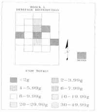 FIGURE 24
Distribution of Quartz Block L by Weight
(Locus-2).
Figures 19 and 20 define the raw quantities of debitage by unit. The high density areas
for each block are generally in the central to east-central portion Locus-2, bounded by
concentric circles of diminishing artifact concentration Some variance exists in the size and
location of the high density focus. Variance are detectable per block in Table 3.
Five general areas-of focused deposition are -described by these quantitative distributions.
These overlapping areas infer Ethic reduction activities occurred five locations,
mostly in or near the northeast central portion of the site. The highest artifact concentrations
occurred in the northeast central portion of the site with thinner scatters around the
seating area (Blocks A, B, C, F, H, I, J, K, and Quartz Block-L). Blocks D, E, and G
were focused in the central, southwest and south central portions of the site respectively.
The distribution of fire-cracked rock (FCR) tends to corroborate the established central
focus of the sit (see Figure 20). Four to six pieces of FCR were concentrated in the
northeast center portion of Locus-2 with an outward spread in lighter concentrations.
Block Reduction Patterns: Locus-1
In regard to site function and in addition to site structure, the sequences of reduction for
each block is an important consideration. The total numb r, total weight, and mean weight
per flake of each block of material is used in this analysis (Table 5). The total weight for
48
TABLE 4.
Areas of Depositional Focus for Individual Blocks
Locus-2
| SIZE OF FOCUS | | AREA OF FOCUS | | | | |
|---|
| BLOCK | SMALL | WIDE | SW | SC | CENTER | EC | NEC |
|---|
| A | x | | | | | x |
| B | | x | | | | x | |
| C | | x | | | | | x |
| D | | x | | | x | | |
| E | | x | x | | | | |
| F | | x | | | | | x |
| G | x | | | x | | | |
| H | x | | | | | | x |
| I | | x | | | | | x |
| J | | x | | | | x | |
| K | | x | | | | x | |
| L | | x | | | | | x |
| SW = | Southwest central portion of the site |
| SC = | South central portion of the site |
| CEN = | Central portion of the site |
| EC = | East central portion of the site |
| NEC = | Northeast central portion of the site |
each block by unit and the mean weight per flake for each block is described in Figures
16-17 and 14-15 respectively.
Assuming that larger flakes and debitage characteristic of early reduction stages can
be identified by higher mean weights per flake, then all blocks (except Block E) were
probably brought to the site after primary reduction in another location. Reduction of the
blocks proceeded with most of the deposition in the south-southwest portion of Locus-1
(see Figure 12), and the larger debris north-northeast of the main depositional focus for
the site (see Figure 14). Even though the quartz debris was minimal (n=22), debitage of
this type was consistent in its distribution and concentration in these areas as well (see
Figure 15). Only one quartz block was defined in Locus-l, with all recovered quartz debris
associated with it. Ninety and nine-tenths percent of the quartz debitage (n=20) was non-
cortical, with 9.1% (n=2) having cortex. It appears that the quartz debitage of Locus-1
characterizes an intermediate stage of reduction comparable to all other materials recovered.
Debris from Blocks A, B, C, D, and F was concentrated in virtually the same areas of
the site (see Figure 12). Table 5 indicates that Blocks B and D are similar in overall
weights, quantities, and mean weights per flake. Both blocks as do blocks A, C, and F,
have a higher mean weight per flake than Block E. This suggests that all blocks (A-D)
were brought to the site in a less advanced State of reduction than Block E. The mean
weight per flake of Block A is very similar to the mean weight per flake of the other blocks
(except E). It also has a greater total weight (177.9 g) and the most debris (See Table 5).
Work on Block A may have followed a similar trend as Blocks B, C, D, and F. Although
49
TABLE 5.
Block Weights and Totals
Locus-1
| | | Mean Weight/ |
|---|
| Block | Total Weight (g) | Total Number | Flake (g) |
|---|
| A | 177.9 | 99 | 1.79 |
| B | 115.6 | 70 | 1.65 |
| C | 92.5 | 51 | 1.81 |
| D | 123.7 | 89 | 1.38 |
| E | 3.4 | 6 | .56 |
| F | 16.4 | 14 | 1.17 |
| Quartz | 5.4 | 5 | 1.08 |
the work began at the same phase of reduction for all blocks, Block A was probably larger
piece.
In general, the reduction activity that produced the debitage concentrated in the south-
southwest corner of the site began with similar pieces and underwent similar processes of
staged reduction. The larger debris was deposited on the outer circles or periphery of the
main depositional focus for Locus-1 (see Figure 14). Debris from Block E was deposited
in the south-southwest corner and along the northeast central portion of the site and was
considerably less in amount of debitage when compared to blocks A, B, C, and D. The
amount of debris was, however, comparable to that of Block F. The mean weight per
flake of Block E is also considerably lower than the other five blocks (Block F included).
This may suggest that Block E was brought to the site and worked on as a later stage
piece. In comparison to the other blocks, Block F may have been significantly smaller in
overall size (see Table 5).
Block Reduction Patterns: Locus-2
As previously noted (Block Reduction Patterns: Locus-1), reduction strategies for each
block of lithic material is an integral part in the study of site structure and function. Table 6
lists the total number, total weight, and mean weight per flake of each block of material
from Locus-2. Figures 21-22 and 23-24 describe the mean weight per flake and the total
weight for each block by unit respectively.
Again, working under the assumption that higher mean weights per flake equates to
larger flakes and debitage — products of early reduction stages—Block B was probably
brought to the site after primary reduction but prior to significant thinning. As work on this
block progressed, most deposition of debris occurred in the northeast central portion of
the site (see Figure 19). The larger debris was deposited north-northeast of the main
depositional focus for the site (see Figure 21). Quartz debris accounted for .61% (n=11)
of the total lithic artifacts recovered at Locus-2. Within this debitage, 9.1% is cortical
(n=1) and 90.9% (n=10) is without cortex. Like the other lithic debris, the quartz debitage
was concentrated in the northeast central portion of the site (see Figure 20). No evidence
50
of tool maintenance could be discerned from the quartz assemblage. It appears, instead,
that intermediate stage reduction was the focus of activity.
Concentrations of debris from Blocks A, B, C, D, E, F, G, H, I, J, and K were found
in virtually the same areas within Locus-2 (see Figure 19). Table 6 indicates that the lithic
blocks share common characteristics such as overall weight, quantities, and mean weight
per flake. Those blocks with similar characteristics can be grouped as follows:
| Total Weight | Total Number | Mean Weight per Flake |
|---|
| A | A | A, E |
| B | B | |
| C,D | D,F,G,K | C,G,H |
| E,G,J | | D |
| H,I | C | F,J,K |
| F,K | E,H,I | B,I |
This configuration suggests that Blocks A and E were probably brought to the site in a less
advanced state of reduction, with Block A being a larger block in its original form.
Blocks D and I were also subjected to a minimum of primary reduction processes
before being carried to the site. Based on mean weight per flake, Blocks C, G, H and F, J,
K were brought to the site in a relatively more advanced state of reduction than Blocks A
and E (see Table 6).
Generally, the reduction activity that produced the debitage concentrated in the northeast
central portion of the site began with similar pieces and underwent similar processes
of staged reduction. The larger debris, as in the case of Locus-1, was deposited on the
periphery of the main depositional focus for Locus-2 (see Figure 21). The ability to group
blocks together using mean weight per flake as the criteria, suggests each group was
worked on as later stage pieces than the group preceding them.
TABLE 6.
Block Weights and Totals
Locus-2
| | | Mean Weight/ |
|---|
| Block | Total Weight (g) | Total Number | Flake (g) |
|---|
| A | 701.4 | 669 | 1.04 |
| B | 492.4 | 215 | 2.29 |
| C | 61.5 | 31 | 1.98 |
| D | 41.2 | 12 | 3.43 |
| E | 21.1 | 20 | 1.05 |
| F | 4.8 | 12 | .40 |
| G | 24.0 | 14 | 1.71 |
| H | 32.8 | 20 | 1.64 |
| I | 52.7 | 23 | 2.29 |
| J | 20.8 | 30 | .69 |
| K | 8.1 | 17 | .47 |
| Quartz | 42.2 | 10 | 4.22 |
51
Quantitative analysis using "mean weight per flake" tends to remove the complexities
of form, process, and function in lithic tool technology. On both Locus-1 and Locus-2,
reduction strategies share certain similarities. More specifically, these similar sequences
include the secondary thinning process and light or final manufacture. "Mean weight per
flake is used here only as a tool for establishing patterns and in the description of relationships,
in an attempt to derive more information about site structure.
Mends and Refits
Refits and mends of flakes and broken flakes occurred between many contexts in Locus-
2. The probability exists that the same holds true within Locus-1; however, because
the bulk of lithic material had been altered from heat treating, identifying refits and mends
would be difficult at best.17 There were no identifiable mends between Locus-1 and Locus-
2. Twenty-one mends and refits were made; joined contexts are enumerated in Table 7.
Coupled with other aspects, these refits and mends help pull the site together as a single
occupational episode in time.
TABLE 7.
Refit/Mended Contexts
(Context and Block)
Locus-2
| Context | Block18 |
|---|
| 779 to 780 | Misc. |
| 777 to 777 to 772 to 780 to 775 | Misc. |
| 774 to 778 | A |
| 777 to 772 | A |
| 775 to 772 | A |
| 778 to 774 | A |
| 773 to 775 | A |
| 772 to 777 | Misc. |
| 782 to 782 | C |
| 781 to 781 | Misc. |
| 777 to 778 to 790 to 774 | B |
| 782 to 782 | C |
| 771 to 775 to 771 to 773 to 774 | D |
52
Implications and Significance of the Results
Regional Settlement Patterns
The issues that can be discussed here are both methodological and cultural. Methodologically,
small prehistoric sites on Virginia's Coastal Plain must be recognized and evaluated
to determine their significance in the overall settlement scheme. Many times during surveys,
small sites go unnoticed. This may be by accident or design. The variance of survey
intensity is often convenient, especially when in an area perceived as one of "low probability"
for discovering sites. What results from this then, is a prehistoric database full of voids.
Conceivably, site 44JC633 could have been classified as having minimal research
potential. Many sites similar to this one go unnoticed and untouched. Surveys in "low
probability" areas quite possibly could require more intensity since archaeological visibility
is usually minimal. Potential sites are more often small and of a lower density anyway.
Although investigating every "low probability" site is virtually impossible, sites of this type
often yield significant information that adds to the existing body of knowledge in Virginia's
prehistory. Therefore, the potential for discovering undisturbed, discrete areas of activity
is notable. A compilation of data derived from such sites would eventually provide the
researcher a more informed base from which predictive models and functional assessments
are made. Resource extraction and settlement strategies in sites of this type (CG-3)
is another important consideration.
Generally, this site is not unlike what we expect and know, in terms of occupations,
others in the Coastal Plain region to be. More specifically, as a low density site in a moderately
drained wetland zone approximately one-quarter mile north of the James River, it is
probably correct to initially assume that this particular area is not conducive to aboriginal
settlement. Although consistent with general settlement models, one needs to question the
commonality of this settlement pattern. Future investigators should address this question
as a priority item. The most explicit settlement models in prehistoric time are detailed in
Gardner (1981). Macro-group habitation and micro-group temporary camp sites are the
two settlement categories he uses. Accordingly, site 44JC633 fits in the micro-group scheme.
In General, site 44JC633 is assumed to have been a short-term encampment where
lithic reduction occurred incidental to other, possibly subsistence-oriented activities. This
assumption is consistent with interpretations of similar sites often referred to as resource
procurement camps. Two questions, however, emerge from this interpretation: 1) In an
environment of this kind, how often were camps of this type established, and 2) What was
the primary purpose or function of encampments such as this? A variety of scenarios can
be developed based on the evidence at hand. There are, however, other considerations to
incorporate into future research:
- 1.Were specific natural resources being exploited?
- 2. Are sites of this nature the result of small, migrating parties moving between more
permanent camps or from camp-to-resource area?
- 3. Is this type of site an anomaly within modeled settlement strategies?
53
Attempting to establish a temporal control is also important. If that is possible, then the
phenomena of site and area and subsequent role and function, as they occurred and changed
through time, can better be understood. Environmental change is always an important
issue to consider in the assessment of prehistoric sites. What changes affected the physical
characteristics of the area and what were the cultural ramifications of such change? For
example, the ravine system adjacent to CG-3 comprises what is known today as Grice's
Run - slightly sloping, forested wetlands with a ditch-like drainage to the James River. The
impact of a change, approximately 25 feet in sea level from the Archaic Period to present
day, certainly produced some variance in flora and fauna, among other things that would
have significant cultural implications for those dependant on the environment.
Site Structure and Function
In Locus-1, quantitative distributions described four general areas of focused lithic deposition
(Table 2). This evidence suggests that lithic reduction occurred at four locations
probably facing a central area. The primary model for this is found in Binford (1983), in his
study of Eskimo hunters and the distribution of lithic debris surrounding a hearth. Density
scatters in Locus-1 indicate larger debitage in a lower density scatter around the seating
area—the "toss zone," and a "drop zone" of higher density and smaller debitage in a more
central area. Fire-cracked rock (FCR) distribution also follows this pattern. These two
zones, characteristic of Binford's description of hearth-centered activity areas, were discerned
from the analysis of blocks of raw material - their distribution and mean weights.
Similarly, five general areas were described by quantitative distribution in Locus-2
(see Table 4). Again, this evidence suggests "toss" and "drop" zones of larger flakes and
lower density and smaller flakes in more highly concentrated scatters (toss and drop,
respectively). FCR was, for the most part, concentrated in these areas as well.
Cahen and Keeley (1980) define seating and working area for lithic reduction as
requiring three square meters per person. The excavation of Locus-1 produced an activity
area of fifteen square meters. In consideration of the described ethnoarchaeological estimates,
the area of Locus-1 allows for a maximum of five individuals working at the site.
Lithic block patterns of deposition, however, suggest four areas of focused deposition
(work stations). Therefore, it can be inferred that no more than four individuals worked
around the same central focus or at least two individuals alternated their work between
two positions each.19
Application of the ethnoarchaeological estimates to Locus-2 revealed allowable working
space for a maximum of eight individuals (25 square feet of activity area). Block depositional
patterns, however, suggest five overlapping areas of focused deposition. This would
equate to five individuals working at stations around the same central focus. Each station
can be defined by the "drop" and "toss" zones of individual blocks of material reduced at
that station.
54
The inferences made here, based on quantitative data, do not mean exactly four individuals
at Locus-1 or five individuals at Locus-2 used the site. What it does suggest is that
four or five work stations, respectively, were available for use by one individual at a time.
It is difficult, if not impossible to determine if Locus-1 and Locus-2 were contemporaneous.
The contemporaneity of both loci are assumed to date roughly to the same period
based on general horizontal association and shared vertical position.
The lack of tools and features and the focused extent of both loci, among others,
suggests the function(s) to be a temporary or very short-term campsite where a small
number of individuals engaged in various activities. Lithic reduction is the only activity in
evidence at both loci. This does not mean that lithic reduction was the function of the site.
A study of the debitage distribution has described activity areas within both loci. Considering
these areas to be a single structured feature (as a result of lithic reduction), then it is
probably correct to assume that more than one functional possibility exists for such a
short-term, probably once-used campsite.
Technological Patterns
Another important part of site function, in addition to site structure, is the character of the
reduction sequences for each lithic block.
South-Southwest Station Blocks: Locus-1
Assuming that larger flakes and debitage characteristic of early reduction stages can be
identified by higher mean weights per flake (i.e., larger flakes and debitage), then all blocks
except Block E were probably brought to the site after primary reduction in another location
and before significant thinning. Compared to Block E the mean weight per flake for
Blocks A, B, C, D, and F (see Table 5) are quite high, even though a substantial amount of
debris was recovered. Block was probably brought to the site and worked on as a later
stage piece.
The quartz debris, also located within the same work stations as the other blocks in
the assemblage, characterizes an intermediate stage of reduction as well. Non-cortical
quartz debitage accounted for 90.9% of the total debris recovered.
Northeast Central Station Blocks: Locus-2
Figure 19 describes debris concentrations for this locus. Block B was probably brought to
the site after primary reduction but prior to significant thinning. Blocks A, C, D, E, F, G, H,
I, J, and K share common characteristics such as overall weight, quantity, and mean weight
per flake (Table 6). Blocks A and L were probably brought to the site in a less advanced
state of reduction, with Block A being the larger in original form. Blocks D and I were also
subjected to a minimum of primary reduction processes before being carried to the site.
Blocks C, G, H and F, J, K were in a more advanced state of reduction than Blocks A and
E when brought to the site.
55
Quartz debitage was also concentrated in this portion of the site. Only 9.1% of the
quartz debitage had cortex. Like the debris from other blocks, no evidence of tool maintenance
could be discerned from the quartz assemblage. Intermediate stage reduction was
probably the primary activity associated with this block.
Summary
It is doubtful that the primary function of this site was lithic reduction for tool-making. The
raw material recovered as debitage, fire-cracked rock, and miscellaneous unmodified
stone is quite informative. The abundance of large intermediate stage debitage instead of
smaller, late-stage maintenance debris was somewhat unexpected when considering "typical"
lithic assemblages from similar sites. The absence of stone tools coupled with the
predominance of intermediate stage debitage lends to the interpretation that other activities
were the primary reason for occupation of this site. The debitage reflects only the by-
products of intermediate stage reduction activities incidental to other activities during the
period of time the site was inhabited. What activities were the focus of the stay is virtually
impossible to determine. Many scenarios can be developed, such as:
A small hunting party established a campsite. Since the adjacent ravine yields quartz and
quartzite cobbles, some were collected for toolmaking during time when other activities
have halted.20 The party had planned to join another small group expected to arrive within
a day or two. Inclement weather prevented a timely meeting, causing the first party to
remain at the site longer than expected. More cobbles were collected to occupy the individuals
during their wait.
This scenario, of course, is given only as an example within the scope of possibility. What
really occurred here could be more complex or as simple as an overnight stay by a group
of individuals in transit from a base camp or other type of encampment.
Large secondary thinning flakes and other debitage with limited cortex implies the
blocks of material were initially reduced elsewhere and then carried to the site as either
flake blanks or early to mid-stage bifaces. At Locus-1, of the quartzite debitage recovered,
95.7% (n=1593) was non-cortical. Quartz yielded 90.9% non-cortical debitage
(n=20). Locus-2 is similar, in that 94.1%, of the quartzite was non-cortical debitage and
90.9% of the quartz debris was non-cortical. It also appears that any tools started at this
site were not completed here. The quantity of late stage debitage was minimal as were
discarded or broken tools.
Based on cross-mends and debitage size, large, hafted biface preforms were probably
the products of the reduction processes at CG-3. This would be characteristic of
Late Archaic stone tool technology. Thirteen hafted bifaces were recovered during Phase
II testing (n=7) and Phase III excavation (n=6). Of the six recovered during Phase III, 3
56
were located within the boundaries of Locus-2 (Contexts 777, 778, and 801) in an intact
layer; one in the plowzone directly above the southwest corner of Locus-2 (Context 330);
one between Locus-1 and Locus-2 (Context 609); and one completely outside of the site
boundaries (Context 535):21
| Context | Point Type | Period |
|---|
| 777 | Morrow Mountain II | 4000 BC-3000 BC |
| 801 | Rossville | 500 BC |
| 609 | Morrow Mountain II | 4000 BC-3000 BC |
| 778 | Morrow Mountain II | 4000 BC-3000 BC |
| 535 | Morrow Mountain II | 4000 BC-3000 BC |
| 330 | Guilford Knife (?) | 4000 BC-3000 BC |
Figure 25 illustrates these six hafted bifaces. Additionally, no ceramics were found on this
site. Coupled with an almost exclusive use of quartzite and quartz, a Mid to Late Archaic
period is suggested.
Since the design of this analysis focused more on site structure and function, only a few
aspects of the lithic material (distribution, block type, and mean weight per flake). A more
intensive examination of the artifacts recovered from CG-3 would be required to answer
questions about behavior. The future research potential is considerable.
Image not available
FIGURE 25
Hafted Bifaces Recovered from CG-3/Phase III.
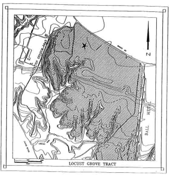 FIGURE 1
Site Location on the Locust Grove Tract of Carter's Grove.
County. The purpose of Phase I and II surveys and Phase III excavation at this site was to
examine the structure and patterns of a small, intact prehistoric site on Virginia's Coastal
Plain.
FIGURE 1
Site Location on the Locust Grove Tract of Carter's Grove.
County. The purpose of Phase I and II surveys and Phase III excavation at this site was to
examine the structure and patterns of a small, intact prehistoric site on Virginia's Coastal
Plain. 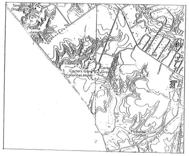 FIGURE 2
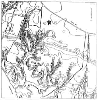 FIGURE 3
 FIGURE 4
 FIGURE 5
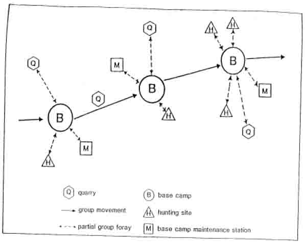 FIGURE 6
 FIGURE 7
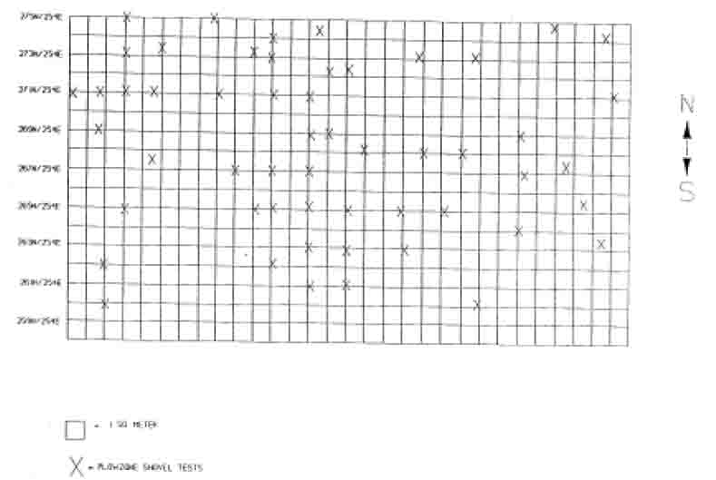 FIGURE 8
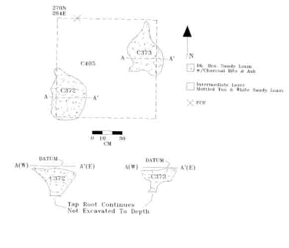 FIGURE 9
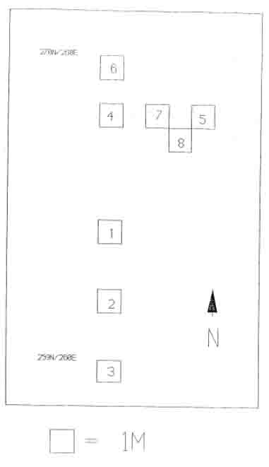 FIGURE 10
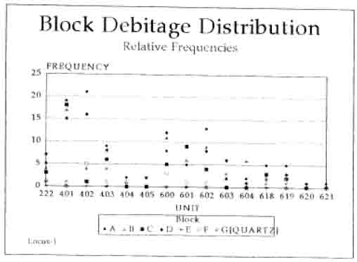 FIGURE 11
 FIGURE 12
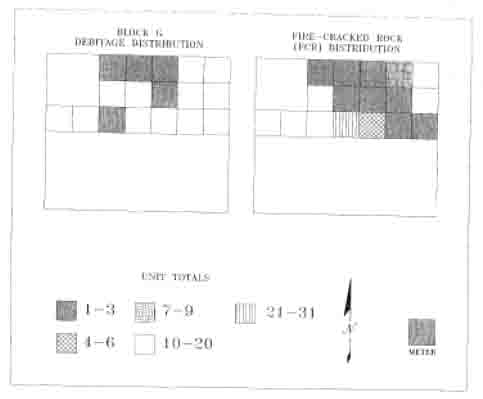 FIGURE 13
 FIGURE 14
 FIGURE 15
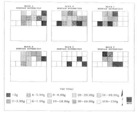 FIGURE 16
Distribution of Quartzite Blocks
A, B, C, D, E, and F by Weight
(Locus-1).
42
FIGURE 16
Distribution of Quartzite Blocks
A, B, C, D, E, and F by Weight
(Locus-1).
42
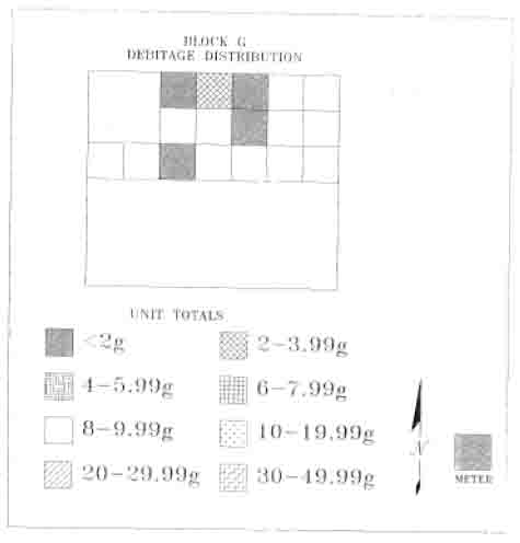 FIGURE 17
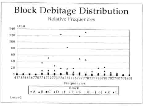 FIGURE 18
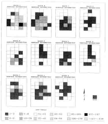 FIGURE 19
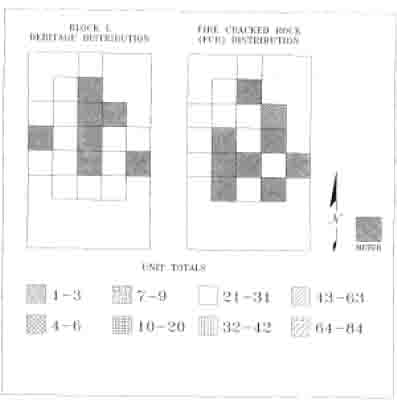 FIGURE 20
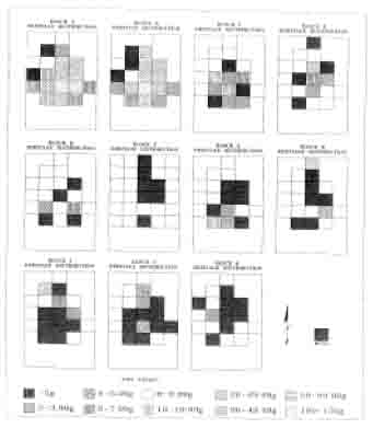 FIGURE 21
 FIGURE 22
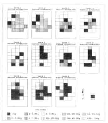 FIGURE 23
 FIGURE 24
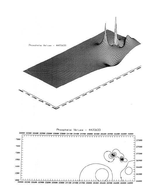 Phosphate Values - 44JC633
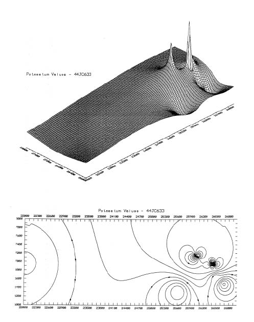 Potassium Values - 44JC633
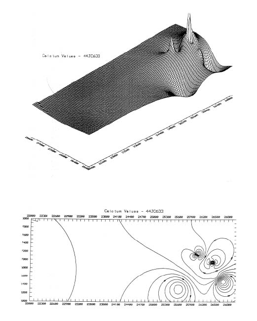 Calcium Values - 44JC633
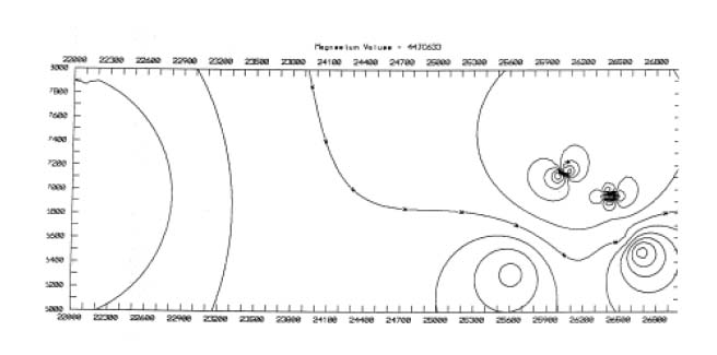 Magnesium Values - 44JC633
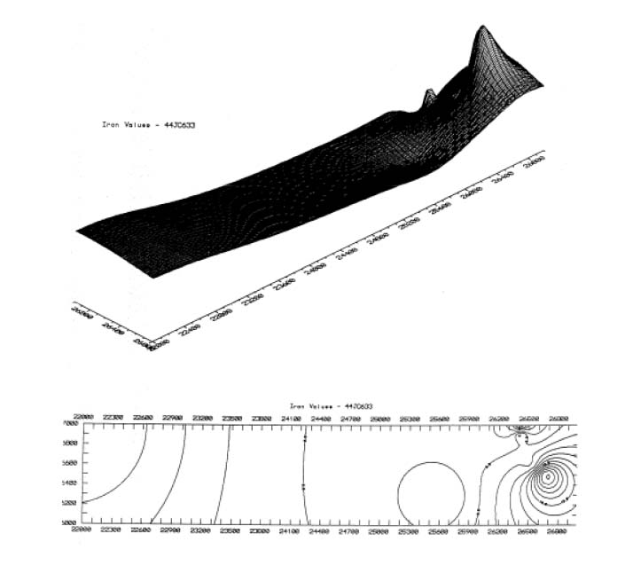 Iron Values - 44JC633
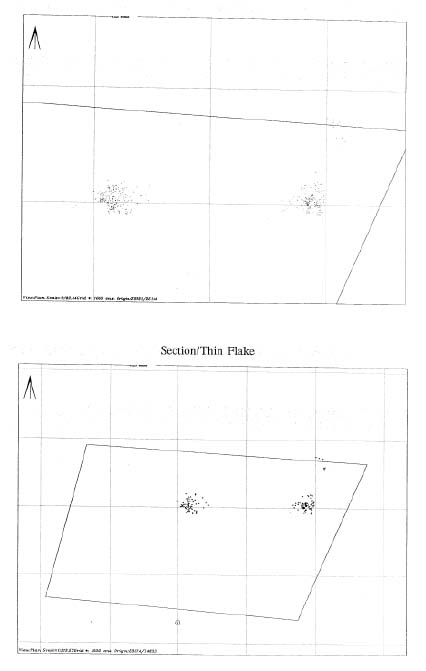 Section/Thin Flake
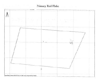 Primary Red Flake
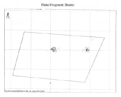 Flake/Fragment Shatter
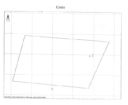 Cores
Cores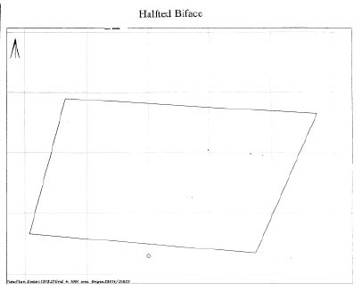 Halfted Biface
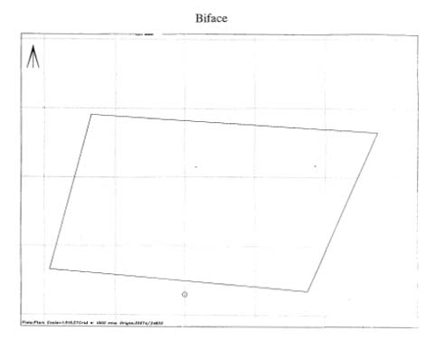 Biface
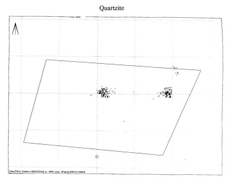 Quartzite
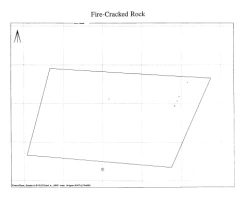 Fire-cracked Rock
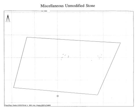 Miscellaneous Unmodified Stone